My
List |
Addition Date
|
Target
|
Mission
|
Instrument
|
Size
|

|
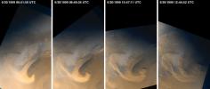
1999-05-20 |
Mars
|
Mars Global Surveyor (MGS)
|
Mars Orbiter Camera (MOC)
|
640x480x3 |
|
-
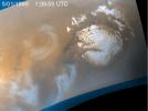
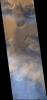
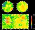
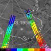
PIA02025:
-
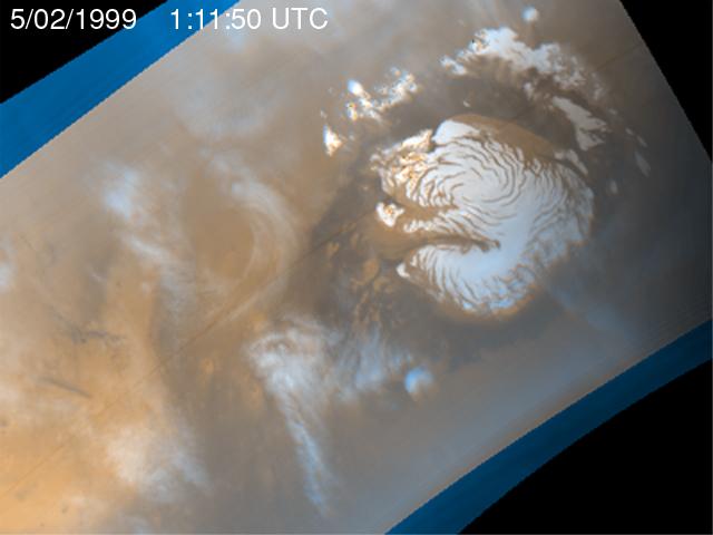
Martian Storm 05/01/99
Full Resolution:
TIFF
(710.3 kB)
JPEG
(25.55 kB)
|
|
|
1999-05-20 |
Mars
|
Mars Global Surveyor (MGS)
|
Mars Orbiter Camera (MOC)
|
640x480x3 |
|
-
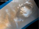
PIA02026:
-
Martian Storm 05/02/99
Full Resolution:
TIFF
(726.7 kB)
JPEG
(27.11 kB)
|
|
|
1999-05-20 |
Mars
|
Mars Global Surveyor (MGS)
|
Mars Orbiter Camera (MOC)
|
640x480x3 |
|
-
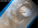
PIA02027:
-
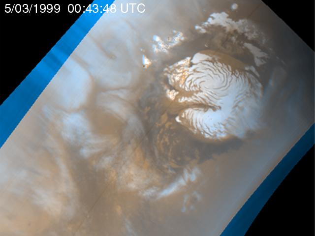
Martian Storm 05/03/99
Full Resolution:
TIFF
(733.7 kB)
JPEG
(27.93 kB)
|
|
|
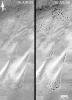
1999-05-20 |
Mars
|
Mars Global Surveyor (MGS)
|
Mars Orbiter Camera (MOC)
|
640x480x3 |

|
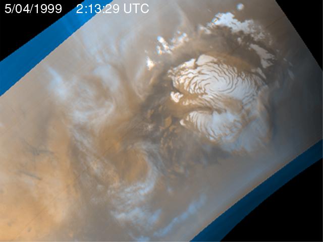
-
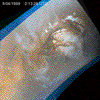
PIA02028:
-
Martian Storm 05/04/99
Full Resolution:
TIFF
(741.8 kB)
JPEG
(27.8 kB)
|
|
|
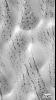
1999-05-26 |
Mars
|
Mars Global Surveyor (MGS)
|
Mars Orbiter Camera (MOC)
|
400x400x3 |
|
-
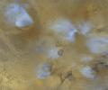
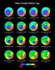
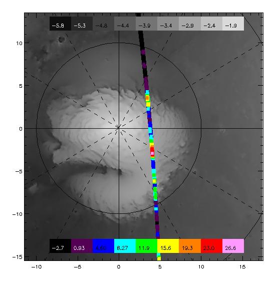
PIA02029:
-
Clouds in North Polar Region Tracked by MOC Over Five Day Period

Full Resolution:
|
|
|
1999-05-27 |
Mars
|
Mars Global Surveyor (MGS)
|
MOLA
|
2497x2221x3 |
|
-
PIA02031:
-
Maps of Mars Global Topography
Full Resolution:
TIFF
(11.74 MB)
JPEG
(1.145 MB)
|
|
|
1999-05-27 |
Mars
|
Mars Global Surveyor (MGS)
|
MOLA
|
1909x2353x3 |
|
-
PIA02033:
-
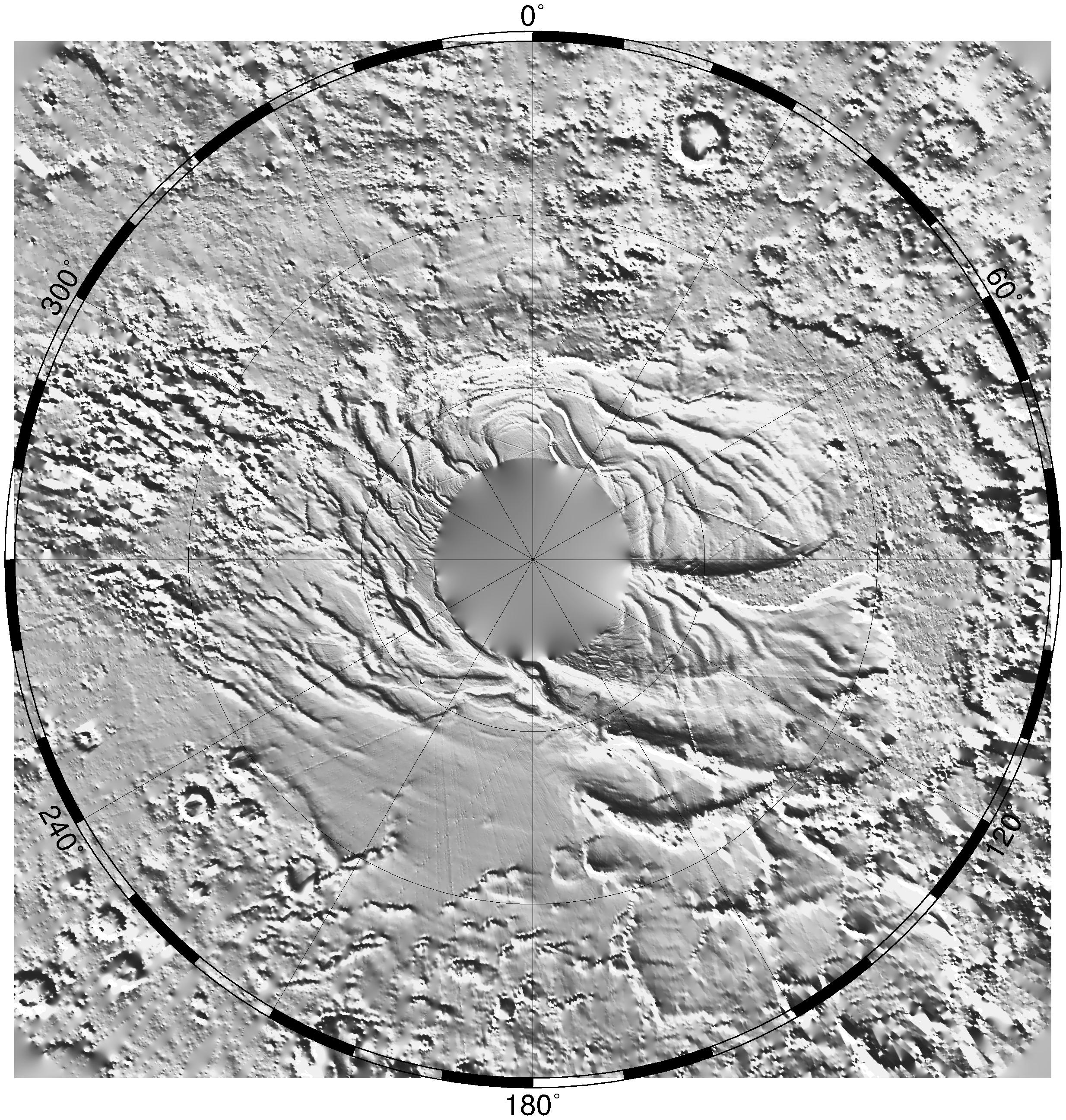
Regional Topographic Model of the Hellas Basin
Full Resolution:
TIFF
(8.461 MB)
JPEG
(901.7 kB)
|
|
|
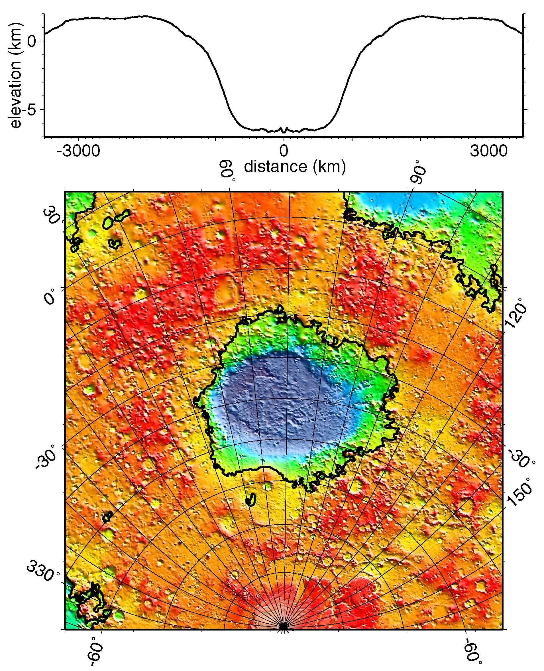
1999-05-27 |
Mars
|
Mars Global Surveyor (MGS)
|
MOLA
|
2761x1759x3 |
|
-
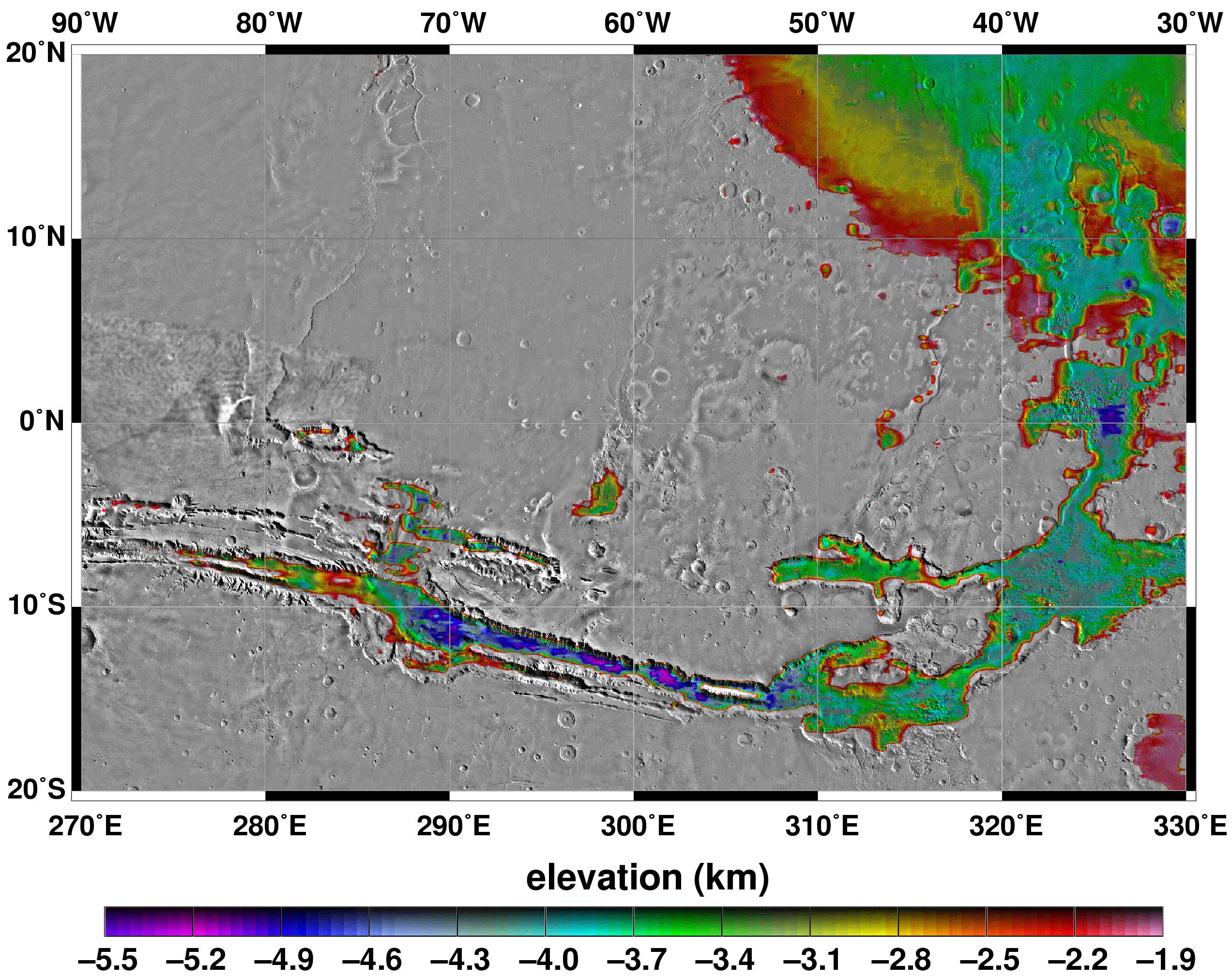
PIA02035:
-
Map of Mars' Topography
Full Resolution:
TIFF
(10.08 MB)
JPEG
(1.115 MB)
|
|
|
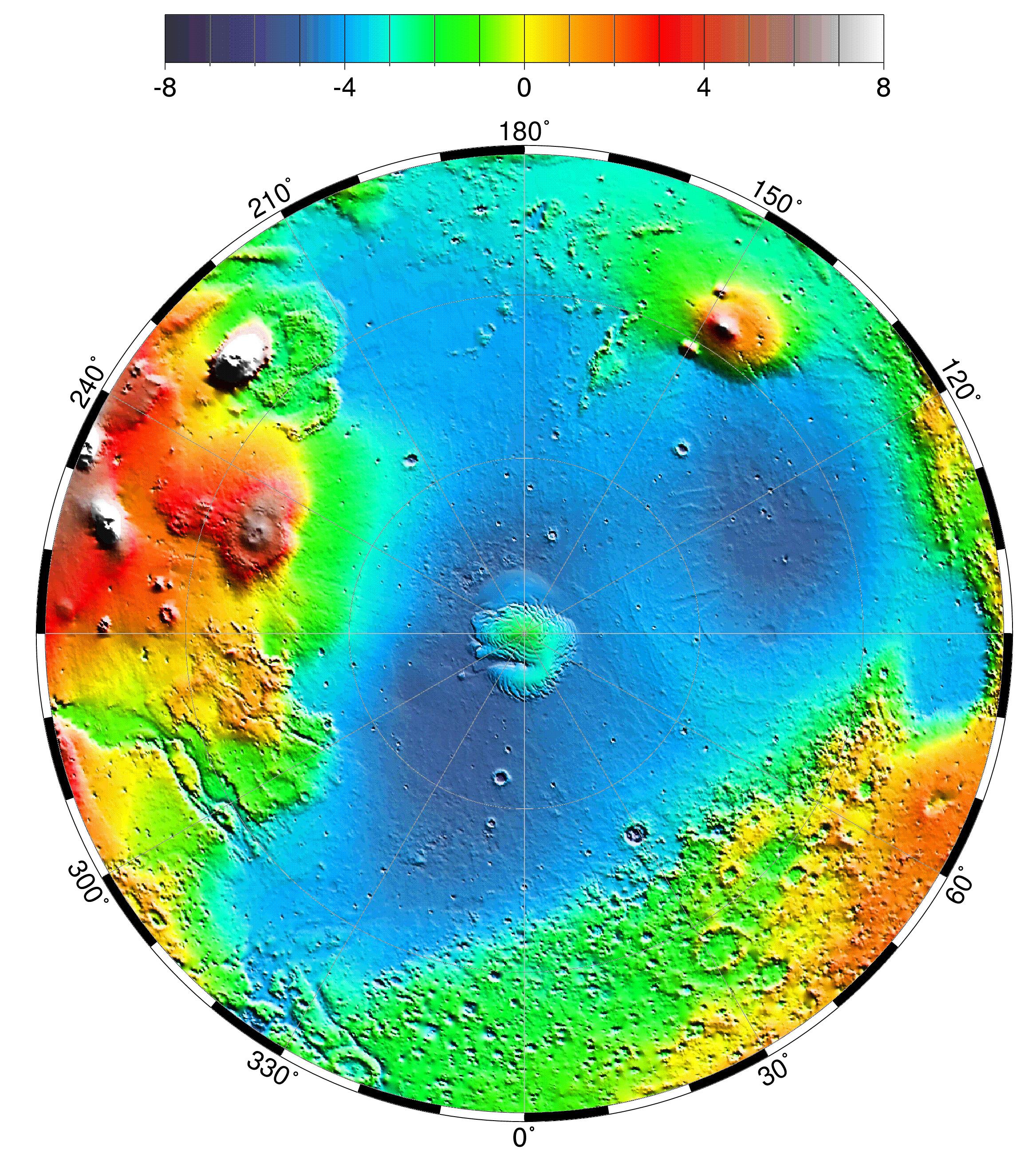
1999-05-27 |
Mars
|
Mars Global Surveyor (MGS)
|
MOLA
|
2335x2617x3 |
|
-
PIA02036:
-
Lambert Equal-Area Projection of Pole-to-Equator
Full Resolution:
TIFF
(12.39 MB)
JPEG
(1.28 MB)
|
|
|
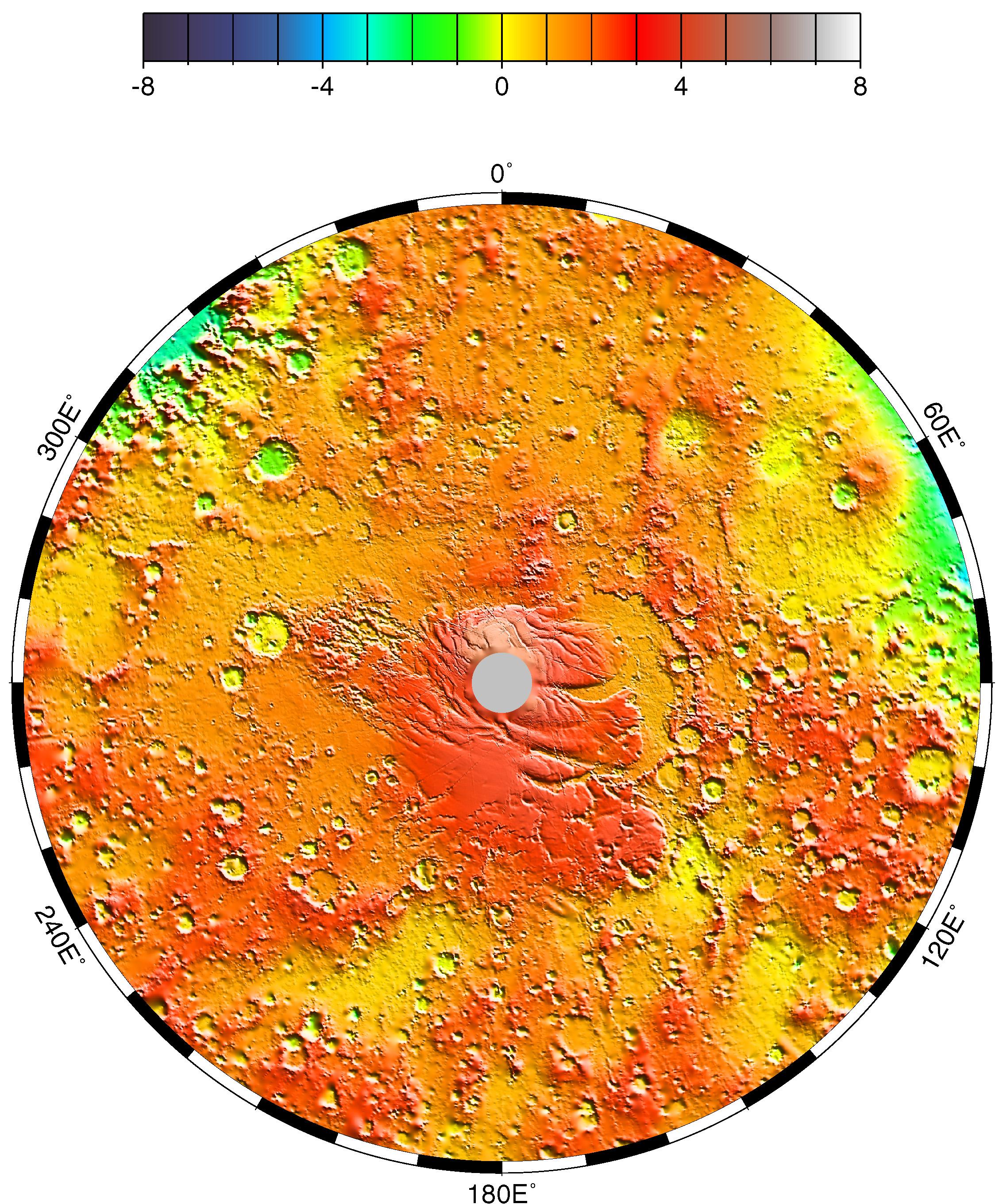
1999-05-27 |
Mars
|
Mars Global Surveyor (MGS)
|
MOLA
|
2257x2719x3 |
|
-
PIA02037:
-
Polar Stereographic Projection
Full Resolution:
TIFF
(13.35 MB)
JPEG
(1.042 MB)
|
|
|
1999-05-27 |
Mars
|
Mars Global Surveyor (MGS)
|
MOLA
|
2545x2023x3 |
|
-
PIA02039:
-
Elevations Within the Floor of the Valles Marineris
Full Resolution:
TIFF
(7.378 MB)
JPEG
(1.035 MB)
|
|
|
1999-05-27 |
Mars
|
Mars Global Surveyor (MGS)
|
MOLA
|
2700x3075x3 |
|
-
PIA02040:
-
Science Magazine Cover Image
Full Resolution:
TIFF
(12.35 MB)
JPEG
(948.9 kB)
|
|
|
2000-06-07 |
Mars
|
Mars Global Surveyor (MGS)
|
Mars Orbiter Camera (MOC)
|
502x2347x1 |
|
-
PIA02043:
-
Eroded, Layered Cratered Highlands of Eastern Arabia Terra
Full Resolution:
TIFF
(1.162 MB)
JPEG
(210.9 kB)
|
|
|
2000-06-07 |
Mars
|
Mars Global Surveyor (MGS)
|
Mars Orbiter Camera (MOC)
|
781x1677x3 |
|
-
PIA02045:
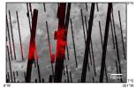
-
May 1999 Dust Storm in Valles Marineris
Full Resolution:
TIFF
(2.463 MB)
JPEG
(93.21 kB)
|
|
|
2000-06-07 |
Mars
|
Mars Global Surveyor (MGS)
|
Mars Orbiter Camera (MOC)
|
559x1820x1 |

|
-
PIA02046:
-
A Martian "Monument Valley" -- Mesas on the Elysium Plains
Full Resolution:
TIFF
(866.8 kB)
JPEG
(144.5 kB)
|
|
|
2000-06-07 |
Mars
|
Mars Global Surveyor (MGS)
|
Mars Orbiter Camera (MOC)
|
512x1265x1 |
|
-
PIA02047:
-
Big, Dark Dunes Northeast of Syrtis Major
Full Resolution:
TIFF
(607.5 kB)
JPEG
(116.8 kB)
|
|
|
2000-06-07 |
Mars
|
Mars Global Surveyor (MGS)
|
Mars Orbiter Camera (MOC)
|
672x1135x1 |
|
-
PIA02048:
-
North Nilosyrtis Mensae
Full Resolution:
TIFF
(707.1 kB)
JPEG
(145.2 kB)
|
|
|
2000-06-07 |
Mars
|
Mars Global Surveyor (MGS)
|
Mars Orbiter Camera (MOC)
|
768x640x3 |
|
-
PIA02049:
-
Regional View of the Tharsis Volcanoes
Full Resolution:
TIFF
(1.379 MB)
JPEG
(60.17 kB)
|
|
|
1999-06-23 |
Mars
|
Mars Global Surveyor (MGS)
|
Magnetometer
|
1700x1144x3 |
|
-
PIA02050:
-
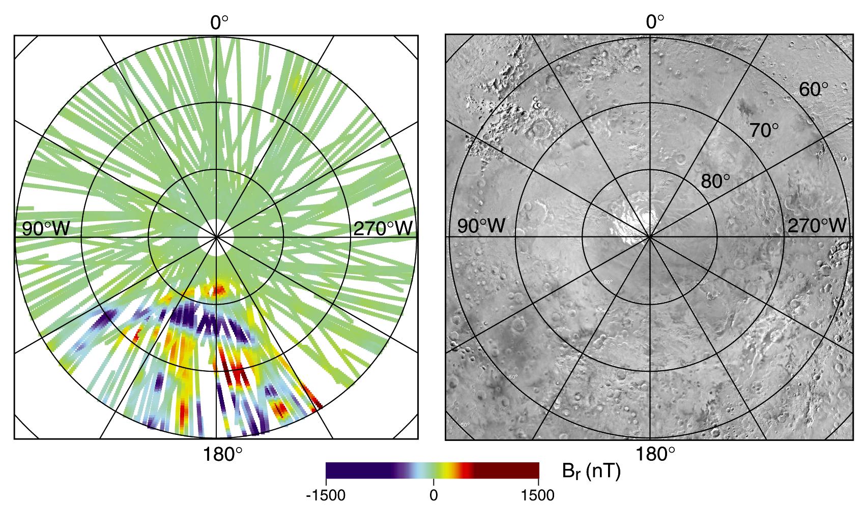
North Polar Magnetic Anomaly Map (MAG/ER)
Full Resolution:
TIFF
(1.938 MB)
JPEG
(213.7 kB)
|
|
|
1999-06-23 |
Mars
|
Mars Global Surveyor (MGS)
|
Magnetometer
|
1700x1046x3 |
|
-
PIA02051:
-
South Polar Magnetic Anomaly Map (MAG/ER)
Full Resolution:
TIFF
(1.582 MB)
JPEG
(306.9 kB)
|
|
|
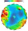
1999-06-23 |
Mars
|
Mars Global Surveyor (MGS)
|
MOLA
|
2468x2592x1 |
|
-
PIA02052:
-
South Polar Topography (MOLA)
Full Resolution:
TIFF
(5.391 MB)
JPEG
(1.241 MB)
|
|
|
1999-06-23 |
Mars
|
Mars Global Surveyor (MGS)
|
MOLA
|
2468x2592x1 |
|
-
PIA02053:
-
North Polar Topography (MOLA)
Full Resolution:
TIFF
(5.755 MB)
JPEG
(1.378 MB)
|
|
|
1999-06-23 |
Mars
|
Mars Global Surveyor (MGS)
|
Imaging Radar
|
2871x2520x3 |
|
-
PIA02054:
-
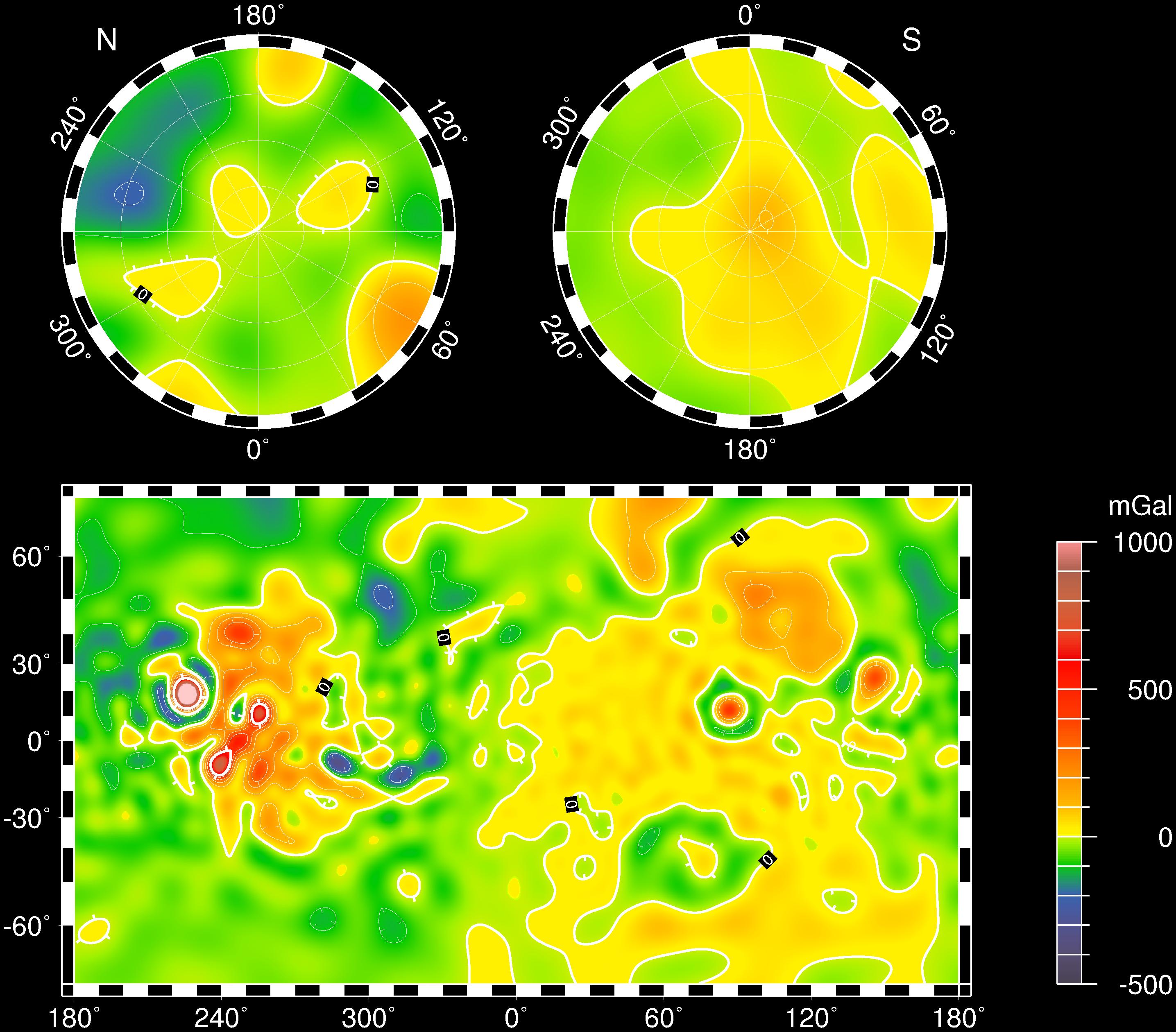
Mars Gravity Map (RS)
Full Resolution:
TIFF
(4.572 MB)
JPEG
(618.1 kB)
|
|
|
1999-06-23 |
Mars
|
Mars Global Surveyor (MGS)
|
Thermal Emission Spectrometer
|
2700x1760x3 |
|
-
PIA02056:
-
Hematite Map (TES)
Full Resolution:
TIFF
(1.342 MB)
JPEG
(592.3 kB)
|
|
|
1999-06-23 |
Mars
|
Mars Global Surveyor (MGS)
|
Thermal Emission Spectrometer
|
1836x2376x3 |
|
-
PIA02057:
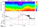
-
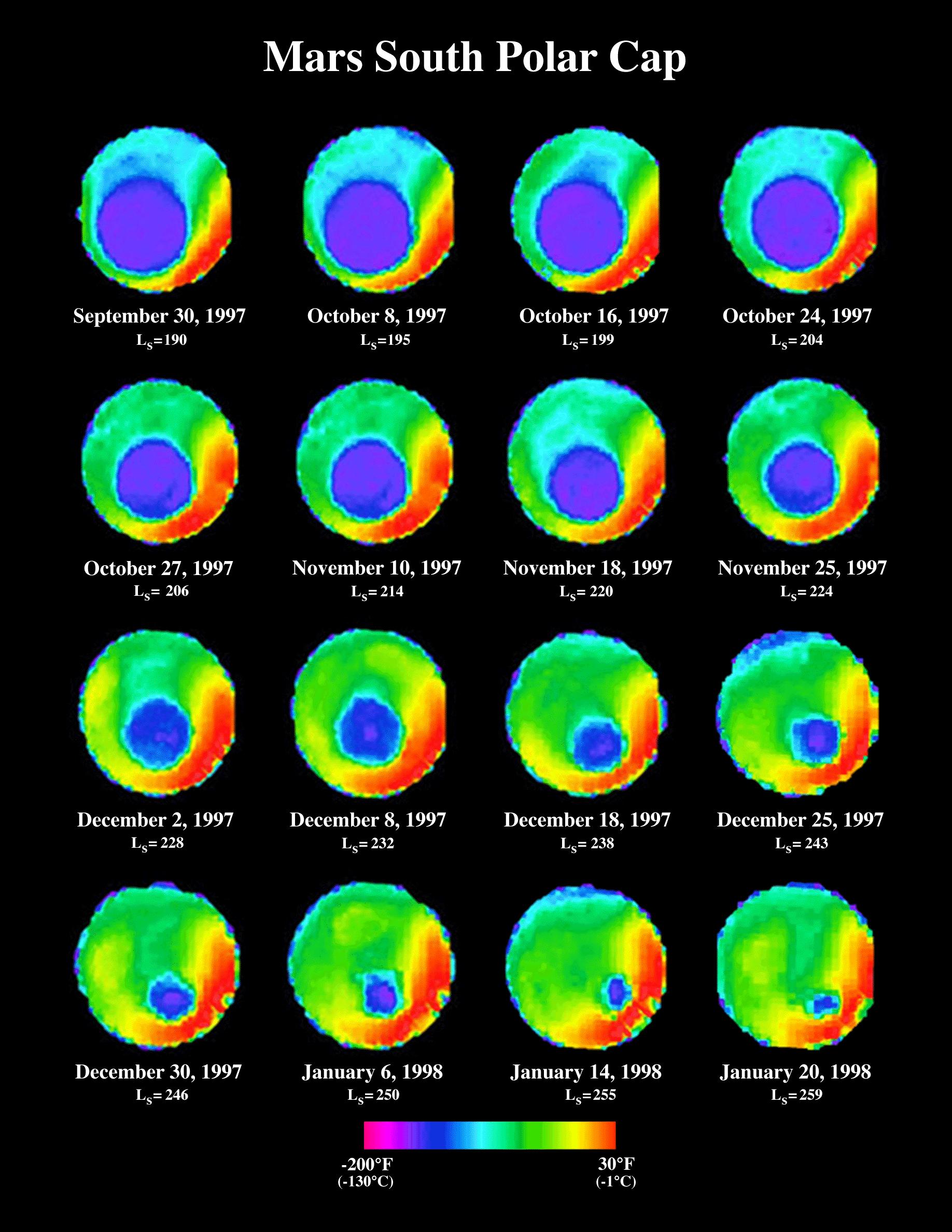
South Polar Cap Thermal Retreat (TES)
Full Resolution:
TIFF
(901.7 kB)
JPEG
(397.6 kB)
|
|
|
1999-06-23 |
Mars
|
Mars Global Surveyor (MGS)
|
Magnetometer
|
1900x1400x3 |
|
-
PIA02058:
-
Electron and Magnetic Field Observations (MAG/ER)
Full Resolution:
TIFF
(321.1 kB)
JPEG
(232.6 kB)
|
|
|
1999-06-23 |
Mars
|
Mars Global Surveyor (MGS)
|
Magnetometer
|
1900x1450x3 |
|
-
PIA02059:
-
Global Map of Magnetic Anomalies (MAG/ER)
Full Resolution:
TIFF
(4.138 MB)
JPEG
(445.2 kB)
|
|
|
1999-06-23 |
Mars
|
Mars Global Surveyor (MGS)
|
Radio Science Subsystem
|
1700x2200x3 |
|
-
PIA02060:
-
Radio-Occultation Profiles (RS)
Full Resolution:
TIFF
(109.9 kB)
JPEG
(175.3 kB)
|
|
|
1999-06-23 |
Mars
|
Mars Global Surveyor (MGS)
|
Thermal Emission Spectrometer
|
1700x2200x3 |
|
-
PIA02061:
-
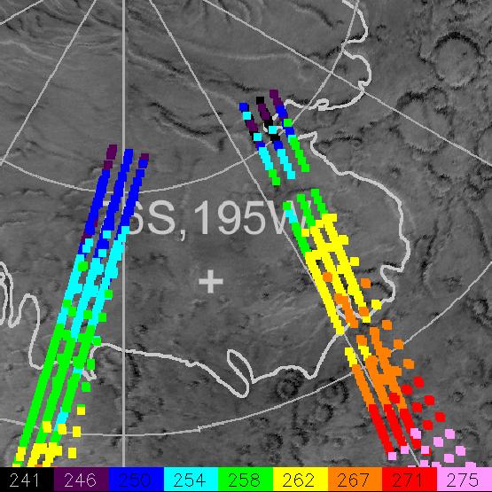
Growth of a Dust Storm (TES)
Full Resolution:
TIFF
(233.5 kB)
JPEG
(390.2 kB)
|
|
|
1999-06-23 |
Mars
|
Mars Global Surveyor (MGS)
|
Thermal Emission Spectrometer
|
2100x3000x3 |
|
-
PIA02062:
-
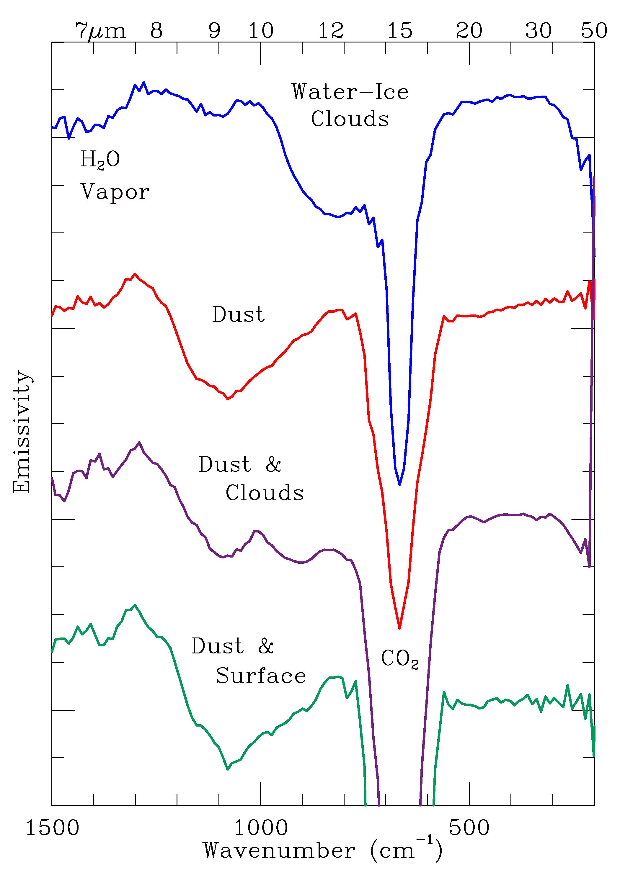
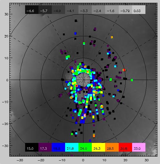
Observed Spectral Classes (TES)
Full Resolution:
TIFF
(213.4 kB)
JPEG
(355.4 kB)
|
|
|
2000-06-07 |
Mars
|
Mars Global Surveyor (MGS)
|
Mars Orbiter Camera (MOC)
|
836x1330x1 |
|
-
PIA02063:
-
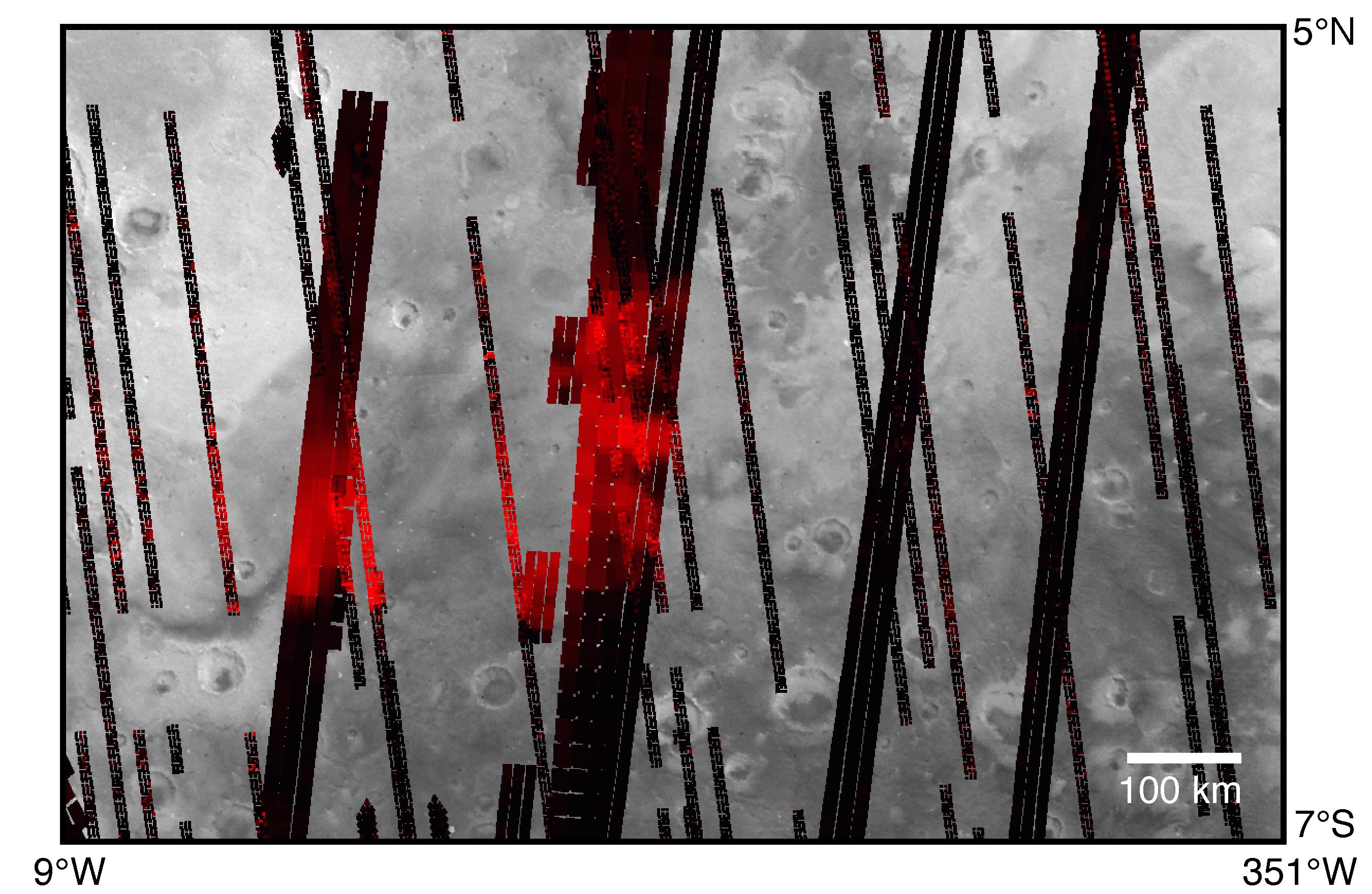
MOC Providing Clues For Future Landing Site Selection
Full Resolution:
TIFF
(867.9 kB)
JPEG
(227.9 kB)
|
|
|
2000-06-07 |
Mars
|
Mars Global Surveyor (MGS)
|
Mars Orbiter Camera (MOC)
|
836x1329x1 |
|
-
PIA02064:
-
MOC Providing Clues For Future Landing Site Selection
Full Resolution:
TIFF
(1.088 MB)
JPEG
(270.6 kB)
|
|
|
1999-06-25 |
Mars
|
Mars Global Surveyor (MGS)
|
Mars Orbiter Camera (MOC)
|
595x860x3 |
|
-
PIA02065:
-
Ganges Chasma in 3-D
Full Resolution:
TIFF
(1.063 MB)
JPEG
(44.04 kB)
|
|
|
2000-06-01 |
Mars
|
Mars Global Surveyor (MGS)
|
Mars Orbiter Camera (MOC)
|
2304x1152x3 |
|
-
PIA02066:
-
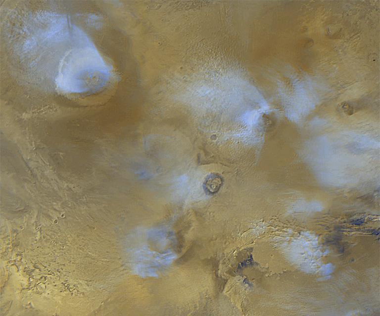
Global Weather
Full Resolution:
TIFF
(6.258 MB)
JPEG
(327.8 kB)
|
|
|
1999-07-19 |
Mars
|
Mars Global Surveyor (MGS)
|
Mars Orbiter Camera (MOC)
|
720x1064x3 |
|
-
PIA02067:
-
Dust Storm
Full Resolution:
TIFF
(1.096 MB)
JPEG
(35.41 kB)
|
|
|
2000-06-02 |
Mars
|
Mars Global Surveyor (MGS)
|
Mars Orbiter Camera (MOC)
|
1024x1375x1 |
|
-
PIA02068:
-
North Polar Sand Dunes
Full Resolution:
TIFF
(1.305 MB)
JPEG
(284.4 kB)
|
|
|
2000-06-01 |
Mars
|
Mars Global Surveyor (MGS)
|
Mars Orbiter Camera (MOC)
|
706x1544x1 |
|
-
PIA02069:
-
Frost-covered Dunes
Full Resolution:
TIFF
(874.8 kB)
JPEG
(139.1 kB)
|
|
|
2000-06-01 |
Mars
|
Mars Global Surveyor (MGS)
|
Mars Orbiter Camera (MOC)
|
1631x2076x1 |

|
-
PIA02070:
-
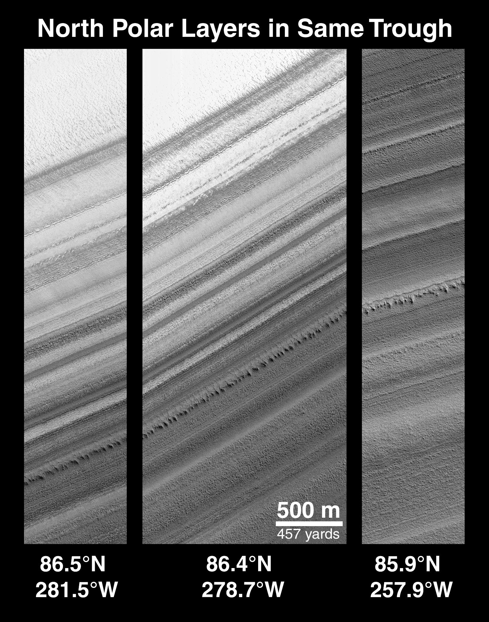
Polar Stratigraphy
Full Resolution:
TIFF
(2.355 MB)
JPEG
(578.6 kB)
|
|
|
1999-07-19 |
Mars
|
Mars Global Surveyor (MGS)
|
Mars Orbiter Camera (MOC)
|
1216x2988x1 |
|
-
PIA02071:
-
Polar Structures
Full Resolution:
TIFF
(3.936 MB)
JPEG
(676.1 kB)
|
|
|
2000-06-01 |
Mars
|
Mars Global Surveyor (MGS)
|
Mars Orbiter Camera (MOC)
|
1024x812x1 |
|
-
PIA02072:
-
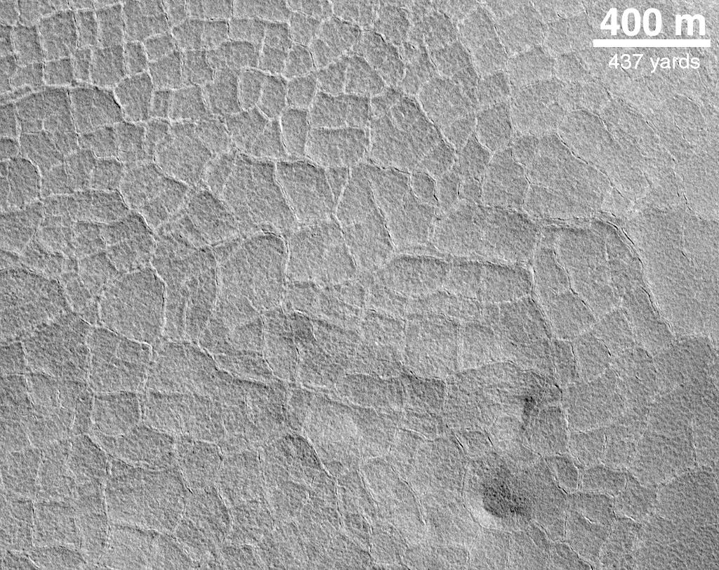
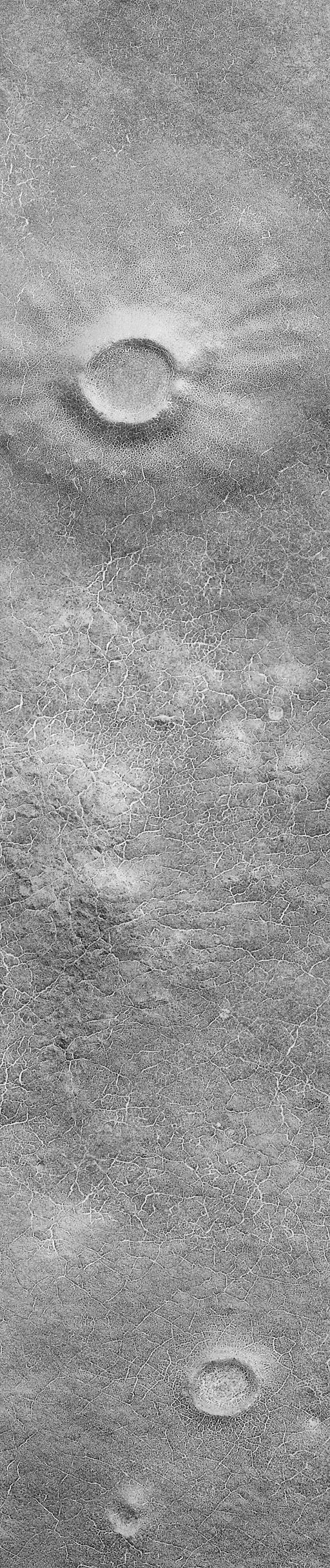
Indications of Subsurface Ice: Polygons on the Northern Plains
Full Resolution:
TIFF
(867.6 kB)
JPEG
(236.7 kB)
|
|
|
1999-07-19 |
Mars
|
Mars Global Surveyor (MGS)
|
Mars Orbiter Camera (MOC)
|
1024x1514x1 |
|
-
PIA02073:
-
Northern Plains
Full Resolution:
TIFF
(1.344 MB)
JPEG
(411.9 kB)
|
|
|
2000-06-01 |
Mars
|
Mars Global Surveyor (MGS)
|
Mars Orbiter Camera (MOC)
|
1024x1514x1 |
|
-
PIA02074:
-
Fretted Terrain Crater
Full Resolution:
TIFF
(1.521 MB)
JPEG
(324.6 kB)
|
|
|
2000-06-01 |
Mars
|
Mars Global Surveyor (MGS)
|
Mars Orbiter Camera (MOC)
|
737x1510x1 |
|
-
PIA02075:
-
Lineated Valley Floor
Full Resolution:
TIFF
(1.293 MB)
JPEG
(306.4 kB)
|
|
|
2000-06-01 |
Mars
|
Mars Global Surveyor (MGS)
|
Mars Orbiter Camera (MOC)
|
717x1400x1 |
|
-
PIA02076:
-
Hrad Vallis
Full Resolution:
TIFF
(970.4 kB)
JPEG
(169 kB)
|
|
|
2000-06-01 |
Mars
|
Mars Global Surveyor (MGS)
|
Mars Orbiter Camera (MOC)
|
717x1399x1 |
|
-
PIA02077:
-
Valley Networks
Full Resolution:
TIFF
(1.014 MB)
JPEG
(188.2 kB)
|
|
|
2000-06-01 |
Mars
|
Mars Global Surveyor (MGS)
|
Mars Orbiter Camera (MOC)
|
672x1125x1 |
|
-
PIA02078:
-
Olympica Fossae
Full Resolution:
TIFF
(642.4 kB)
JPEG
(124.6 kB)
|
|
|
2000-06-01 |
Mars
|
Mars Global Surveyor (MGS)
|
Mars Orbiter Camera (MOC)
|
1241x803x3 |
|
-
PIA02079:
-
Tharsis and Marineris
Full Resolution:
TIFF
(2.895 MB)
JPEG
(150.1 kB)
|
|
|
2000-06-01 |
Mars
|
Mars Global Surveyor (MGS)
|
Mars Orbiter Camera (MOC)
|
717x1059x1 |
|
-
PIA02080:
-
Olympus Lava Flows
Full Resolution:
TIFF
(750 kB)
JPEG
(156.4 kB)
|
|
|
2000-06-01 |
Mars
|
Mars Global Surveyor (MGS)
|
Mars Orbiter Camera (MOC)
|
672x993x1 |
|
-
PIA02081:
-
Daedalia Lava Flow
Full Resolution:
TIFF
(642.9 kB)
JPEG
(137.4 kB)
|
|
|
2000-06-01 |
Mars
|
Mars Global Surveyor (MGS)
|
Mars Orbiter Camera (MOC)
|
614x813x1 |
|
-
PIA02082:
-
Alba Patera Surface
Full Resolution:
TIFF
(566.4 kB)
JPEG
(127 kB)
|
|
|
1999-07-19 |
Mars
|
Mars Global Surveyor (MGS)
|
Mars Orbiter Camera (MOC)
|
1256x1857x1 |

|
-
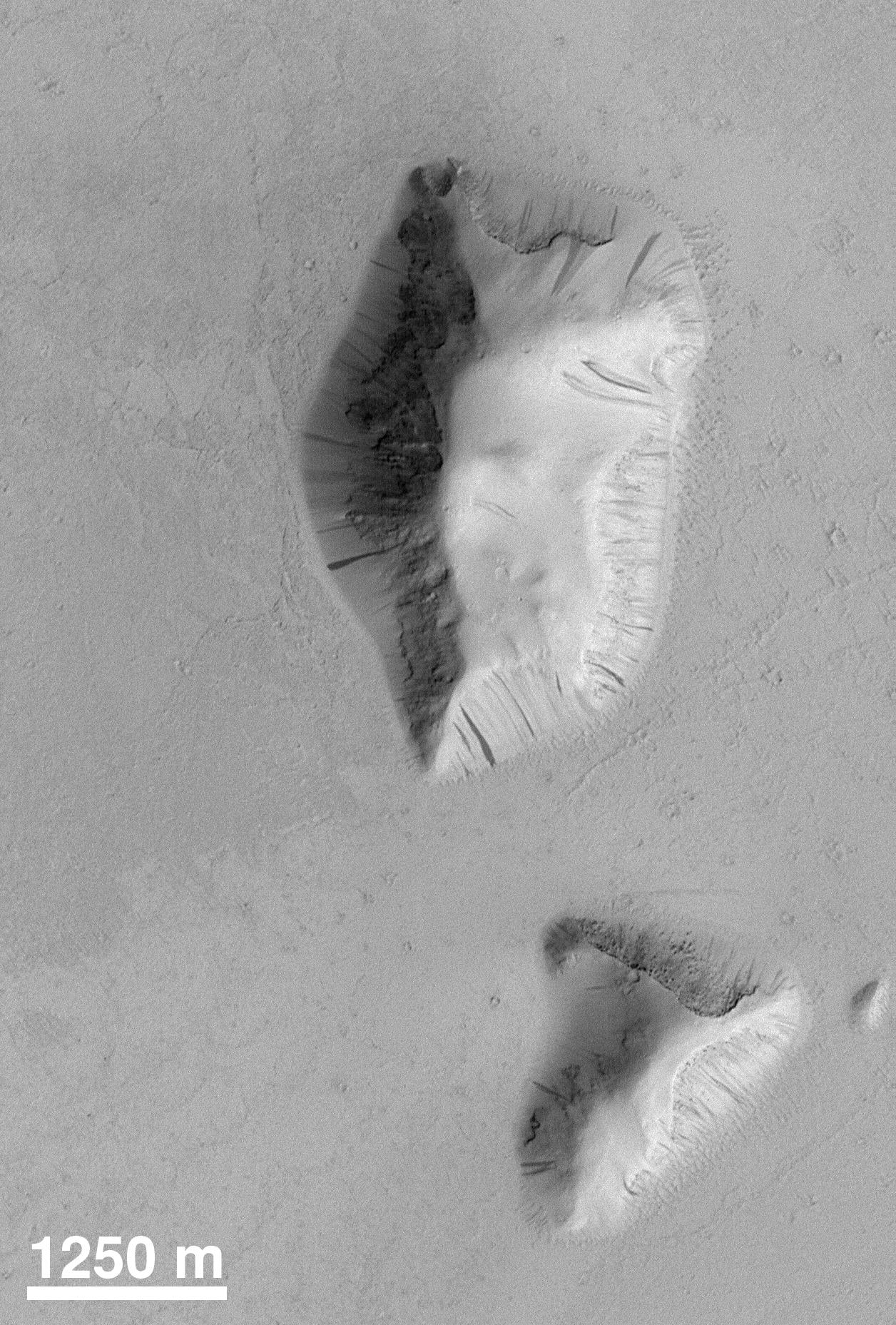
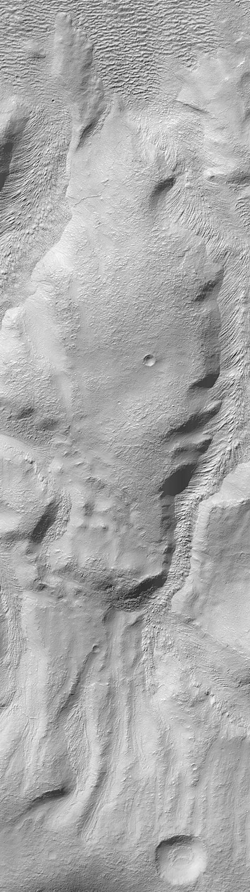
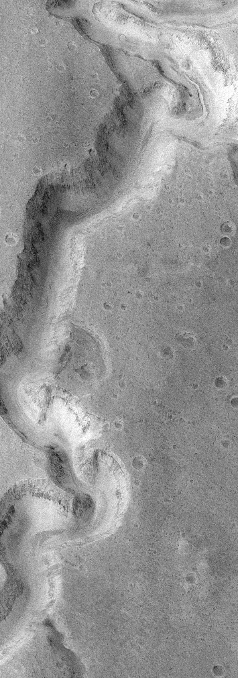
PIA02083:
-
Slope Processes
Full Resolution:
TIFF
(2.393 MB)
JPEG
(475.6 kB)
|
|
|
1999-07-19 |
Mars
|
Mars Global Surveyor (MGS)
|
Mars Orbiter Camera (MOC)
|
1024x1536x1 |
|
-
PIA02084:
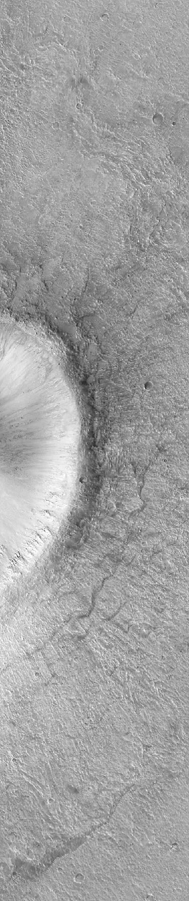
-
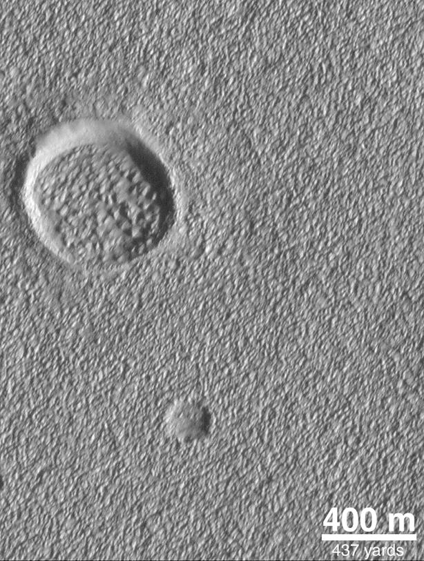
Martian Crater
Full Resolution:
TIFF
(1.547 MB)
JPEG
(261.2 kB)
|
|
|
2000-06-01 |
Mars
|
Mars Global Surveyor (MGS)
|
Mars Orbiter Camera (MOC)
|
819x1211x1 |
|
-
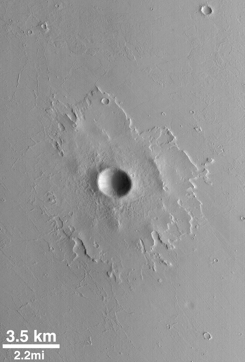
PIA02085:
-
Pedestal Crater
Full Resolution:
TIFF
(838.2 kB)
JPEG
(146.8 kB)
|
|
|
1999-07-02 |
Mars
|
Mars Global Surveyor (MGS)
|
Mars Orbiter Camera (MOC)
|
499x1778x1 |
|
-
PIA02086:
-
Martian Mystery: Do Some Materials Flow Uphill?
Full Resolution:
TIFF
(984.3 kB)
JPEG
(211.8 kB)
|
|
|
1999-07-02 |
Mars
|
Mars Global Surveyor (MGS)
|
Mars Orbiter Camera (MOC)
|
550x555x1 |
|
-
PIA02087:
-
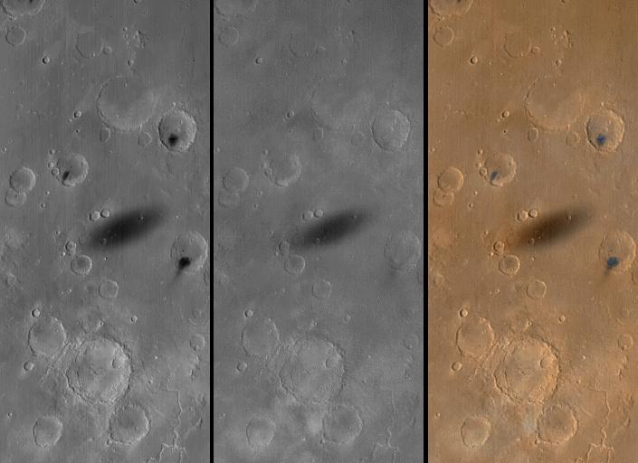
Large Martian Dust Devils Caught in the Act
Full Resolution:
TIFF
(108.1 kB)
JPEG
(18.93 kB)
|
|
|
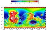
1999-07-06 |
Mars
|
Mars Global Surveyor (MGS)
|
MOLA
|
612x792x3 |
|
-
PIA02088:
-
MOLA TOPOGRAPHIC MAP
Full Resolution:
TIFF
(1.326 MB)
JPEG
(182.1 kB)
|
|
|
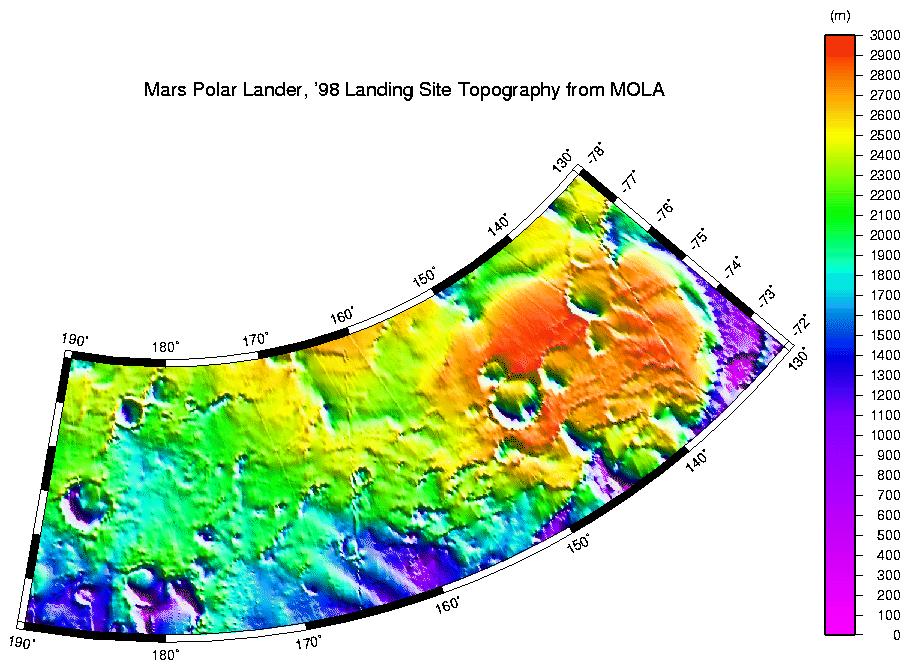
1999-07-06 |
Mars
|
Mars Global Surveyor (MGS)
|
MOLA
|
910x670x3 |
|
-
PIA02089:
-
MPL LANDING SITE - DEM
Full Resolution:
TIFF
(172.2 kB)
JPEG
(111.2 kB)
|
|
|
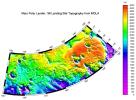
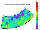
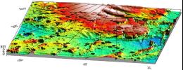
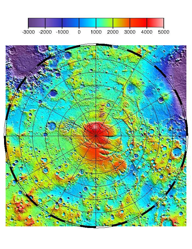
1999-07-06 |
Mars
|
Mars Global Surveyor (MGS)
|
MOLA
|
910x685x3 |
|
-
PIA02090:
-
MPL LANDING SITE CORRIDOR
Full Resolution:
TIFF
(151.7 kB)
JPEG
(86.71 kB)
|
|
|
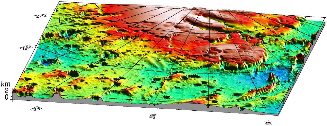
1999-07-06 |
Mars
|
Mars Global Surveyor (MGS)
|
MOLA
|
1280x493x3 |
|
-
PIA02091:
-
Mars '98 Polar landing site
Full Resolution:
TIFF
(1.607 MB)
JPEG
(150 kB)
|
|
|
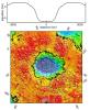
1999-07-09 |
Mars
|
Mars Global Surveyor (MGS)
|
Mars Orbiter Camera (MOC)
|
415x3214x1 |

|
-
PIA02092:
-
New Cydonia Picture
Full Resolution:
TIFF
(1.158 MB)
JPEG
(186.2 kB)
|
|
|
2000-06-01 |
Mars
|
Mars Global Surveyor (MGS)
|
Mars Orbiter Camera (MOC)
|
376x1790x1 |
|
-
PIA02093:
-
Detail of an Impact Crater, Acidalia Planitia
Full Resolution:
TIFF
(689.6 kB)
JPEG
(164.8 kB)
|
|
|
2000-06-01 |
Mars
|
Mars Global Surveyor (MGS)
|
Mars Orbiter Camera (MOC)
|
831x2367x1 |
|
-
PIA02094:
-
Water: Sustained Flow
Full Resolution:
TIFF
(2.177 MB)
JPEG
(456 kB)
|
|
|
2000-06-01 |
Mars
|
Mars Global Surveyor (MGS)
|
Mars Orbiter Camera (MOC)
|
512x1030x1 |
|
-
PIA02095:
-
Winter Frosts of the Retreating South Polar Cap
Full Resolution:
TIFF
(402.7 kB)
JPEG
(111.2 kB)
|
|
|
2000-06-01 |
Mars
|
Mars Global Surveyor (MGS)
|
Mars Orbiter Camera (MOC)
|
552x1012x3 |
|
-
PIA02096:
-
Southern Mars: It's Spring!
Full Resolution:
TIFF
(1.177 MB)
JPEG
(38.04 kB)
|
|
|
2000-05-26 |
Mars
|
Mars Global Surveyor (MGS)
|
Mars Orbiter Camera (MOC)
|
549x921x1 |
|
-
PIA02300:
-
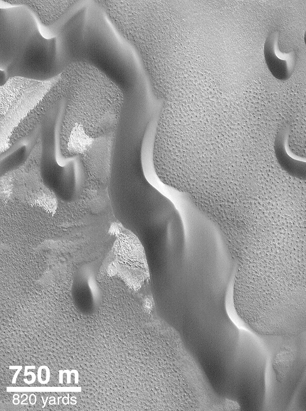
Defrosting Polar Dunes--"They Look Like Bushes!"
Full Resolution:
TIFF
(421.2 kB)
JPEG
(118.9 kB)
|
|
|
2000-05-16 |
Mars
|
Mars Global Surveyor (MGS)
|
Mars Orbiter Camera (MOC)
|
669x1216x1 |
|
-
PIA02301:
-
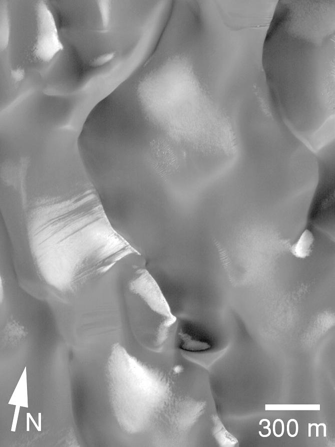
Defrosting Polar Dunes -- "The Snow Leopard"
Full Resolution:
TIFF
(710.6 kB)
JPEG
(145.6 kB)
|
|
|
2000-05-16 |
Mars
|
Mars Global Surveyor (MGS)
|
Mars Orbiter Camera (MOC)
|
481x677x1 |
|
-
PIA02302:
-
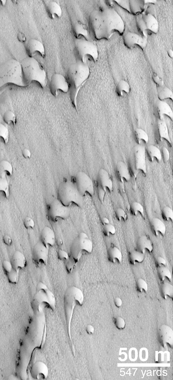
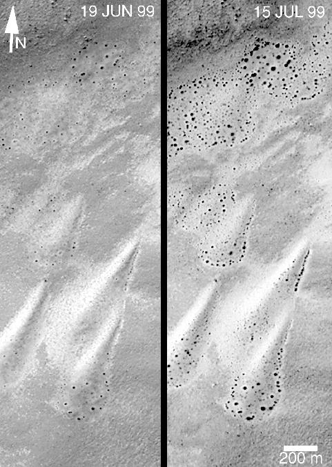
Defrosting Polar Dunes--Changes Over a 26-Day Period
Full Resolution:
TIFF
(287.7 kB)
JPEG
(71.03 kB)
|
|
|
2000-05-16 |
Mars
|
Mars Global Surveyor (MGS)
|
Mars Orbiter Camera (MOC)
|
598x643x1 |

|
-
PIA02303:
-
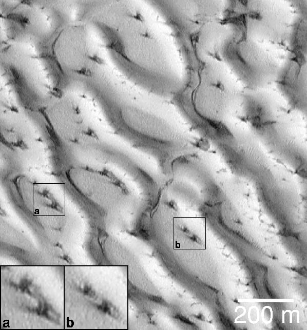
Defrosting Polar Dunes--Dark Spots and Wind Streaks
Full Resolution:
TIFF
(326.8 kB)
JPEG
(59.63 kB)
|
|
|
2000-05-16 |
Mars
|
Mars Global Surveyor (MGS)
|
Mars Orbiter Camera (MOC)
|
669x892x1 |

|
-
PIA02304:
-
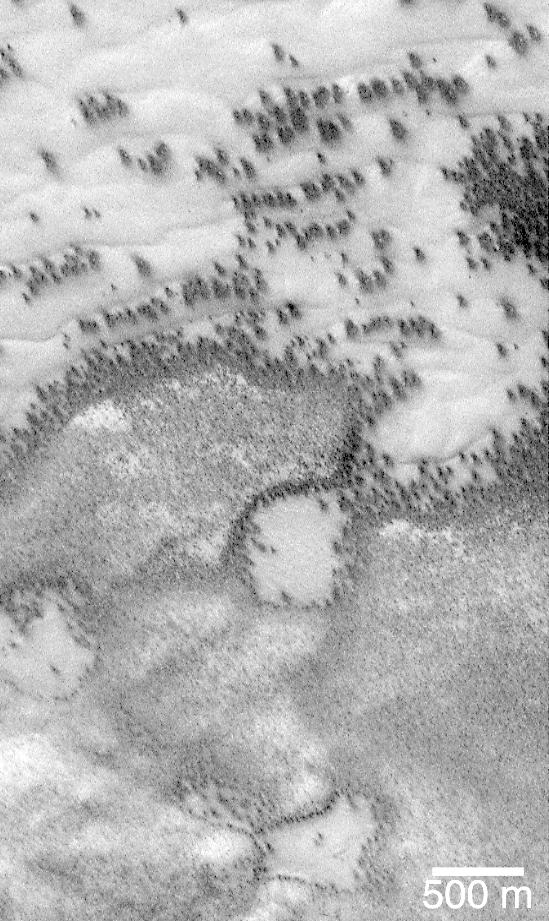
Dune Activity in Proctor Crater
Full Resolution:
TIFF
(387.7 kB)
JPEG
(41.6 kB)
|
|
|
2000-05-16 |
Mars
|
Mars Global Surveyor (MGS)
|
Mars Orbiter Camera (MOC)
|
1019x432x3 |
|
-
PIA02305:
-
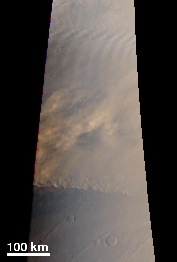
Late Summer Storms Over the Mars North Polar Region
Full Resolution:
TIFF
(784.1 kB)
JPEG
(36.07 kB)
|
|
|
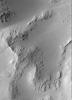
2000-05-27 |
Mars
|
Mars Global Surveyor (MGS)
|
Mars Orbiter Camera (MOC)
|
836x1169x1 |
|
-
PIA02306:
-
A Typical Martian Scene: Boulders and Slopes in a Crater in Aeolis
Full Resolution:
TIFF
(760.1 kB)
JPEG
(127.2 kB)
|
|
|
1999-08-17 |
Mars
|
Mars Global Surveyor (MGS)
|
Thermal Emission Spectrometer
|
551x561x3 |
|
-
PIA02307:
-
TES overlayed on MOLA DEM
Full Resolution:
TIFF
(119.9 kB)
JPEG
(34.92 kB)
|
|
|
2000-05-16 |
Mars
|
Mars Global Surveyor (MGS)
|
Mars Orbiter Camera (MOC)
|
987x708x3 |
|
-
PIA02310:
-
MGS MOC Coverage of Mars Polar Lander Region
Full Resolution:
TIFF
(245.9 kB)
JPEG
(136.1 kB)
|
|
|
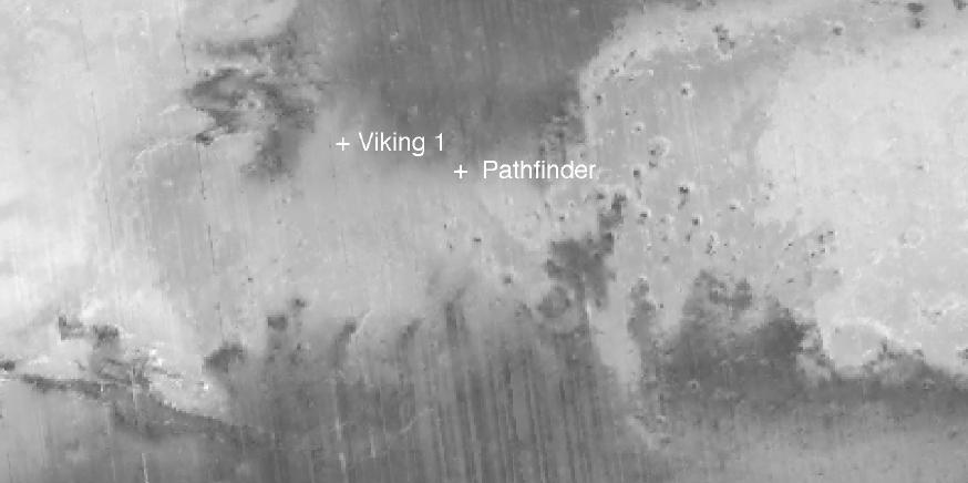
1999-08-25 |
Mars
|
Mars Global Surveyor (MGS)
|
Mars Orbiter Camera (MOC)
|
1145x1100x1 |
|
-
PIA02311:
-
Mars Polar Lander and Mars Pathfinder Sites Compared
Full Resolution:
TIFF
(1.24 MB)
JPEG
(315.7 kB)
|
|
|
2000-05-16 |
Mars
|
Mars Global Surveyor (MGS)
|
Mars Orbiter Camera (MOC)
|
672x475x1 |
|
-
PIA02312:
-
Mars Polar Lander Site Surface Details
Full Resolution:
TIFF
(298.3 kB)
JPEG
(86.12 kB)
|
|
|
2000-05-16 |
Mars
|
Mars Global Surveyor (MGS)
|
Mars Orbiter Camera (MOC)
|
726x489x1 |
|
-
PIA02313:
-
Mars Polar Lander Site Compared With Washington, D.C.
Full Resolution:
TIFF
(365.8 kB)
JPEG
(98.56 kB)
|
|
|
1999-08-26 |
Mars
|
Mars Global Surveyor (MGS)
Viking
|
|
1600x900x3 |
|
-
PIA02314:
-
Proposed Mars Polar Lander Landing Site (Flat Map)
Full Resolution:
TIFF
(3.895 MB)
JPEG
(258.4 kB)
|
|
|
1999-08-26 |
Mars
|
Mars Global Surveyor (MGS)
Viking
|
|
2560x1920x3 |
|
-
PIA02315:
-
Proposed Mars Polar Lander Landing Site (Global Perspective)
Full Resolution:
TIFF
(7.41 MB)
JPEG
(513.2 kB)
|
|
|
1999-08-26 |
Mars
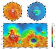
|
Mars Global Surveyor (MGS)
Viking
|
|
2560x1920x3 |
|
-
PIA02316:
-
Proposed Mars Polar Lander Landing Site (Perspective View 1)
Full Resolution:
TIFF
(11.63 MB)
JPEG
(436.4 kB)
|
|
|
1999-08-26 |
Mars
|
Mars Global Surveyor (MGS)
Viking
|
|
2560x1920x3 |
|
-
PIA02317:
-
Proposed Mars Polar Lander Landing Site (Perspective View 2)
Full Resolution:
TIFF
(10.63 MB)
JPEG
(353 kB)
|
|
|
1999-08-26 |
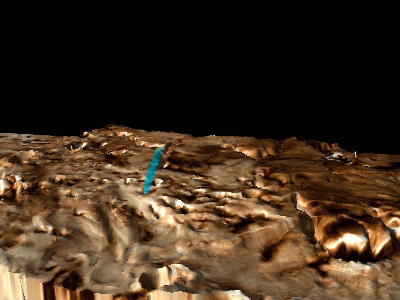
Mars
|
Mars Global Surveyor (MGS)
Viking
|
|
1280x960x3 |
|
-
PIA02318:
-
Proposed Mars Polar Lander Landing Site (Perspective View 3)
Full Resolution:
TIFF
(2.251 MB)
JPEG
(110.4 kB)
|
|
|
1999-08-31 |
Mars
|
Mars Global Surveyor (MGS)
|
Thermal Emission Spectrometer
|
874x436x1 |

|
-
PIA02320:
-
New Views of Mars from the Thermal Emission Spectrometer Instrument
Full Resolution:
TIFF
(254.5 kB)
JPEG
(34.33 kB)
|
|
|
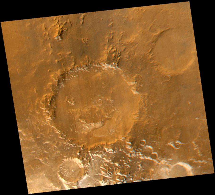
2000-05-16 |
Mars
|
Mars Global Surveyor (MGS)
|
Mars Orbiter Camera (MOC)
|
913x831x3 |
|
-
PIA02325:
-
Have a Nice Spring! MOC Revisits "Happy Face" Crater
Full Resolution:
TIFF
(1.933 MB)
JPEG
(80.21 kB)
|
|
|
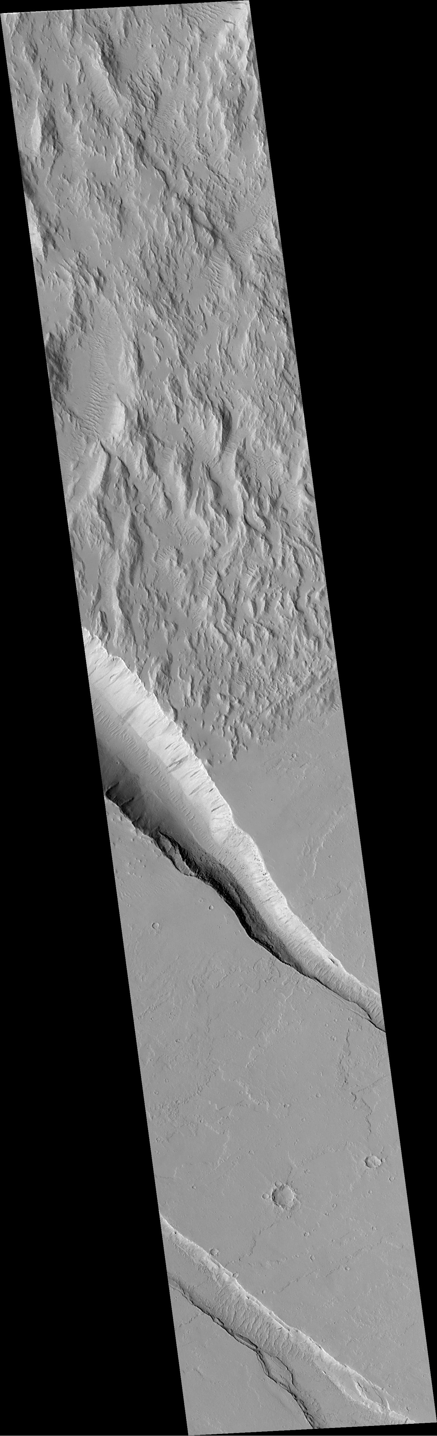
2000-05-13 |
Mars
|
Mars Global Surveyor (MGS)
|
Mars Orbiter Camera (MOC)
|
1468x4825x1 |
|
-
PIA02326:
-
Diverse Geologic Features of Western Tharsis, Mars
Full Resolution:
TIFF
(3.081 MB)
JPEG
(573.5 kB)
|
|
|
1999-09-18 |
Mars
|
Mars Global Surveyor (MGS)
|
Thermal Emission Spectrometer
|
555x555x3 |
|
-
PIA02327:
-
Mars Polar Lander Landing Site Noon-time Temperatures
Full Resolution:
TIFF
(210.4 kB)
JPEG
(69.04 kB)
|
|
|
1999-09-18 |
Mars
|
Mars Global Surveyor (MGS)
|
Thermal Emission Spectrometer
|
516x529x3 |
|
-
PIA02328:
-
Slab Ice and Snow Flurries in the Mars Northern Polar Night
Full Resolution:
TIFF
(102.1 kB)
JPEG
(46.41 kB)
|
|
|
1999-09-10 |
Mars
|
Mars Climate Orbiter
|
MARCI
|
200x200x3 |
|
-
PIA02330:
-
Mars Climate Orbiter MARCI Approach Image
Full Resolution:
TIFF
(3.396 kB)
JPEG
(2.93 kB)
|
|
|
2000-05-13 |
Mars
|
Mars Global Surveyor (MGS)
|
Mars Orbiter Camera (MOC)
|
1142x2376x1 |
|
-
PIA02331:
-
Mars Global Surveyor MOC Celebrates 2 Years in Orbit!
Full Resolution:
TIFF
(1.194 MB)
JPEG
(262.5 kB)
|
|
|
1999-09-18 |
Mars
|
Mars Global Surveyor (MGS)
|
Thermal Emission Spectrometer
|
500x500x3 |

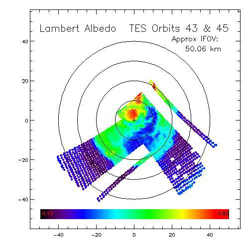
|
-
PIA02332:
-
Dark Dry Ice on Southern Cap - Lambert Albedo Image
Full Resolution:
TIFF
(201.7 kB)
JPEG
(46.54 kB)
|
|
|
1999-09-18 |
Mars
|
Mars Global Surveyor (MGS)
|
Thermal Emission Spectrometer
|
500x500x3 |
|
-
PIA02333:
-
Dark Dry Ice on Southern Cap - Thermal Image
Full Resolution:
TIFF
(199.5 kB)
JPEG
(44.24 kB)
|
|
|
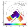
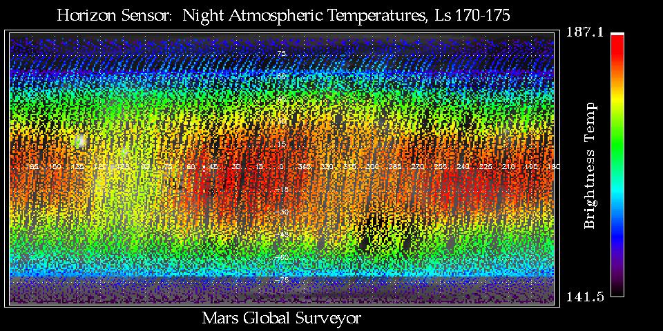
1999-09-18 |
Mars
|
Mars Global Surveyor (MGS)
|
Mars Horizon Sensor Assembly
|
960x480x3 |
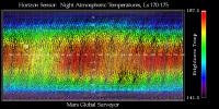
|
-
PIA02335:
-
Thermal Wave Phenomena
Full Resolution:
TIFF
(168.1 kB)
JPEG
(191.6 kB)
|
|
|
2000-05-13 |
Mars
|
Mars Global Surveyor (MGS)
|
Mars Orbiter Camera (MOC)
|
550x844x3 |
|
-
PIA02336:
-
The Mysterious Martian Mountains of Mitchel
Full Resolution:
TIFF
(673.9 kB)
JPEG
(37.08 kB)
|
|
|
2000-05-13 |
Mars
|
Mars Global Surveyor (MGS)
|
Mars Orbiter Camera (MOC)
|
742x508x3 |
|
-
PIA02337:
-
Wide Angle View of Arsia Mons Volcano
Full Resolution:
TIFF
(810.7 kB)
JPEG
(32.44 kB)
|
|
|
2000-05-15 |
Mars
|
Mars Global Surveyor (MGS)
|
Mars Orbiter Camera (MOC)
|
733x1048x1 |

|
-
PIA02338:
-
Mars Shoreline Tests: Contact between Lycus Sulci and Amazonis Planitia
Full Resolution:
TIFF
(646.2 kB)
JPEG
(152 kB)
|
|
|
2000-05-13 |
Mars
|
Mars Global Surveyor (MGS)
|
Mars Orbiter Camera (MOC)
|
418x802x1 |
|
-
PIA02339:
-
Autumn Frost, North Polar Sand Dunes
Full Resolution:
TIFF
(267.1 kB)
JPEG
(70.98 kB)
|
|
|
2000-05-15 |
Mars
|
Mars Global Surveyor (MGS)
|
Mars Orbiter Camera (MOC)
|
1672x2195x1 |
|
-
PIA02340:
-
The Terrain of Margaritifer Chaos
Full Resolution:
TIFF
(3.346 MB)
JPEG
(583.2 kB)
|
|
|
2000-05-15 |
Mars
|
Mars Global Surveyor (MGS)
|
Mars Orbiter Camera (MOC)
|
1024x2331x1 |
|
-
PIA02341:
-
Possible Rootless Cones or Pseudo craters on Mars
Full Resolution:
TIFF
(1.873 MB)
JPEG
(655.3 kB)
|
|
|
2000-05-13 |
Mars
|
Mars Global Surveyor (MGS)
|
Mars Orbiter Camera (MOC)
|
705x512x3 |
|
-
PIA02342:
-
MOC Views of Martian Solar Eclipses
Full Resolution:
TIFF
(591.9 kB)
JPEG
(42.94 kB)
|
|
|
2000-05-13 |
Mars
|
Mars Global Surveyor (MGS)
|
Mars Orbiter Camera (MOC)
|
836x2986x1 |
|
-
PIA02343:
-
Layers and Boulders in Crater Wall, Nepenthes Mensae Region
Full Resolution:
TIFF
(2.206 MB)
JPEG
(480.7 kB)
|
|
|
2000-05-13 |
Mars
|
Mars Global Surveyor (MGS)
|
Mars Orbiter Camera (MOC)
|
512x2432x1 |
|
-
PIA02344:
-
Patterned Ground of the Martian Antarctic
Full Resolution:
TIFF
(1.439 MB)
JPEG
(479.7 kB)
|
 Planetary Data System


