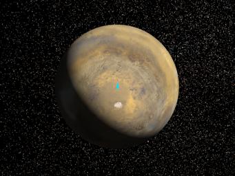
A mosaic of 24 images taken on a single northern summer day in April 1999 are stitched together to create a global view of Mars. We rotate the planet to reveal the South Pole. Viking data is used to fill in some of this region which is in darkness during this season. The landing site is located at latitude 76degrees South, longitude 195 degrees West. A bright blue ellipse indicates the landing location of the landing site. The ellipse is 5 kilometers wide and 90 kilometers long.
Launched Jan. 3, Mars Polar Lander will set down gently on the Red Planet Dec. 3 for the start of a three-month mission to help scientists study the planet's climate history. Polar Lander was launched toward a Colorado-sized area at about 75 degrees south latitude on Mars. Mission planners have been reviewing images and three-dimensional topographic measurements from NASA's orbiting Mars Global Surveyor mission to pick a safe and scientifically interesting spot to land.
Piggybacking on the Polar Lander are two basketball-sized aeroshells containing the Deep Space 2 microprobes. Part of NASA's New Millennium program, which tests risky new technologies for future science missions, these two grapefruit-sized penetrators will smash into Mars at about 400 mph and search for signs of water ice about 3 feet below the surface.
Mars Polar Lander and its companion mission, the Mars Climate Orbiter, make up the second wave of spacecraft in the long-term Mars Surveyor Program, which is managed by the Jet Propulsion Laboratory for NASA's Office of Space Science. JPL's industrial partner in the development and operation of the Mars Global Surveyor, Polar Lander, and Climate Orbiter spacecraft is Lockheed Martin Astronautics, Denver, CO. JPL is a division of the California Institute of Technology, Pasadena, CA.
For additional information about the Mars Surveyor 1998 Project, please visit our website at:http://mars.jpl.nasa.gov/msp98/lander/launch.html
To view additional MOC images, please visit the MSSS website at http://www.msss.com

 Planetary Data System


