The Mars Orbiter Camera (MOC) onboard the Mars Global Surveyor (MGS) orbiter, was designed specifically to bridge the gap between what can be seen from orbit in typical Mariner 9 and Viking orbiter images, and what can be seen from the ground by landers such as Viking 1 and Mars Pathfinder. The camera, therefore, takes pictures of extremely high resolution. These images are often comparable to aerial photographs used by geologists when they are exploring Earth. The highest resolution images that can be obtained are in the range of 1.4 to 2.0 meters (4.6 to 6.5 feet) per pixel.
Last year, several pictures of a portion of the Cydonia region of Mars were photographed at lower resolution than is now possible in the Mapping Phase of the MGS mission. The Cydonia region is perhaps most "famous" for being the location of a feature that--in Viking Orbiter images--seemed to resemble a human face. Nearby buttes and hills were considered by some to represent a "city."
The MGS spacecraft flew over the "famous" Cydonia landforms again--for the first time since April 1998--on June 27, 1999, at 10:53 UTC (Greenwich Time Zone). The new MOC images shown here provide the highest resolution view yet obtained of the "Cydonia city" landforms.
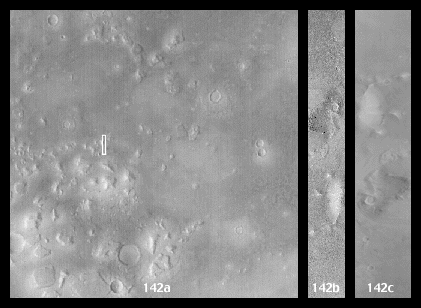
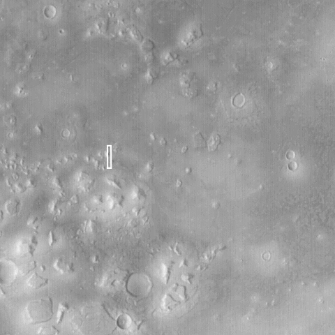
The picture at the above left (MOC2-142a) shows the regional context. Cydonia constitutes a transition zone between the cratered highlands of Arabia Terra, and the less-cratered lowlands of Acidalia Planitia. This transition zone contains thousands of mesas and buttes--somewhat like the Monument Valley region along the Arizona/Utah border in North America. The white box shows the location of the new high resolution view of the "city" landforms. The image is a red wide angle context frame obtained by MOC at the same time that the high resolution view was acquired. The picture is illuminated from the lower left, and north is toward the upper right.
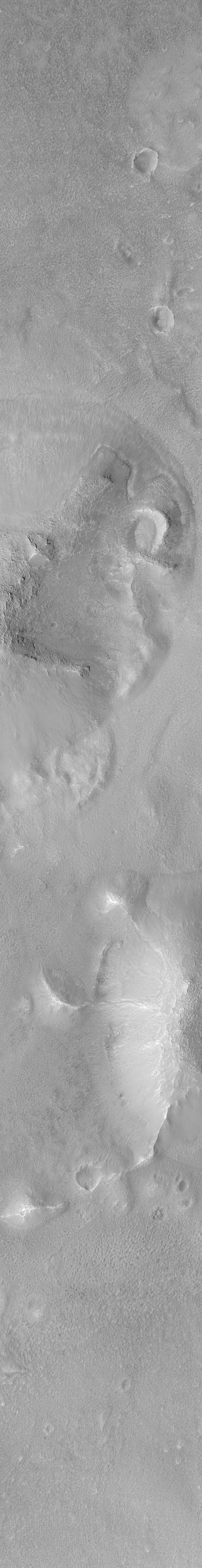
The picture in the center is a processed version of the new MOC narrow angle camera image of this portion of Cydonia. You can view the full-size image (MOC2-142b 100% Size).
Like the context image (above left), the high resolution view (center) is illuminated from the lower left. North is toward the upper right. Boulders can be seen on some of the hill slopes, and the plains between the hills are rough and pitted. To conserve data in order to account for downtrack position uncertainties, only 1/2 of the MOC sensor was used to acquire this picture (allowing the image to be twice the length): it covers an area that is 1.5 km (0.9 mi) wide.
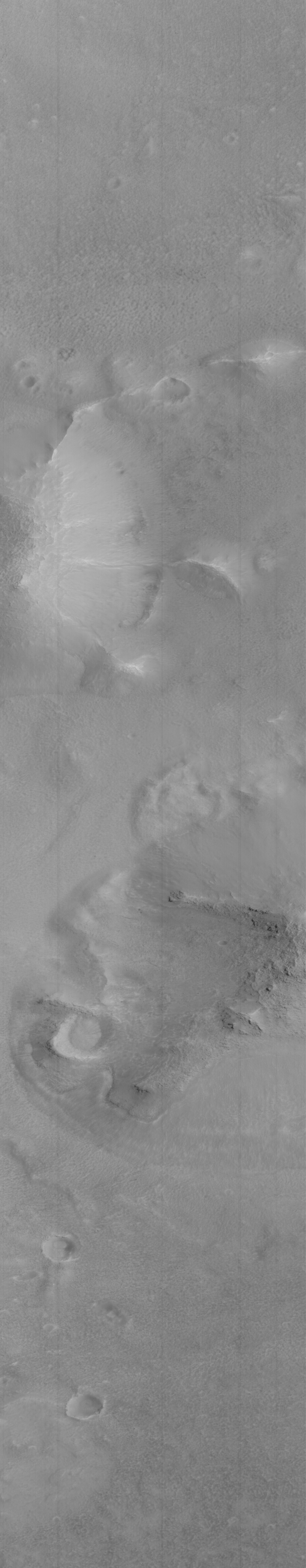
The picture at the above right is the unprocessed MOC image. This what the processed image (center) looked like before it was rotated 180° (so that north is toward the top) and corrected for a 1.5 aspect ratio. The pixel size in the unprocessed image is different in the cross-track (left-right) and down-track (top-bottom) directions, thus making the craters look "squished." The cross-track scale is about 1.5 meters (5 feet) per pixel, while the down-track scale is about 2.25 meters (7.4 feet) per pixel. In the unprocessed image, the illumination is coming from the upper right. You can view this image at full-size (use "Save this link as..." and examine (MOC2-142c 100% Size) or see it via your web-browser at half-size (MOC2-142c 50% Size).
For a pre-MGS discussion of Viking orbiter images of the "Face on Mars," CLICK HERE.
Malin Space Science Systems and the California Institute of Technology built the MOC using spare hardware from the Mars Observer mission. MSSS operates the camera from its facilities in San Diego, CA. The Jet Propulsion Laboratory's Mars Surveyor Operations Project operates the Mars Global Surveyor spacecraft with its industrial partner, Lockheed Martin Astronautics, from facilities in Pasadena, CA and Denver, CO.
 Planetary Data System


