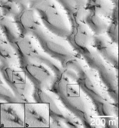
The first time that the Mars Global Surveyor (MGS) Mars Orbiter Camera (MOC) team saw dark spots on defrosting dune surfaces was in August and September of 1998. At that time, it was the north polar seasonal frost cap that was subliming away (more recent images from 1999 have shown the south polar frosts). This picture (above) shows a small portion of the giant dune field that surrounds the north polar region, as it appeared on August 23, 1998. At the time, it was early northern spring and the dunes were still covered with winter frost.
Dark spots had appeared on the north polar dunes, and many of them exhibited a radial or semi-radial pattern of dark streaks and streamers. At first, there was speculation that the streaks indicated that the defrosting process might somehow involve explosions! The dark spots seemed to resemble small craters with dark, radial ejecta. It seemed possible that frozen carbon dioxide trapped beneath water ice might somehow heat up, turn to gas, expand, and then "explode" in either a small blast or at least a "puff" of air similar to that which comes from the blowhole of a surfacing whale or seal.
The image shown here changed the earlier impression. The dark spots and streaks do not result from explosions. The spots--though not well understood--represent the earliest stages of defrosting on the sand dunes. The streaks, instead of being caused by small explosions, are instead the result of wind. In this picture, the fine, dark streaks show essentially identical orientations from spot to spot (e.g., compare the spots seen in boxes (a) and (b)). Each ray of dark material must result from wind blowing from a particular direction--for example, all of the spots in this picture exhibit a ray that points toward the upper left corner of the image, and each of these rays indicates the same wind regime. Each spot also has a ray pointing toward the lower right and top/upper-right. These, too, must indicate periods when the wind was strong enough to move materials, consistently, in only one direction.
The sand that makes up the north polar dunes is dark. Each spot and streak is composed of the dune sand. The bright surfaces are all covered with frost. This picture is located near 76.9°N, 271.2°W, in the north polar sand sea. Illumination is from the lower left. The 200 meter scale also indicates a distance of 656 feet.
Malin Space Science Systems and the California Institute of Technology built the MOC using spare hardware from the Mars Observer mission. MSSS operates the camera from its facilities in San Diego, CA. The Jet Propulsion Laboratory's Mars Surveyor Operations Project operates the Mars Global Surveyor spacecraft with its industrial partner, Lockheed Martin Astronautics, from facilities in Pasadena, CA and Denver, CO.

 Planetary Data System


