PDS logoPlanetary Data System
PDS Information
Find a Node - Use these links to navigate to any of the 8 publicly accessible PDS Nodes.

This bar indicates that you are within the PDS enterprise which includes 6 science discipline nodes and 2 support nodes which are overseen by the Project Management Office at NASA's Goddard Space Flight Center (GSFC). Each node is led by an expert in the subject discipline, supported by an advisory group of other practitioners of that discipline, and subject to selection and approval under a regular NASA Research Announcement.
Click here to return to the Photojournal Home Page Click here to view a list of Photojournal Image Galleries Photojournal_inner_header
Latest Images  |  Spacecraft & Technology  |  Animations  |  Space Images App  |  Feedback  |  Photojournal Search  

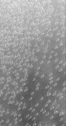
PIA02339: Autumn Frost, North Polar Sand Dunes
 Target Name:  Mars
 Is a satellite of:  Sol (our sun)
 Mission:  Mars Global Surveyor (MGS)
 Spacecraft:  Mars Global Surveyor Orbiter
 Instrument:  Mars Orbiter Camera (MOC)
 Product Size:  418 x 802 pixels (w x h)
 Produced By:  Malin Space Science Systems
 Producer ID:  MOC2-184 MRPS95343 P50602
 Addition Date:  2000-05-13
 Primary Data Set:  MGS EDRs
 Full-Res TIFF:  PIA02339.tif (267.1 kB)
 Full-Res JPEG:  PIA02339.jpg (70.98 kB)

Click on the image above to download a moderately sized image in JPEG format (possibly reduced in size from original)

Original Caption Released with Image:

Autumn in the martian northern hemisphere began around August 1, 1999. Almost as soon as northern fall began, the Mars Global Surveyor (MGS) Mars Orbiter Camera (MOC) started documenting the arrival of autumn frost--a precursor to the cold winter that will arrive in late December 1999. The first features to become covered by frost were the sand dunes that surround the north polar ice cap. The dunes seen here would normally appear very dark--almost black--except when covered by frost. Why the dunes begin to frost sooner than the surrounding surfaces is a mystery: perhaps the dunes contain water vapor that emerges from the sand during the day and condenses again at night. This picture shows dunes near 74.7°N, 61.4°W at a resolution of about 7.3 meters (24 feet) per pixel. The area covered is about 3 km (1.9 mi) across and is illuminated from the upper right. The picture appears to be somewhat fuzzy and grainy because the dunes here are seen through the thin haze of the gathering north polar winter hood (i.e., clouds).

Image Credit:
NASA/JPL/MSSS

Image Addition Date:
2000-05-13