My
List |
Addition Date
|
Target
|
Mission
|
Instrument
|
Size
|

|
2005-09-26 |
Earth
|
Jason-1
|
Altimeter
|
658x551x3 |
|
-
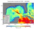
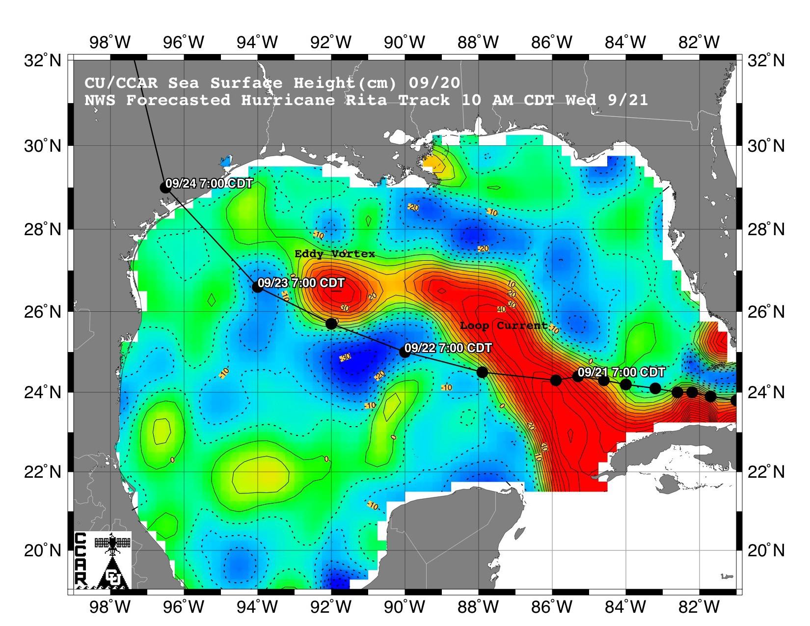
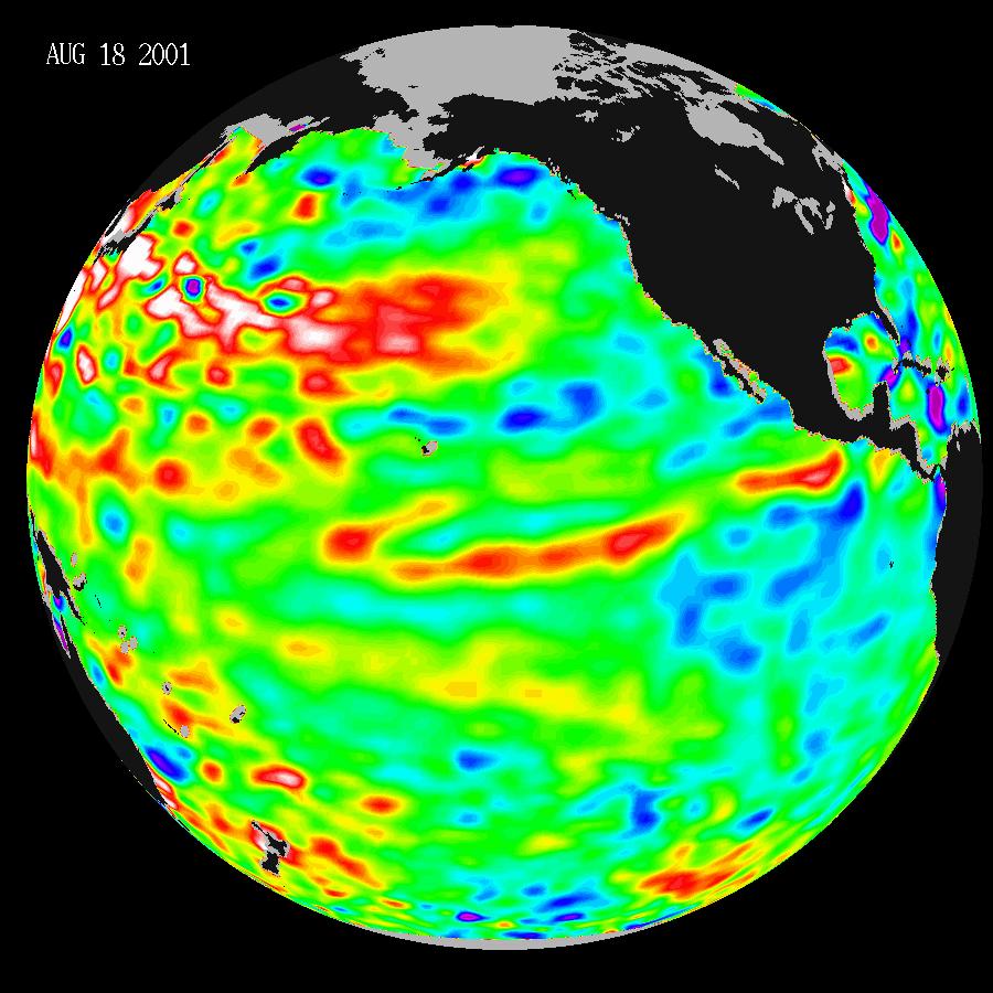
PIA06342:
-
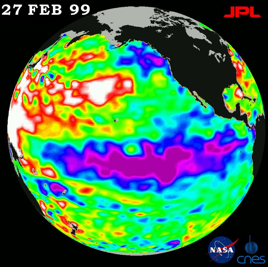
NASA Data Helps Track Heat Potential Fueling Rita
Full Resolution:
TIFF
(1.089 MB)
JPEG
(60.83 kB)
|
|
|
2005-09-22 |
Earth
|
Jason-1
|
Altimeter
|
825x638x3 |
|
-
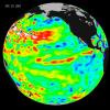
PIA06427:
-
Rita Roars Through a Warm Gulf (September 22, 2005)
Full Resolution:
TIFF
(1.581 MB)
JPEG
(106.3 kB)
|
|
|
2005-09-21 |
Earth
|
Jason-1
|
Altimeter
|
1650x1275x3 |

|
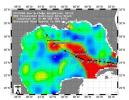
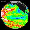
-
PIA06428:
-
Rita Roars Through a Warm Gulf (September 21, 2005)
Full Resolution:
TIFF
(6.322 MB)
JPEG
(304.7 kB)
|
|
|
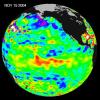
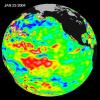
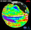
2005-03-14 |
Earth
|
Jason-1
|
Altimeter
|
900x900x3 |
|
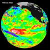
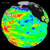
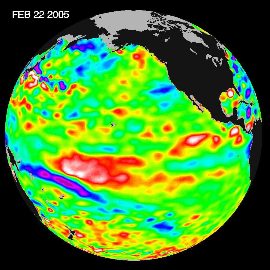
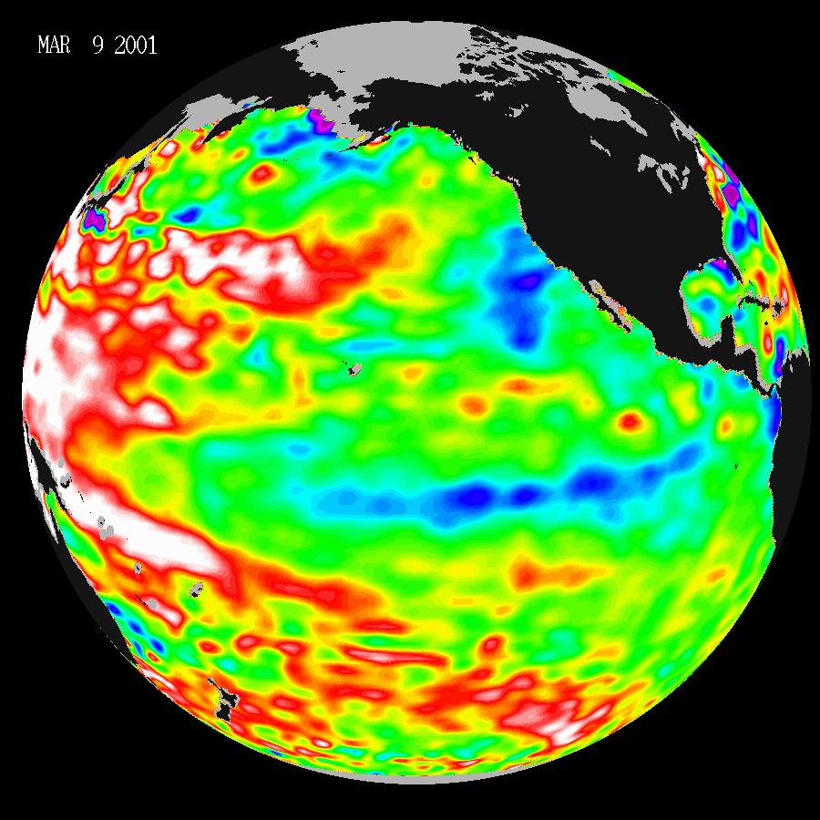
-
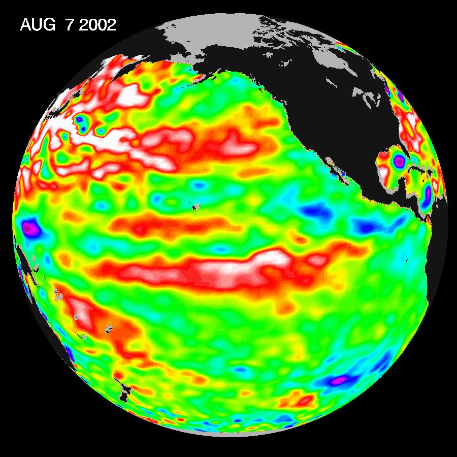
PIA07456:
-
El Niño: The Weak, Getting Weaker
Full Resolution:
TIFF
(1.554 MB)
JPEG
(116.5 kB)
|
|
|
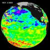
2005-01-12 |
Earth
|
Jason-1
|
Altimeter
|
1590x1800x3 |
|
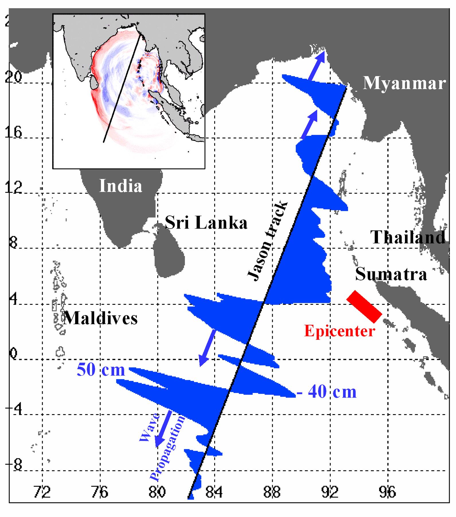
-
PIA07219:
-
NASA/French Satellite Data Reveal New Details of Tsunami
Full Resolution:
TIFF
(1.269 MB)
JPEG
(280 kB)
|
|
|
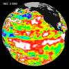
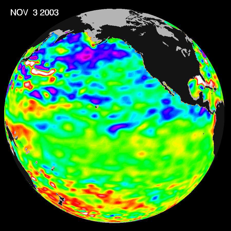
2004-11-16 |
Earth
|
Jason-1
|
Altimeter
|
900x900x3 |
|
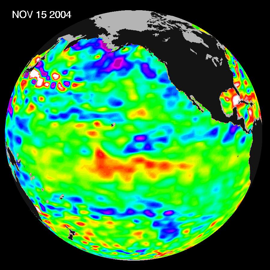
-
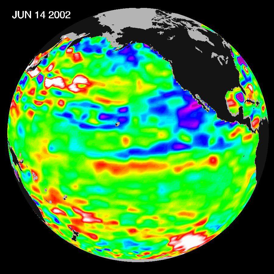
PIA05078:
-
El Nino: Pumping Up or Fizzling Out?
Full Resolution:
TIFF
(1.575 MB)
JPEG
(116.1 kB)
|
|
|
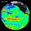
2004-08-04 |
Earth
|
Jason-1
|
Altimeter
|
900x900x3 |
|
-
PIA06751:
-
Warm Pacific Water Wave Heads East, But No El Niño Yet
Full Resolution:
TIFF
(2.438 MB)
JPEG
(110.9 kB)
|
|
|
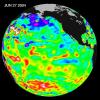
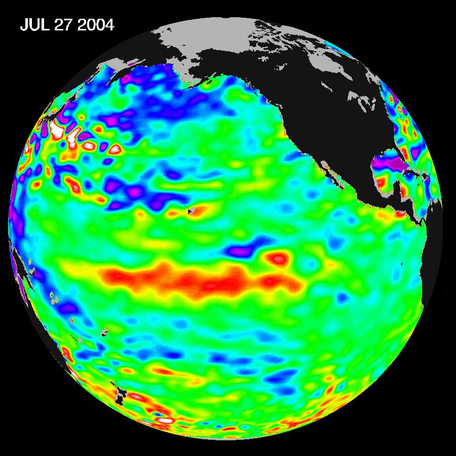
2004-07-13 |
Earth
|
Jason-1
|
Altimeter
|
900x900x3 |
|
-
PIA06381:
-
Pacific Decadal Oscillation Influences Drought (June 27, 2004)
Full Resolution:
TIFF
(2.433 MB)
JPEG
(115.5 kB)
|
|
|
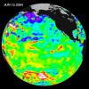
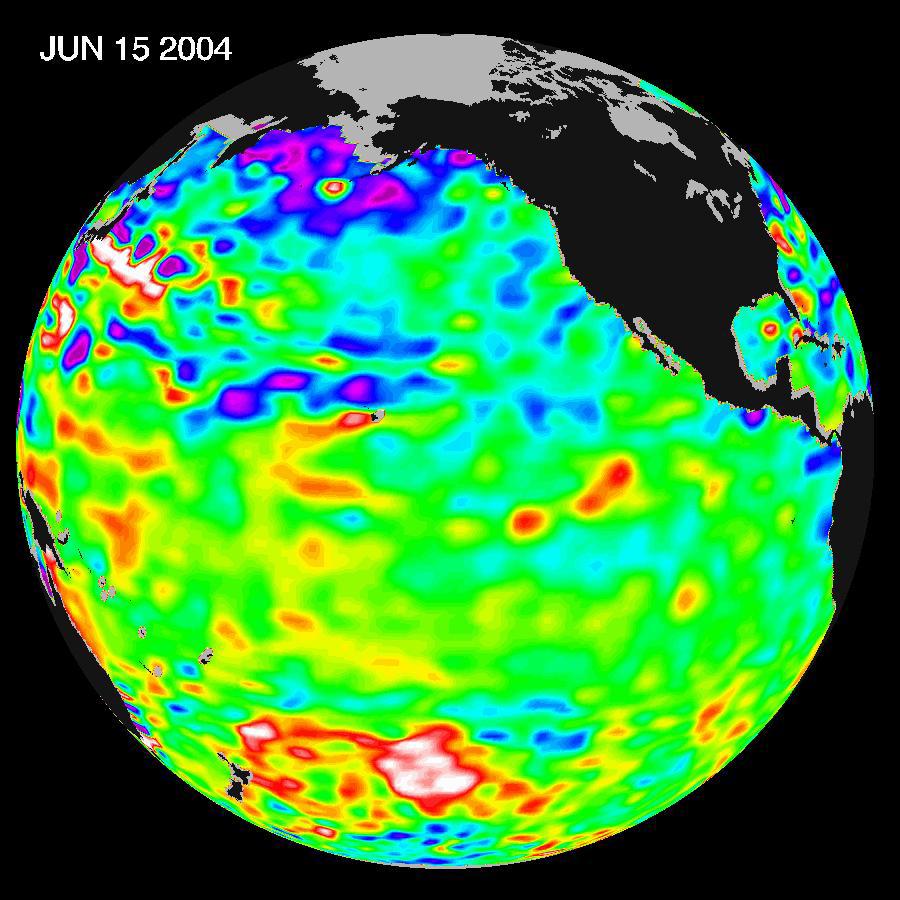
2004-07-13 |
Earth
|
Jason-1
|
Altimeter
|
900x900x3 |
|
-
PIA06380:
-
Pacific Decadal Oscillation Influences Drought (June 15, 2004)
Full Resolution:
TIFF
(2.433 MB)
JPEG
(114.2 kB)
|
|
|
2004-01-30 |
Earth
|
Jason-1
|
Altimeter
|
640x640x3 |
|
-
PIA05071:
-
Pacific Dictates Droughts and Drenchings
Full Resolution:
TIFF
(904.6 kB)
JPEG
(59.93 kB)
|
|
|
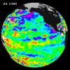
2003-11-18 |
Earth
|
Jason-1
|
Altimeter
|
900x900x3 |
|
-
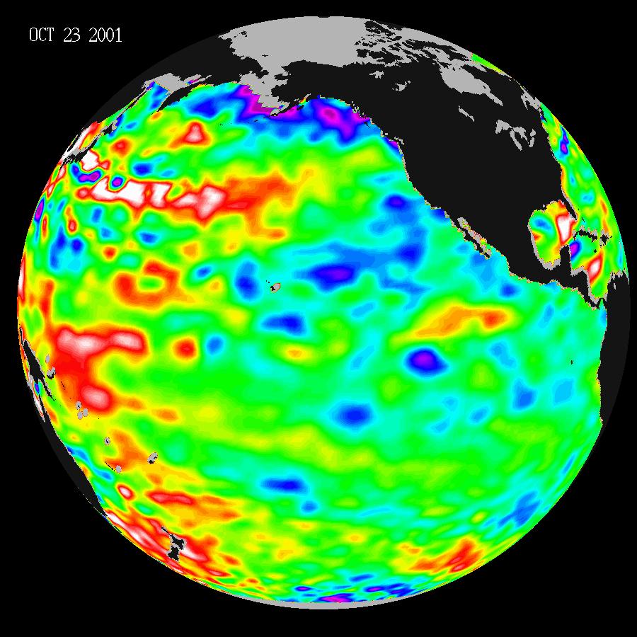
PIA04878:
-
A Mostly Quiet Pacific
Full Resolution:
TIFF
(1.523 MB)
JPEG
(113.4 kB)
|
|
|
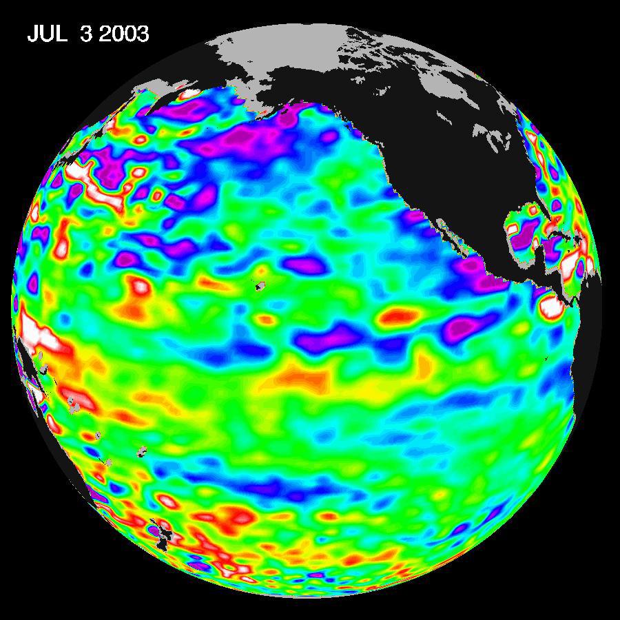
2003-07-14 |
Earth
|
Jason-1
|
Altimeter
|
900x900x3 |
|
-
PIA04622:
-
Where is La Niña?
Full Resolution:
TIFF
(1.557 MB)
JPEG
(123.3 kB)
|
|
|
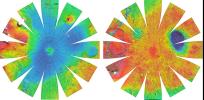
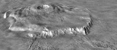
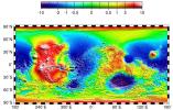
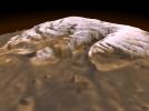
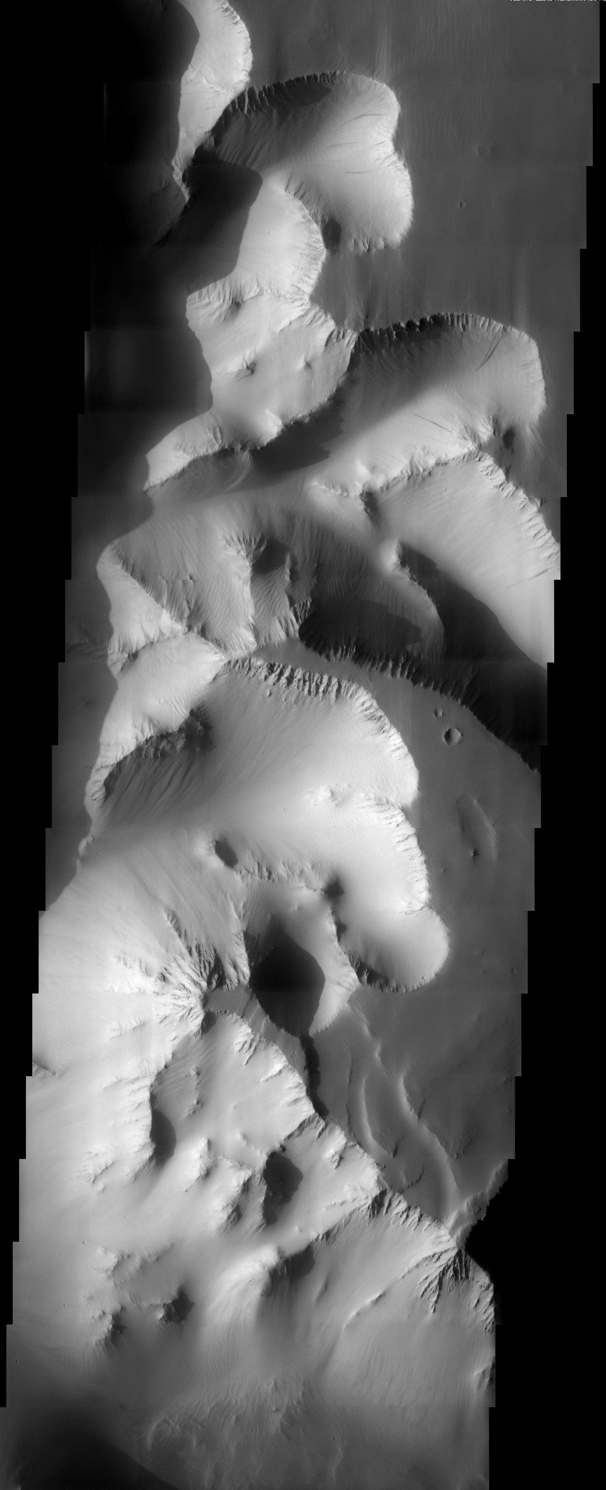
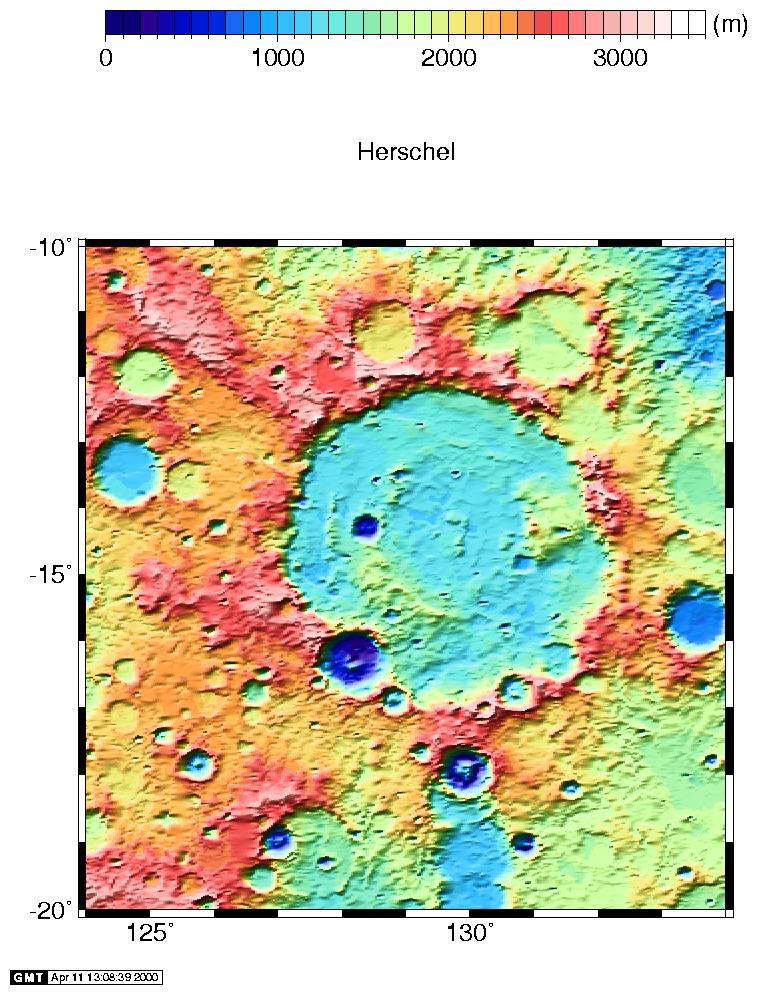
2003-06-17 |
Mars
|
2001 Mars Odyssey
|
MOLA
Thermal Emission Imaging System
|
1239x3043x1 |

|
-
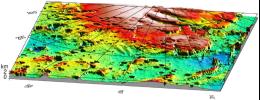
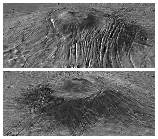
PIA04577:
-
Canyon Walls
Full Resolution:
TIFF
(2.865 MB)
JPEG
(287.6 kB)
|
|
|
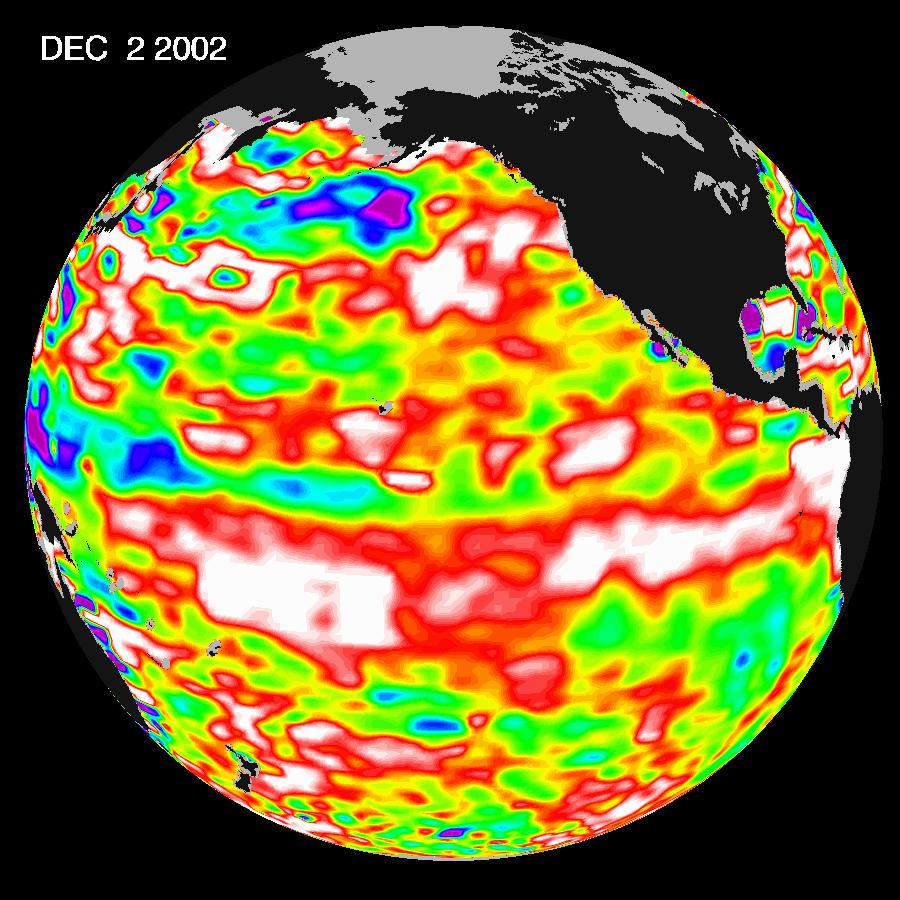
2002-12-12 |
Earth
|
Jason-1
|
Altimeter
|
900x900x3 |
|
-
PIA03889:
-
El Niño Continues to Grow
Full Resolution:
TIFF
(2.439 MB)
JPEG
(136.2 kB)
|
|
|
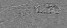
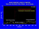
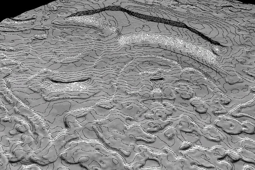
2002-10-10 |
Mars
|
Mars Global Surveyor (MGS)
|
Mars Orbiter Camera (MOC)
Mars Orbiter Laser Altimeter
|
879x585x3 |
|
-
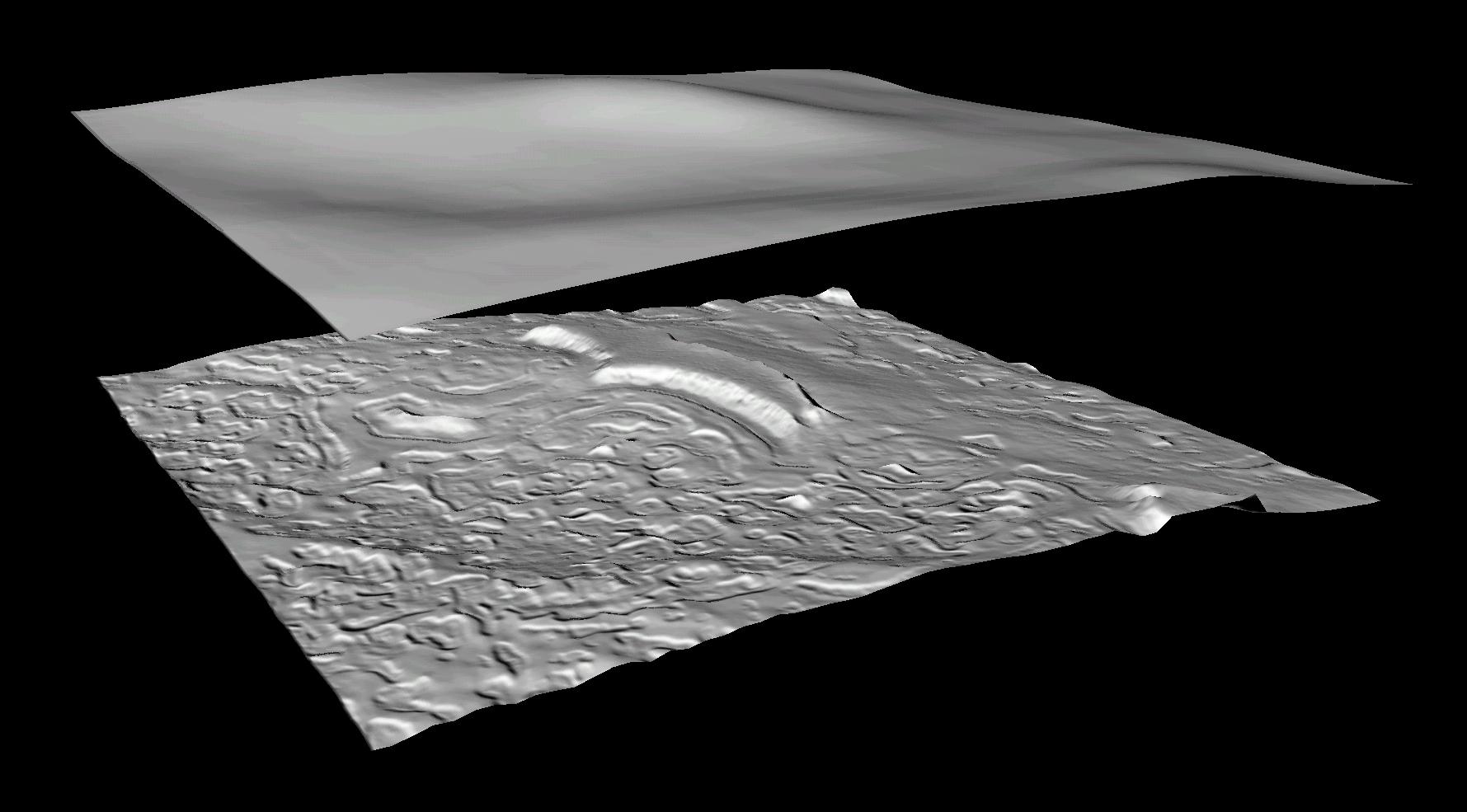
PIA03874:
-
Derived Topographic Model from Mars Global Surveyor Instruments
Full Resolution:
TIFF
(1.123 MB)
JPEG
(193.4 kB)
|
|
|
2002-10-10 |
Mars
|
Mars Global Surveyor (MGS)
|
Mars Orbiter Camera (MOC)
Mars Orbiter Laser Altimeter
|
1779x985x3 |
|
-
PIA03873:
-
Derived Topographic Model from Mars Global Surveyor Instruments
Full Resolution:
TIFF
(1.663 MB)
JPEG
(126.1 kB)
|
|
|
2002-08-22 |
Earth
|
TOPEX/Poseidon
|
Altimeter
|
900x900x3 |
|
-
PIA03855:
-
Watching for the Next El Niño
Full Resolution:
TIFF
(171.5 kB)
JPEG
(116.4 kB)
|
|
|
2002-07-03 |
Earth
|
TOPEX/Poseidon
|
Altimeter
|
900x900x3 |
|
-
PIA03850:
-
Pacific Ocean in Holding Pattern for El Niño
Full Resolution:
TIFF
(1.608 MB)
JPEG
(124 kB)
|
|
|
2001-11-07 |
Earth
|
TOPEX/Poseidon
|
Altimeter
|
900x900x3 |
|
-
PIA03460:
-
Pacific Decadal Oscillation
Full Resolution:
TIFF
(175.7 kB)
JPEG
(111.9 kB)
|
|
|
2001-08-27 |
Earth
|
TOPEX/Poseidon
|
Altimeter
|
900x900x3 |
|
-
PIA03457:
-
Pacific Decadal Oscillation Still Rules in Pacific; No Niño Anytime Soon
Full Resolution:
TIFF
(175.4 kB)
JPEG
(112 kB)
|
|
|
2001-03-28 |
Earth
|
TOPEX/Poseidon
|
Altimeter
|
900x900x3 |
|
-
PIA00556:
-
Warm Ocean Temperatures Blanket the Far-Western Pacific
Full Resolution:
TIFF
(172.2 kB)
JPEG
(116.7 kB)
|
|
|
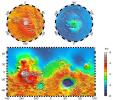
2001-01-17 |
Mars
|
Mars Global Surveyor (MGS)
|
MOLA
|
4000x2769x3 |
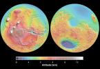
|
-
PIA02820:
-
Mars Topography
Full Resolution:
TIFF
(21.78 MB)
JPEG
(1.109 MB)
|
|
|
2000-11-10 |
Mars
|
Mars Global Surveyor (MGS)
|
MOLA
|
11649x5723x3 |
|
-
PIA02993:
-
Mars Orbiter Laser Altimiter (MOLA) Globe
Full Resolution:
TIFF
(158.6 MB)
JPEG
(11 MB)
|
|
|
2000-10-06 |
Mars
|
Mars Global Surveyor (MGS)
|
MOLA
|
669x441x3 |
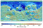
|
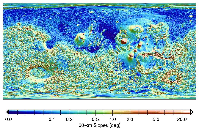
-
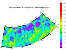
PIA02809:
-
MOLA Global Map of Surface Gradients on Mars
Full Resolution:
TIFF
(254.8 kB)
JPEG
(128.2 kB)
|
|
|
2000-10-06 |
Mars
|
Mars Global Surveyor (MGS)
|
MOLA
|
669x441x3 |
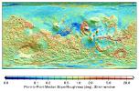
|
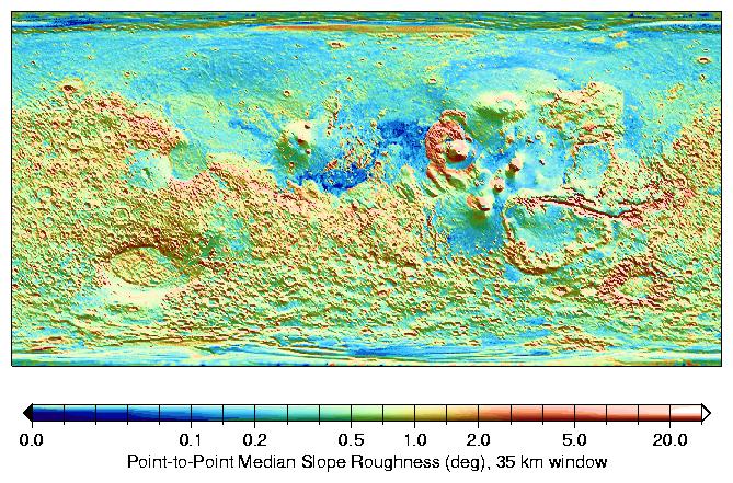
-
PIA02808:
-
MOLA Global Roughness Map of Mars
Full Resolution:
TIFF
(248.3 kB)
JPEG
(114.3 kB)
|
|
|
2000-09-08 |
Mars
|
Mars Global Surveyor (MGS)
|
MOLA
|
757x995x3 |
|
-
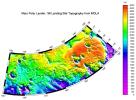
PIA01049:
-
Regional Topographic Views of Mars from MOLA
Full Resolution:
TIFF
(1.717 MB)
JPEG
(157.5 kB)
|
|
|
2000-09-07 |
Mars
|
Mars Global Surveyor (MGS)
|
MOLA
|
2100x900x1 |
|
-
PIA02806:
-
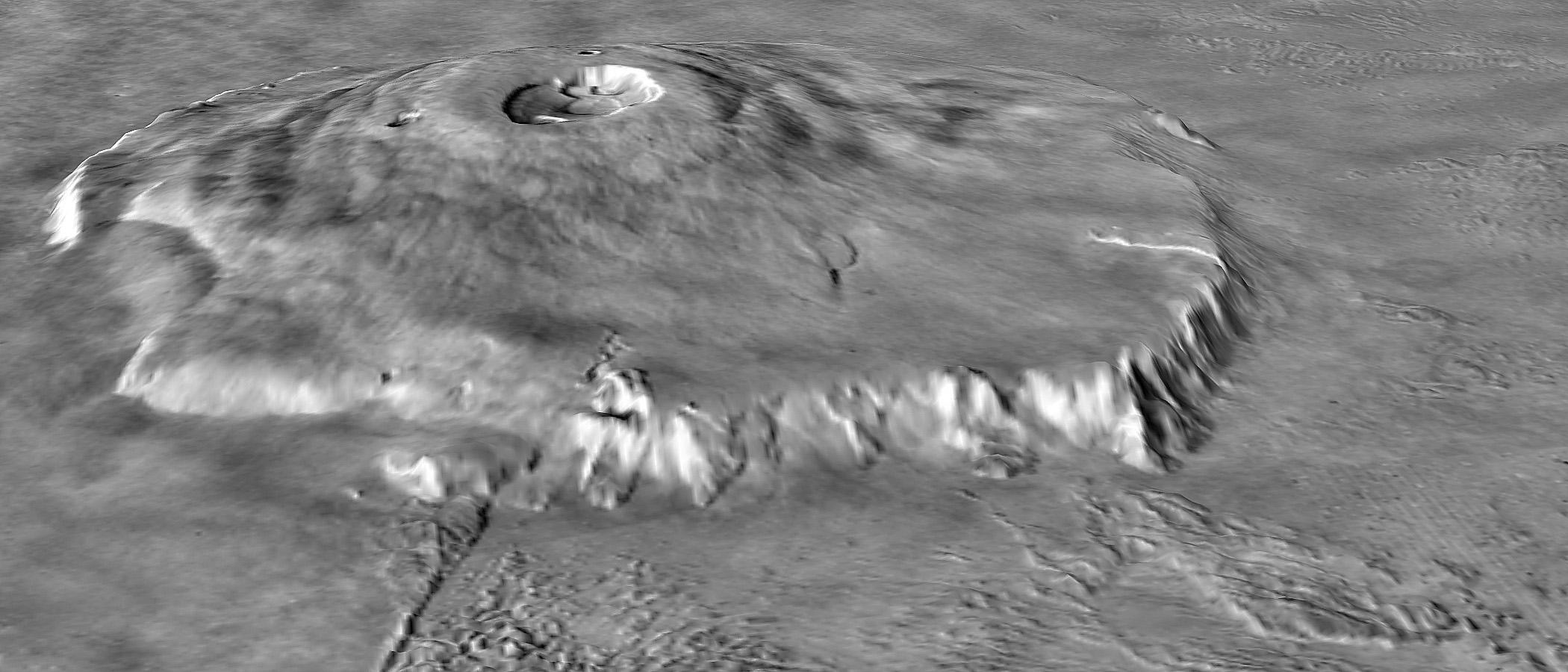
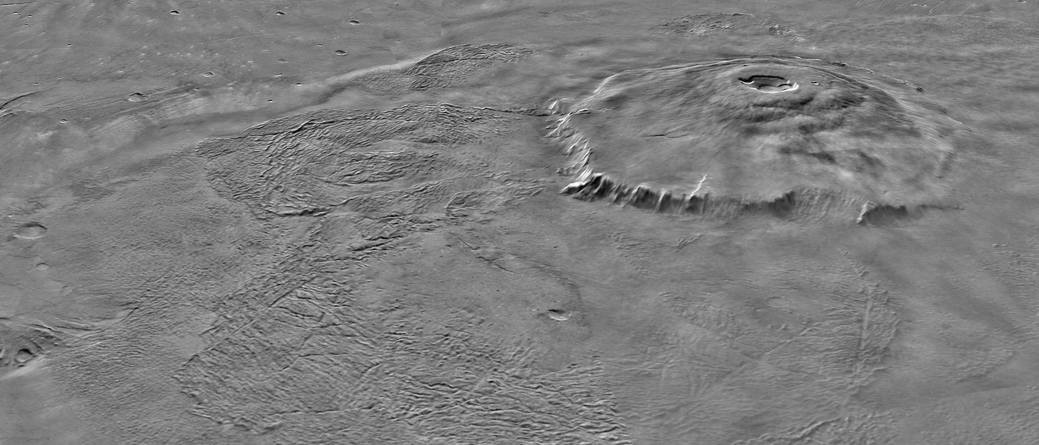
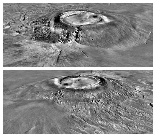
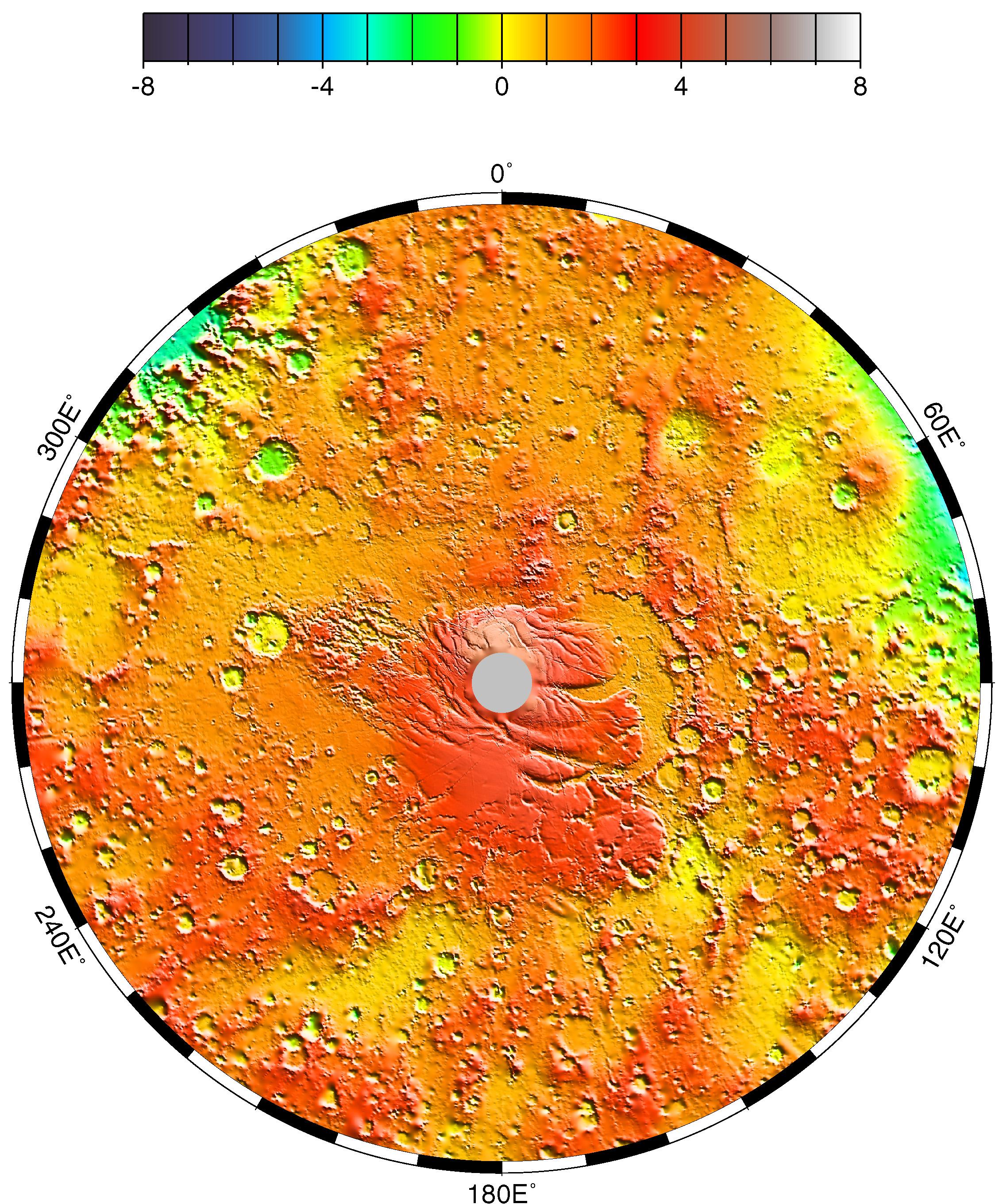
Major Martian Volcanoes from MOLA - Olympus Mons
Full Resolution:
TIFF
(1.451 MB)
JPEG
(205 kB)
|
|
|
2000-09-07 |
Mars
|
Mars Global Surveyor (MGS)
|
MOLA
|
2100x900x1 |
|
-
PIA02805:
-
Major Martian Volcanoes from MOLA - Olympus Mons
Full Resolution:
TIFF
(1.538 MB)
JPEG
(270.9 kB)
|
|
|
2000-09-07 |
Mars
|
Mars Global Surveyor (MGS)
|
MOLA
|
524x462x1 |
|
-
PIA02804:
-
Major Martian Volcanoes from MOLA - Arsia Mons
Full Resolution:
TIFF
(231.1 kB)
JPEG
(52.9 kB)
|
|
|
2000-09-07 |
Mars
|
Mars Global Surveyor (MGS)
|
MOLA
|
524x462x1 |
|
-
PIA02803:
-
Major Martian Volcanoes from MOLA - Alba Patera
Full Resolution:
TIFF
(239.9 kB)
JPEG
(52.87 kB)
|
|
|
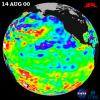
2000-08-30 |
Earth
|
TOPEX/Poseidon
|
Altimeter
|
900x900x3 |
|
-
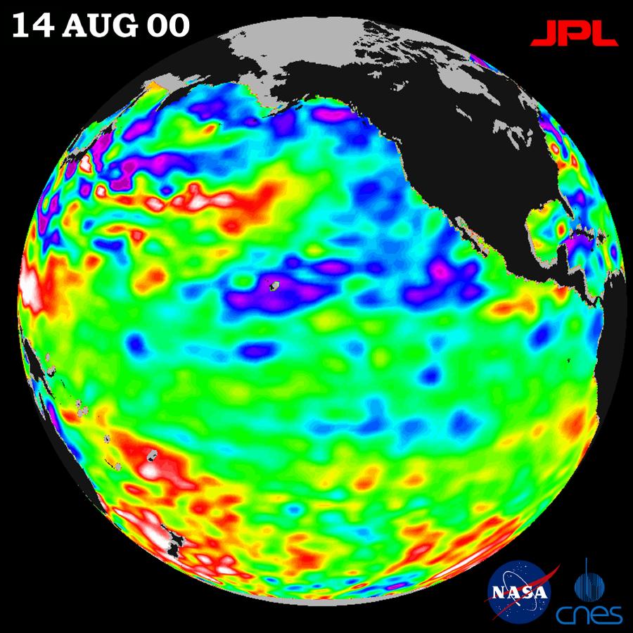
PIA02969:
-
TOPEX/El Niño Watch - Los Niños may be Gone, But Pacific Pattern Remains August 14, 2000
Full Resolution:
TIFF
(983.8 kB)
JPEG
(113.8 kB)
|
|
|
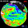
2000-07-06 |
Earth
|
TOPEX/Poseidon
|
Altimeter
|
900x900x3 |
|
-
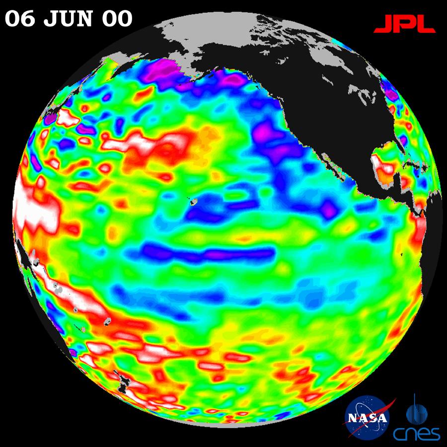
PIA02935:
-
TOPEX/El Niño Watch - Strong, Long-lasting La Niña Just Fading Away, June 19, 2000
Full Resolution:
TIFF
(997.1 kB)
JPEG
(119.1 kB)
|
|
|
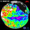
2000-05-07 |
Earth
|
TOPEX/Poseidon
|
Altimeter
|
900x900x3 |
|
-
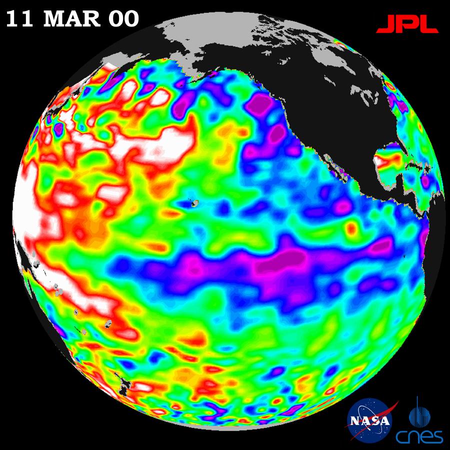
PIA02460:
-
TOPEX/El Niño Watch - La Niña Still a "cool" Problem Child, March 23, 2000
Full Resolution:
TIFF
(1.031 MB)
JPEG
(123.2 kB)
|
|
|
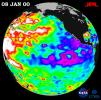
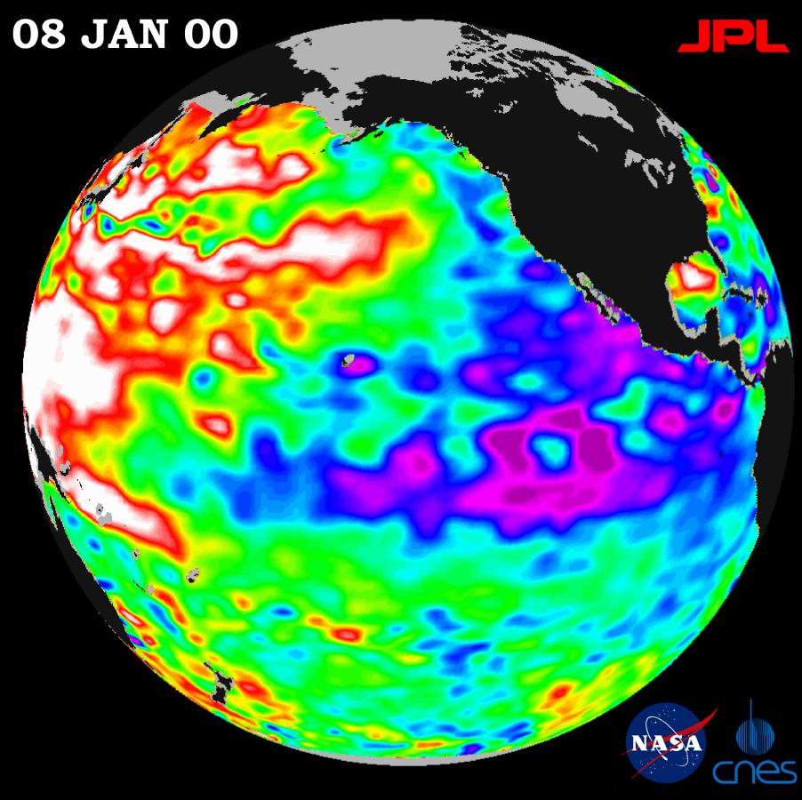
2000-01-21 |
Earth
|
TOPEX/Poseidon
|
Altimeter
|
902x900x3 |
|
-
PIA02448:
-
TOPEX/El Niño Watch - La Niña Persistence May be Part of Larger Climate Pattern, January 8, 2000
Full Resolution:
TIFF
(744.7 kB)
JPEG
(115.1 kB)
|
|
|
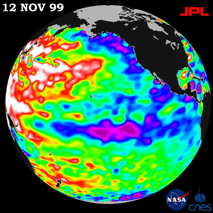
1999-12-01 |
Earth
|
TOPEX/Poseidon
|
Altimeter
|
900x900x3 |
|
-
PIA02437:
-
TOPEX/El Niño Watch - Mild La Niña Conditions Developing, November 12, 1999
Full Resolution:
TIFF
(745.9 kB)
JPEG
(117 kB)
|
|
|
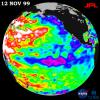
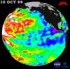
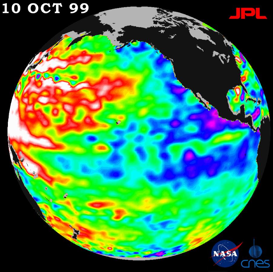
1999-11-18 |
Earth
|
TOPEX/Poseidon
|
Altimeter
|
902x900x3 |
|
-
PIA02436:
-
TOPEX/El Niño Watch - La Niña Conditions Likely to Prevail, October 10, 1999
Full Resolution:
TIFF
(765.6 kB)
JPEG
(113.1 kB)
|
|
|
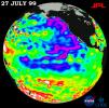
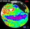
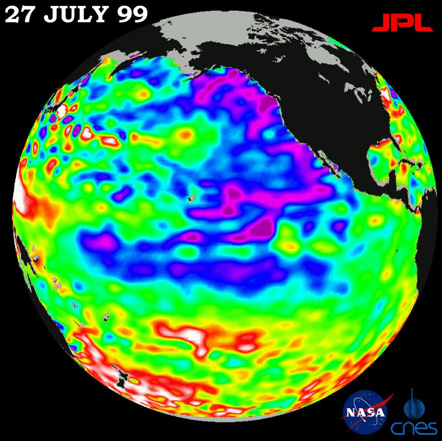
1999-08-23 |
Earth
|
TOPEX/Poseidon
|
Altimeter
|
902x900x3 |
|
-
PIA02403:
-
TOPEX/El Niño Watch - Pacific Ocean Conditions are Split: Cold in East, Hot in West, July 27, 1999
Full Resolution:
TIFF
(872 kB)
JPEG
(116.8 kB)
|
|
|
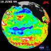
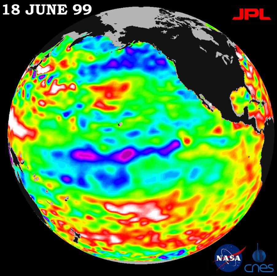
1999-08-23 |
Earth
|
TOPEX/Poseidon
|
Altimeter
|
902x900x3 |
|
-
PIA01586:
-
TOPEX/El Niño Watch - La Niña Barely Has a Pulse, June 18, 1999
Full Resolution:
TIFF
(743.2 kB)
JPEG
(117 kB)
|
|
|
1999-07-06 |
Mars
|
Mars Global Surveyor (MGS)
|
MOLA
|
1280x493x3 |
|
-
PIA02091:
-
Mars '98 Polar landing site
Full Resolution:
TIFF
(1.607 MB)
JPEG
(150 kB)
|
|
|
1999-07-06 |
Mars
|
Mars Global Surveyor (MGS)
|
MOLA
|
910x685x3 |
|
-
PIA02090:
-
MPL LANDING SITE CORRIDOR
Full Resolution:
TIFF
(151.7 kB)
JPEG
(86.71 kB)
|
|
|
1999-07-06 |
Mars
|
Mars Global Surveyor (MGS)
|
MOLA
|
910x670x3 |
|
-
PIA02089:
-
MPL LANDING SITE - DEM
Full Resolution:
TIFF
(172.2 kB)
JPEG
(111.2 kB)
|
|
|
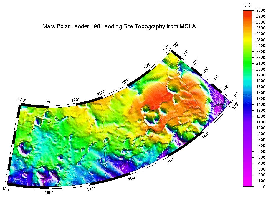
1999-07-06 |
Mars
|
Mars Global Surveyor (MGS)
|
MOLA
|
612x792x3 |
|
-
PIA02088:
-
MOLA TOPOGRAPHIC MAP
Full Resolution:
TIFF
(1.326 MB)
JPEG
(182.1 kB)
|
|
|
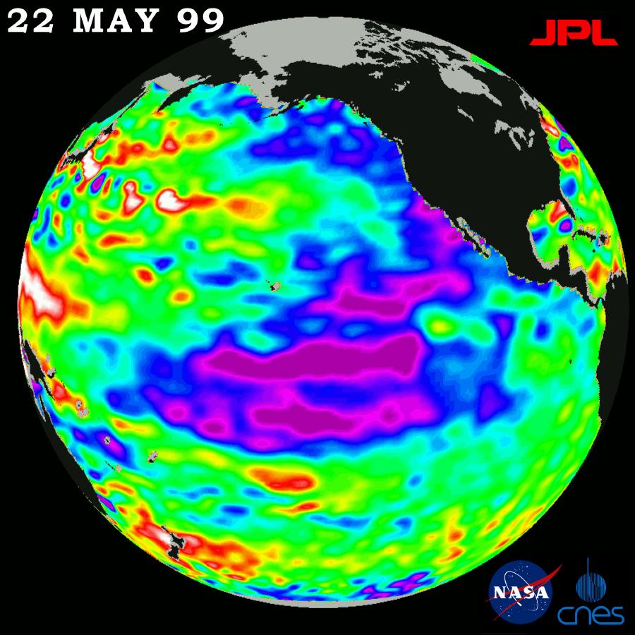
1999-06-23 |
Mars
|
Mars Global Surveyor (MGS)
|
MOLA
|
2468x2592x1 |
|
-
PIA02053:
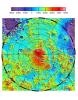
-
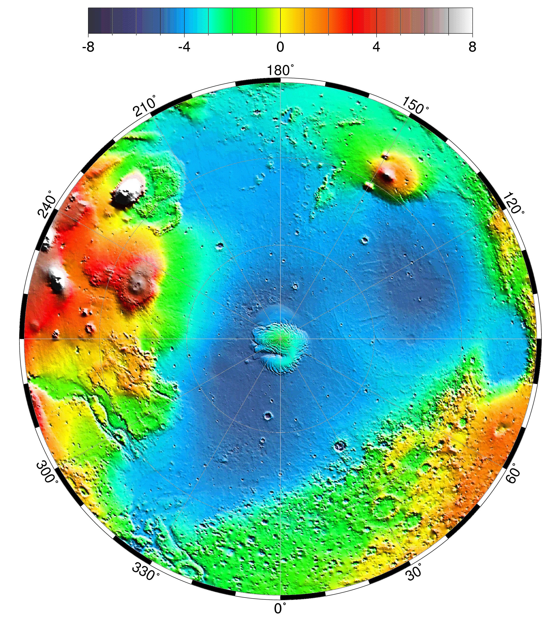
North Polar Topography (MOLA)
Full Resolution:
TIFF
(5.755 MB)
JPEG
(1.378 MB)
|
|
|
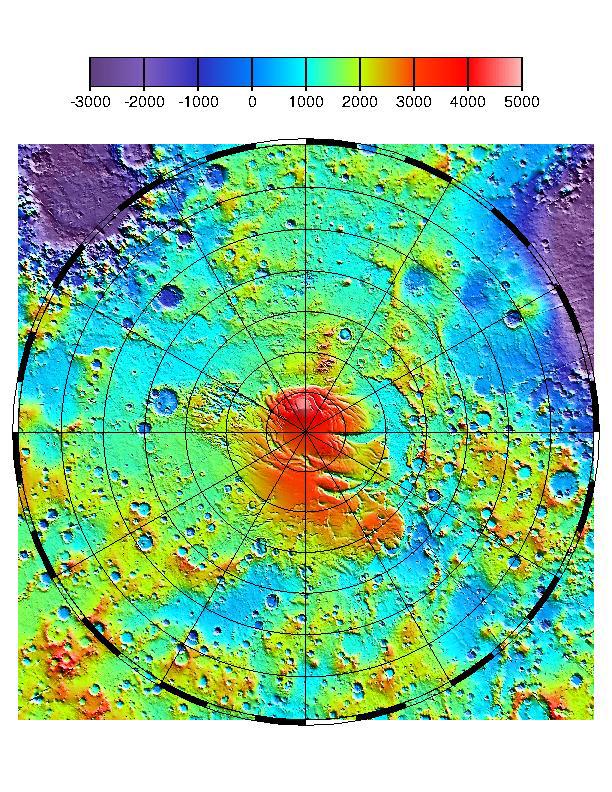
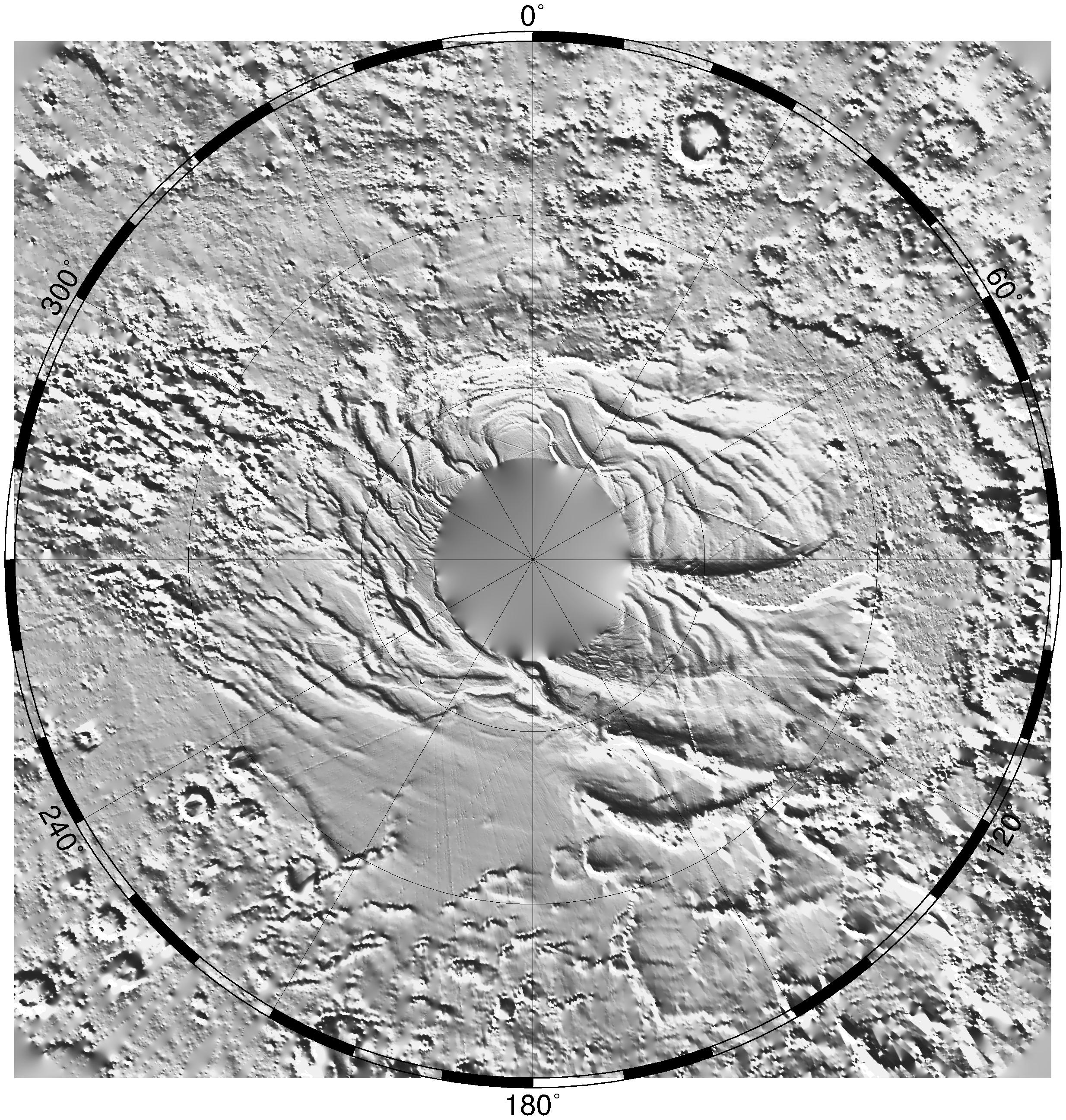
1999-06-23 |
Mars
|
Mars Global Surveyor (MGS)
|
MOLA
|
2468x2592x1 |
|
-
PIA02052:
-
South Polar Topography (MOLA)
Full Resolution:
TIFF
(5.391 MB)
JPEG
(1.241 MB)
|
|
|
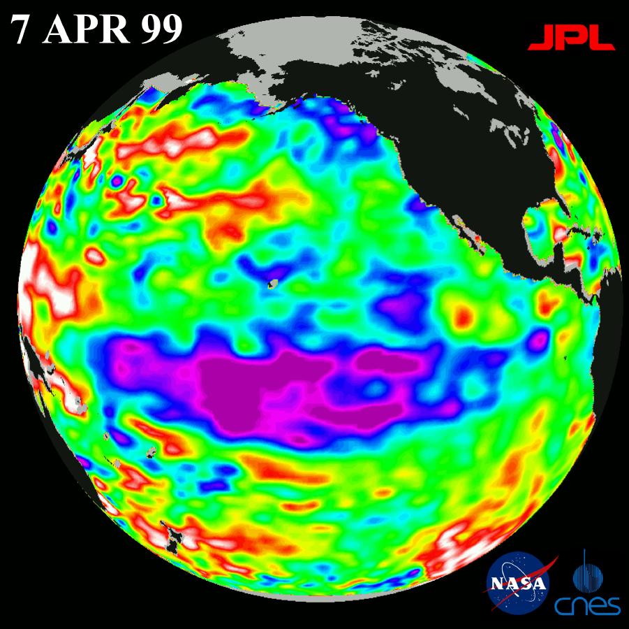
1999-06-21 |
Earth
|
TOPEX/Poseidon
|
Altimeter
|
900x900x3 |
|
-
PIA01528:
-
TOPEX El Niño/La Niña - Entire Pacific is out of Whack, April 7, 1999
Full Resolution:
TIFF
(921.8 kB)
JPEG
(112.1 kB)
|
|
|
1999-06-21 |
Earth
|
TOPEX/Poseidon
|
Altimeter
|
901x900x3 |
|
-
PIA00031:
-
TOPEX El Niño/La Niña -La Niña Begins to Fade, April 7, 1999
Full Resolution:
TIFF
(985.1 kB)
JPEG
(115 kB)
|
|
|
1999-05-27 |
Mars
|
Mars Global Surveyor (MGS)
|
MOLA
|
2700x3075x3 |
|
-
PIA02040:
-
Science Magazine Cover Image
Full Resolution:
TIFF
(12.35 MB)
JPEG
(948.9 kB)
|
|
|
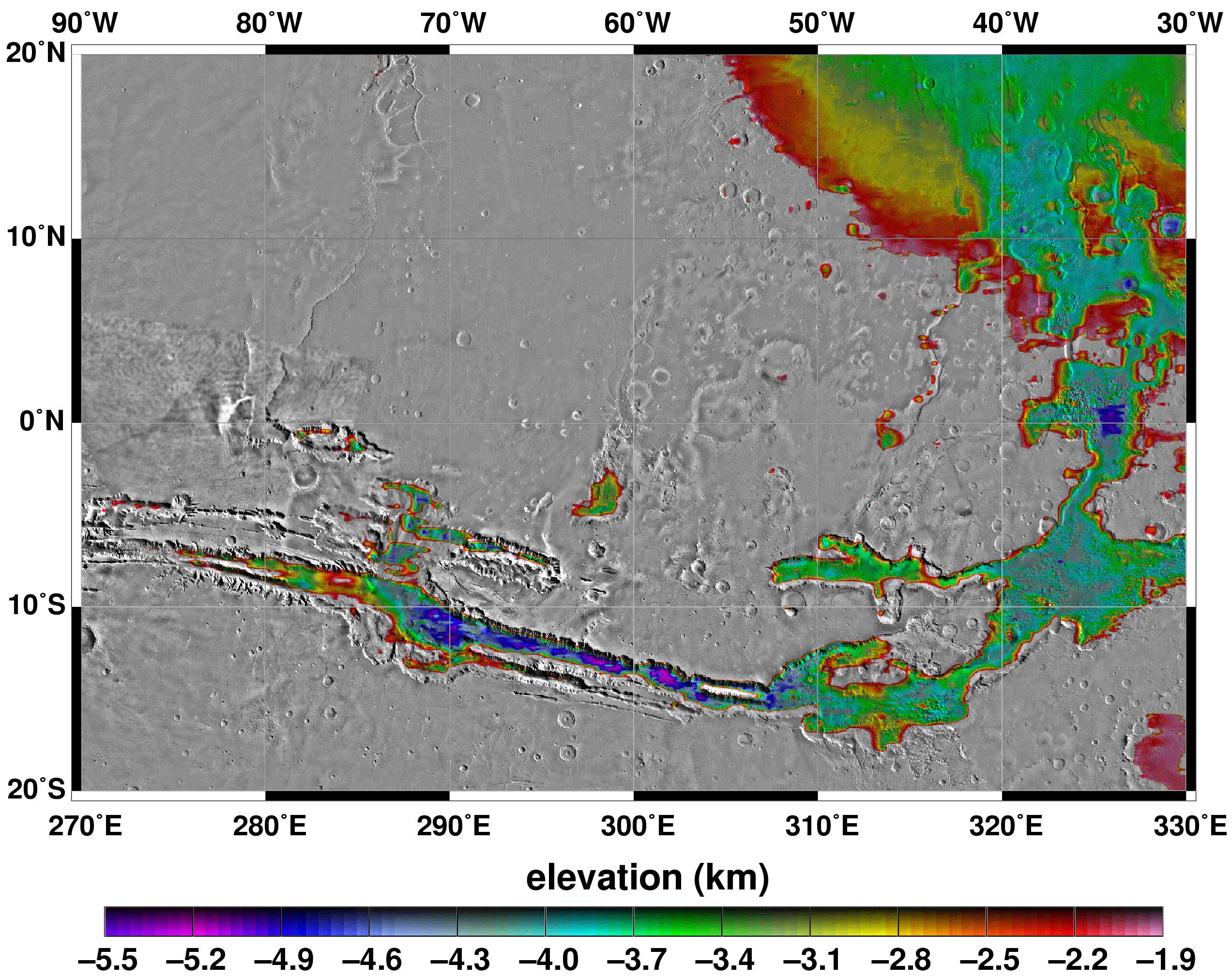
1999-05-27 |
Mars
|
Mars Global Surveyor (MGS)
|
MOLA
|
2545x2023x3 |
|
-
PIA02039:
-
Elevations Within the Floor of the Valles Marineris
Full Resolution:
TIFF
(7.378 MB)
JPEG
(1.035 MB)
|
|
|
1999-05-27 |
Mars
|
Mars Global Surveyor (MGS)
|
MOLA
|
2257x2719x3 |
|
-
PIA02037:
-
Polar Stereographic Projection
Full Resolution:
TIFF
(13.35 MB)
JPEG
(1.042 MB)
|
|
|
1999-05-27 |
Mars
|
Mars Global Surveyor (MGS)
|
MOLA
|
2335x2617x3 |
|
-
PIA02036:
-
Lambert Equal-Area Projection of Pole-to-Equator
Full Resolution:
TIFF
(12.39 MB)
JPEG
(1.28 MB)
|
|
|
1999-05-27 |
Mars
|
Mars Global Surveyor (MGS)
|
MOLA
|
2761x1759x3 |
|
-
PIA02035:
-
Map of Mars' Topography
Full Resolution:
TIFF
(10.08 MB)
JPEG
(1.115 MB)
|
|
|
1999-05-27 |
Mars
|
Mars Global Surveyor (MGS)
|
MOLA
|
1909x2353x3 |
|
-
PIA02033:
-
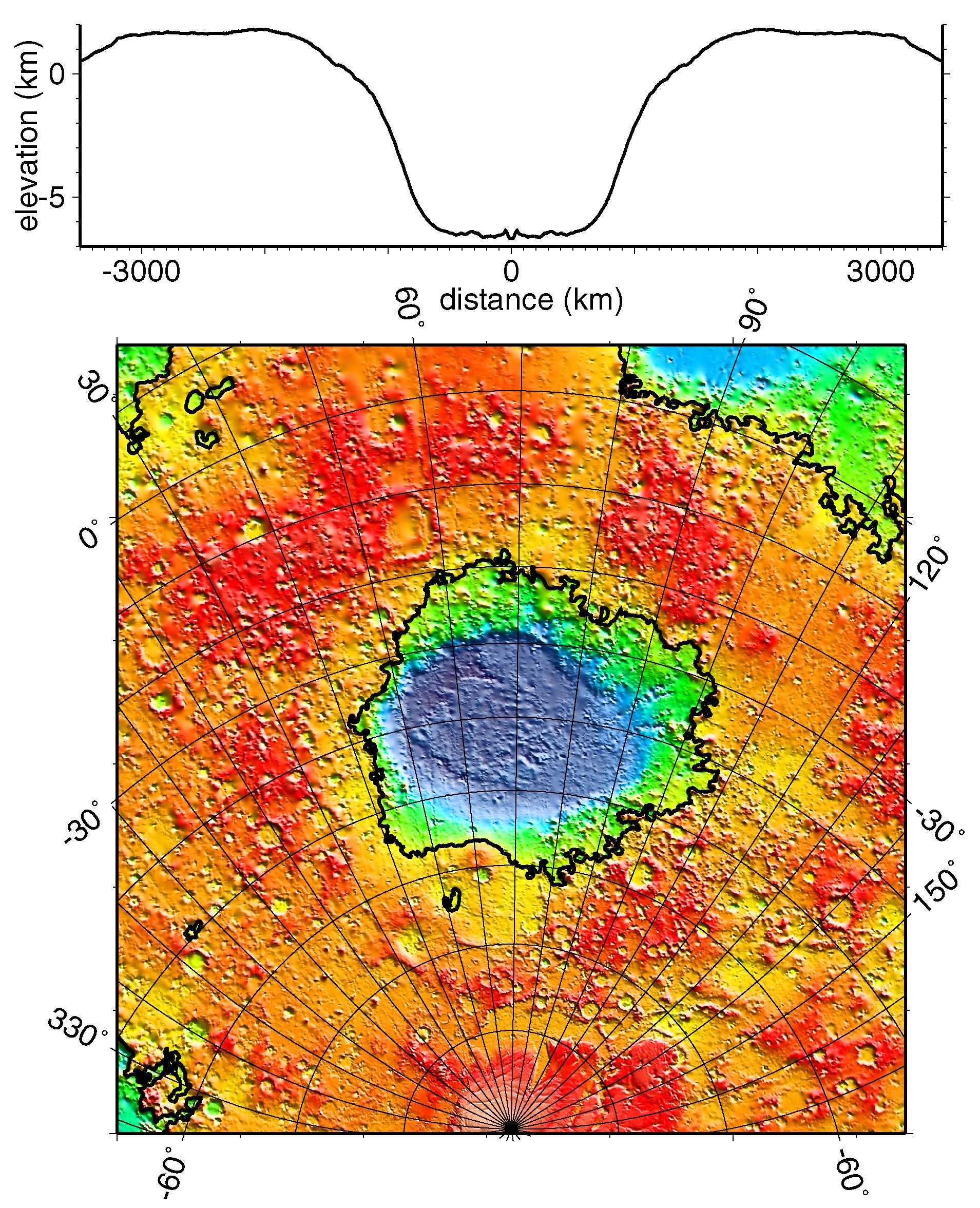
Regional Topographic Model of the Hellas Basin
Full Resolution:
TIFF
(8.461 MB)
JPEG
(901.7 kB)
|
|
|
1999-05-27 |
Mars
|
Mars Global Surveyor (MGS)
|
MOLA
|
2497x2221x3 |
|
-
PIA02031:
-
Maps of Mars Global Topography
Full Resolution:
TIFF
(11.74 MB)
JPEG
(1.145 MB)
|
|
|
1999-04-15 |
Earth
|
TOPEX/Poseidon
|
Altimeter
|
902x900x3 |
|
-
PIA01526:
-
TOPEX/El Niño Watch - La Niña Hangs On, February 27, 1999
Full Resolution:
TIFF
(883.6 kB)
JPEG
(115.5 kB)
|
|
|
1999-04-15 |
Earth
|
TOPEX/Poseidon
|
Altimeter
|
900x900x3 |
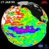
|
-
PIA01525:
-
TOPEX/El Niño Watch - La Niña Weakening, January 17, 1999
Full Resolution:
TIFF
(901.6 kB)
JPEG
(119 kB)
|
|
|
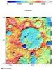
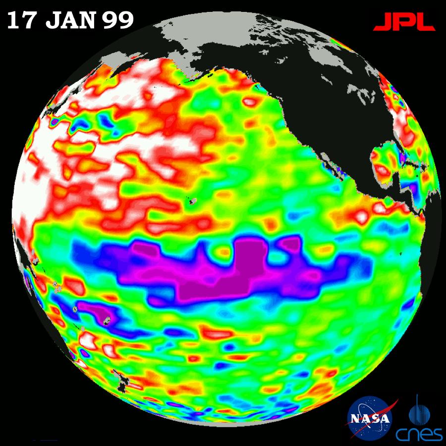
1999-01-07 |
Mars
|
Mars Global Surveyor (MGS)
|
MOLA
|
3042x2292x3 |
|
-
PIA01338:
-
Elevation Measurement Profile of Mars
Full Resolution:
TIFF
(142 kB)
JPEG
(406.8 kB)
|
|
|
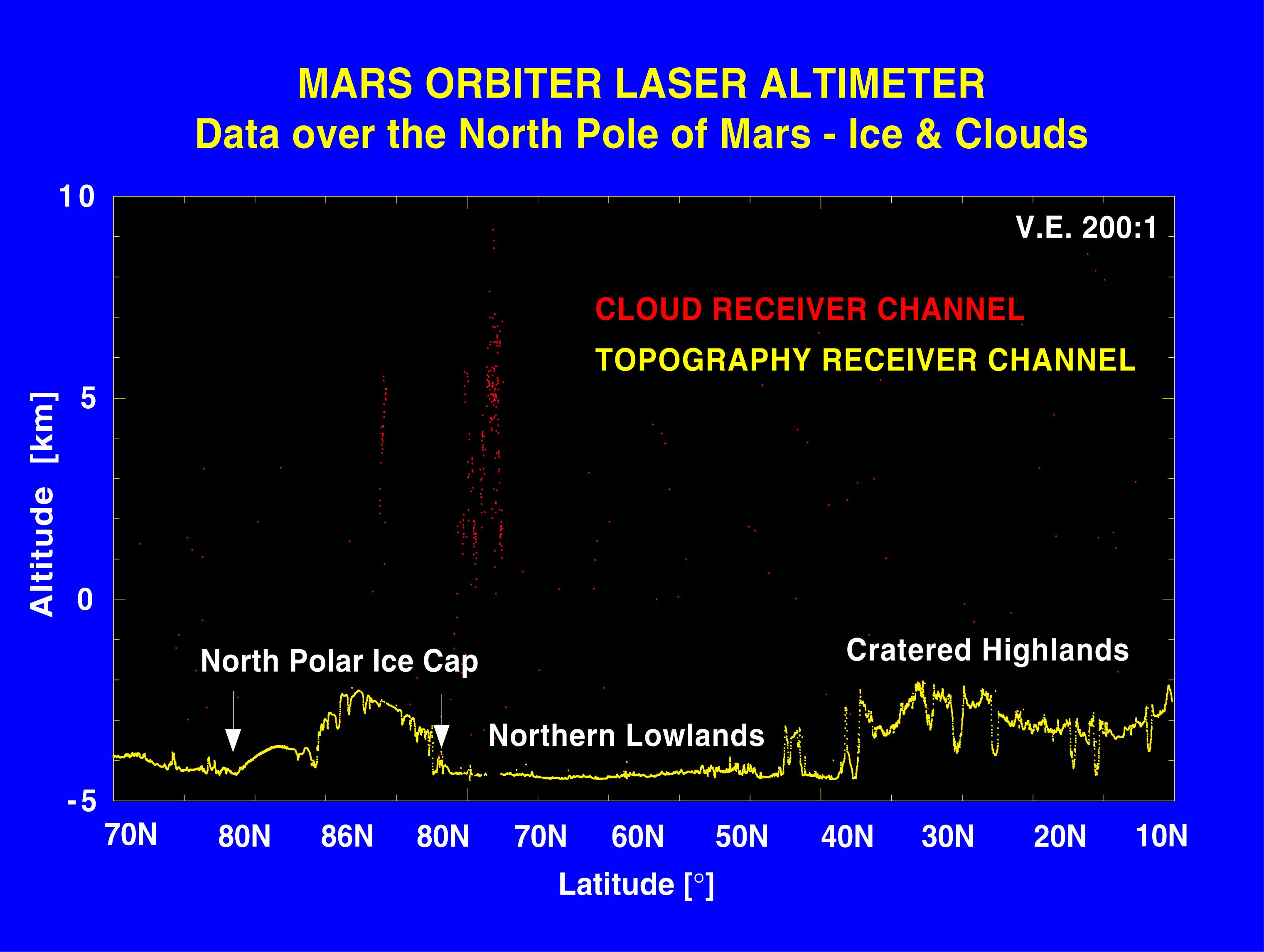
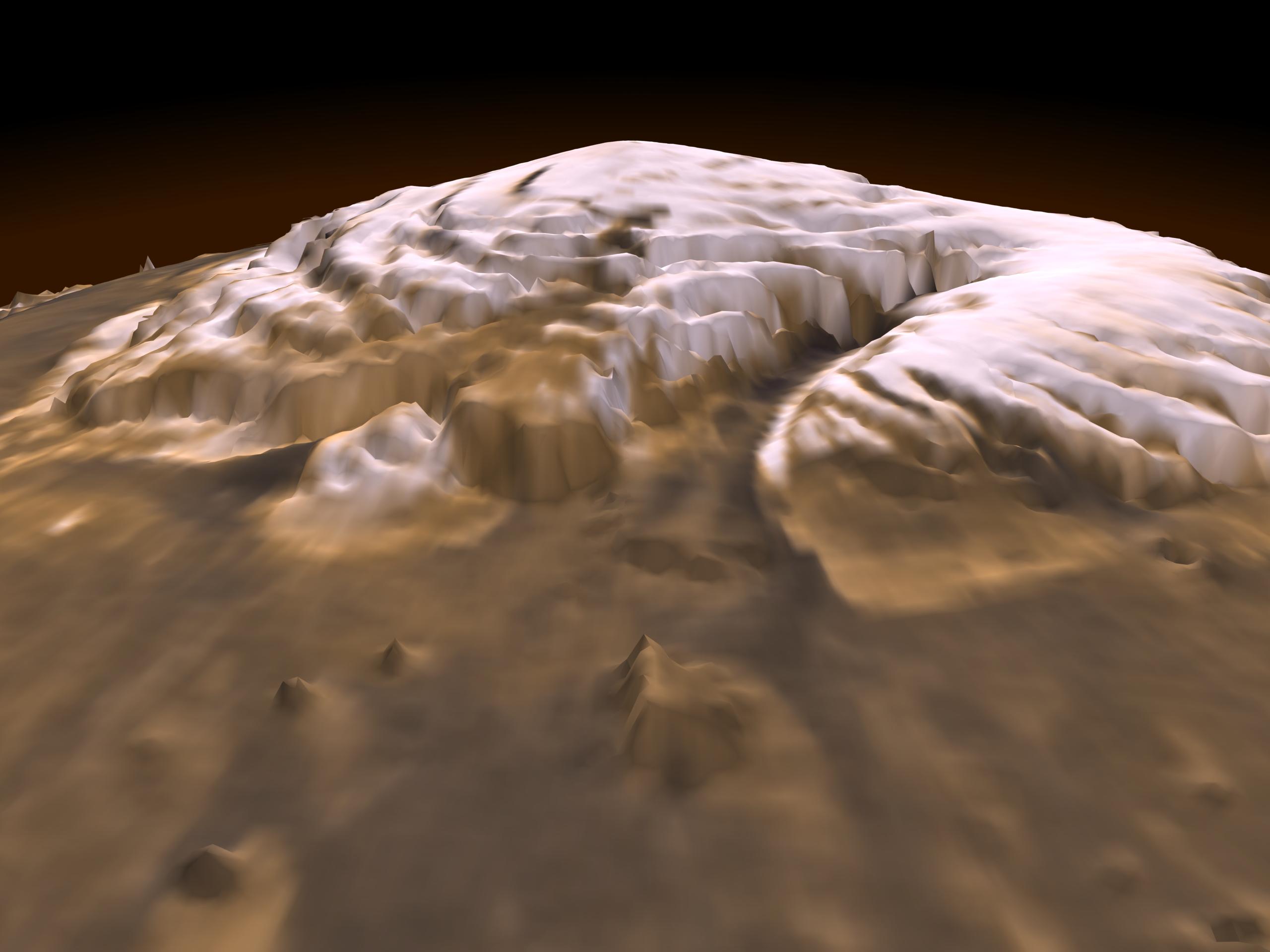
1999-01-07 |
Mars
|
Mars Global Surveyor (MGS)
|
MOLA
|
2560x1920x3 |
|
-
PIA01337:
-
Laser Provides First 3-D View of Mars' North Pole
Full Resolution:
TIFF
(8.414 MB)
JPEG
(200.6 kB)
|
|
|
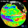
1998-12-05 |
Earth
|
TOPEX/Poseidon
|
Altimeter
|
902x900x3 |
|
-
PIA01498:
-
TOPEX/El Niño Watch - Topex/Poseidon Shows Unusual Pacific, November 29, 1998
Full Resolution:
TIFF
(821.3 kB)
JPEG
(117.7 kB)
|
|
|
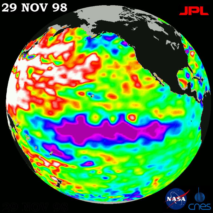
1998-12-05 |
Earth
|
TOPEX/Poseidon
|
Altimeter
|
902x900x3 |
|
-
PIA01497:
-
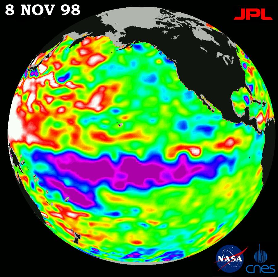
TOPEX/El Niño Watch - La Niña looks "frozen" in Pacific, November 8, 1998
Full Resolution:
TIFF
(827.3 kB)
JPEG
(116.7 kB)
|
|
|
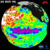
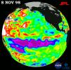
1998-11-04 |
Earth
|
TOPEX/Poseidon
|
Altimeter
|
1912x1908x3 |
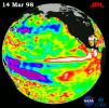
|
-
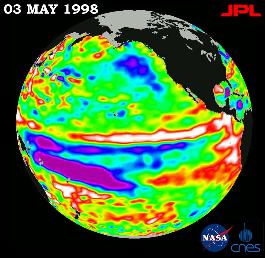
PIA01449:
-
TOPEX/El Niño Watch - Satellite shows El Niño-related Sea Surface Height, Mar, 14, 1998
Full Resolution:
TIFF
(4.161 MB)
JPEG
(361.7 kB)
|
|
|
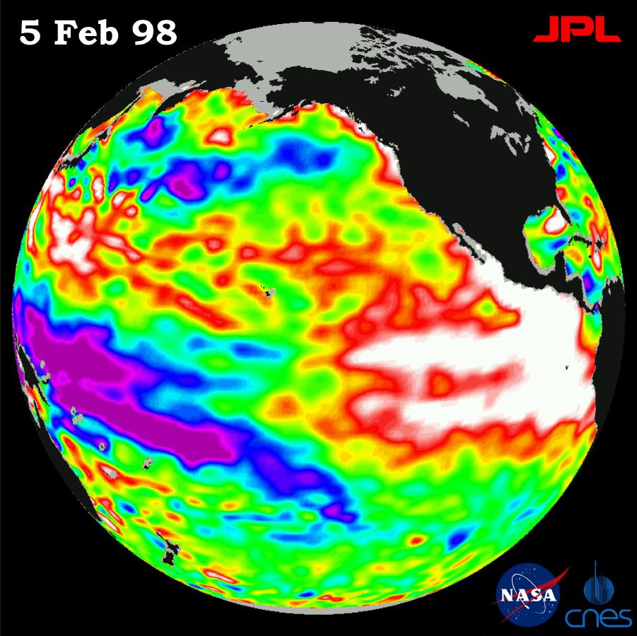
1998-11-04 |
Earth
|
TOPEX/Poseidon
|
Altimeter
|
1908x1908x3 |
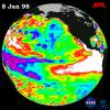
|
-
PIA01164:
-
TOPEX/El Niño Watch - El Niño Warm Water Pool Decreasing, Jan, 08, 1998
Full Resolution:
TIFF
(3.555 MB)
JPEG
(356 kB)
|
|
|
1998-09-26 |
Earth
|
TOPEX/Poseidon
|
Altimeter
|
902x900x3 |
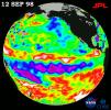
|
-
PIA01474:
-
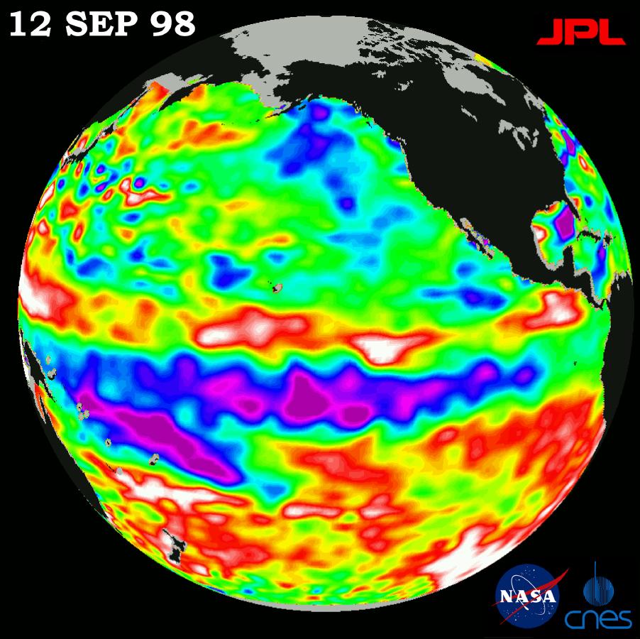
TOPEX/El Niño Watch - Satellite Shows Pacific Running Hot and Cold, September 12, 1998
Full Resolution:
TIFF
(820.8 kB)
JPEG
(120 kB)
|
|
|
1998-09-26 |
Earth
|
TOPEX/Poseidon
|
Altimeter
|
900x900x3 |
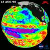
|
-
PIA01473:
-
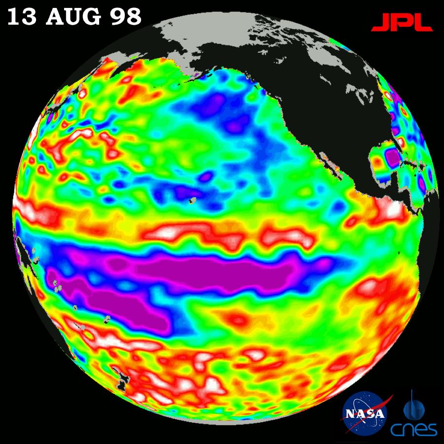
TOPEX/El Niño Watch - Little Change in Pacific, August 13, 1998
Full Resolution:
TIFF
(912.8 kB)
JPEG
(118.6 kB)
|
|
|
1998-07-21 |
Earth
|
TOPEX/Poseidon
|
Altimeter
|
902x900x3 |
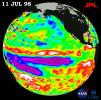
|
-
PIA01461:
-
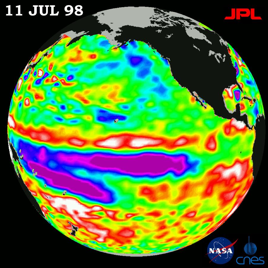
TOPEX/El Niño Watch - Satellite shows Pacific Stabilizing, July 11, 1998
Full Resolution:
TIFF
(872 kB)
JPEG
(117.8 kB)
|
|
|
1998-07-03 |
Earth
|
TOPEX/Poseidon
|
Altimeter
|
901x900x3 |
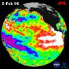
|
-
PIA01448:
-
TOPEX/El Niño Watch - Warm Water Pool is Thinning, Feb, 5, 1998
Full Resolution:
TIFF
(962.8 kB)
JPEG
(115.8 kB)
|
|
|
1998-07-03 |
Earth
|
TOPEX/Poseidon
|
Altimeter
|
900x900x3 |
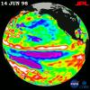
|
-
PIA01453:
-
TOPEX/El Niño Watch - El Niño in Retreat, Pacific in Transition, June 14, 1998
Full Resolution:
TIFF
(963 kB)
JPEG
(118.8 kB)
|
|
|
1998-07-03 |
Earth
|
TOPEX/Poseidon
|
Altimeter
|
923x900x3 |
|
-
PIA01451:
-
TOPEX/El Niño Watch - El Niño is Still Lingering in the Pacific May 3, 1998
Full Resolution:
TIFF
(878.6 kB)
JPEG
(114 kB)
|
|
|
1998-07-03 |
Earth
|
TOPEX/Poseidon
|
Altimeter
|
695x900x3 |
|
-
PIA01450:
-
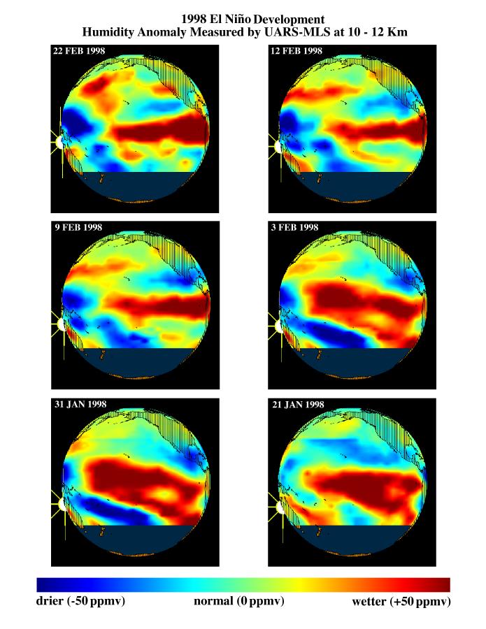
TOPEX/El Niño Watch - Moisture in the Atmosphere, Jan & Feb, 1998
Full Resolution:
TIFF
(540.4 kB)
JPEG
(90.56 kB)
|
|
|
1998-04-02 |
Earth
|
TOPEX/Poseidon
|
Altimeter
|
2550x2545x3 |
|
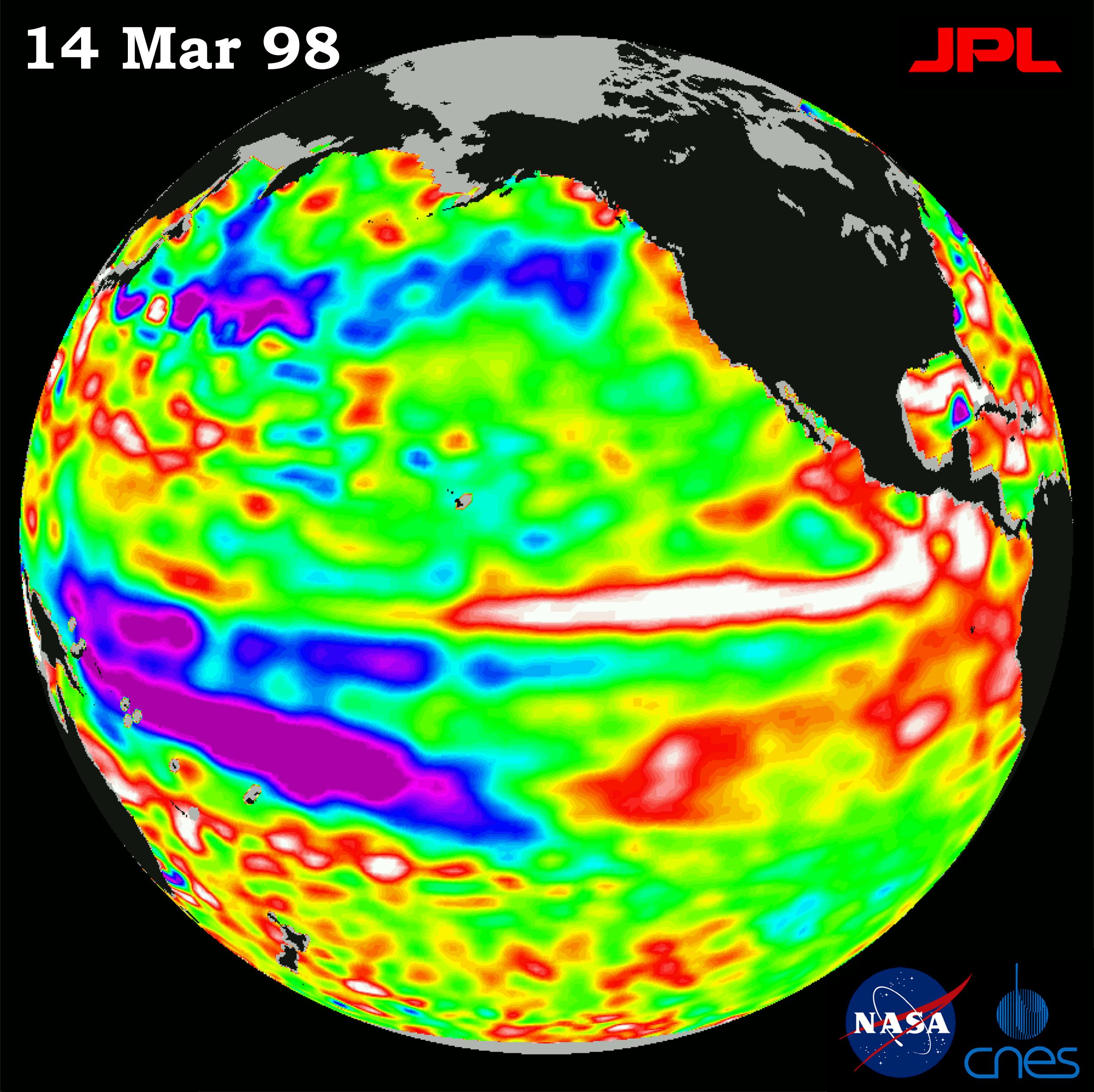
-
PIA00837:
-
TOPEX/El Niño Watch - El Niño Warm Water Pool Returns to Near Normal State, Mar, 14, 1998
Full Resolution:
TIFF
(5.839 MB)
JPEG
(585.3 kB)
|
|
|
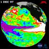
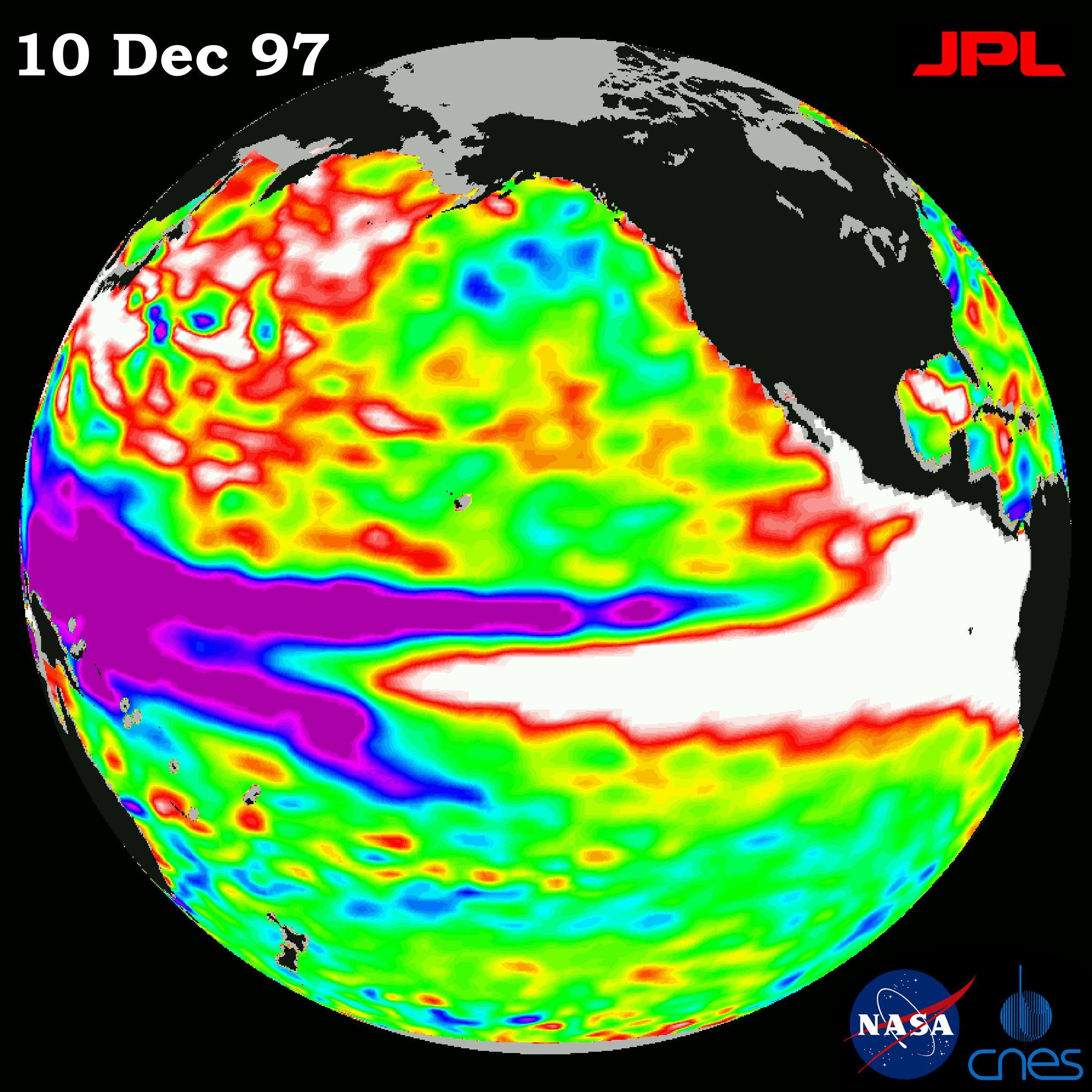
1997-12-19 |
Earth
|
TOPEX/Poseidon
|
Altimeter
|
2550x2550x3 |

|
-
PIA01140:
-
TOPEX/El Niño Watch - El Niño Rhythm, Dec, 10, 1997
Full Resolution:
TIFF
(3.255 MB)
JPEG
(614.2 kB)
|
|
|
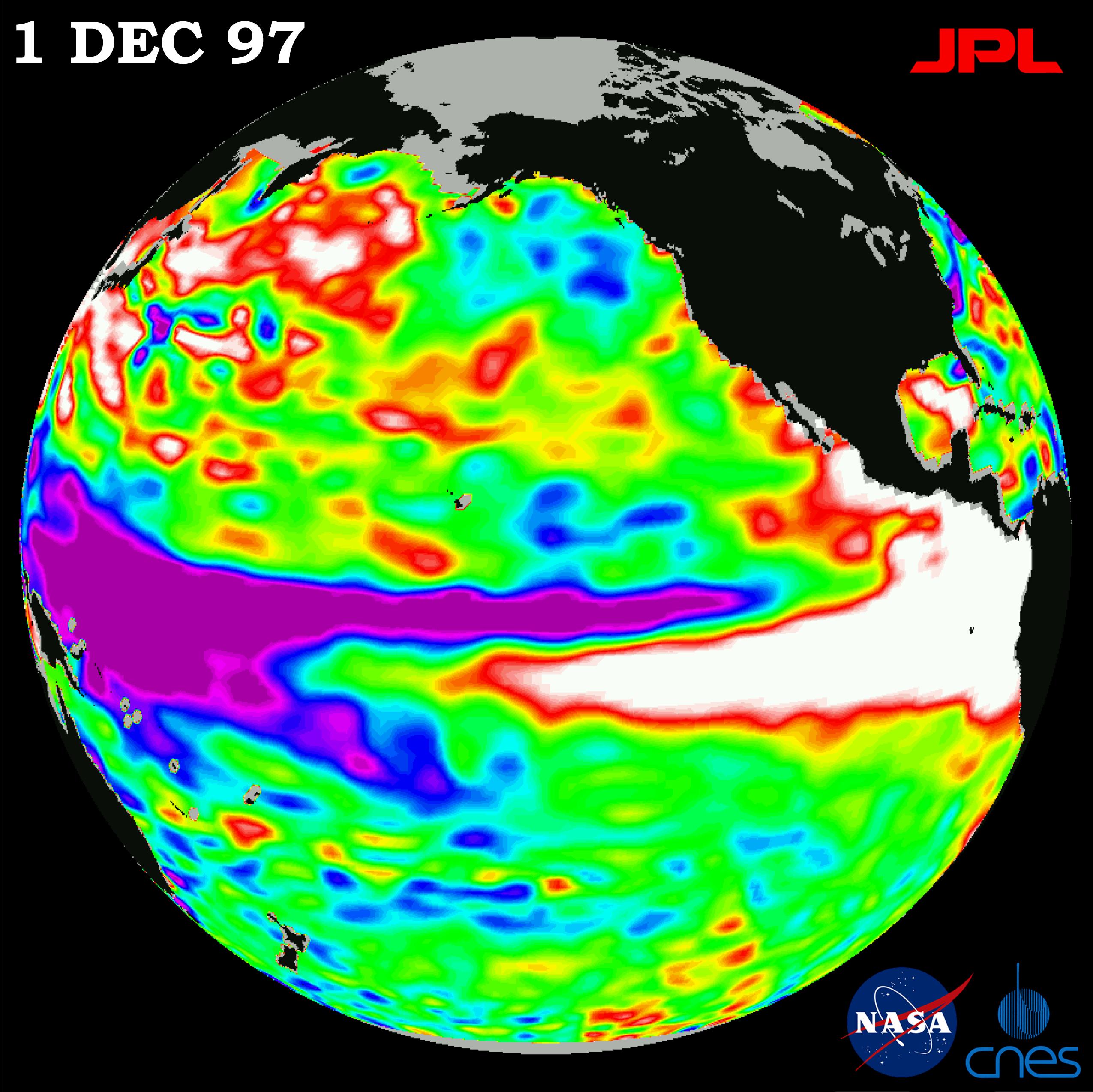
1997-12-08 |
Earth
|
TOPEX/Poseidon
|
Altimeter
|
2550x2548x3 |
|
-
PIA01099:
-
TOPEX/El Niño Watch - "Double Peak" Pattern Complete, Dec, 1, 1997
Full Resolution:
TIFF
(5.241 MB)
JPEG
(569.5 kB)
|
|
|
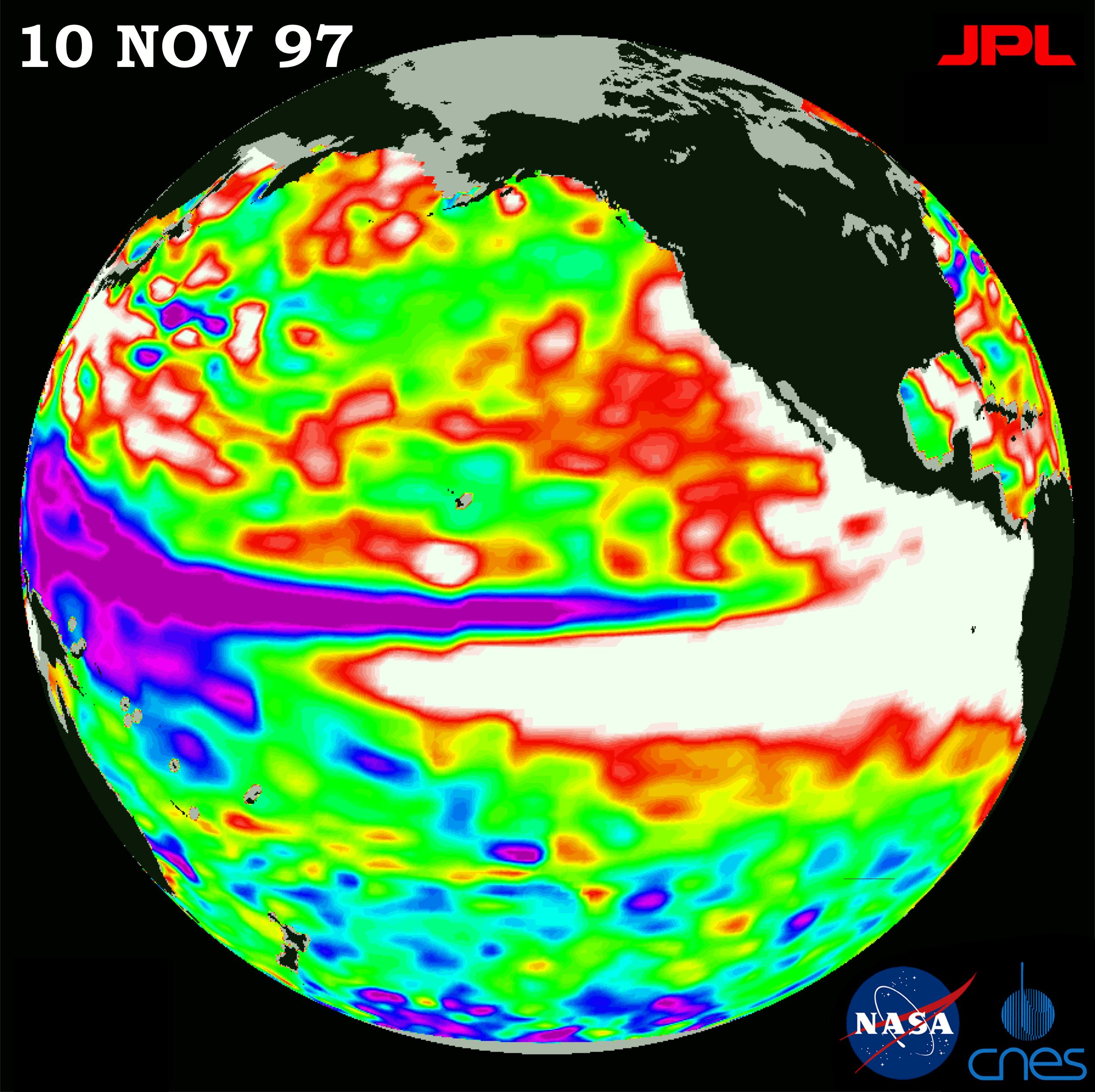
1997-11-20 |
Earth
|
TOPEX/Poseidon
|
Altimeter
|
2550x2544x3 |
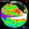
|
-
PIA01085:
-
TOPEX/El Niño Watch - Warm Water Pool is Increasing, Nov. 10, 1997
Full Resolution:
TIFF
(5.509 MB)
JPEG
(577.8 kB)
|
|
|
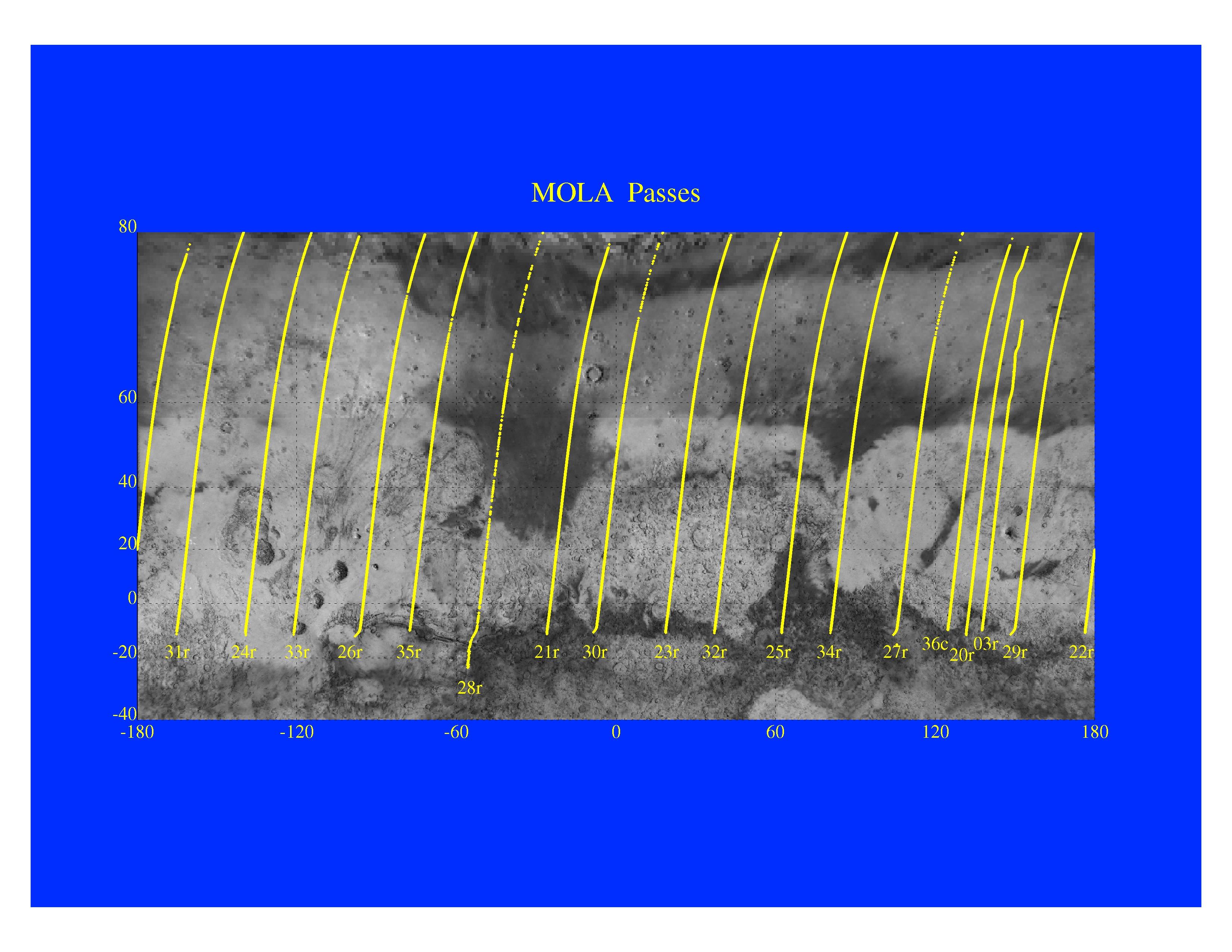
1997-11-10 |
Mars
|
Mars Global Surveyor (MGS)
|
MOLA
|
3300x2550x3 |
|
-
PIA01014:
-
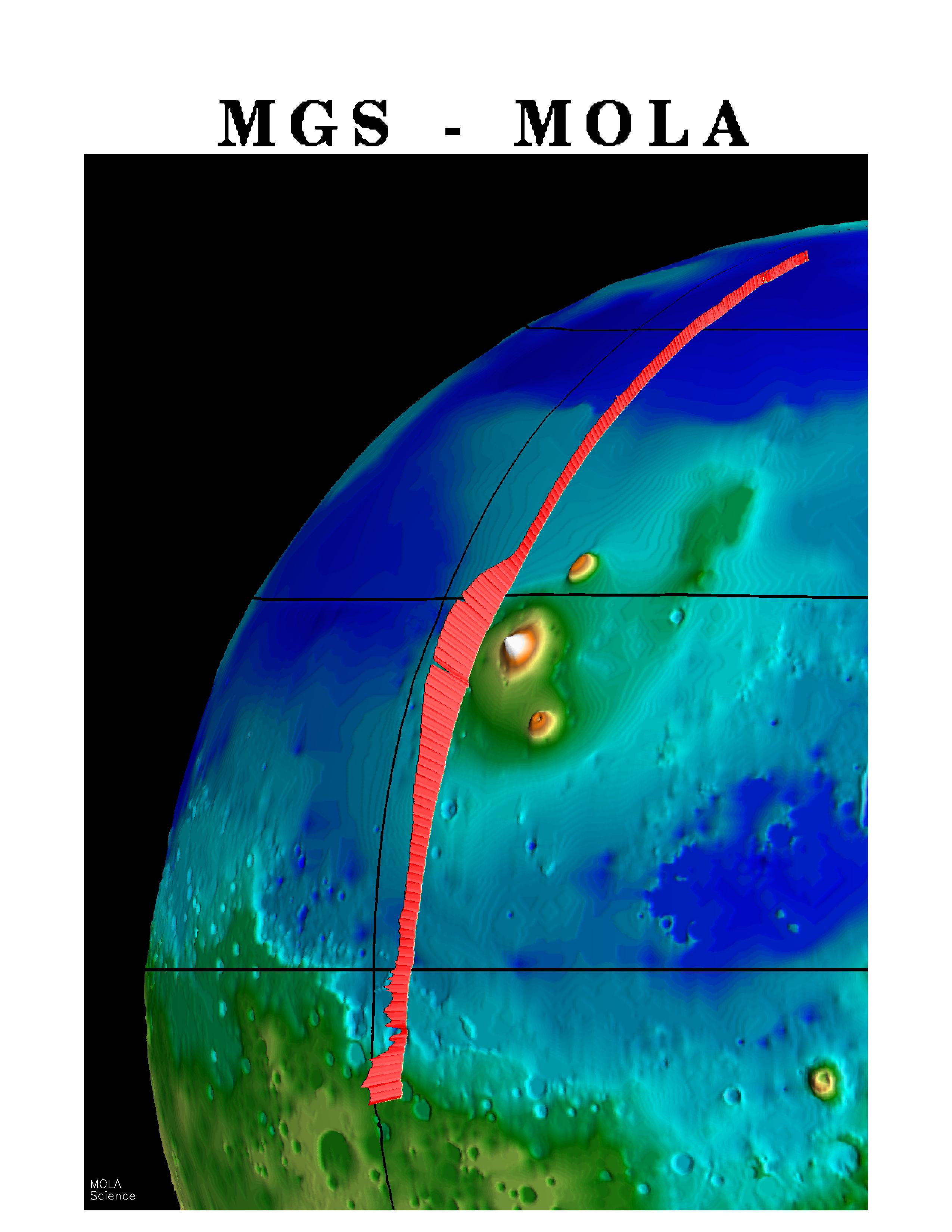
Mars Orbiter Laser Altimeter Passes
Full Resolution:
TIFF
(3.582 MB)
JPEG
(723.3 kB)
|
|
|
1997-11-10 |
Mars
|
Mars Global Surveyor (MGS)
|
MOLA
|
3300x2550x3 |
|
-
PIA01013:
-
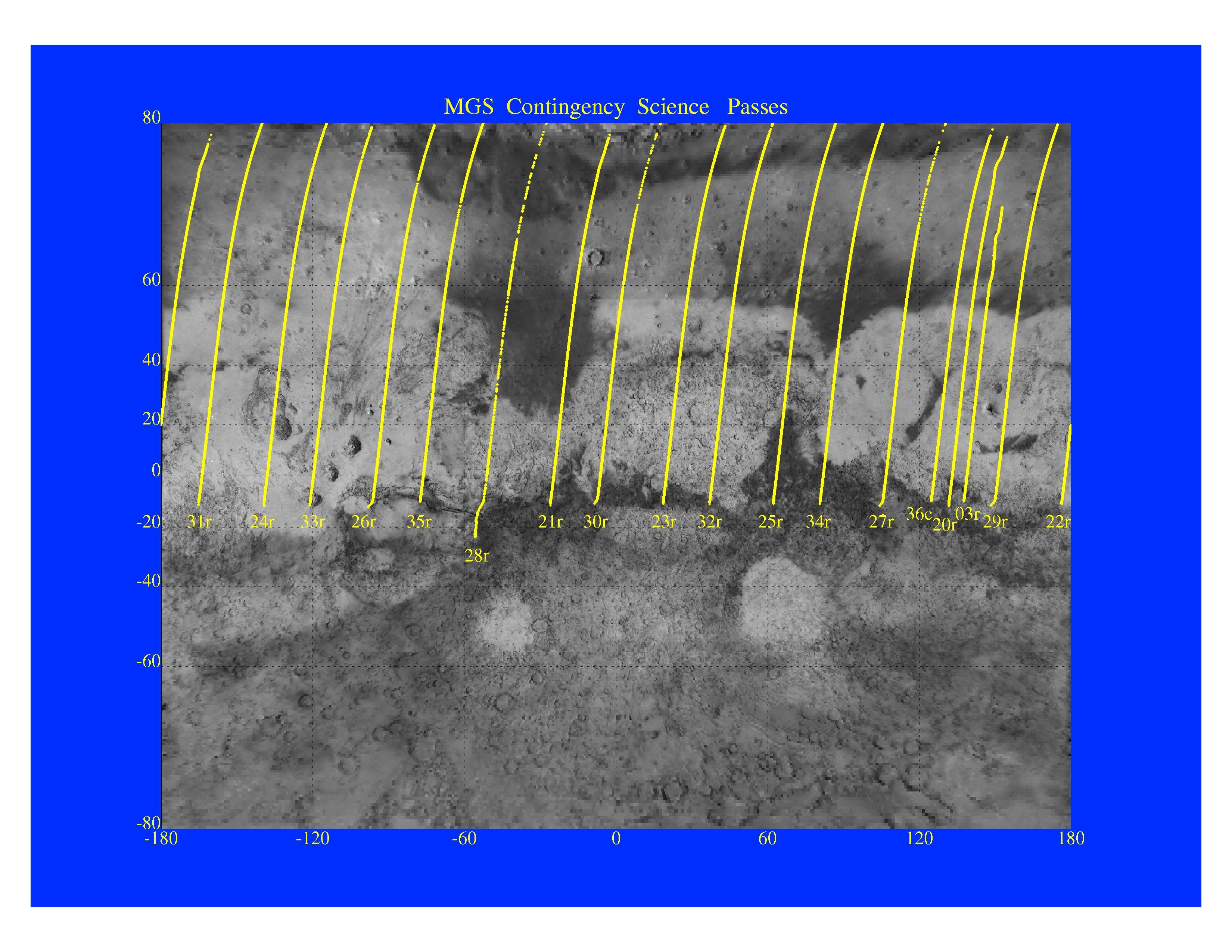
MGS Contingency Science Passes
Full Resolution:
TIFF
(4.409 MB)
JPEG
(879.4 kB)
|
|
|
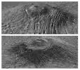
1997-11-10 |
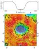
Mars
|
Mars Global Surveyor (MGS)
|
MOLA
|
3300x2550x3 |
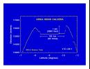
|
-
PIA01012:
-
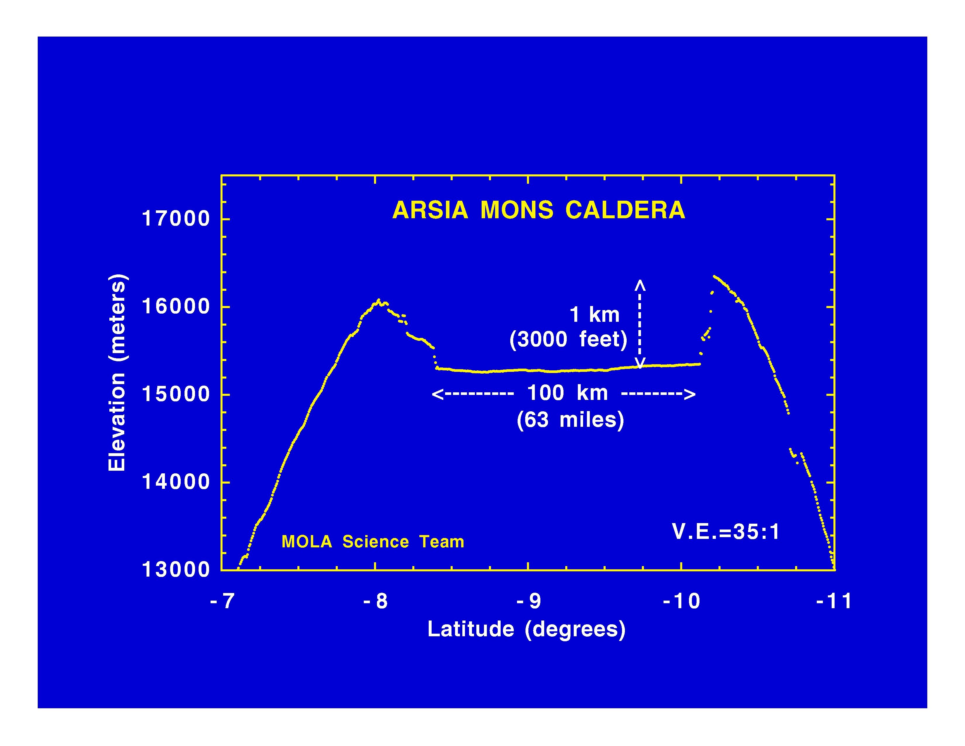
Arsia Mons Caldera
Full Resolution:
TIFF
(534.1 kB)
JPEG
(365.8 kB)
|
|
|
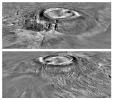
1997-11-10 |
Mars
|
Mars Global Surveyor (MGS)
|
MOLA
|
3300x2550x3 |
|
-
PIA01011:
-
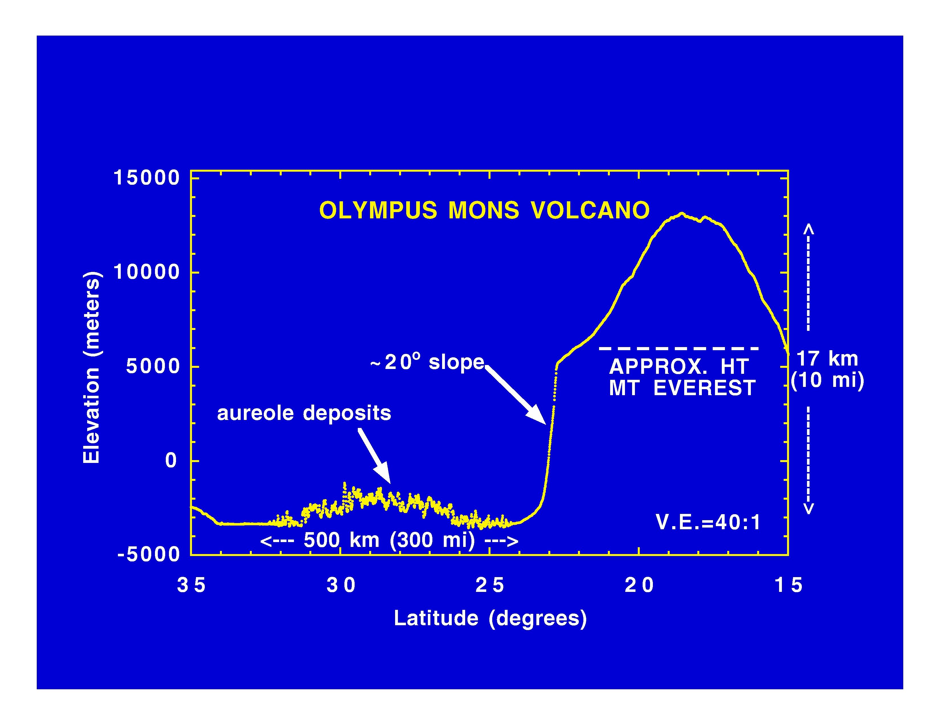
Olympus Mons Volcano
Full Resolution:
TIFF
(625.4 kB)
JPEG
(414.7 kB)
|
|
|
1997-11-10 |
Mars
|
Mars Global Surveyor (MGS)
|
MOLA
|
3300x2550x3 |
|
-
PIA01010:
-
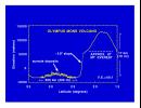
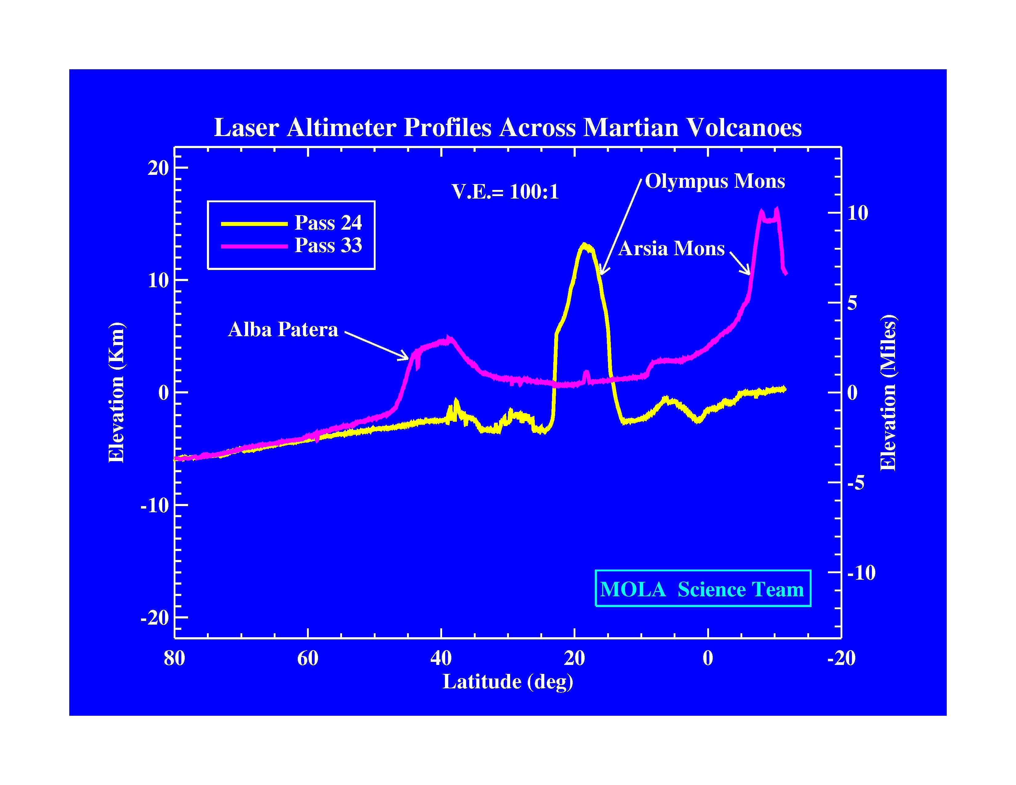
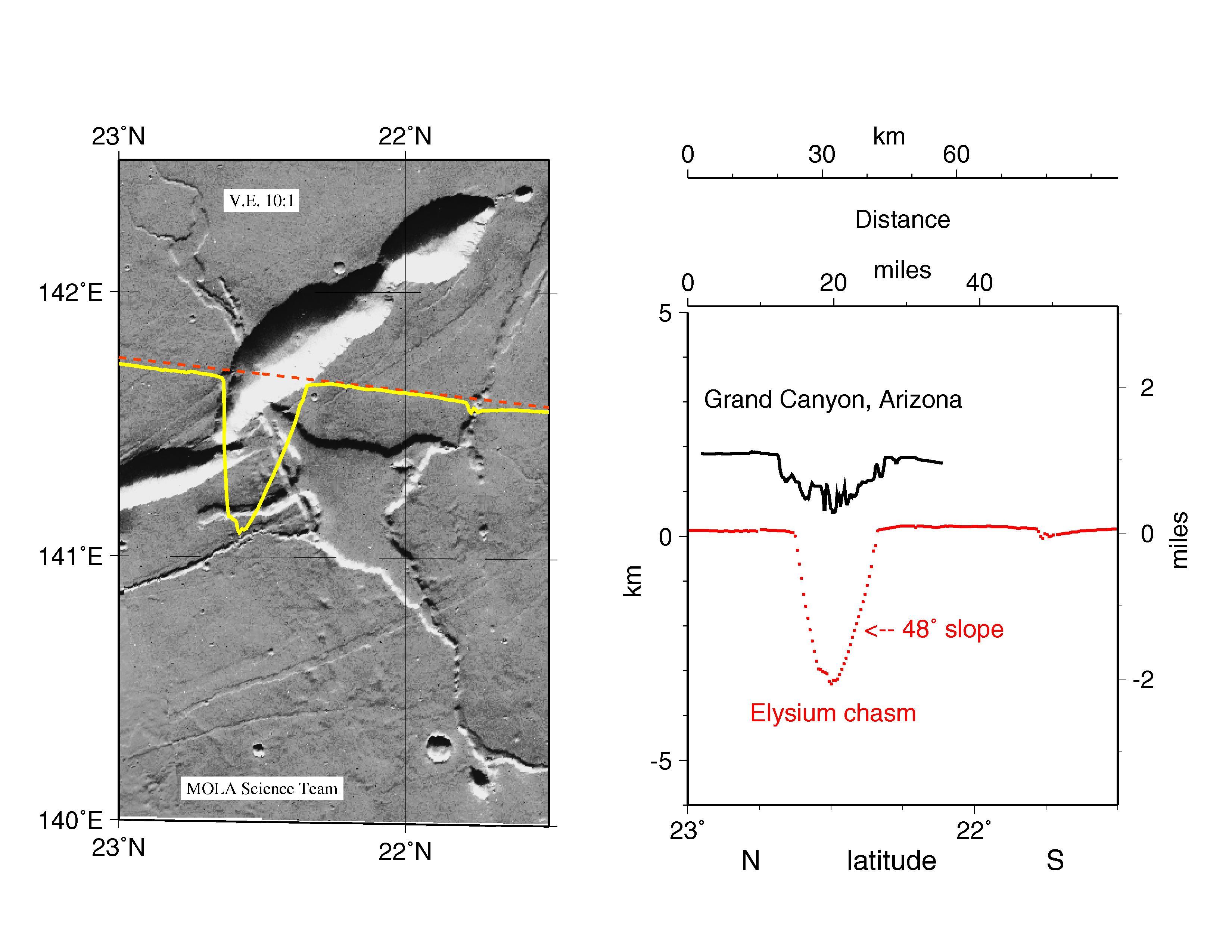
Laser Altimeter Profiles Across Martian Volcanoes
Full Resolution:
TIFF
(677.9 kB)
JPEG
(424.4 kB)
|
|
|
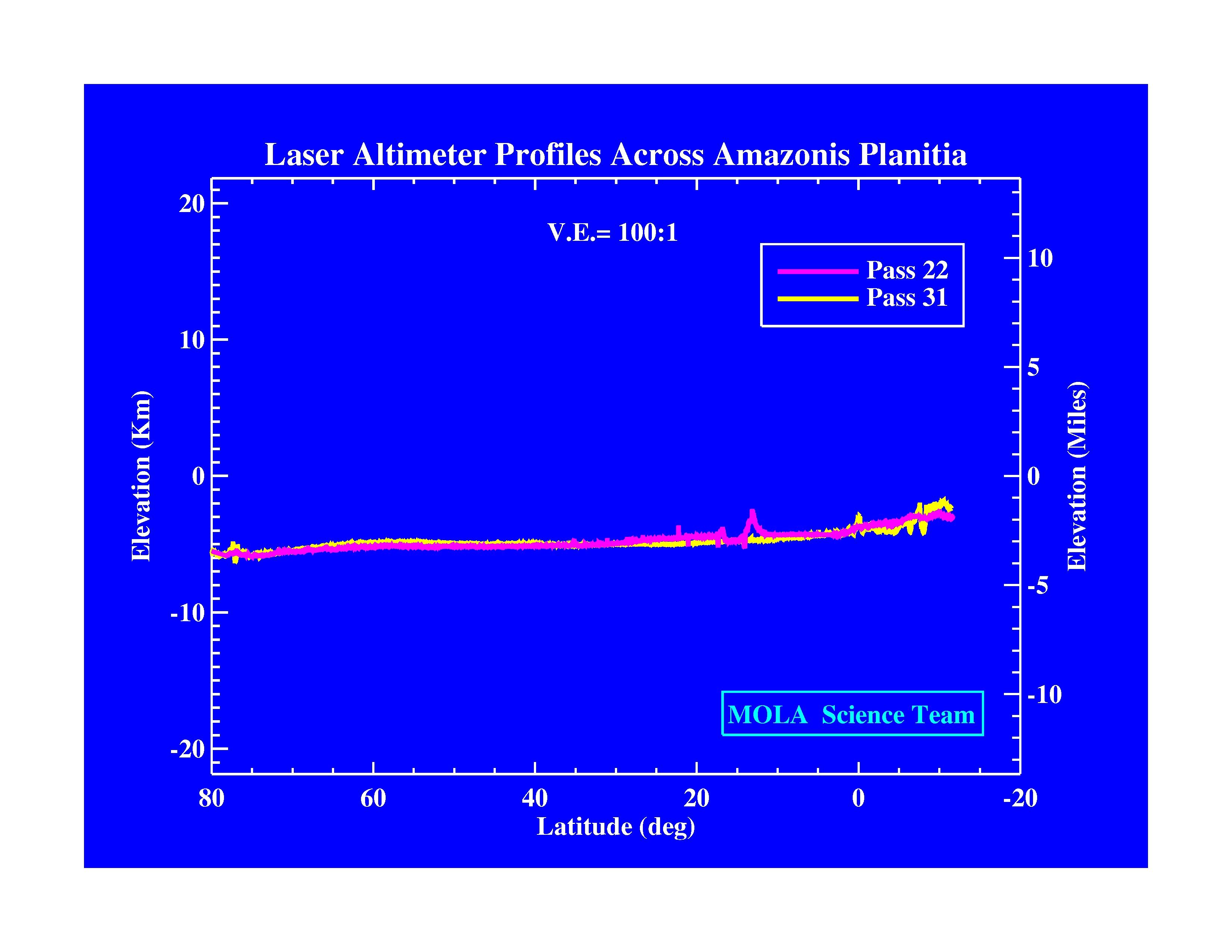
1997-11-10 |
Mars
|
Mars Global Surveyor (MGS)
|
MOLA
|
3300x2550x3 |
|
-
PIA01009:
-
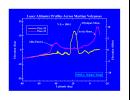
Laser Altimeter Profiles Across Amazonis Planitia
Full Resolution:
TIFF
(530.8 kB)
JPEG
(371.9 kB)
|
|
|
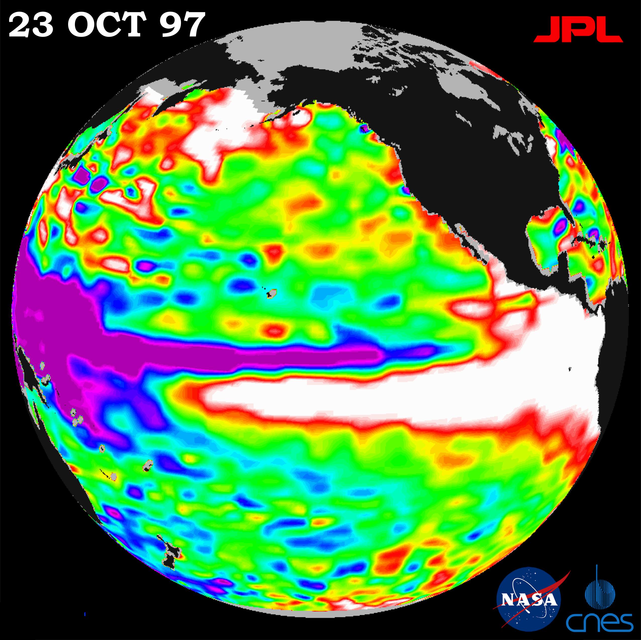
1997-10-30 |
Earth
|
TOPEX/Poseidon
|
Altimeter
|
2550x2545x3 |
|
-
PIA01053:
-
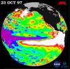
TOPEX/El Niño Watch - October 23, 1997
Full Resolution:
TIFF
(4.569 MB)
JPEG
(562.8 kB)
|
|
|
1997-10-14 |
Earth
|
TOPEX/Poseidon
|
Altimeter
|
2154x1036x3 |
|
-
PIA00742:
-
TOPEX/El Niño Watch - Indonesia Area, December, 1996 and August, 1997
Full Resolution:
TIFF
(3.323 MB)
JPEG
(282.5 kB)
|
|
|
1997-10-14 |
Earth
|
TOPEX/Poseidon
|
Altimeter
|
2000x2000x3 |
|
-
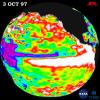
PIA00741:
-
TOPEX/El Niño Watch - October 3, 1997
Full Resolution:
TIFF
(2.293 MB)
JPEG
(424.1 kB)
|
|
|
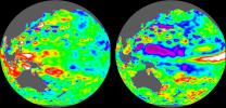
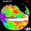
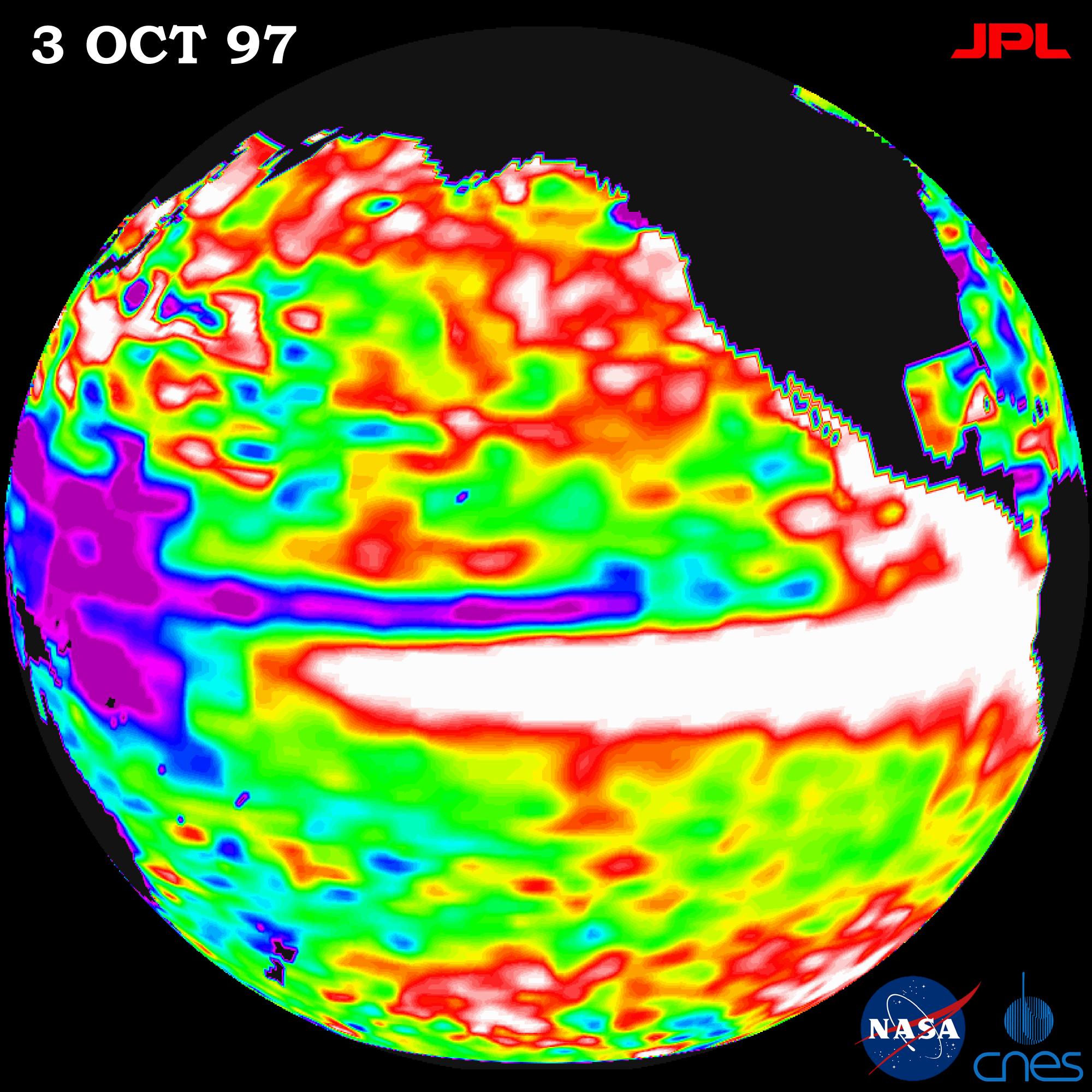
1997-10-14 |
Earth
|
TOPEX/Poseidon
|
Altimeter
|
900x900x3 |
|
-
PIA00736:
-
TOPEX/El Niño Watch- September 20, 1997
Full Resolution:
TIFF
(187.3 kB)
JPEG
(120.7 kB)
|
|
|
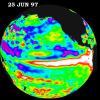
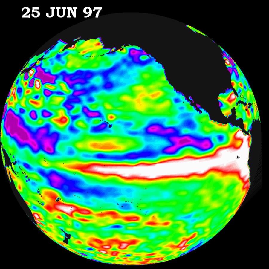
1997-10-14 |
Earth
|
TOPEX/Poseidon
|
Altimeter
|
900x900x3 |
|
-
PIA00735:
-
TOPEX/El Niño Watch - June 25, 1997
Full Resolution:
TIFF
(889.7 kB)
JPEG
(106.5 kB)
|
|
|
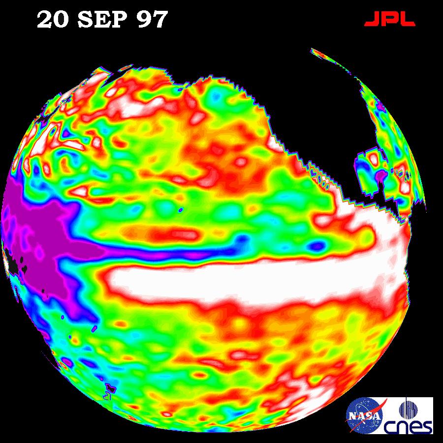
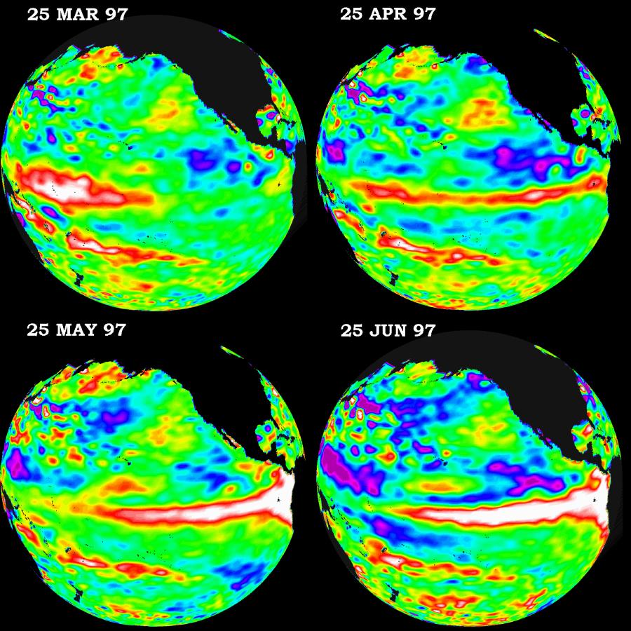
1997-10-14 |
Earth
|
TOPEX/Poseidon
|
Altimeter
|
900x900x3 |
|
-
PIA00734:
-
TOPEX/El Niño Watch - March thru June, 1997
Full Resolution:
TIFF
(1.041 MB)
JPEG
(149.8 kB)
|
|
|
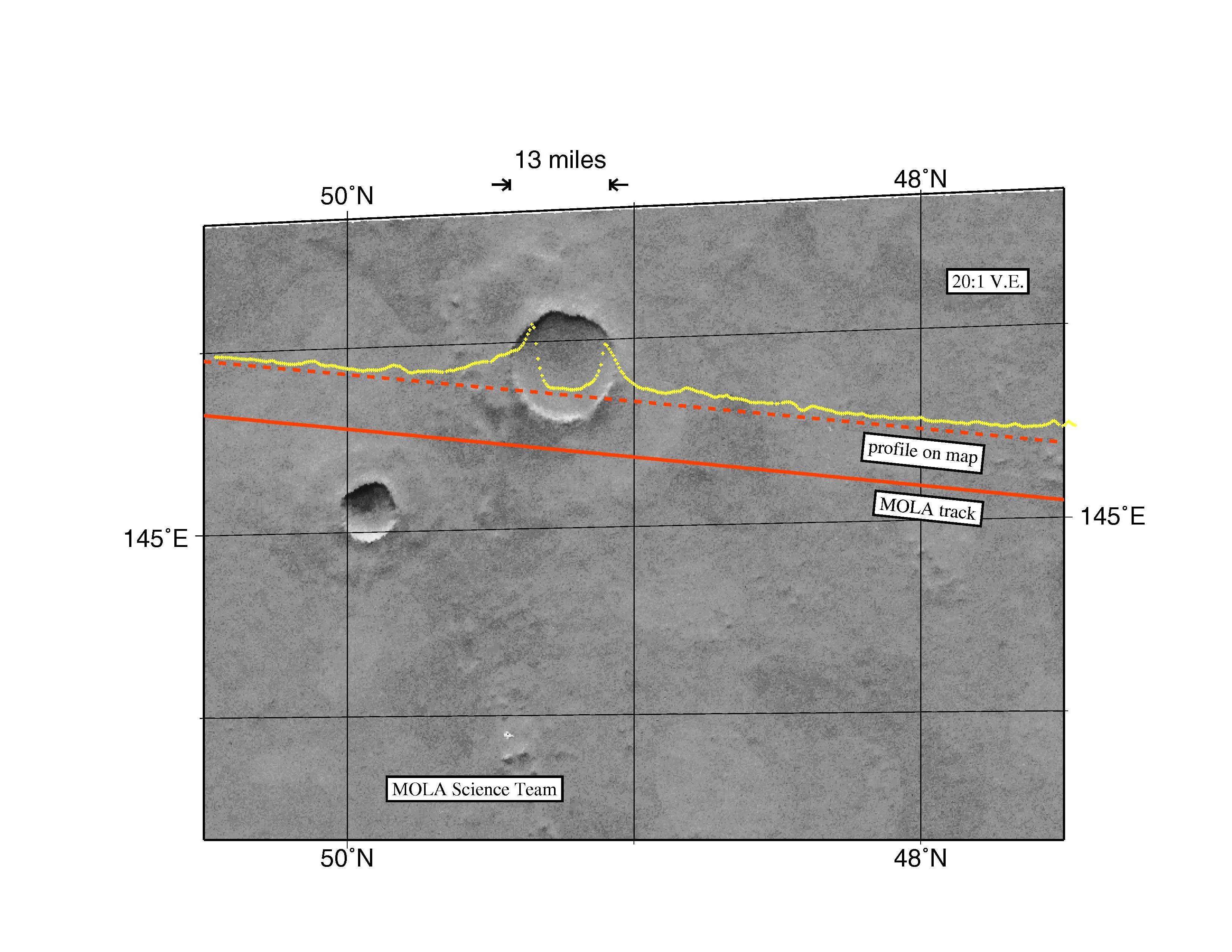
1997-10-13 |
Mars
|
Mars Global Surveyor (MGS)
|
MOLA
|
3300x2550x3 |
|
-
PIA00959:
-
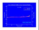
MGS Mars Orbiter Laser Altimeter Topographic Profile of Impact Crater
Full Resolution:
TIFF
(5.47 MB)
JPEG
(741 kB)
|
|
|
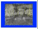
1997-10-13 |
Mars
|
Mars Global Surveyor (MGS)
|
MOLA
|
3300x2550x3 |
|
-
PIA00960:
-
MGS Mars Orbiter Laser Altimeter (MOLA) - Mars/Earth Relief Comparison
Full Resolution:
TIFF
(3.639 MB)
JPEG
(615.3 kB)
|
|
|
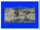
1997-10-13 |
Mars
|
Mars Global Surveyor (MGS)
|
MOLA
|
3300x1634x3 |

|
-
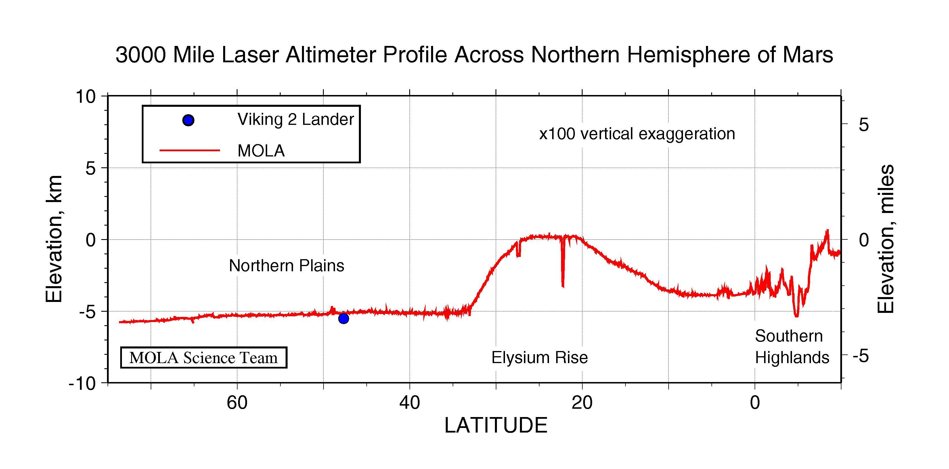
PIA00958:
-
3000 Mile Laser Altimeter Profile Across Northern Hemisphere of Mars
Full Resolution:
TIFF
(730.3 kB)
JPEG
(341 kB)
|
|
|
1997-10-13 |
Mars
|
Mars Global Surveyor (MGS)
|
MOLA
|
2550x3300x3 |
|
-
PIA00957:
-
MGS Mars Orbiter Laser (MOLA) Surface Topography of Northern Hemisphere
Full Resolution:
TIFF
(8.502 MB)
JPEG
(439.4 kB)
|
 Planetary Data System


