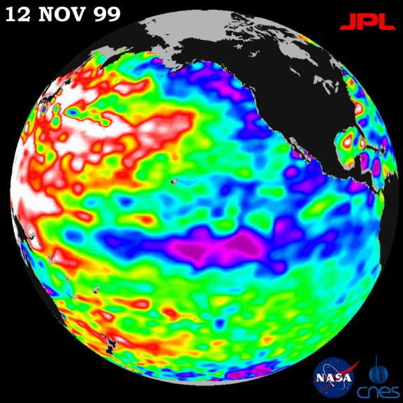
Unusually warm ocean temperatures off Asia and cool waters in the eastern and equatorial Pacific are signaling La Niña's mild return, according to the latest sea-surface heights observed by the joint NASA-French space agency's TOPEX/Poseidon satellite.
Lower than normal sea-surface heights in the eastern North Pacific and abnormally high sea-surface heights in the western and mid-latitude Pacific are expected to drive storms coming out of the Pacific this winter, the mission data indicate. Those conditions will most likely steer storms north into the Pacific Northwest and keep the southwestern United States dryer than normal.
The latest measurements, processed after a 10-day data cycle November 4-13 at NASA's Jet Propulsion Laboratory, Pasadena, CA, are available at http://www.jpl.nasa.gov/elnino . Sea-surface height is shown relative to normal (green) and reveals cooler water (blue and purple) measuring between 8 and 24 centimeters (3 to 9 inches) lower than average in the eastern North Pacific, from the Gulf of Alaska to central Alaska, and along the equator.
Unusual conditions persist in the western and mid-latitude Pacific Ocean as well, with higher than average sea-surface heights(red and white) of between 8 and 24 centimeters (3 to 9 inches). These areas of increased sea-surface height and unusually warm water were present last year, but the increase in height has surpassed last year's measurements.
The TOPEX/Poseidon satellite's measurements over the last seven and a half years have provided scientists with a comprehensive record of the 1997-1999 El Niño/La Niña climate pattern by measuring changing sea-surface heights to within 4centimeters (1.5 inches) precision.
The U.S./French mission is managed by the Jet Propulsion Laboratory for NASA's Earth Sciences Enterprise, Washington, DC. JPL is a division of the California Institute of Technology, Pasadena, CA.
For more information, please visit the TOPEX/Poseidon project web page at http://topex-www.jpl.nasa.gov/
 Planetary Data System


