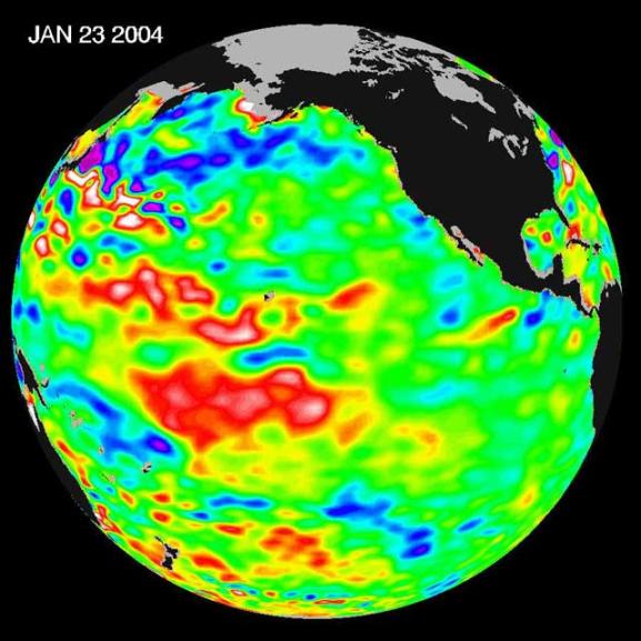
The latest remote sensing data from NASA's Jason satellite show that the equatorial Pacific sea surface levels are higher, indicating warmer sea surface temperatures in the central and west Pacific Ocean. This pattern has the appearance of La Nińa rather than El Nińo. This contrasts with the Bering Sea, Gulf of Alaska and U.S. West Coast where lower-than-normal sea surface levels and cool ocean temperatures continue (indicated by blue and purple areas).
The image above is a global map of sea surface height, accurate to within 30 millimeters. The image represents data collected and composited over a 10-day period, ending on Jan 23, 2004. The height of the water relates to the temperature of the water. As the ocean warms, its level rises; and as it cools, its level falls. Yellow and red areas indicate where the waters are relatively warmer and have expanded above sea level, green indicates near normal sea level, and blue and purple areas show where the waters are relatively colder and the surface is lower than sea level. The blue areas are between 5 and 13 centimeters (2 and 5 inches) below normal, whereas the purple areas range from 14 to 18 centimeters (6 to 7 inches) below normal.
The Jason satellite carries a dual-frequency radar altimeter. This instrument beams microwave pulses-at 13.6 and 5.3 Gigahertz, respectively-downward toward the Earth. To determine the ocean's height, the instrument precisely measures the time it takes for the microwave pulses to bounce off the surface and return to the spacecraft. This measure, multiplied by the speed of light, gives the range from the satellite to the ocean surface. (For more details, visit the Jason Website.)
The joint U.S.-French Topex/Poseidon mission is managed by the JPL for NASA's Earth Science Enterprise, NASA Headquarters, Washington, D.C. JPL is a division of the California Institute of Technology in Pasadena. Research on Earth's oceans using Jason and other space-based capabilities is conducted by NASA's Earth Science Enterprise to better understand and protect our home planet. For more information on Topex/Poseidon, see http://topex-www.jpl.nasa.gov.