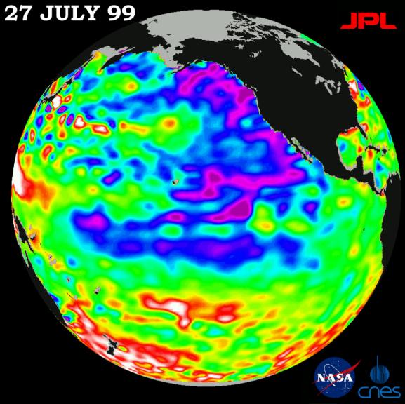
The North Pacific Ocean continues to run hot and cold, with abnormally low sea levels and cool waters in the northeastern Pacific contrasting with unusually high sea levels and warm waters in the northwestern Pacific.
New imagery from the joint NASA and French space agency's TOPEX/Poseidon orbiting satellite, which celebrates its 7th launch anniversary next week, shows strongly contrasting ocean levels and temperatures on opposite sides of the north Pacific. This pattern was locked in more than four months ago, when a very strong, high-pressure system began to dominate northern Pacific atmospheric and ocean patterns. Present conditions will be slow to change, according to oceanographer Dr. William Patzert of NASA's Jet Propulsion Laboratory, Pasadena, CA, and will influence climate over North America into the fall.
"The north Pacific, which drives U.S. climate, is still extremely out of balance, with warm waters in the west and cool waters in the east," Patzert said. "When we see these large contrasts in the ocean, the weather delivery system -- the jet stream coming out of the north Pacific -- will do very unusual things. Like the stock market, we have a very volatile situation brought on by the persistence of these ocean imbalances."
The latest sea-surface height measurements, available at http://www.jpl.nasa.gov/elnino/, reveal unusually cool water (shown in blue and purple) and lower sea levels (5 to 18 centimeters or 2 to 7 inches below normal) extending from the Gulf of Alaska along the coast of North America. The lower sea levels sweep south-southwest from Baja California, to merge with the remnants of La Niña. Cool, lower equatorial sea levels from La Niña remain weak, but are still evident along the equator. On the other side of the north Pacific, sea levels remain high (10 to 32 centimeters or 4 to 13 inches above normal) and temperatures are warm (shown in red and white). Normal sea levels appear in green. The data were collected on a 10-day data-gathering cycle taken July 18-27.
Since its launch on August 10, 1992, TOPEX/Poseidon has performed nearly flawlessly, collecting information about the height of the sea's surface at an unprecedented accuracy of 4 centimeters (15 inches). Using this information, scientists from NASA and the Centre National d'Etudes Spatiales have been able to map and forecast the impact of the 1997-1998 El Niño and the La Niña that followed and continues to hang on.
"These highly accurate global measurements of the sea-surface height of our oceans have vastly improved our understanding of the oceans and how they exchange energy with Earth's atmosphere to alter the weather and climate," said Charles Yamarone, manager of JPL's Earth Science Flight Projects office. "The satellite has, in fact, produced the longest record of precision global ocean topography to date and given us a wealth of new information about ocean circulation."
"Additionally, in the last seven years, we have seen many societal benefits from TOPEX/Poseidon observations," Yamarone said. "Our data are being used to support a wide range of activities, including ship routing, cable laying, fisheries management and hurricane forecasting."
Although La Niña appears to be waning, Patzert added, the ocean abnormality is probably not gone for good. "La Niña might be temporarily down, but she's definitely not out," he said. "What we are seeing from space in these wildly fluctuating sea levels and temperature variations is a continuing hangover from La Niña."
The U.S./French TOPEX/Poseidon mission is managed by the Jet Propulsion Laboratory for NASA's Office of Earth Sciences, Washington, DC. JPL is a division of the California Institute of Technology, Pasadena, CA.
For more information, please visit the TOPEX/Poseidon project web page at http://topex-www.jpl.nasa.gov/
 Planetary Data System


