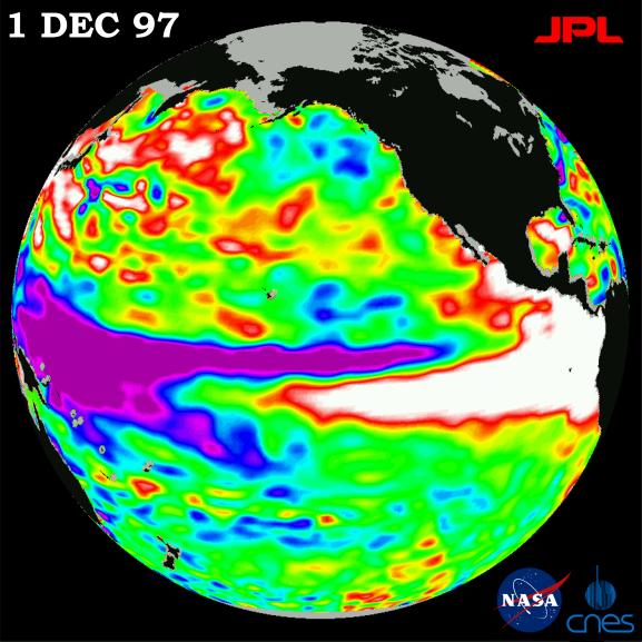
This image of the Pacific Ocean was produced using sea surface height measurements taken by the U.S./French TOPEX/Poseidon satellite. The image shows sea surface height relative to normal ocean conditions on Dec. 1, 1997. The volume of the warm water related to El Nińo has receded to about the level it was in early September. Oceanographers note that this El Nińo has just completed a classic "double peak" pattern in the eastern Pacific with the first peak in sea level occurring in July and the second peak in October. This pattern is very similar to what was observed during the 1982-83 El Nińo, although at that time the double peaks occurred in January and April 1983. After the appearance of the double peaks in 1982-83, the sea level then began falling back to normal levels within a few months. In this image, the white and red areas indicate unusual patterns of heat storage; in the white areas, the sea surface is between 14 and 32 centimeters (6 to 13 inches) above normal; in the red areas, it's about 10 centimeters (4 inches) above normal. The green areas indicate normal conditions, while purple (the western Pacific) means at least 18 centimeters (7 inches) below normal sea level.
The El Nińo phenomenon is thought to be triggered when the steady westward blowing trade winds weaken and even reverse direction. This change in the winds allows a large mass of warm water (the red and white area) that is normally located near Australia to move eastward along the equator until it reaches the coast of South America. The displacement of so much warm water affects evaporation, where rain clouds form and, consequently, alters the typical atmospheric jet stream patterns around the world. Using these global data, limited regional measurements from buoys and ships, and a forecasting model of the ocean-atmosphere system, the National Centers for Environmental Prediction (NCEP) of the National Oceanic and Atmospheric Administration, (NOAA), has issued an advisory indicating the presence of a strong El Nińo condition throughout the winter.
For more information, please visit the TOPEX/Poseidon project web page at http://topex-www.jpl.nasa.gov