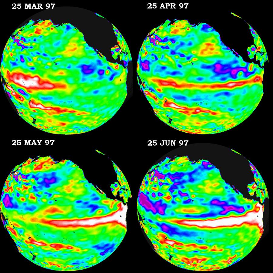
These four views of the Pacific Ocean were produced using sea surface height measurements taken by the U.S./French TOPEX/POSEIDON satellite. The images show sea surface height relative to normal ocean conditions from March 1997 through June 1997. This evolutionary view is providing oceanographers with more convincing information that the weather-disrupting phenomenon known as El Niño is back and getting stronger. The white and red areas indicate unusual patterns of heat storage; in the white areas, the sea surface is between 14 and 32 centimeters (6 to 13 inches) above normal; in the red areas, it s about 10 centimeters (4 inches) above normal. The surface area covered by the warm water mass is about one and one-half times the size of the continental United States. The added amount of oceanic warm water near the Americas, with a temperature between 21-30 degrees Celsius (70-85 degrees Fahrenheit), is about 30 times the volume of water in all the U.S. Great Lakes combined. The green areas indicate normal conditions, while purple (the western Pacific) means at least 18 centimeters (7 inches) below normal sea level.
The El Niño phenomenon is thought to be triggered when the steady westward blowing trade winds weaken and even reverse direction. This change in the winds allows a large mass of warm water (the red and white area) that is normally located near Australia to move eastward along the equator until it reaches the coast of South America. The displacement of so much warm water affects evaporation, where rain clouds form and, consequently, alters the typical atmospheric jet stream patterns around the world. Using these global data, limited regional measurements from buoys and ships, and a forecasting model of the ocean-atmosphere system, the National Centers for Environmental Prediction (NCEP) of the National Oceanic and Atmospheric Administration, (NOAA), has issued an advisory indicating the presence of the early indications of El Niño conditions.
 Planetary Data System


