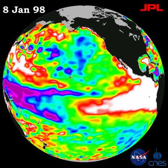
This image of the Pacific Ocean was produced using sea surface height measurements taken by the U.S.-French TOPEX/Poseidon satellite. The image shows sea surface height relative to normal ocean conditions on Jan. 8, 1998, and sea surface height is an indicator of the heat content of the ocean. The volume of the warm water pool related to the El Nińo has decreased by about 40 percent since its maximum in early November, but the area of the warm water pool is still about one and a half times the size of the continental United States. The volume measurements are computed as the sum of all the sea surface height changes as compared to normal ocean conditions. In addition, the maximum water temperature in the eastern tropical Pacific, as measured by the National Oceanic and Atmospheric Administration (NOAA), is still higher than normal. Until these high temperatures diminish, the El Nińo warm water pool still has great potential to disrupt global weather because the high water temperatures directly influence the atmosphere. Oceanographers believe the recent decrease in the size of the warm water pool is a normal part of El Nińo's natural rhythm. TOPEX/Poseidon has been tracking these fluctuations of the El Nińo warm pool since it began in early 1997. These sea surface height measurements have provided scientists with their first detailed view of how El Nińo's warm pool behaves because the TOPEX/Poseidon satellite measures the changing sea surface height with unprecedented precision. In this image, the white and red areas indicate unusual patterns of heat storage; in the white areas, the sea surface is between 14 and 32 centimeters (6 to 13 inches) above normal; in the red areas, it's about 10 centimeters (4 inches) above normal. The green areas indicate normal conditions, while purple (the western Pacific) means at least 18 centimeters (7 inches) below normal sea level.
The El Nińo phenomenon is thought to be triggered when the steady westward blowing trade winds weaken and even reverse direction. This change in the winds allows a large mass of warm water (the red and white area) that is normally located near Australia to move eastward along the equator until it reaches the coast of South America. The displacement of so much warm water affects evaporation, where rain clouds form and, consequently, alters the typical atmospheric jet stream patterns around the world. Using these global data, limited regional measurements from buoys and ships, and a forecasting model of the ocean-atmosphere system, the National Centers for Environmental Prediction (NCEP) of the National Oceanic and Atmospheric Administration, (NOAA), has issued an advisory indicating the presence of a strong El Nińo condition throughout the winter.
For more information, please visit the TOPEX/Poseidon project web page at http://topex-www.jpl.nasa.gov