My
List |
Addition Date
|
Target
|
Mission
|
Instrument
|
Size
|

|
2019-11-12 |
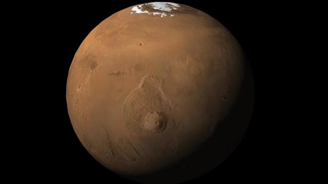
Mars
|
Mars Reconnaissance Orbiter (MRO)
Mars Express (MEX)
Mars Global Surveyor (MGS)
|
CRISM
CTX
MOLA
High Resolution Stereo Camera
|
3663x2535x3 |
|
-
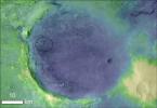
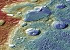
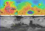
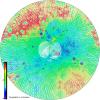
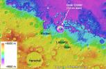
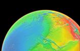
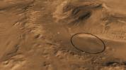
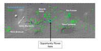
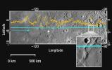
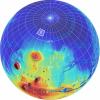
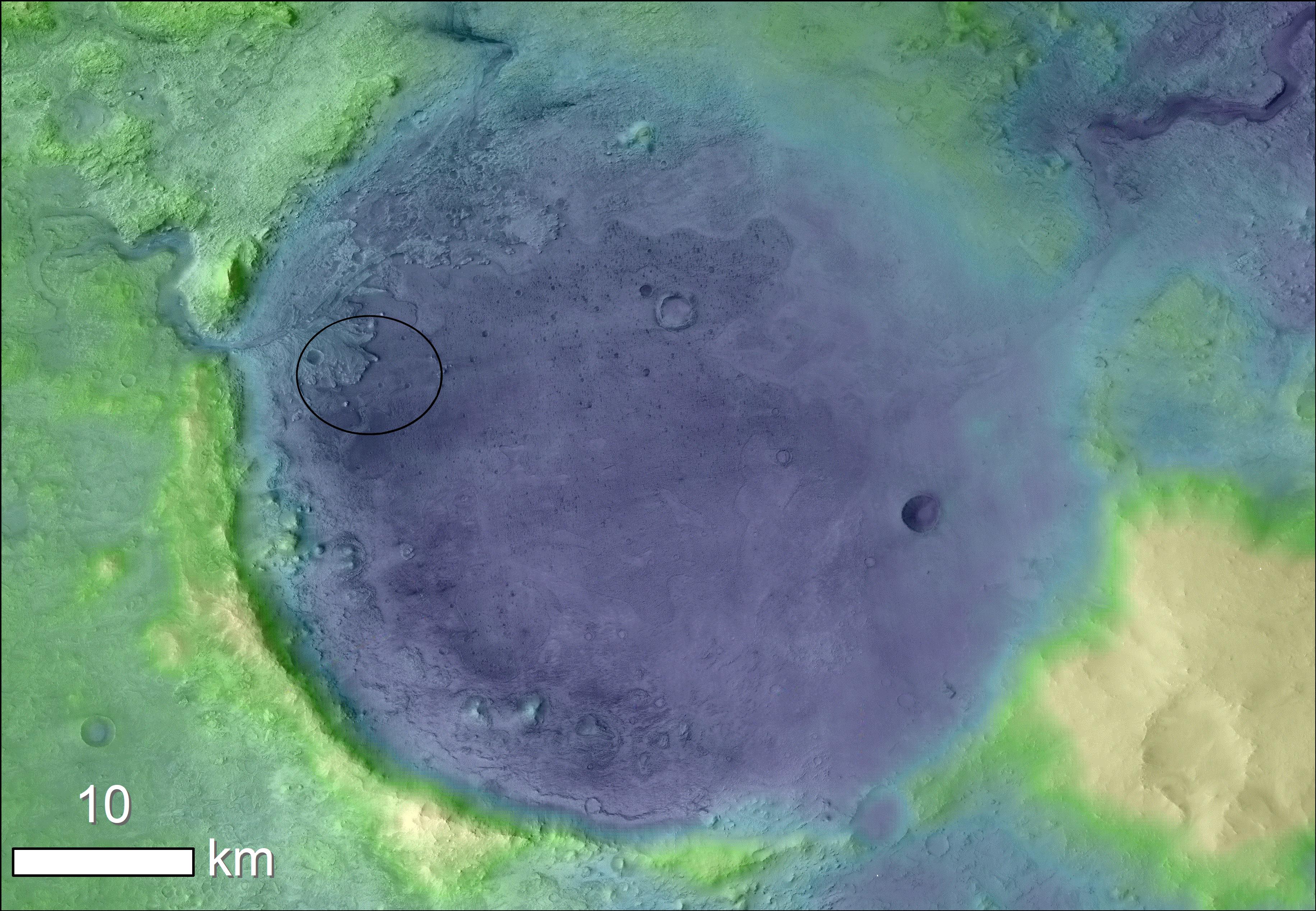
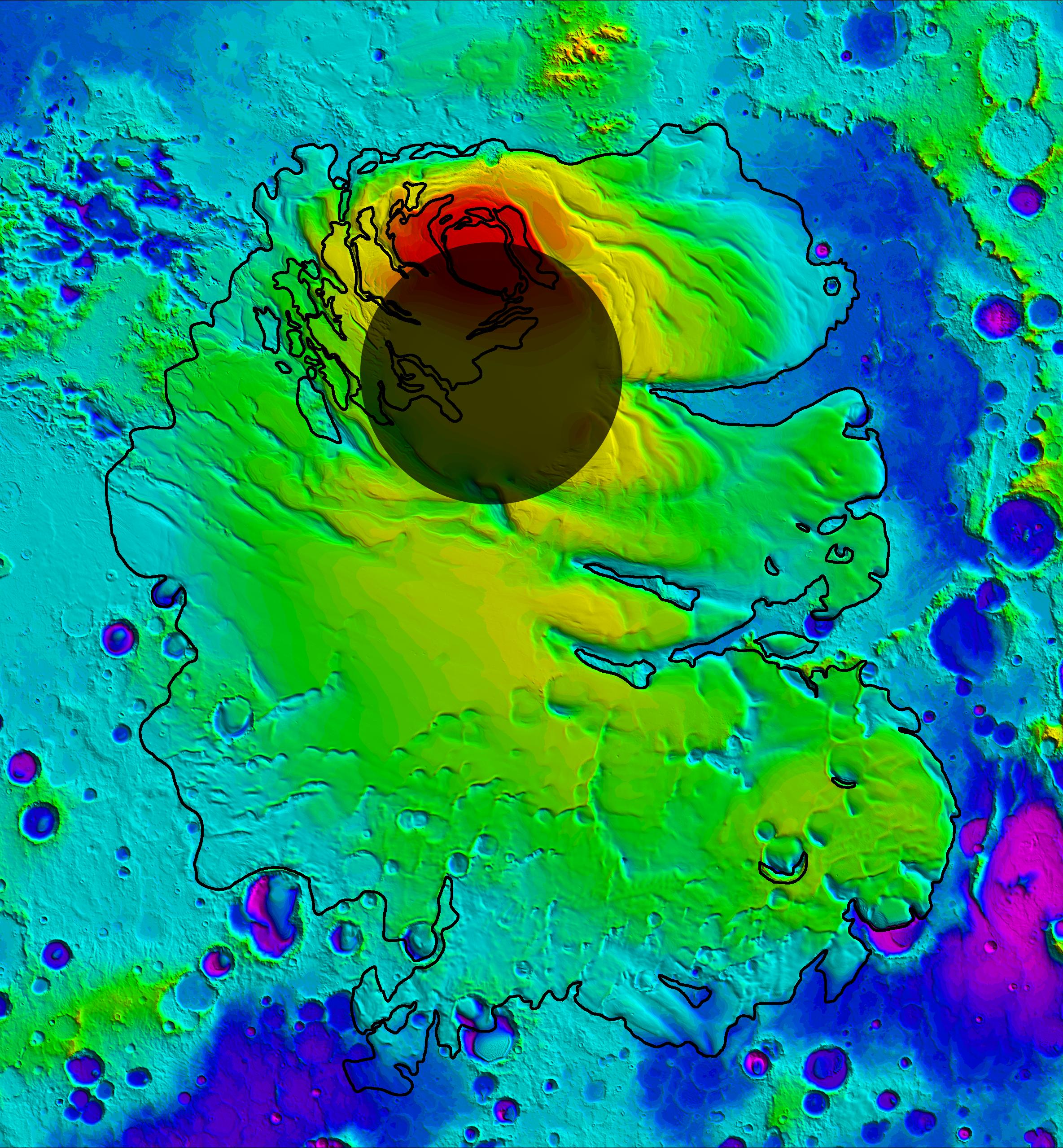
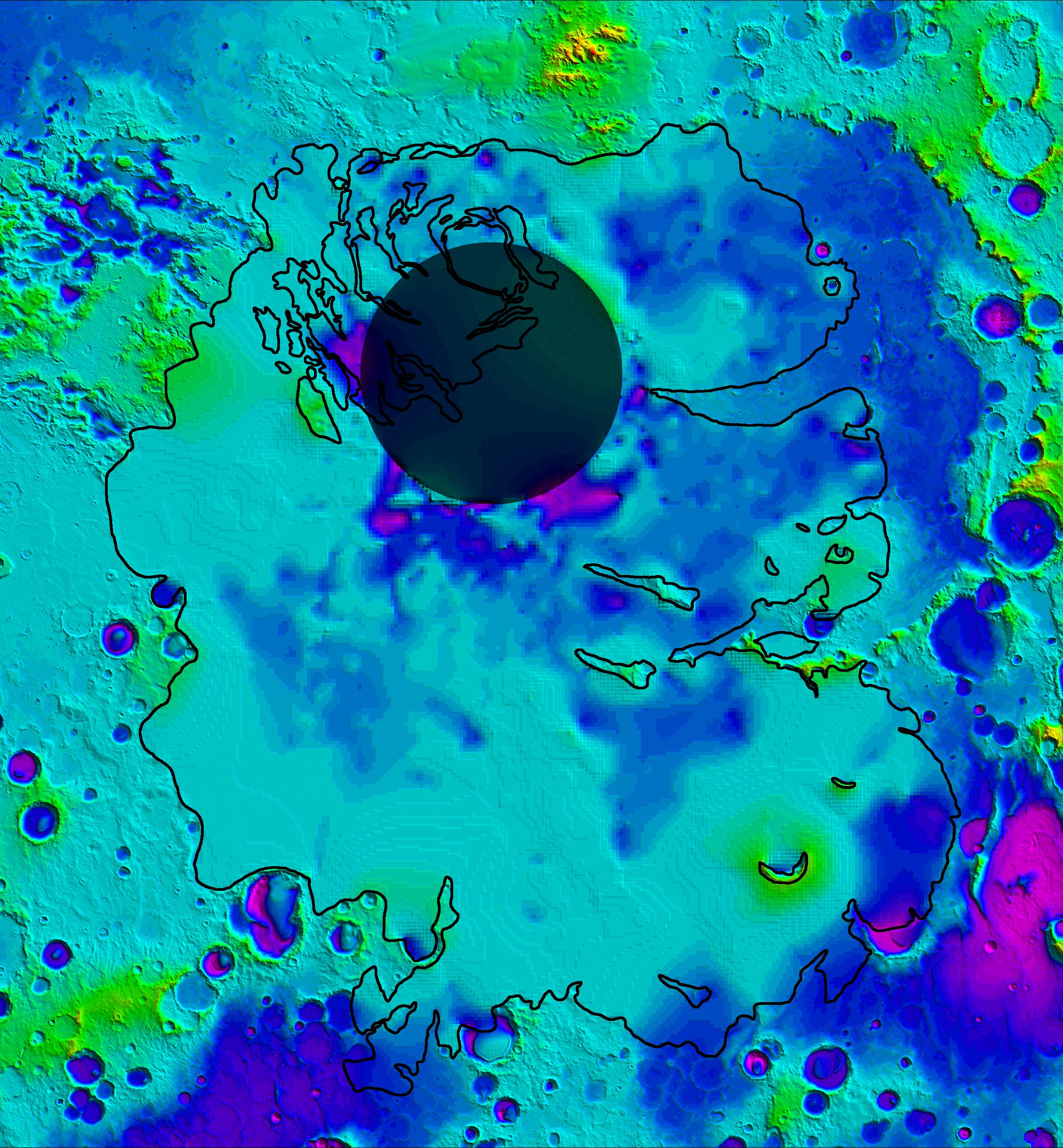
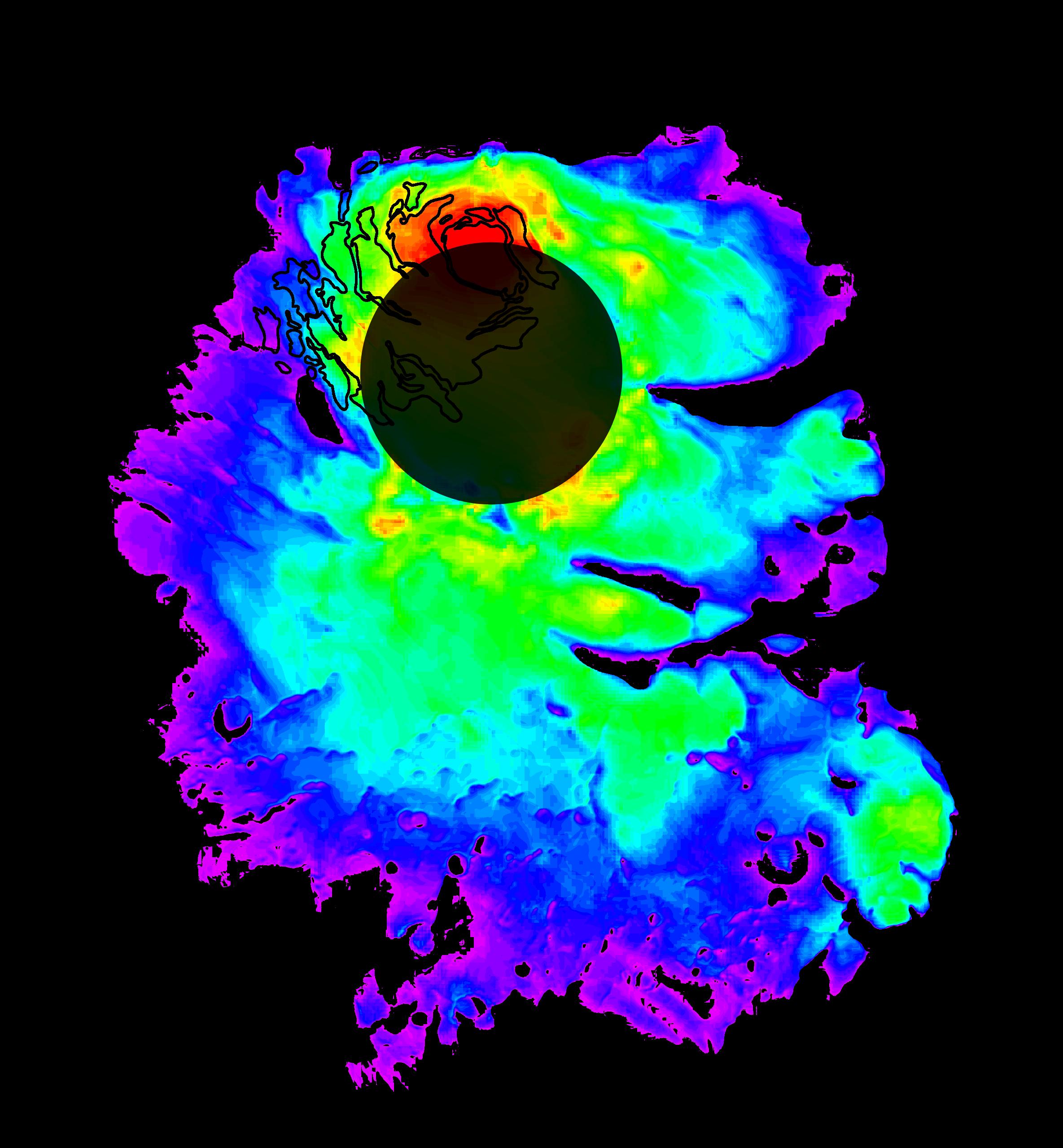
PIA23511:
-
Jezero Crater's Ancient Lakeshore
Full Resolution:
TIFF
(16.31 MB)
JPEG
(2.37 MB)
|
|
|
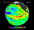
2016-09-15 |
Mars
|
2001 Mars Odyssey
Mars Global Surveyor (MGS)
|
MOLA
THEMIS
|
1726x2453x3 |
|
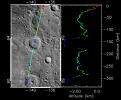
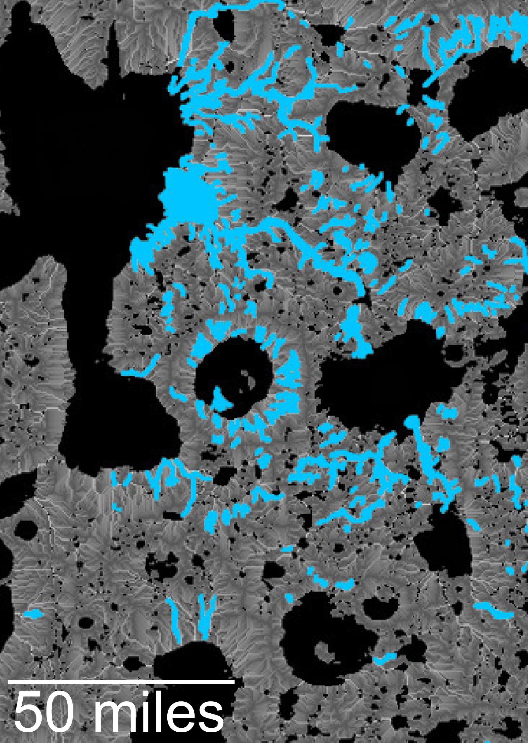
-
PIA20839:
-
Hydrologic Modeling of Relatively Recent Martian Streams and Lake
Full Resolution:
TIFF
(7.388 MB)
JPEG
(549.4 kB)
|
|
|
2016-09-15 |
Mars
|
2001 Mars Odyssey
Mars Global Surveyor (MGS)
|
MOLA
THEMIS
|
1316x1840x3 |

|
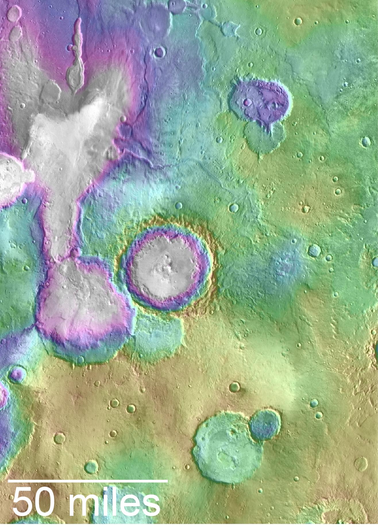
-
PIA20838:
-
Landscape of Former Lakes and Streams on Northern Mars
Full Resolution:
TIFF
(7.267 MB)
JPEG
(409.9 kB)
|
|
|
2016-03-21 |
Mars
|
2001 Mars Odyssey
Mars Global Surveyor (MGS)
Mars Reconnaissance Orbiter (MRO)
|
MOLA
|
2400x2400x3 |
|
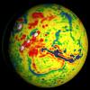
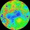
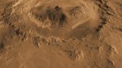
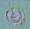
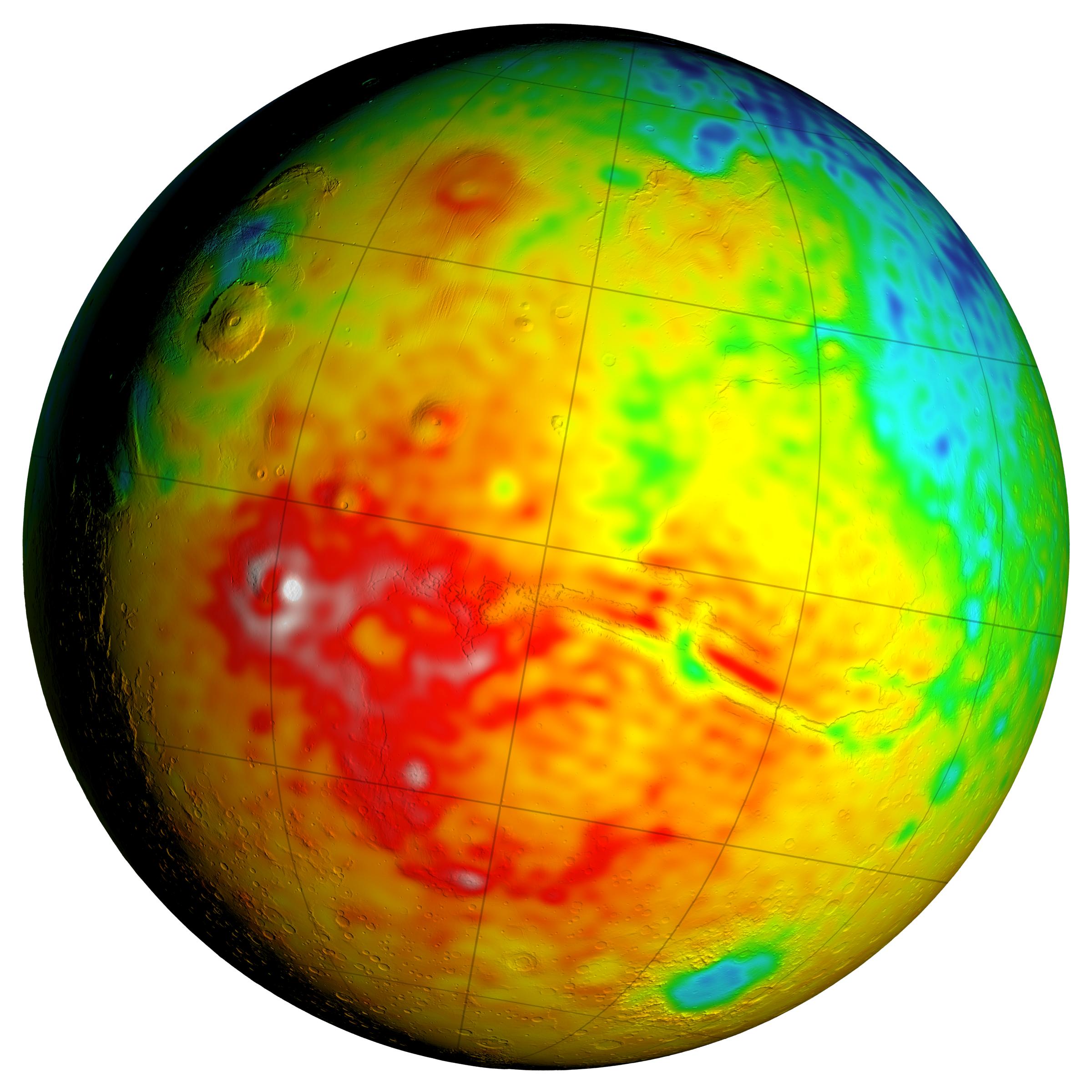
-
PIA20327:
-
Local Variations in the Gravitational Pull of Mars
Full Resolution:
TIFF
(11.91 MB)
JPEG
(443.7 kB)
|
|
|
2016-03-21 |
Mars
|
2001 Mars Odyssey
Mars Global Surveyor (MGS)
Mars Reconnaissance Orbiter (MRO)
|
MOLA
|
2400x2400x3 |

|
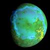
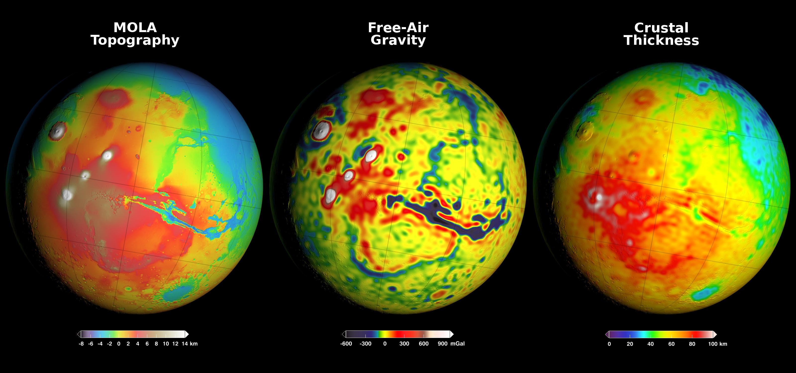
-
PIA20326:
-
Newly Detailed Map of Mars' Crustal Thickness
Full Resolution:
TIFF
(10.76 MB)
JPEG
(398.9 kB)
|
|
|
2016-03-21 |
Mars
|
2001 Mars Odyssey
Mars Global Surveyor (MGS)
Mars Reconnaissance Orbiter (MRO)
|
MOLA
|
3200x1500x3 |
|
-
PIA20277:
-
Using Gravity and Topography to Map Mars' Crustal Thickness
Full Resolution:
TIFF
(7.902 MB)
JPEG
(358.2 kB)
|
|
|
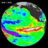
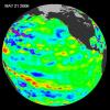
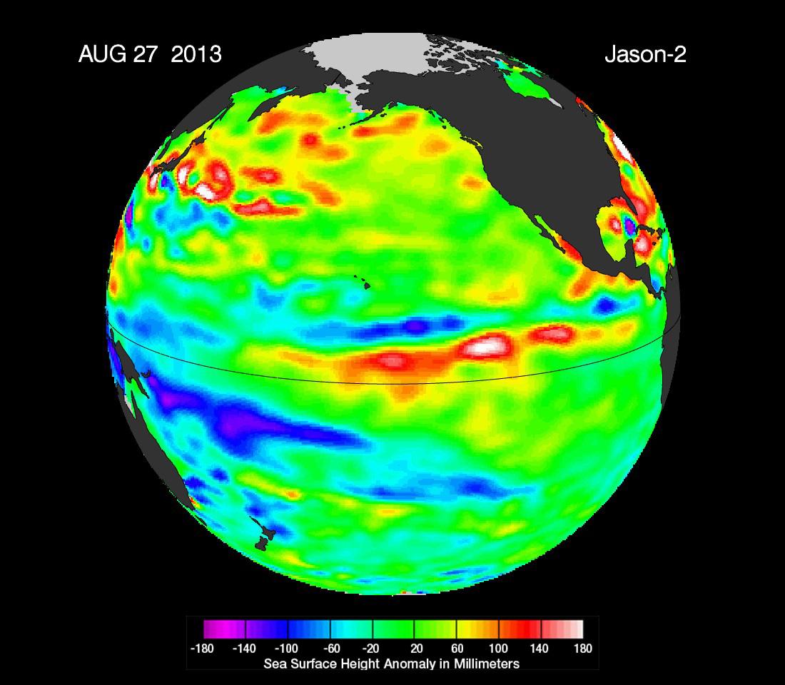
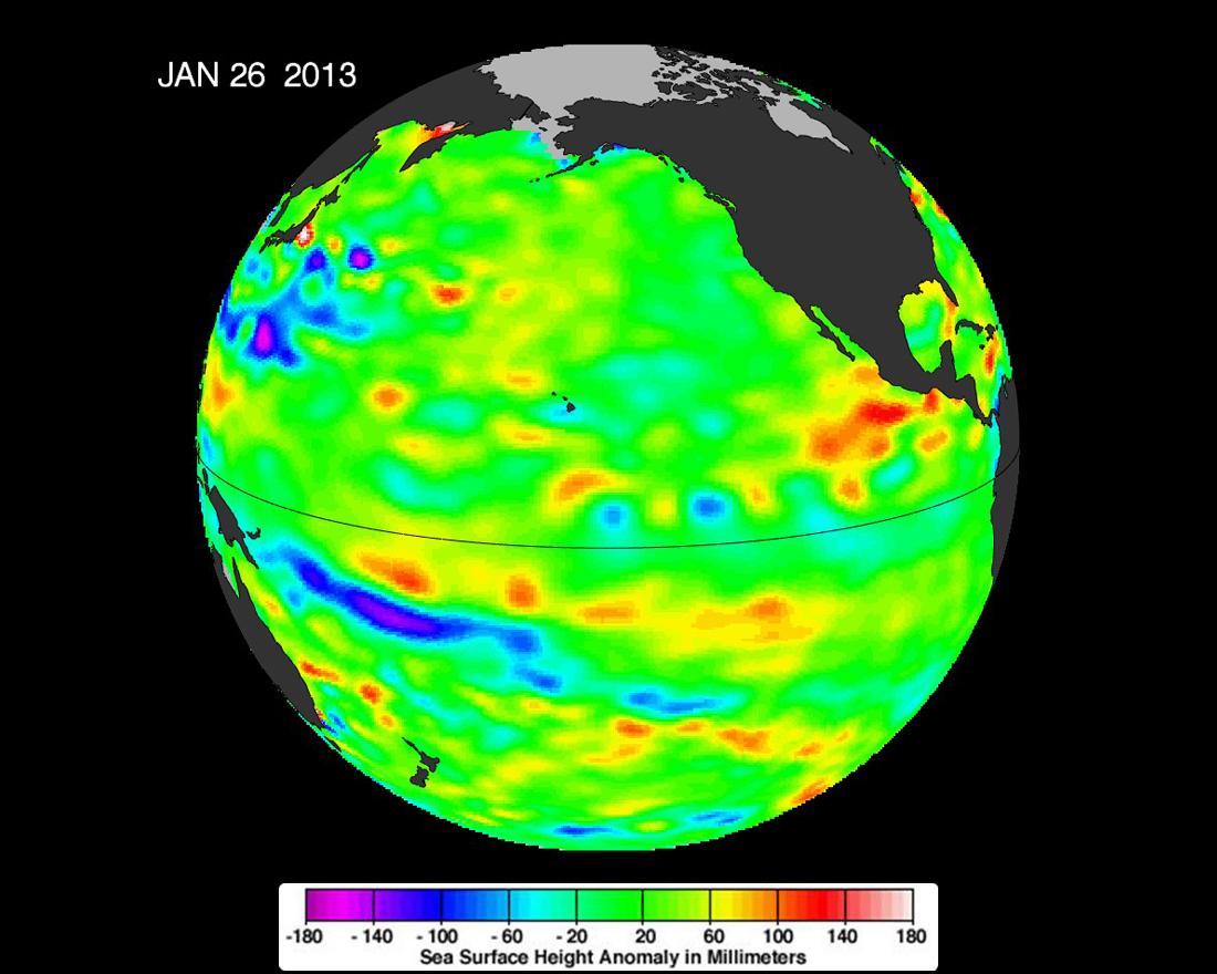
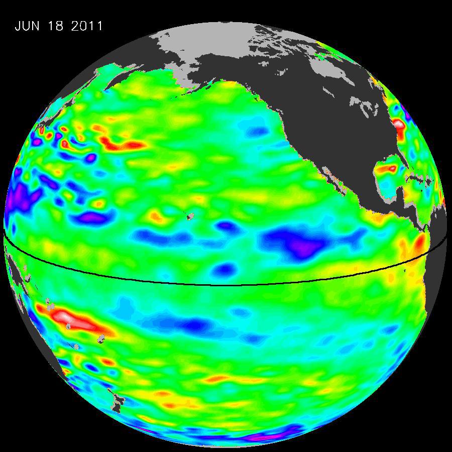
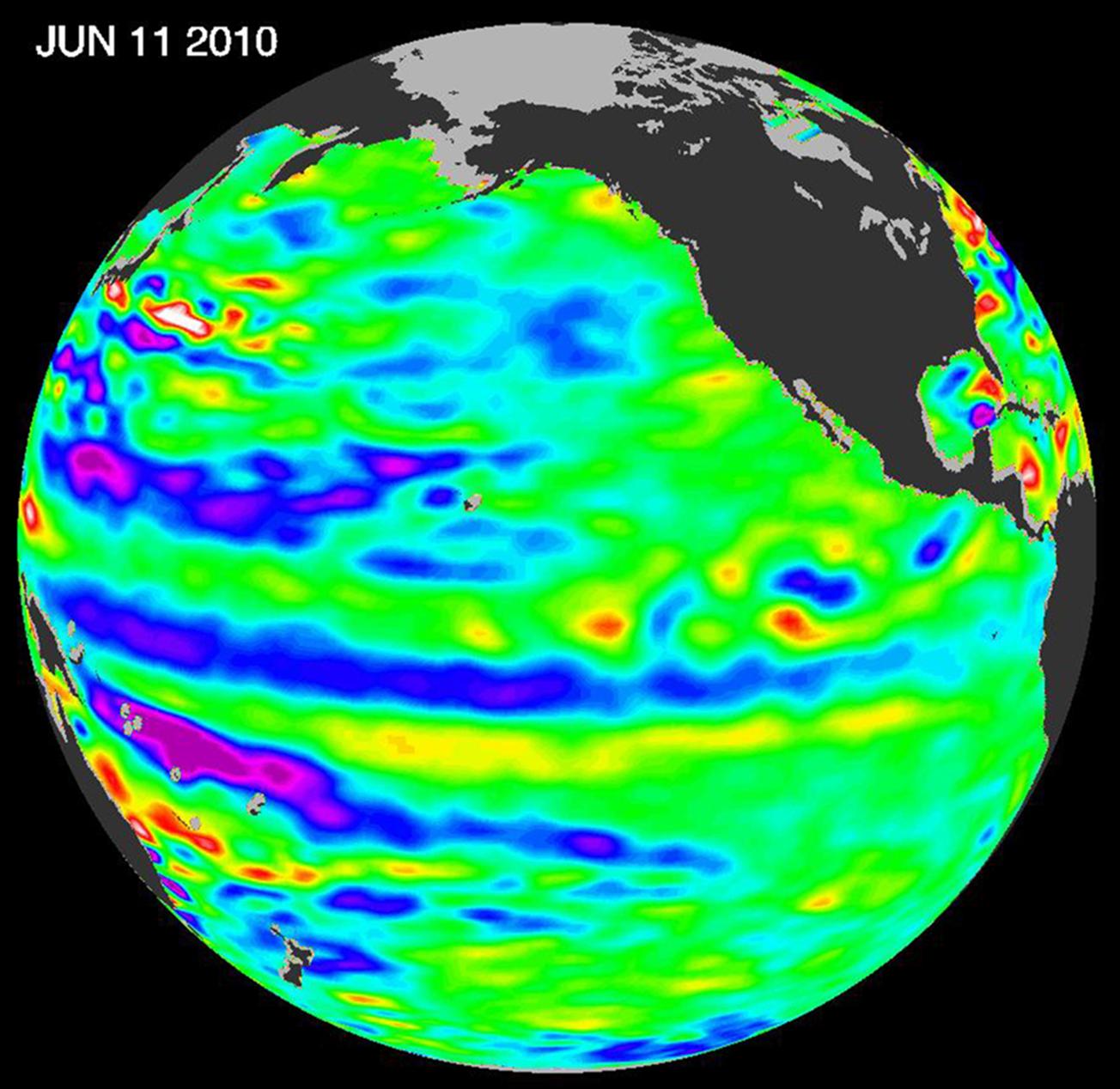
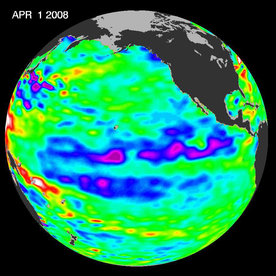
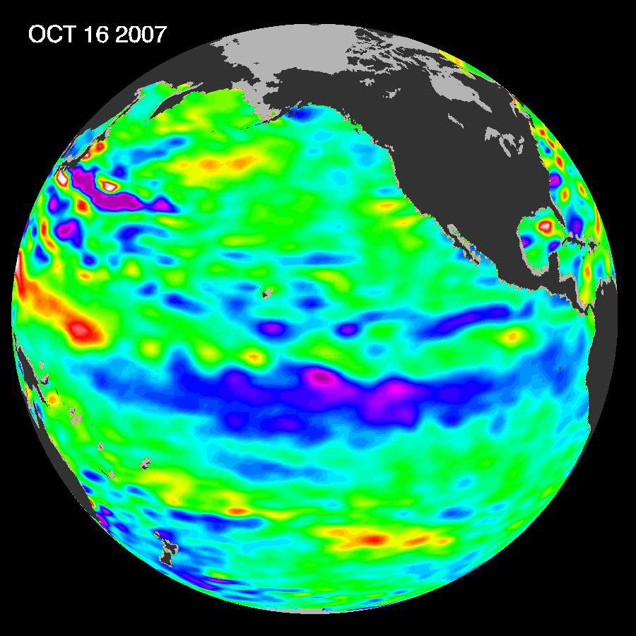
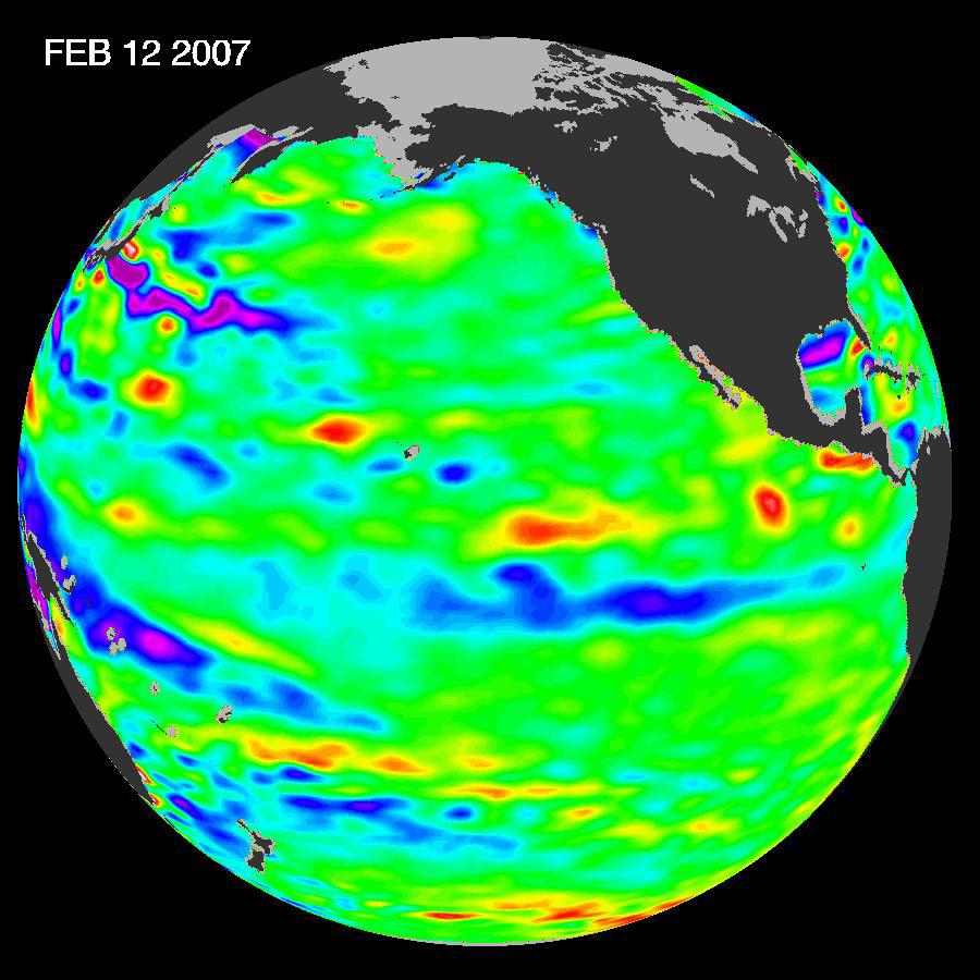
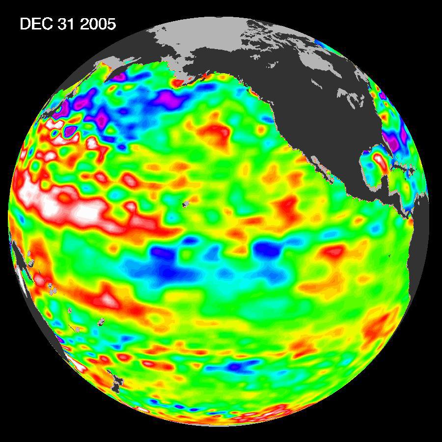
2015-10-19 |
Earth
|
OSTM/Jason-2
|
Altimeter
|
3300x1791x3 |
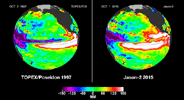
|
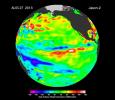
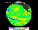
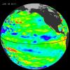
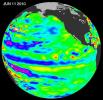
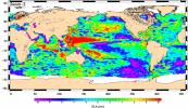
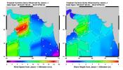
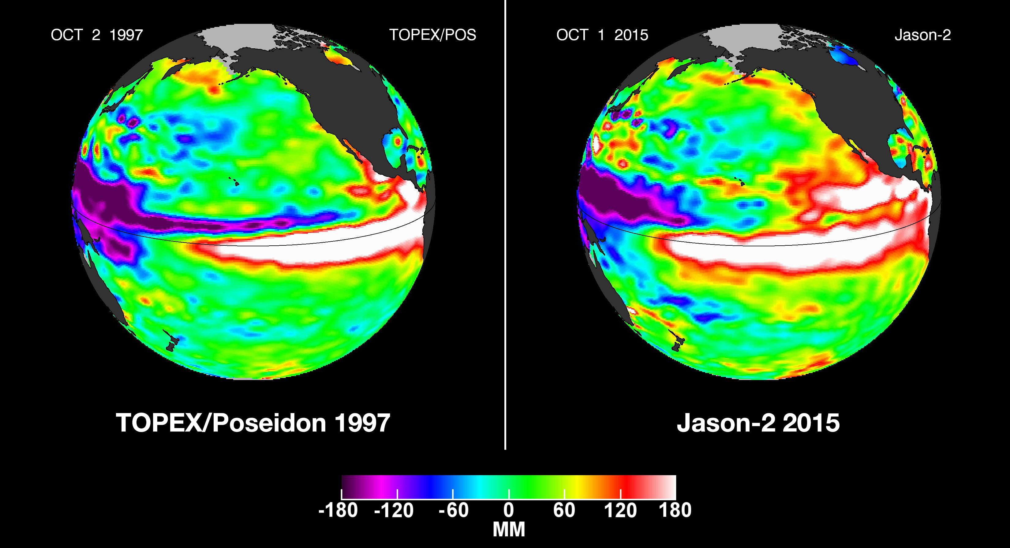
-
PIA20009:
-
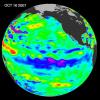
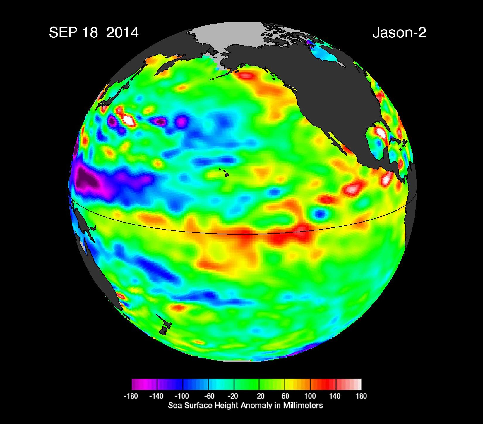
NASA Studying 2015 El Niño Event as Never Before

Full Resolution:
TIFF
(6.183 MB)
JPEG
(459.8 kB)
|
|
|
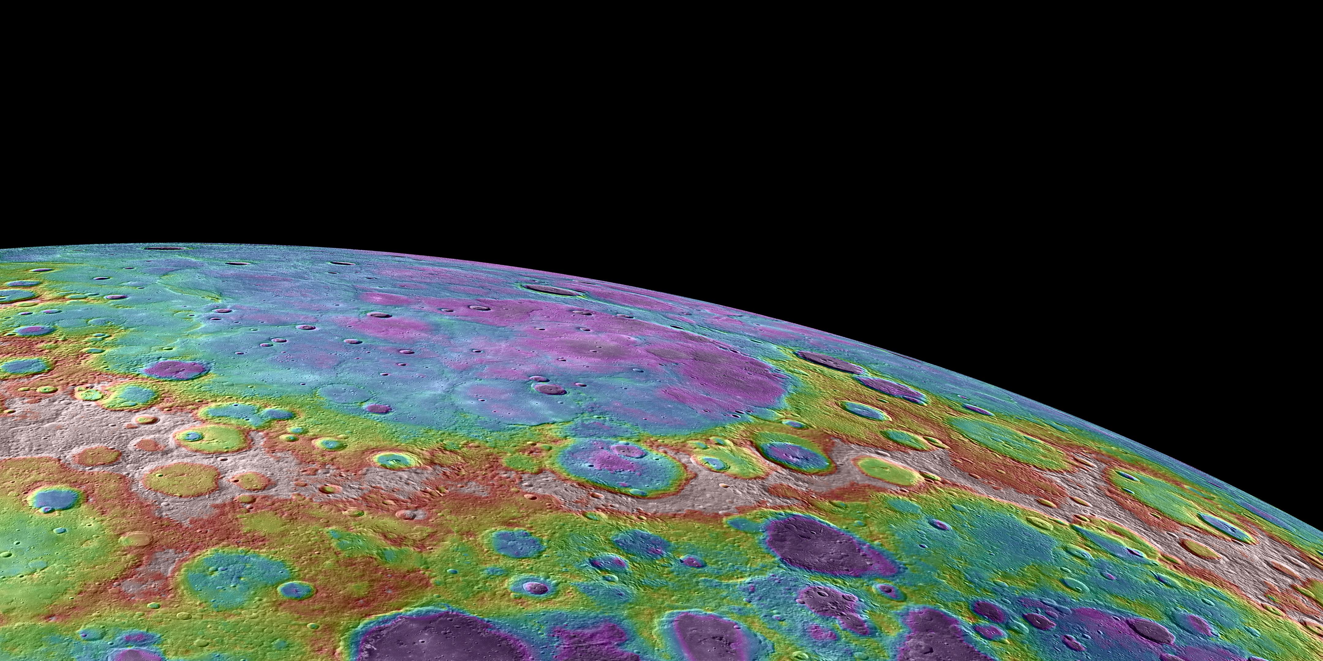
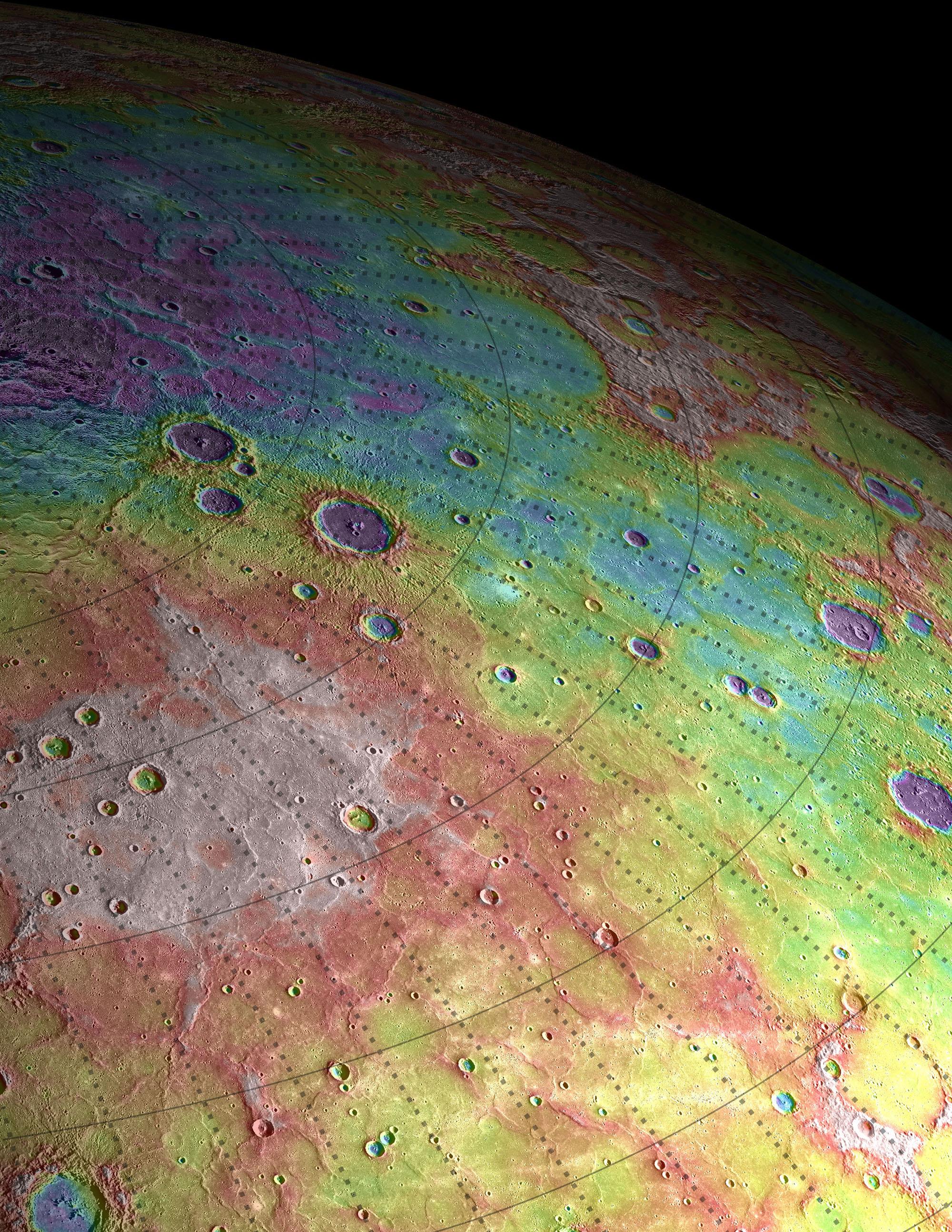
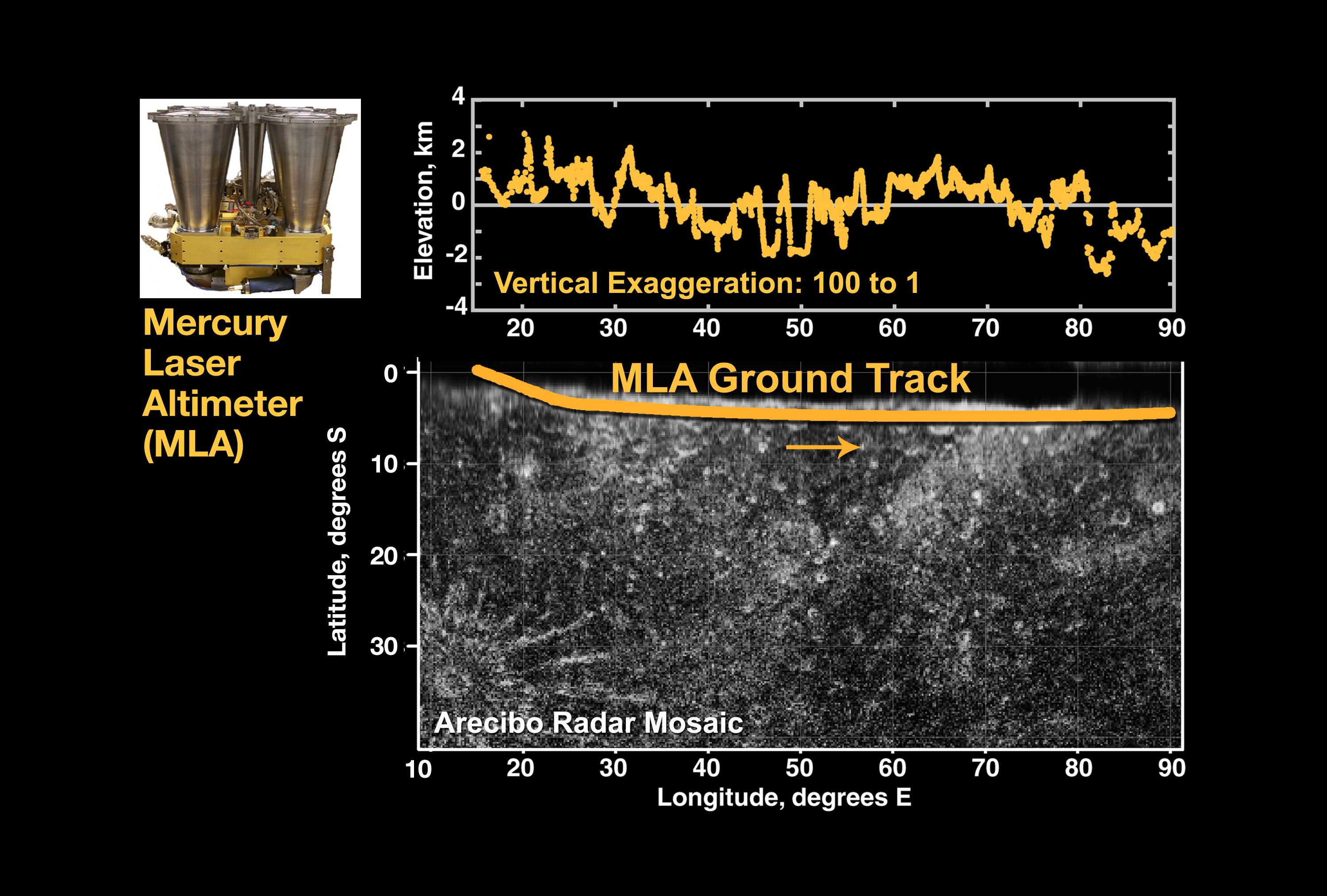
2015-05-01 |
Mercury
|
MESSENGER
|
Mercury Dual Imaging System (MDIS)
MLA
|
5057x3272x3 |
|
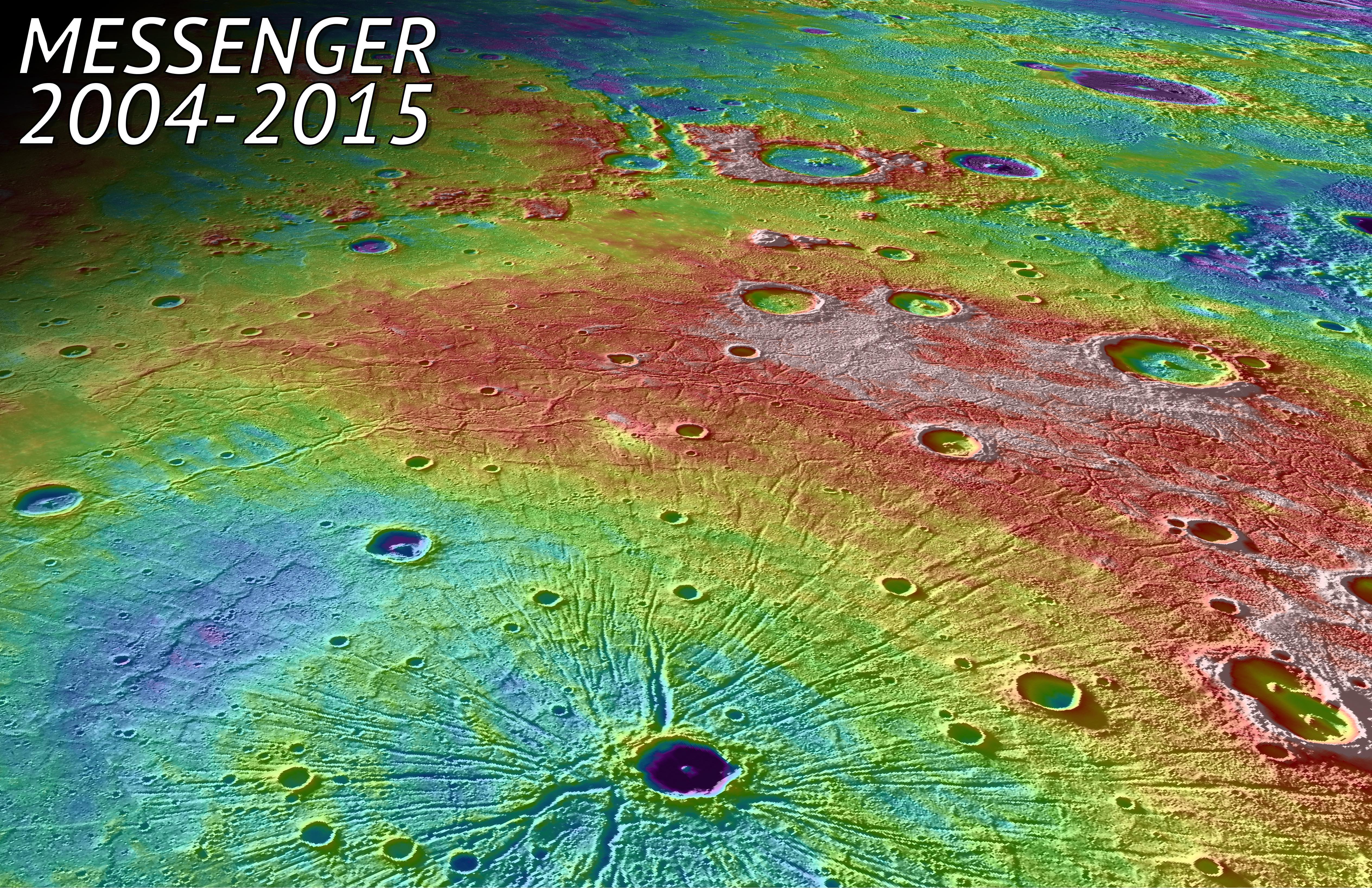
-
PIA19450:
-
In Tribute
Full Resolution:
TIFF
(49.67 MB)
JPEG
(4.768 MB)
|
|
|
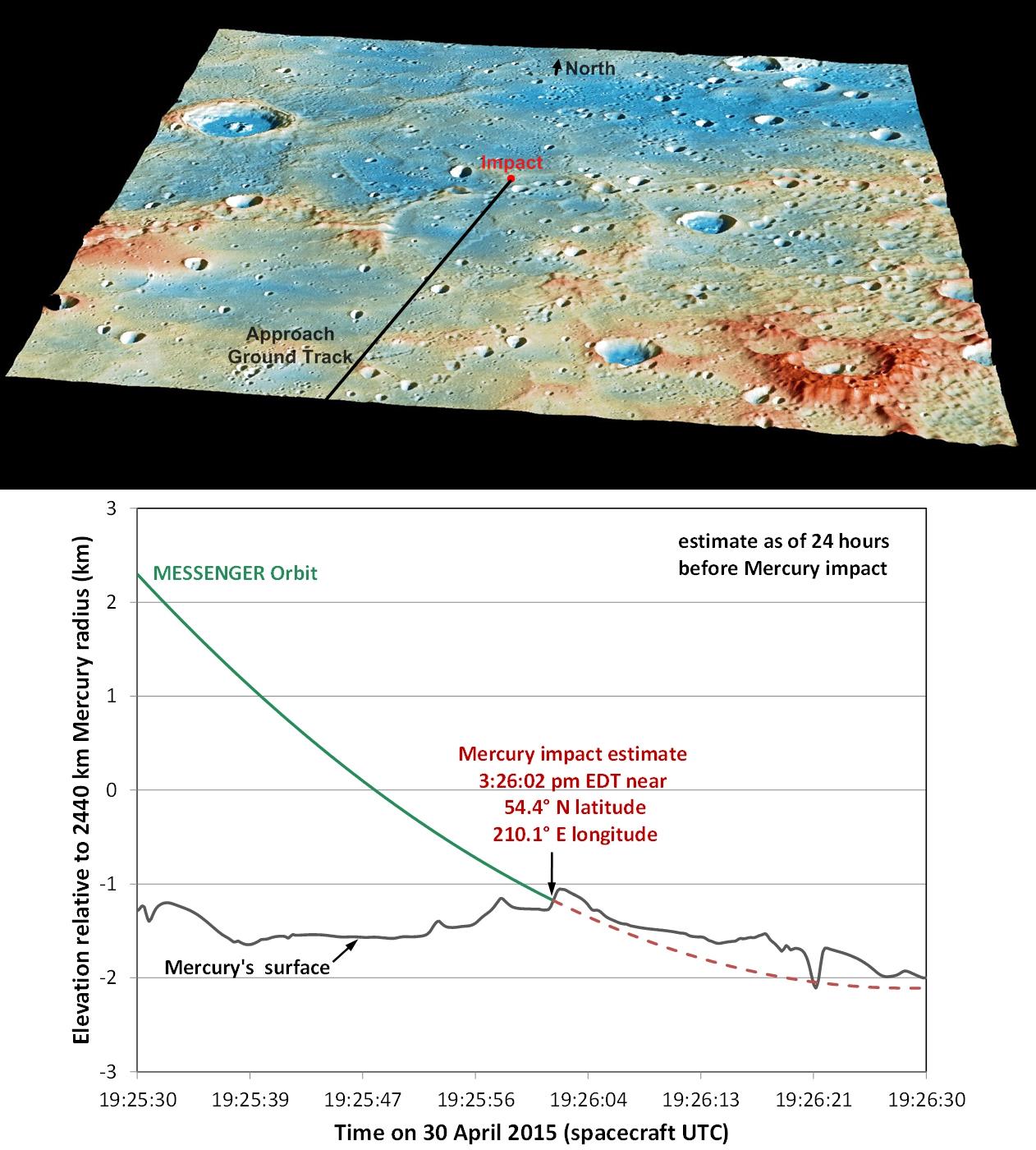
2015-04-29 |
Mercury
|
MESSENGER
|
Mercury Dual Imaging System (MDIS)
MLA
|
1846x826x3 |
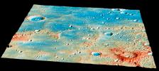
|
-
PIA19444:
-
Overview of the Impact Region
Full Resolution:
TIFF
(4.576 MB)
JPEG
(276.7 kB)
|
|
|
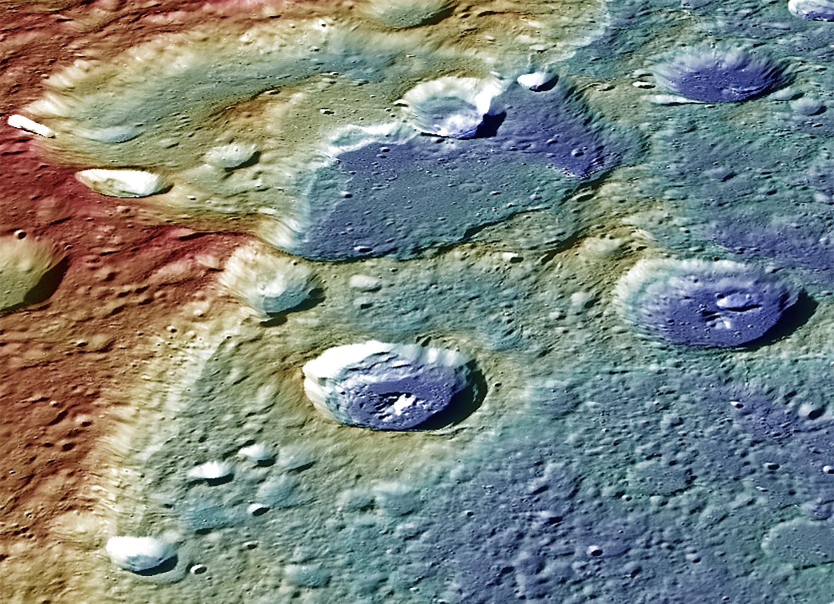
2015-04-29 |
Mercury
|
MESSENGER
|
Mercury Dual Imaging System (MDIS)
MLA
|
1262x1400x3 |
|
-
PIA19443:
-
Details of MESSENGER's Impact Location
Full Resolution:
TIFF
(5.302 MB)
JPEG
(218.3 kB)
|
|
|
2015-04-16 |
Mercury
|
MESSENGER
|
Mercury Dual Imaging System (MDIS)
MLA
|
1664x1206x3 |
|
-
PIA19422:
-
A Striking Perspective
Full Resolution:
TIFF
(6.023 MB)
JPEG
(382.6 kB)
|
|
|
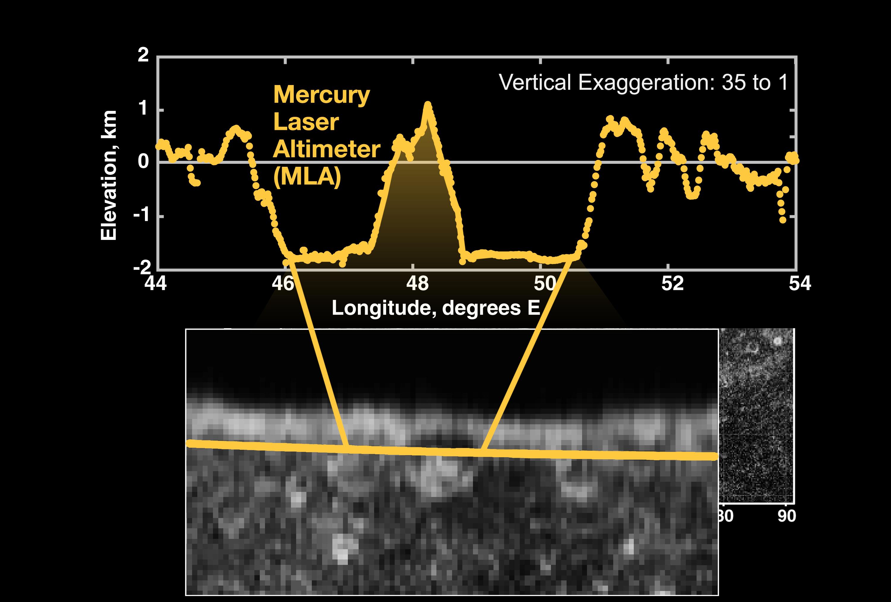
2015-04-16 |
Mercury
|
MESSENGER
|
MLA
|
3750x3752x3 |
|
-
PIA19420:
-
The Ups and Downs of Mercury's Topography
Full Resolution:
TIFF
(42.23 MB)
JPEG
(3.656 MB)
|
|
|
2014-10-01 |
Moon
|
GRAIL
Lunar Reconnaissance Orbiter (LRO)
|
Lunar Orbit Laser Altimeter
|
1500x1500x3 |
|
-
PIA18822:
-
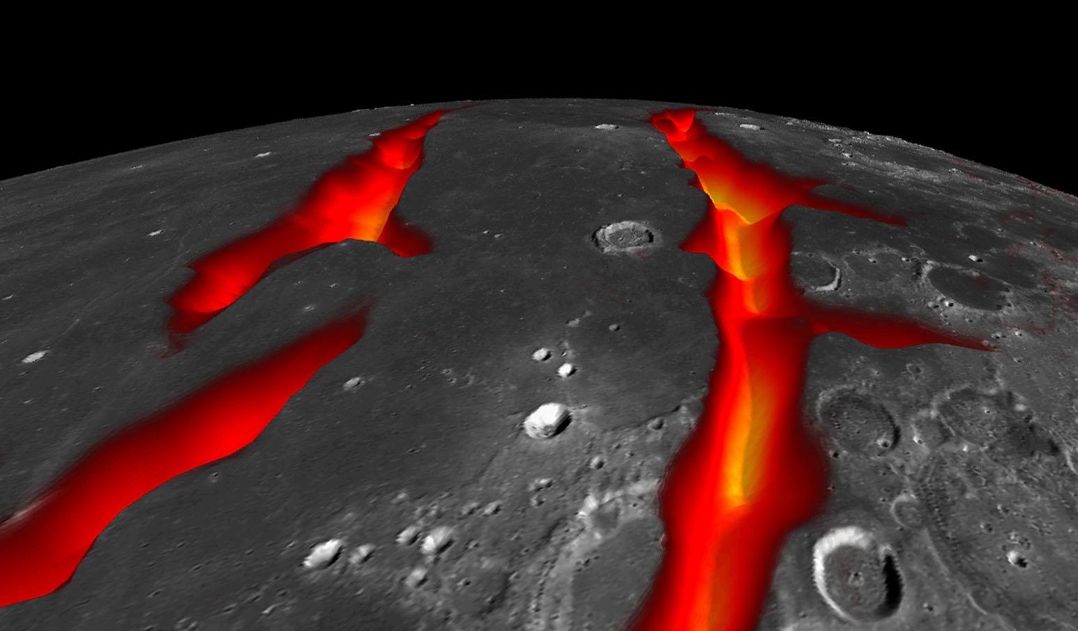
Gravity Gradients Frame Oceanus Procellarum
Full Resolution:
TIFF
(6.753 MB)
JPEG
(203.5 kB)
|
|
|
2014-10-01 |
Moon
|
GRAIL
Lunar Reconnaissance Orbiter (LRO)
|
Lunar Reconnaissance Orbiter Camera (WAC)
Lunar Orbit Laser Altimeter
|
1546x905x3 |
|
-
PIA18821:
-
On the West Coast of the Ocean of Storms (Artist's Concept)
Full Resolution:
TIFF
(4.199 MB)
JPEG
(116.7 kB)
|
|
|
2014-09-22 |
Earth
|
OSTM/Jason-2
|
Altimeter
|
1650x1450x3 |
|
-
PIA17809:
-
The Fickle El Niño of 2014
Full Resolution:
TIFF
(7.181 MB)
JPEG
(203.9 kB)
|
|
|
2014-08-15 |
Mercury
|
MESSENGER
|
MLA
|
723x571x3 |
|
-
PIA18678:
-
Simple Shapes
Full Resolution:
TIFF
(1.239 MB)
JPEG
(36.26 kB)
|
|
|
2014-07-23 |
Mercury
|
MESSENGER
|
MLA
|
1335x1026x3 |
|
-
PIA18626:
-
Peaking into the Shadows
Full Resolution:
TIFF
(4.111 MB)
JPEG
(111.5 kB)
|
|
|
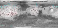
2013-12-10 |
Mars
|
2001 Mars Odyssey
Mars Global Surveyor (MGS)
|
MOLA
THEMIS
|
989x481x3 |
|
-
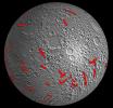
PIA17609:
-
Locations of Ice-Exposing Fresh Craters on Mars
Full Resolution:
TIFF
(1.428 MB)
JPEG
(82.32 kB)
|
|
|
2013-12-10 |
Mars
|
2001 Mars Odyssey
Mars Global Surveyor (MGS)
|
MOLA
THEMIS
|
960x665x3 |
|
-
PIA17607:
-
Maps of Recurrent Slope Linea Markings on Mars
Full Resolution:
TIFF
(1.916 MB)
JPEG
(143.3 kB)
|
|
|
2013-09-09 |
Earth
|
OSTM/Jason-2
|
Altimeter
|
1100x960x3 |
|
-
PIA17454:
-
'La Nada' Climate Pattern Lingers in the Pacific
Full Resolution:
TIFF
(3.169 MB)
JPEG
(108.7 kB)
|
|
|
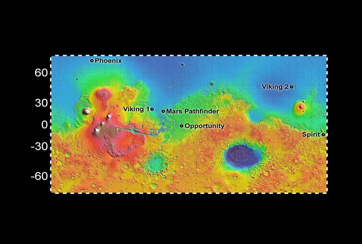
2013-09-04 |
Mars
|
InSight
Mars Global Surveyor (MGS)
|
MOLA
|
4000x2298x3 |
|
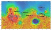
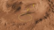
-
PIA17357:
-
NASA's Mars Landing Sites, including InSight
Full Resolution:
TIFF
(27.59 MB)
JPEG
(2.27 MB)
|
|
|
2013-07-17 |
Mercury
|
MESSENGER
|
MLA
|
1536x1536x3 |
|
-
PIA17385:
-
Digital Elevation Model of Mercury's Northern Hemisphere
Full Resolution:
TIFF
(2.364 MB)
JPEG
(289.2 kB)
|
|
|
2013-07-11 |
Mercury
|
MESSENGER
|
Mercury Dual Imaging System (MDIS)
MLA
|
1150x600x3 |

|
-
PIA17379:
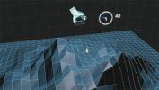
-
New QuickMap Feature: 3-D!
Full Resolution:
TIFF
(2.071 MB)
JPEG
(120.9 kB)
|
|
|
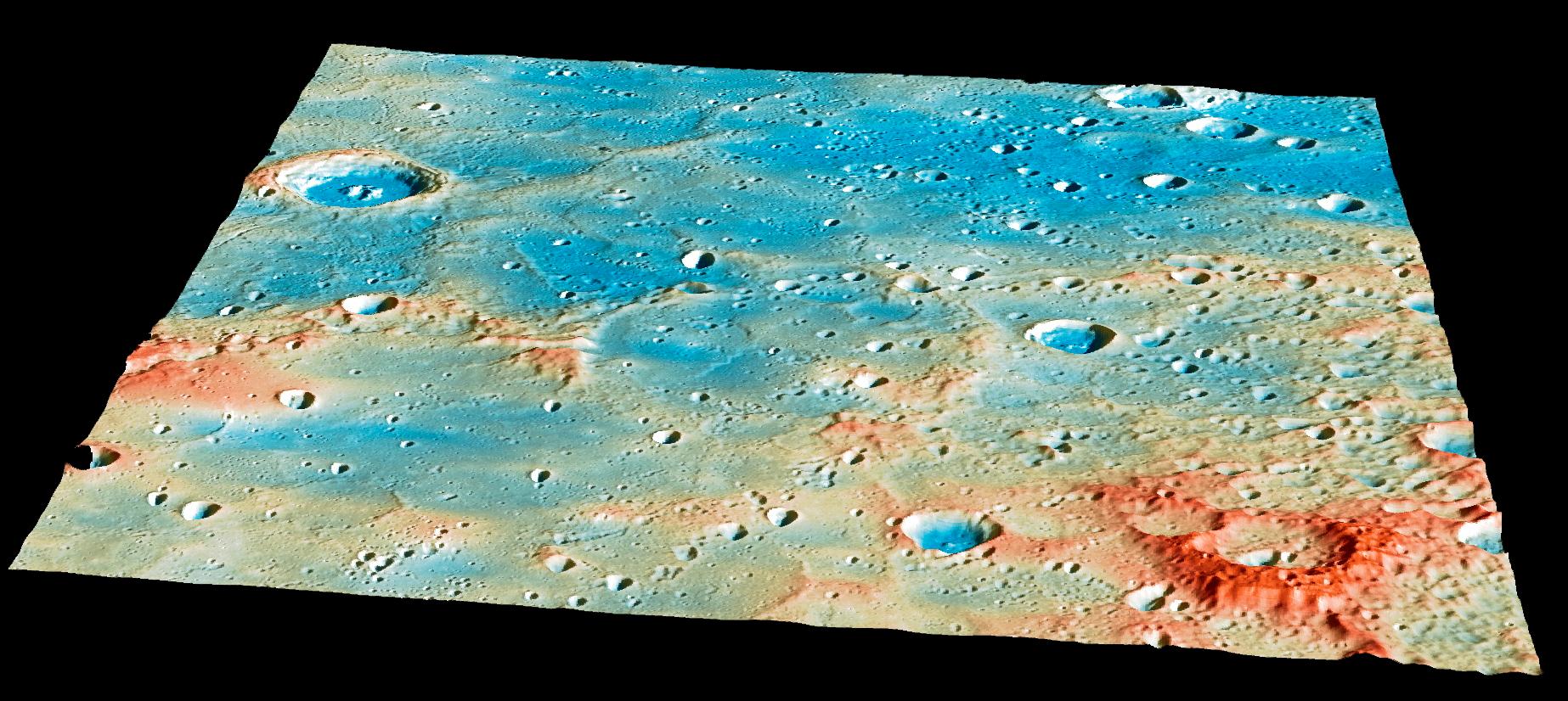
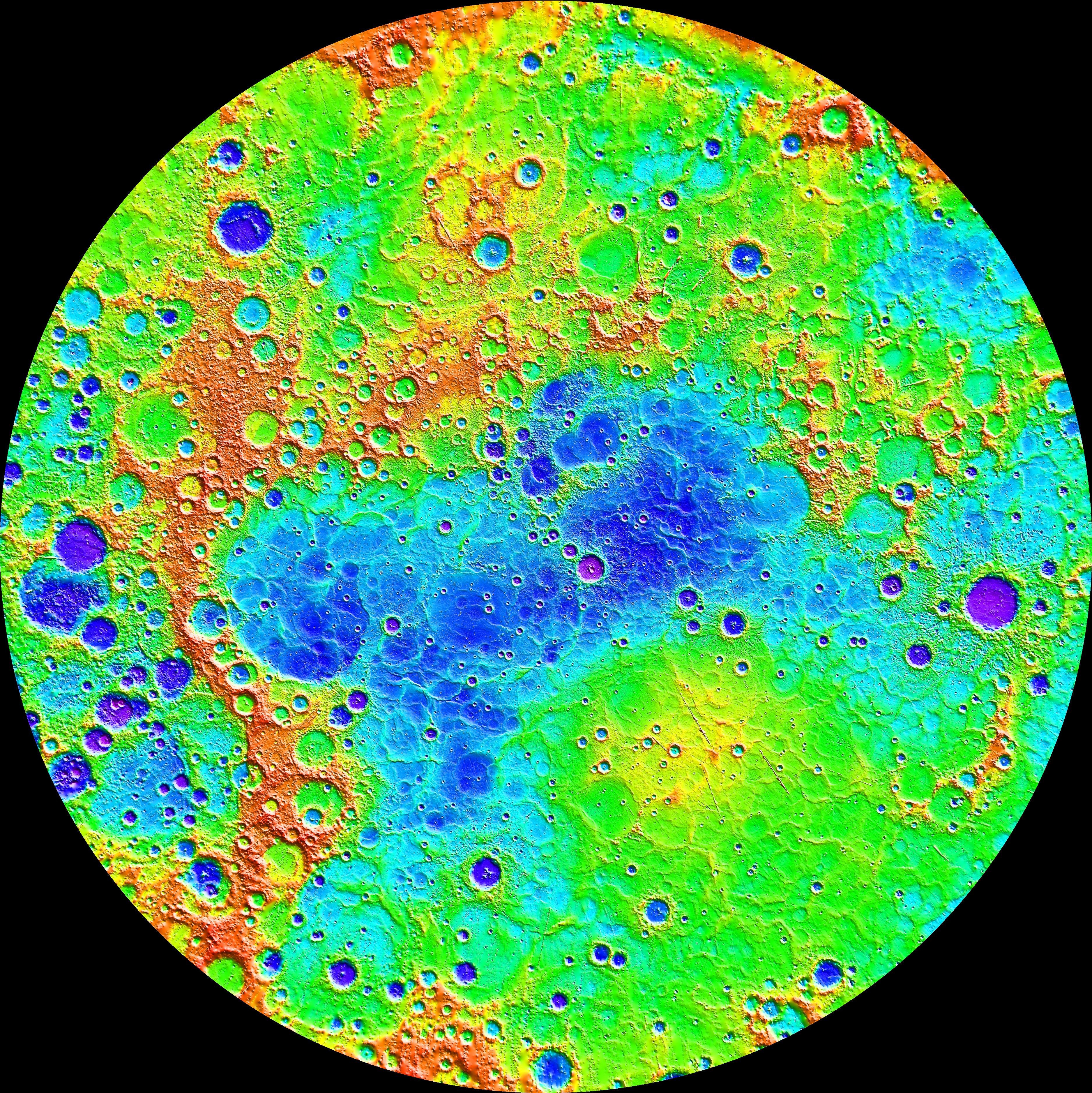
2013-04-09 |
Mercury
|
MESSENGER
|
MLA
|
1082x1082x3 |
|
-
PIA16951:
-
Northern Topography
Full Resolution:
TIFF
(3.514 MB)
JPEG
(398.8 kB)
|
|
|
2013-02-07 |
Earth
|
OSTM/Jason-2
|
Altimeter
|
1100x880x3 |
|
-
PIA16787:
-
Pacific Locked in 'La Nada' Limbo
Full Resolution:
TIFF
(2.905 MB)
JPEG
(93.08 kB)
|
|
|
2012-12-05 |
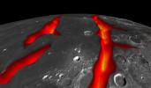
Moon
|
GRAIL
Lunar Reconnaissance Orbiter (LRO)
|
Lunar Orbiter Laser Altimeter
|
1690x1623x3 |
|
-
PIA16584:
-
Moon Dike Map
Full Resolution:
TIFF
(8.232 MB)
JPEG
(590.6 kB)
|
|
|
2012-12-03 |
|
MESSENGER
|
MLA
|
580x325x1 |

|
-
PIA16530:
-
A Solar Day at Prokofiev Crater
Full Resolution:
TIFF
(188.9 kB)
JPEG
(47.11 kB)
|
|
|
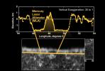
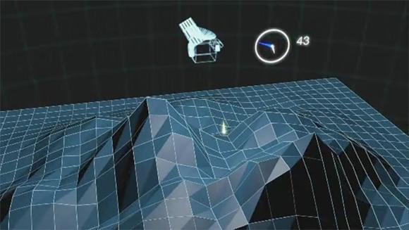
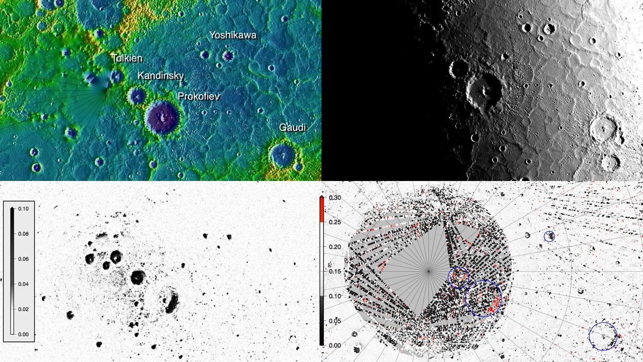
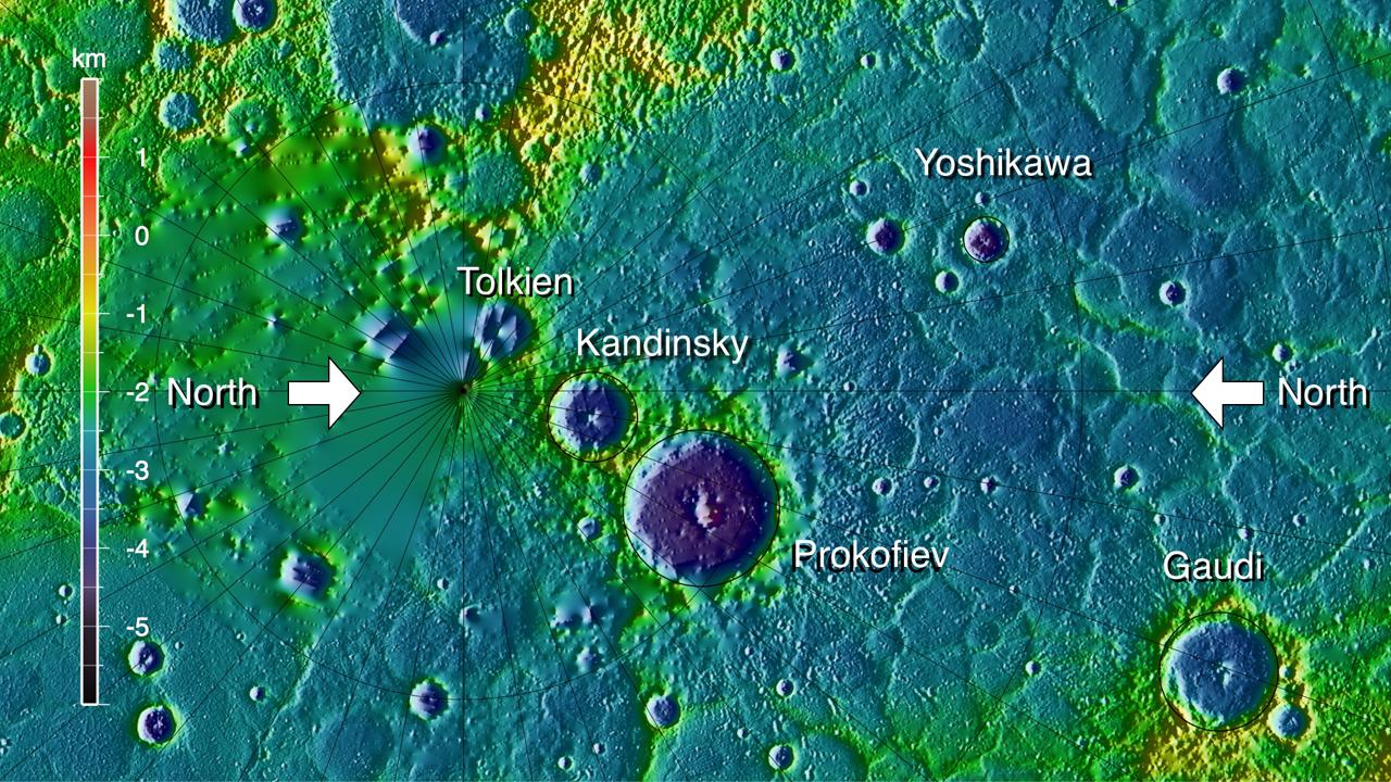
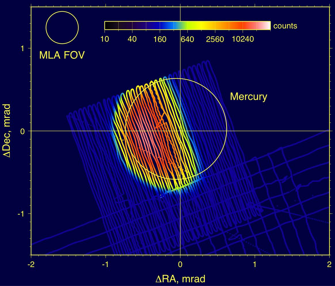
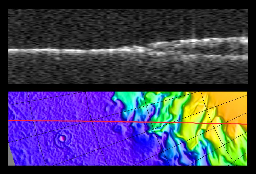
2012-12-03 |
|
MESSENGER
|
MLA
|
580x327x3 |
|
-
PIA16529:
-
How MLA Works
Full Resolution:
TIFF
(569.4 kB)
JPEG
(29.2 kB)
|
|
|
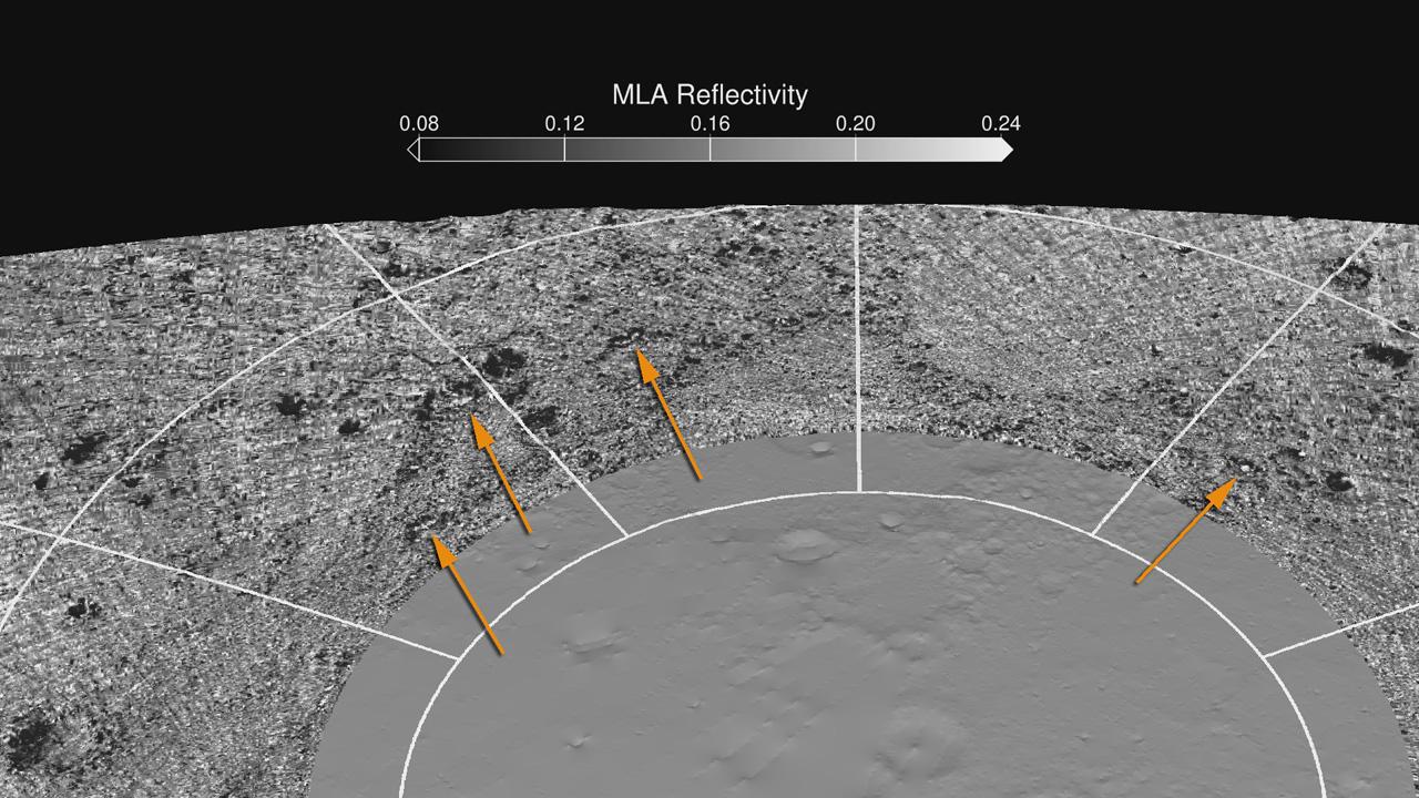
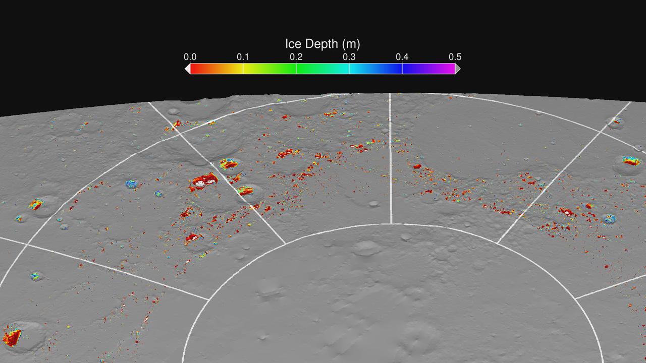
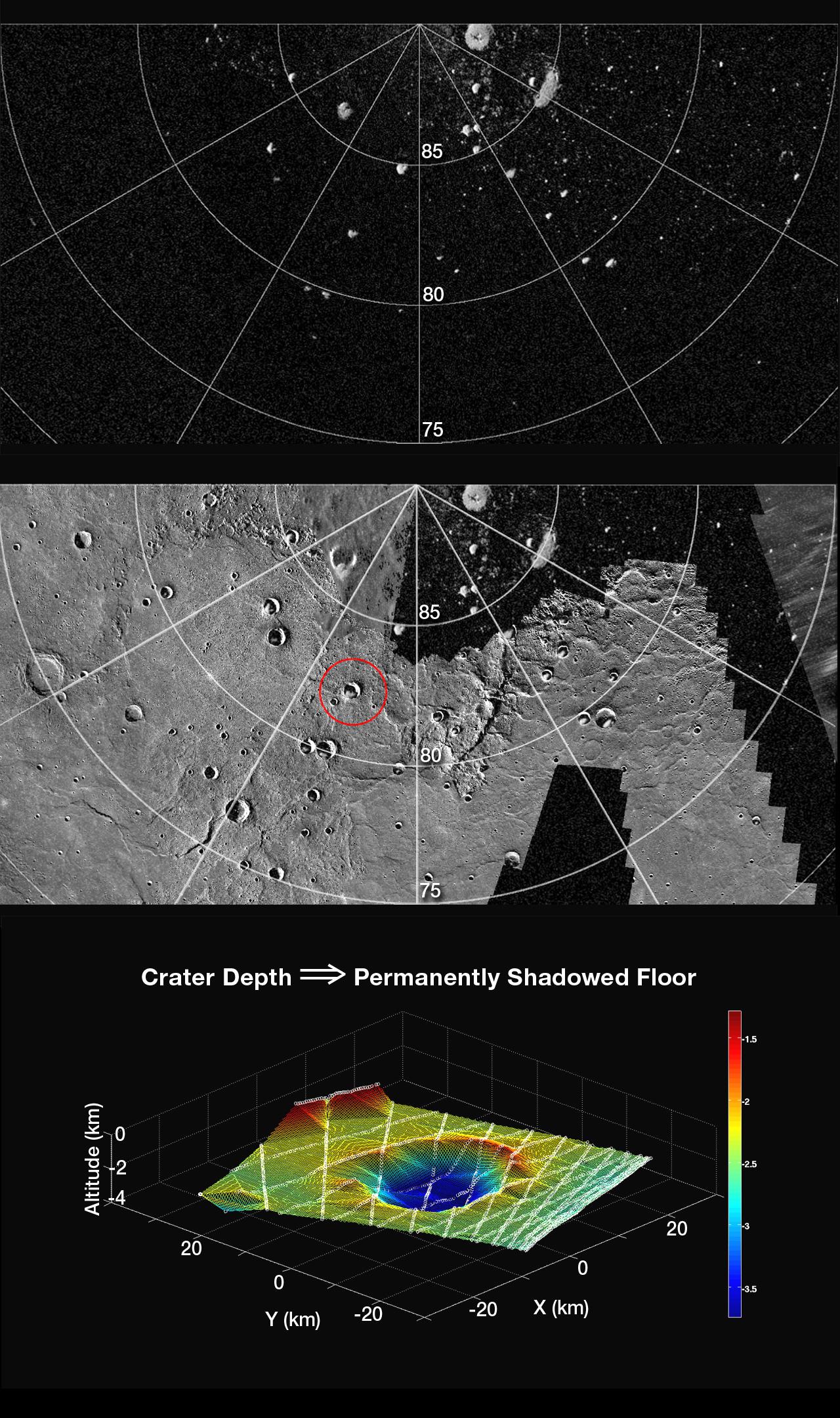
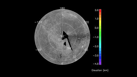
2012-11-30 |
Mercury
|
MESSENGER
|
MLA
|
1280x720x3 |
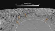
|
-
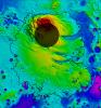
PIA16527:
-
MLA Reflectivity near the North Pole
Full Resolution:
TIFF
(2.766 MB)
JPEG
(174 kB)
|
|
|
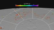
2012-11-30 |
Mercury
|
MESSENGER
|
MLA
|
1280x720x3 |
|
-
PIA16525:
-
Maximum Surface Temperature near the North Pole
Full Resolution:
TIFF
(2.766 MB)
JPEG
(168.8 kB)
|
|
|
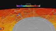
2012-11-29 |
Mercury
|
MESSENGER
|
MLA
|
1280x720x3 |
|
-
PIA16522:
-
MLA Montage
Full Resolution:
TIFF
(2.766 MB)
JPEG
(241.8 kB)
|
|
|
2012-11-29 |
Mercury
|
MESSENGER
|
MLA
|
1280x720x3 |
|
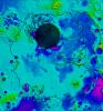
-
PIA16521:
-
Modeling Ice Stability
Full Resolution:
TIFF
(2.766 MB)
JPEG
(98.78 kB)
|
|
|
2012-11-29 |
Mercury
|
MESSENGER
|
MLA
|
1280x720x3 |
|
-
PIA16518:
-
MLA Surface Reflectance
Full Resolution:
TIFF
(2.766 MB)
JPEG
(267.5 kB)
|
|
|
2012-11-29 |
Mercury
|
MESSENGER
|
MLA
|
1280x720x3 |

|
-
PIA16516:
-
Polar Topography
Full Resolution:
TIFF
(2.766 MB)
JPEG
(264.2 kB)
|
|
|
2012-10-17 |
Earth
|
Jason-1 (Topex/Poseidon)
OSTM/Jason-2
|
Altimeter
|
1384x858x3 |
|
-
PIA16294:
-
After Brief Dip, Global Mean Sea Level Resumes Climb
Full Resolution:
TIFF
(3.564 MB)
JPEG
(143.3 kB)
|
|
|
2012-08-23 |
Mercury
|
MESSENGER
|
MDIS - Wide Angle
MLA
|
4320x2160x3 |
|
-
PIA16388:
-
Lowlands in Mercury's North
Full Resolution:
TIFF
(28.01 MB)
JPEG
(1.391 MB)
|
|
|
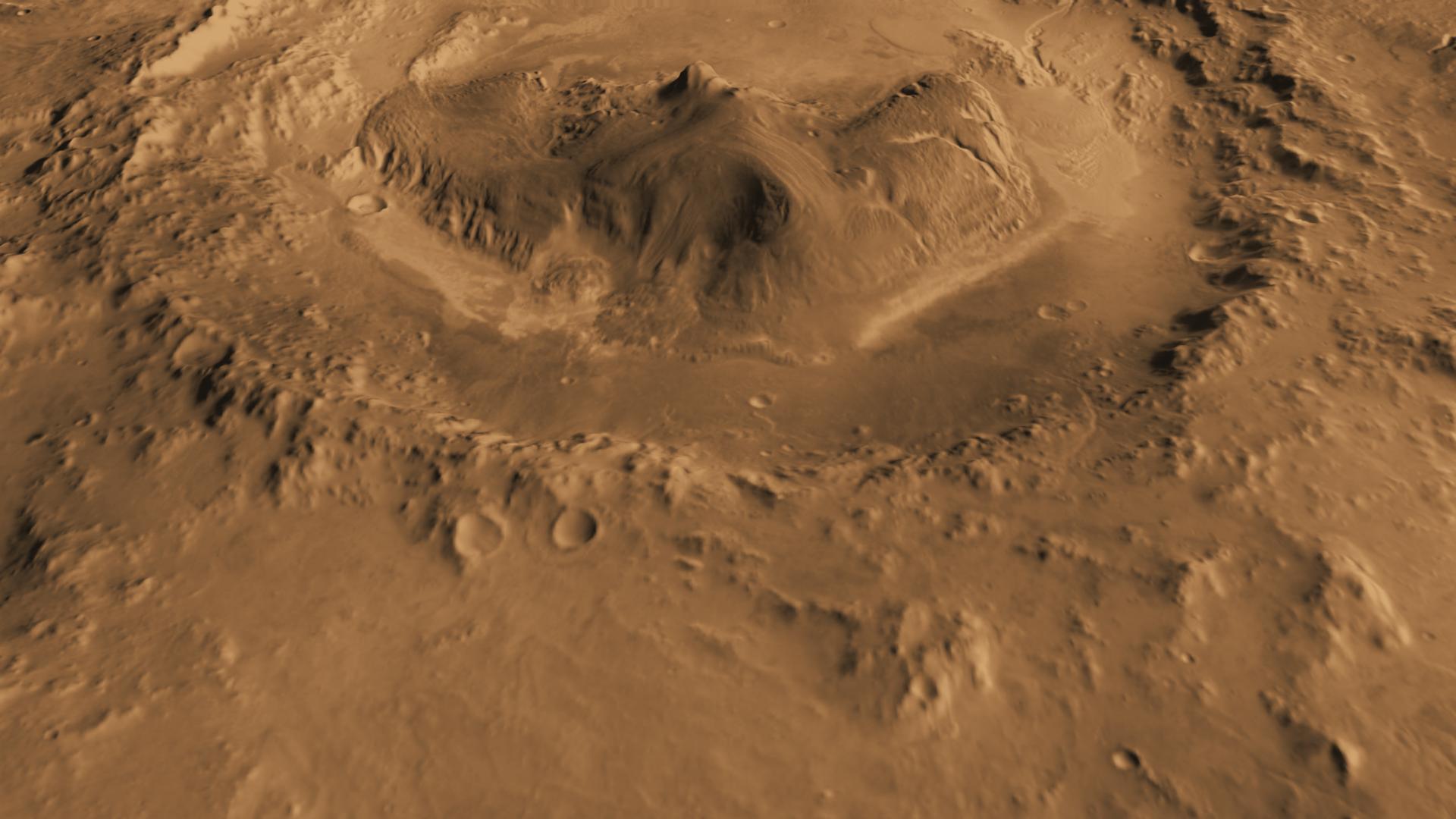
2012-08-02 |
Mars
|
Mars Science Laboratory (MSL)
|
MOLA
|
718x468x3 |
|
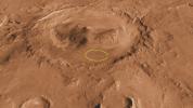
-
PIA15958:
-
Gale Crater is Low on Mars
Full Resolution:
TIFF
(1.009 MB)
JPEG
(76.15 kB)
|
|
|
2012-03-22 |
Mercury
|
MESSENGER
|
MLA
|
2000x2588x3 |
|
-
PIA15536:
-
Highs and Lows of Goethe
Full Resolution:
TIFF
(15.55 MB)
JPEG
(1.103 MB)
|
|
|
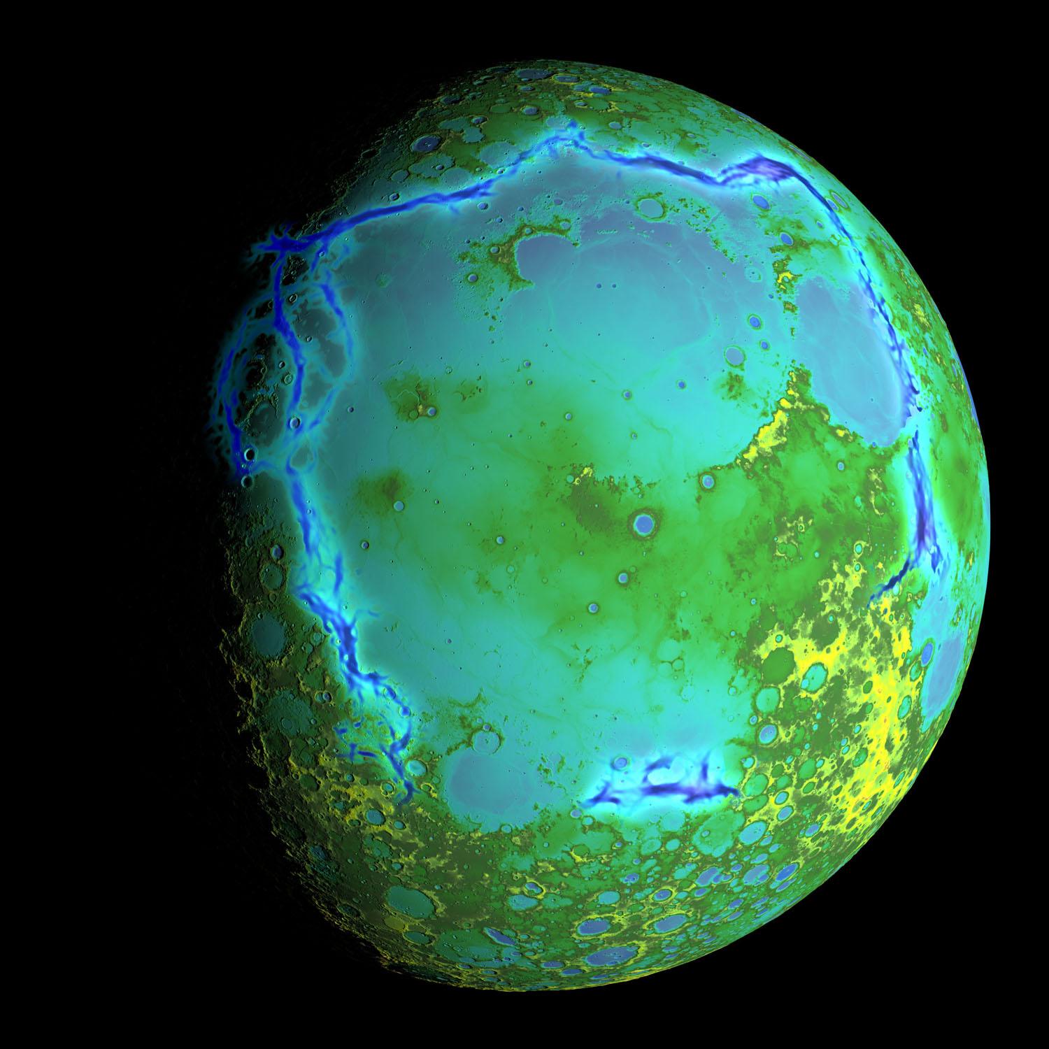
2012-03-22 |
Mercury
|
MESSENGER
|
MLA
|
2000x2588x3 |
|
-
PIA15534:
-
Perspective View of Mercury's Topography
Full Resolution:
TIFF
(15.55 MB)
JPEG
(1.278 MB)
|
|
|
2012-03-21 |
Mercury
|
MESSENGER
|
MLA
|
618x1048x3 |
|
-
PIA15531:
-
Tilted Craters in Caloris
Full Resolution:
TIFF
(1.945 MB)
JPEG
(92.34 kB)
|
|
|
2012-03-21 |
Mercury
|
MESSENGER
|
MLA
|
760x780x3 |
|
-
PIA15529:
-
Mercury's Topography from MLA
Full Resolution:
TIFF
(1.781 MB)
JPEG
(128.3 kB)
|
|
|
2011-12-19 |
Mars
|
Mars Express (MEX)
Mars Global Surveyor (MGS)
|
MARSIS
MOLA
|
1157x577x3 |

|
-
PIA15117:
-
Radargram of Mars North Polar Plateau from Mars Express
Full Resolution:
TIFF
(2.005 MB)
JPEG
(120 kB)
|
|
|
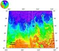
2011-11-21 |
Mars
|
Mars Global Surveyor (MGS)
|
MOLA
|
989x632x3 |
|
-
PIA15094:
-
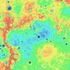
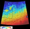
Topography of Mars
Full Resolution:
TIFF
(1.878 MB)
JPEG
(81.25 kB)
|
|
|
2011-07-22 |
Mars
|
Mars Science Laboratory (MSL)
|
MOLA
THEMIS
|
1920x1080x3 |
|
-
PIA14295:
-
Canyons on Mountain Inside Gale Crater
Full Resolution:
TIFF
(6.23 MB)
JPEG
(153.3 kB)
|
|
|
2011-07-22 |
Mars
|
Mars Science Laboratory (MSL)
|
MOLA
THEMIS
|
1920x1080x3 |
|
-
PIA14294:
-
Context of Curiosity Landing Site in Gale Crater
Full Resolution:
TIFF
(6.23 MB)
JPEG
(199 kB)
|
|
|
2011-07-22 |
Mars
|
Mars Science Laboratory (MSL)
|
MOLA
|
9600x5400x3 |
|
-
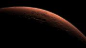
PIA14293:
-
Daybreak at Gale Crater
Full Resolution:
TIFF
(155.5 MB)
JPEG
(1.911 MB)
|
|
|
2011-07-22 |
Mars
|
Mars Science Laboratory (MSL)
|
MOLA
THEMIS
|
1920x1080x3 |
|
-
PIA14292:
-
Oblique view of Gale Crater from the Northwest
Full Resolution:
TIFF
(6.23 MB)
JPEG
(141.6 kB)
|
|
|
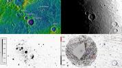
2011-07-07 |
Mercury
|
MESSENGER
|
MDIS - Narrow Angle
MLA
|
503x414x3 |
|
-
PIA14394:
-
Taking the Measure of Impact Craters on Mercury
Full Resolution:
TIFF
(625.6 kB)
JPEG
(40.76 kB)
|
|
|
2011-07-06 |
Earth
|
OSTM/Jason-2
|
Altimeter
|
900x900x3 |
|
-
PIA14383:
-
La Niña's Exit Leaves Climate Forecasts in Limbo
Full Resolution:
TIFF
(2.433 MB)
JPEG
(104.9 kB)
|
|
|
2011-07-06 |
Mars
|
2001 Mars Odyssey
Mars Global Surveyor (MGS)
Mars Science Laboratory (MSL)
|
MOLA
THEMIS
|
1920x1080x3 |
|
-
PIA14291:
-
Oblique view of Gale Crater from the North
Full Resolution:
TIFF
(6.23 MB)
JPEG
(170.8 kB)
|
|
|
2011-06-16 |
Mercury
|
MESSENGER
|
MDIS - Wide Angle
MLA
|
1280x2160x3 |
|
-
PIA14350:
-
A Look at Craters Hosting Polar Deposits
Full Resolution:
TIFF
(8.303 MB)
JPEG
(515.8 kB)
|
|
|
2011-06-16 |
Mercury
|
MESSENGER
|
MLA
|
480x270x3 |
|
-
PIA14345:
-
Movie of MLA Coverage to Date
Full Resolution:
TIFF
(389.5 kB)
JPEG
(12.75 kB)
|
|
|
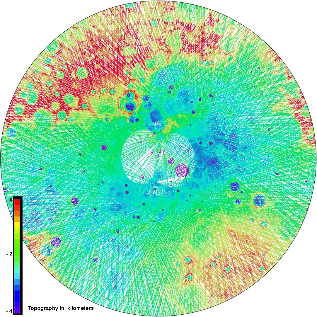
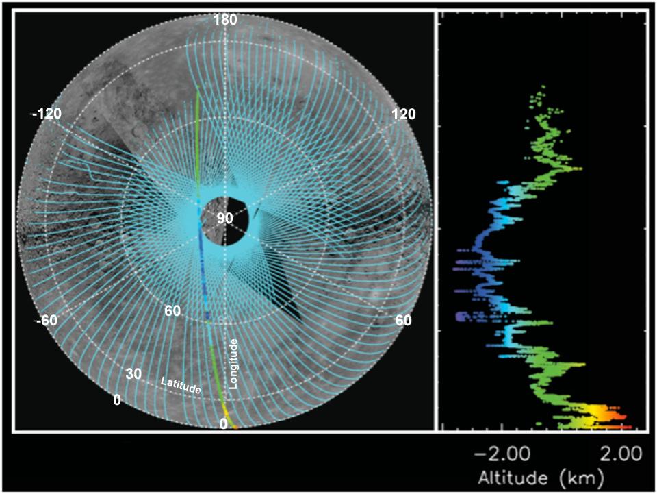
2011-05-24 |
Mercury
|
MESSENGER
|
MLA
|
960x721x3 |
|
-
PIA14279:
-
Altimetry Is Defining Mercury's Shape
Full Resolution:
TIFF
(2.08 MB)
JPEG
(101 kB)
|
|
|
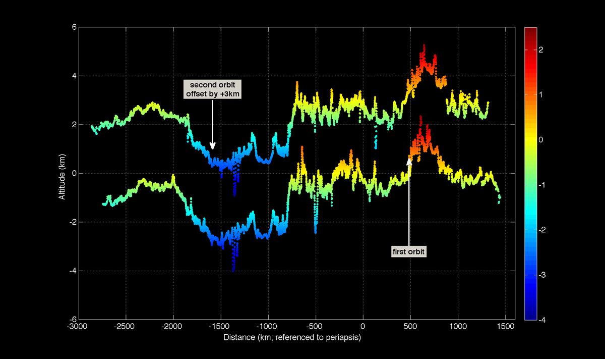
2011-03-30 |
Mercury
|
MESSENGER
|
MLA
|
1200x711x3 |

|
-
PIA14078:
-
First Mercury Laser Altimeter (MLA) Results from Orbit
Full Resolution:
TIFF
(2.563 MB)
JPEG
(83.89 kB)
|
|
|
2011-03-08 |
Mars
|
2001 Mars Odyssey
Mars Global Surveyor (MGS)
|
MOLA
THEMIS
|
708x605x3 |
|
-
PIA13801:
-
Nature's Drilling Exposes Deeply Buried Minerals
Full Resolution:
TIFF
(1.287 MB)
JPEG
(85.93 kB)
|
|
|
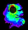
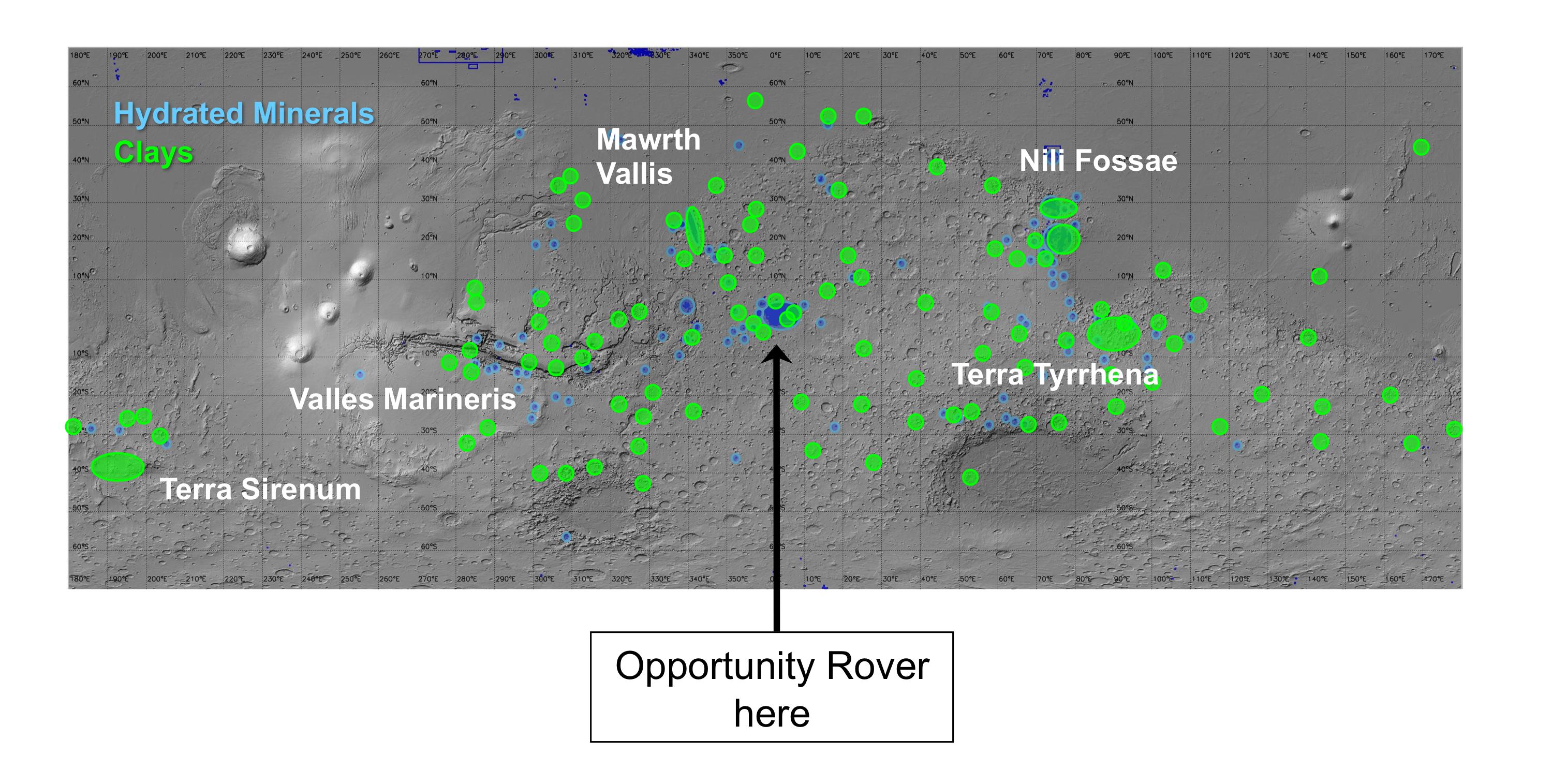
2010-12-16 |
Mars
|
Mars Express (MEX)
Mars Global Surveyor (MGS)
Mars Reconnaissance Orbiter (MRO)
|
Altimeter
CRISM
Visible and Infrared Mineralogical Mapping Spectrometer
|
2999x1515x3 |
|
-
PIA13703:
-
Regions of Mars with Clays and Hydrated Minerals Identified from Orbit
Full Resolution:
TIFF
(13.63 MB)
JPEG
(581.5 kB)
|
|
|
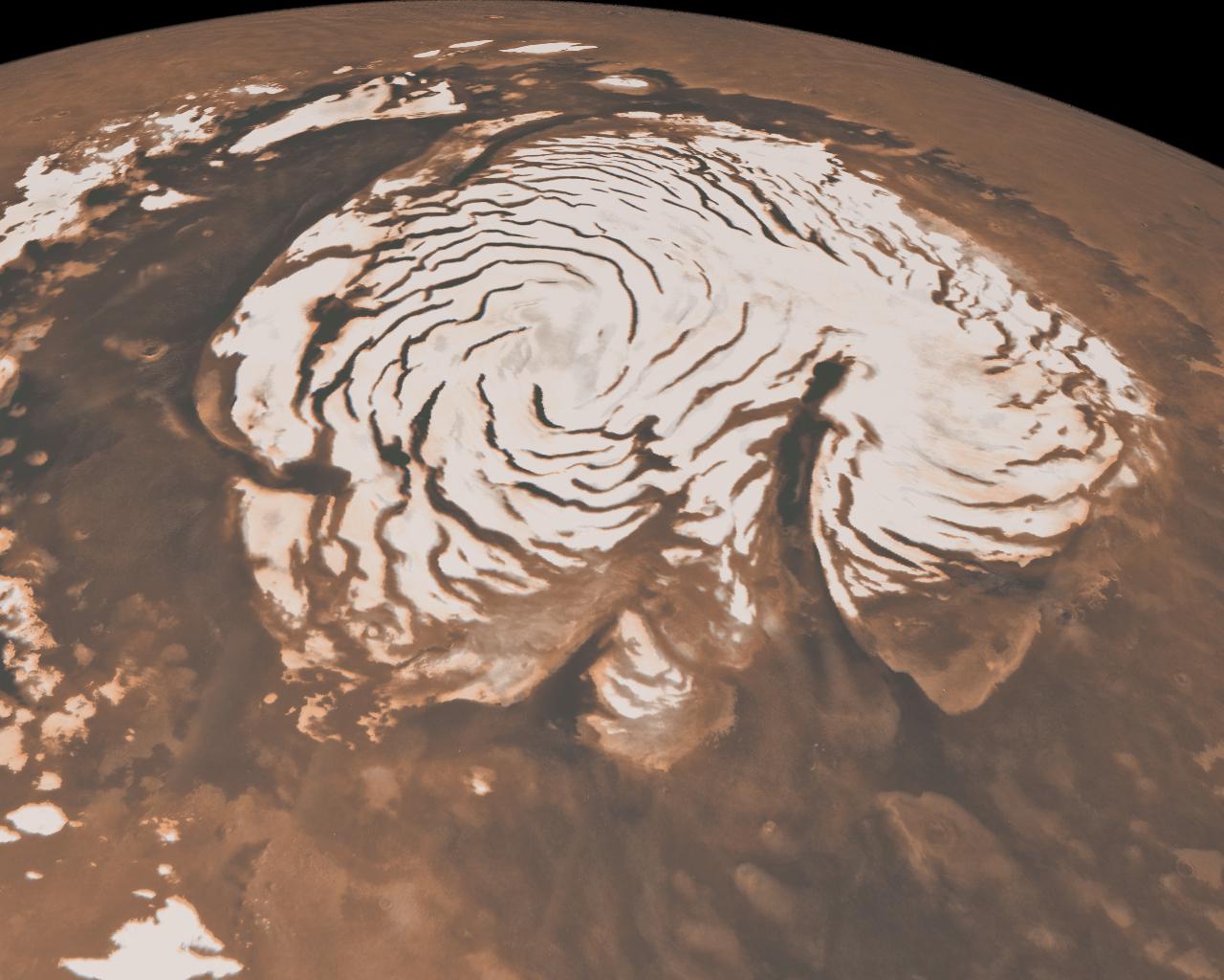
2010-06-24 |
Mars
|
Viking
Mars Global Surveyor (MGS)
|
MOLA
|
984x960x3 |
|
-
PIA13215:
-
Hydrated Minerals Exposed at Lyot, Northern Mars
Full Resolution:
TIFF
(2.838 MB)
JPEG
(153.2 kB)
|
|
|
2010-06-22 |
Earth
|
OSTM/Jason-2
|
Altimeter
|
1304x1268x3 |
|
-
PIA13211:
-
Adios El Niño, Hello La Niña?
Full Resolution:
TIFF
(4.966 MB)
JPEG
(158.7 kB)
|
|
|
2010-05-26 |
Mars
|
Mars Global Surveyor (MGS)
|
Mars Orbiter Camera (MOC)
MOLA
|
1280x1024x3 |
|
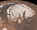
-
PIA13163:
-
Northern Ice Cap of Mars
Full Resolution:
TIFF
(3.936 MB)
JPEG
(141.1 kB)
|
|
|
2010-05-24 |
Earth
|
OSTM/Jason-2
|
Altimeter
|
612x627x3 |

|
-
PIA13155:
-
Birth of a Loop Current Eddy
Full Resolution:
TIFF
(385.9 kB)
JPEG
(69.75 kB)
|
|
|
2010-03-16 |
Earth
|
OSTM/Jason-2
|
Altimeter
|
900x900x3 |
|
-
PIA12962:
-
El Niño's Last Stand?
Full Resolution:
TIFF
(2.433 MB)
JPEG
(108.4 kB)
|
|
|
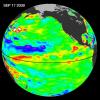
2009-12-17 |
Earth
|
OSTM/Jason-2
|
Altimeter
|
900x900x3 |
|
-
PIA12404:
-
El Niño Surges; Warm Kelvin Wave Headed for South America
Full Resolution:
TIFF
(2.433 MB)
JPEG
(109.1 kB)
|
|
|
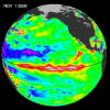
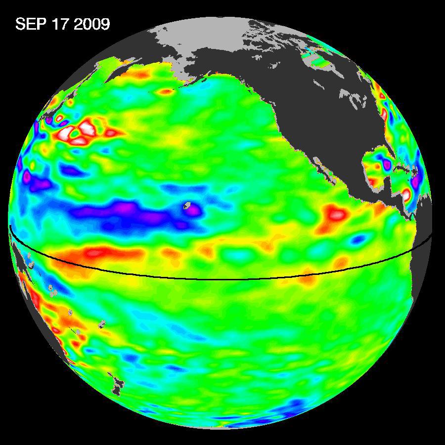
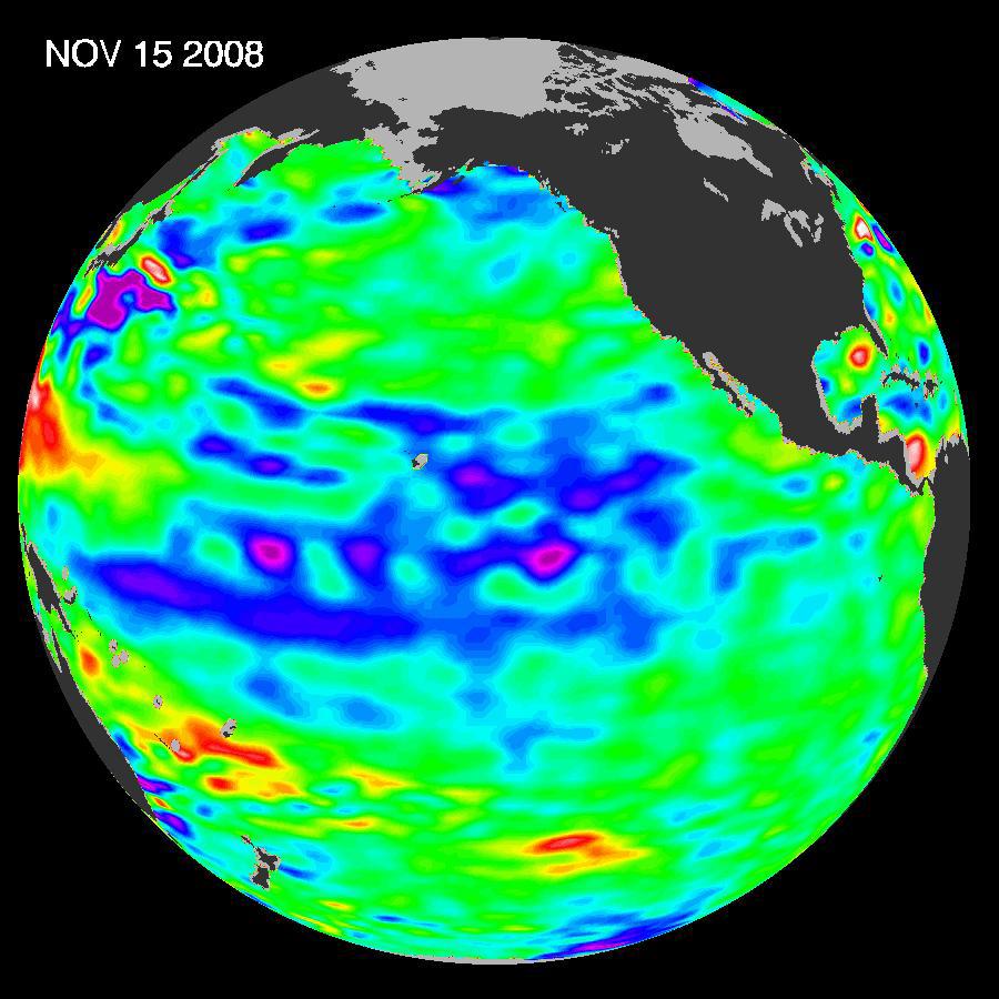
2009-11-12 |
Earth
|
OSTM/Jason-2
|
Altimeter
|
900x900x3 |
|
-
PIA12326:
-
El Niño Pumping Up, Warm Kelvin Wave Surges Toward South America
Full Resolution:
TIFF
(2.433 MB)
JPEG
(106 kB)
|
|
|
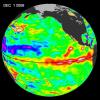
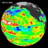
2009-10-29 |
Earth
|
OSTM/Jason-2
|
Altimeter
|
900x900x3 |
|
-
PIA12334:
-
Waves That Feed El Niños
Full Resolution:
TIFF
(2.433 MB)
JPEG
(104.4 kB)
|
|
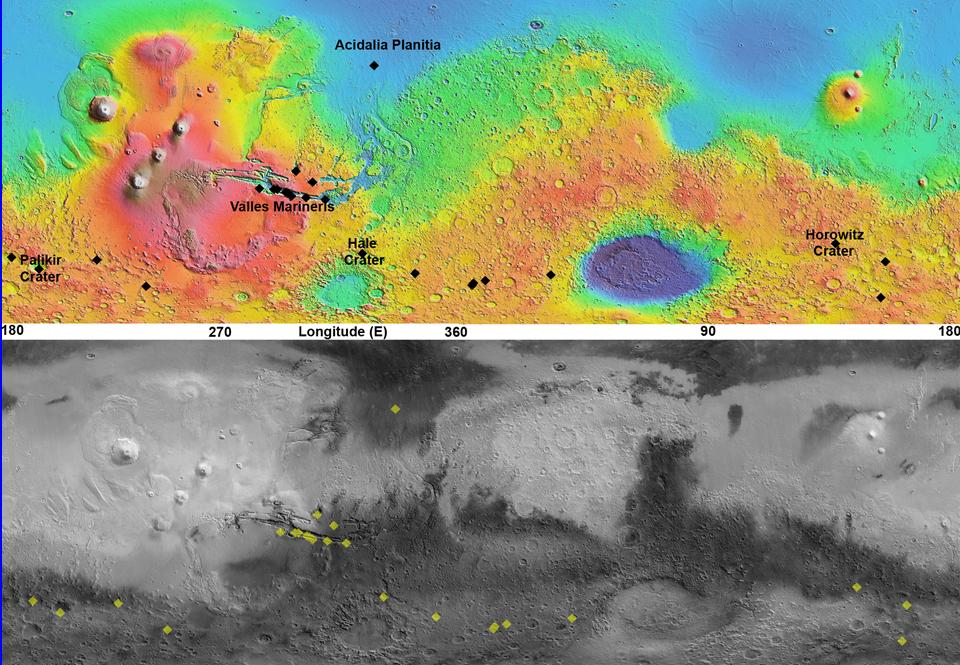
|
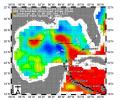
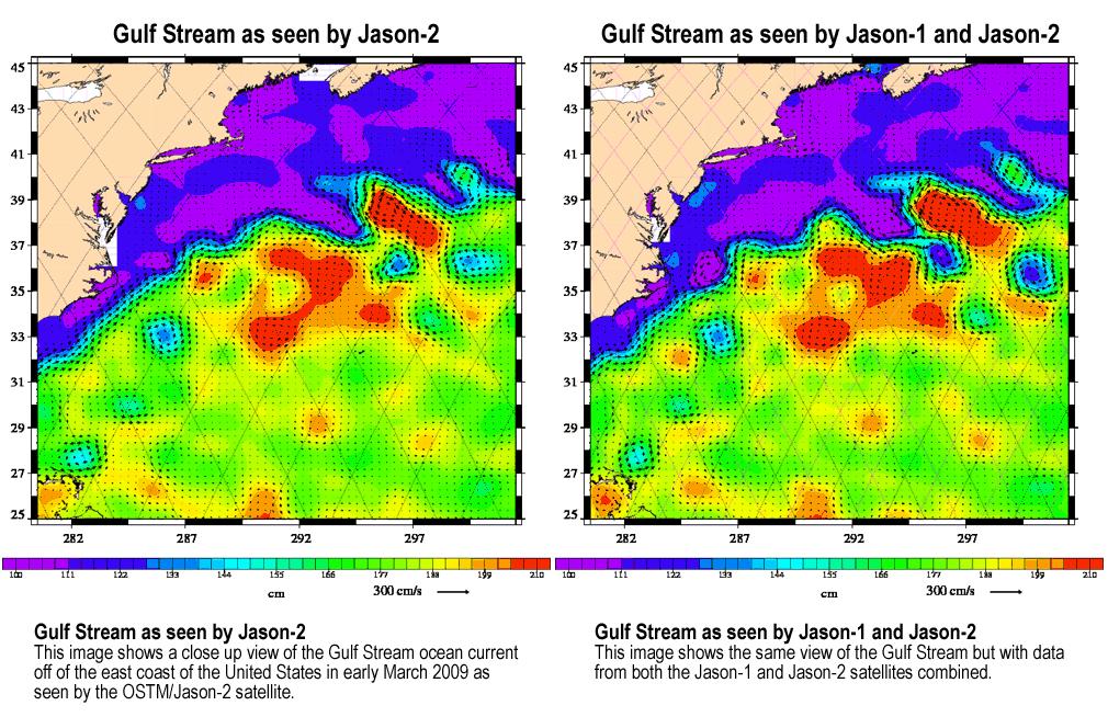
2009-04-27 |
Earth
|
Jason-1
OSTM/Jason-2
|
Altimeter
|
1010x654x3 |
|
-
PIA11997:
-
OSTM/Jason-2 and Jason-1 Tandem Mission View of the Gulf Stream
Full Resolution:
TIFF
(663 kB)
JPEG
(187.6 kB)
|
|
|
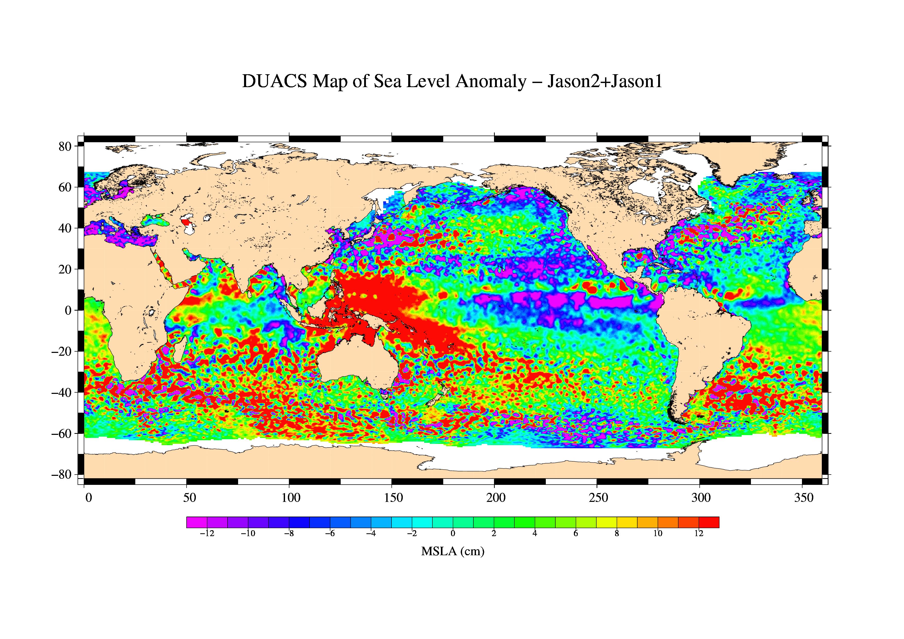
2009-03-26 |
Earth
|
Jason-1
OSTM/Jason-2
|
Altimeter
|
3508x2479x3 |

|
-
PIA11859:
-
First Jason-1 and OSTM/Jason-2 Tandem Global View
Full Resolution:
TIFF
(26.09 MB)
JPEG
(1.128 MB)
|
|
|
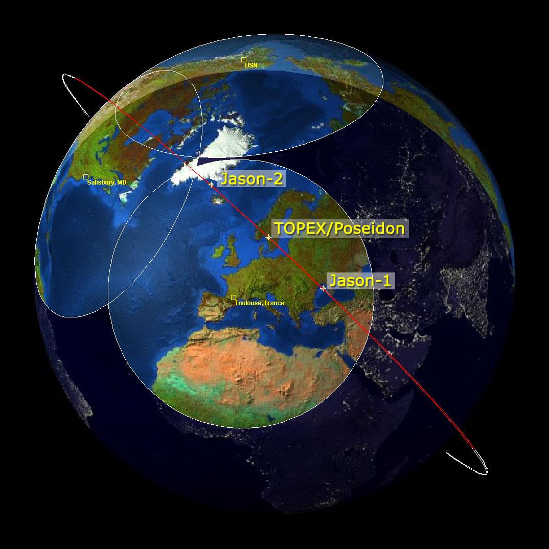
2009-02-06 |
Earth
|
Jason-1
OSTM/Jason-2
|
Altimeter
|
1074x1074x3 |

|
-
PIA11794:
-
Altimeter Family Portrait: Topex/Poseidon, Jason-1 and OSTM/Jason-2
Full Resolution:
TIFF
(3.465 MB)
JPEG
(131 kB)
|
|
|
2008-12-13 |
Earth
|
Jason-1
|
Altimeter
|
900x900x3 |
|
-
PIA11710:
-
Oscillation Rules as the Pacific Cools
Full Resolution:
TIFF
(2.433 MB)
JPEG
(102.9 kB)
|
|
|
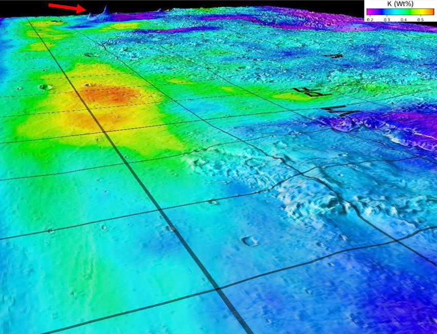
2008-11-18 |
Mars
|
2001 Mars Odyssey
|
Gamma Ray Spectrometer
Laser Altimeter
|
850x650x3 |
|
-
PIA11421:
-
Potassium Concentrations on Mars
Full Resolution:
TIFF
(1.659 MB)
JPEG
(122.3 kB)
|
|
|
2008-10-31 |
Mercury
|
MESSENGER
|
MDIS - Narrow Angle
MLA
|
719x523x3 |
|
-
PIA11414:
-
Mercury Laser Altimeter (MLA) Measures the Depths of Mercury's Craters
Full Resolution:
TIFF
(1.13 MB)
JPEG
(65.5 kB)
|
|
|
2008-10-29 |
Mercury
|
MESSENGER
|
MDIS - Narrow Angle
MLA
|
612x384x3 |
|
-
PIA11405:
-
Mercury's Topography from the Second Flyby
Full Resolution:
TIFF
(706 kB)
JPEG
(39.97 kB)
|
|
|
2008-09-24 |
Earth
|
OSTM/Jason-2
|
Altimeter
|
1225x710x3 |
|
-
PIA11197:
-
Newest Ocean-Observing Satellite Records Recent Sea Level Changes
Full Resolution:
TIFF
(872.5 kB)
JPEG
(211.1 kB)
|
|
|
2008-08-04 |
Mars
|
Mars Global Surveyor (MGS)
Phoenix
|
MOLA
|
640x360x3 |
|
-
PIA11029:
-
Wind-Related Topography in Phoenix's Region of Mars (Animation)
Full Resolution:
TIFF
(692.2 kB)
JPEG
(12.34 kB)
|
|
|
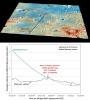
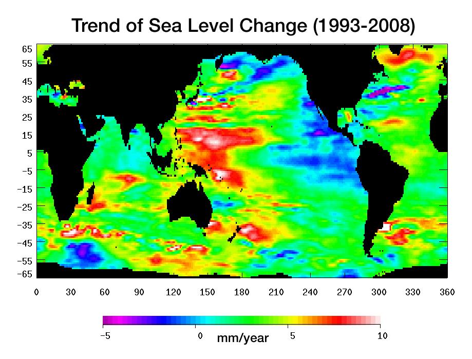
2008-07-31 |
Earth
|
Jason-1
|
Altimeter
|
919x699x3 |
|
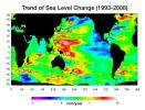
-
PIA11002:
-
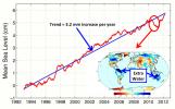
Portrait of a Warming Ocean and Rising Sea Levels:
Trend of Sea Level Change 1993-2008
Full Resolution:
TIFF
(644.9 kB)
JPEG
(104.2 kB)
|
|
|
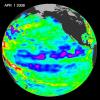
2008-05-26 |
Mars
|
Phoenix
|
MOLA
Surface Stereo Imager (SSI)
|
640x360x3 |

|
-
PIA10694:
-
Phoenix's Position on Mars
Full Resolution:
TIFF
(692.2 kB)
JPEG
(12.07 kB)
|
|
|
2008-05-22 |
Mars
|
Mars Global Surveyor (MGS)
Phoenix
|
MOLA
|
720x486x3 |

|
-
PIA10656:
-
Six Landing Sites on Mars
Full Resolution:
TIFF
(1.051 MB)
JPEG
(44.63 kB)
|
|
|
2008-04-22 |
Earth
|
Jason-1
|
Altimeter
|
900x900x3 |
|
-
PIA10377:
-
Larger Pacific Climate Event Helps Current La Niña Linger
Full Resolution:
TIFF
(2.433 MB)
JPEG
(103 kB)
|
|
|
2008-03-31 |
Mercury
|
MESSENGER
|
MLA
|
1164x996x3 |
|
-
PIA10608:
-
Mercury Laser Altimeter (MLA) Images Mercury from 4 Million Kilometers
Full Resolution:
TIFF
(3.482 MB)
JPEG
(144.3 kB)
|
|
|
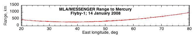
2008-01-30 |
Mercury
|
MESSENGER
|
MLA
|
3000x2025x3 |
|
-
PIA10394:
-
First Laser Altimetry for Mercury
Full Resolution:
TIFF
(18.23 MB)
JPEG
(557.2 kB)
|
|
|
2008-01-30 |
Mercury
|
MESSENGER
|
MLA
|
3000x2025x3 |
|
-
PIA10381:
-
Topographic Close-up
Full Resolution:
TIFF
(18.23 MB)
JPEG
(357.3 kB)
|
|
|
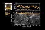
2008-01-19 |
Mercury
|
MESSENGER
|
MLA
|
666x126x3 |

|
-
PIA10183:
First Results from the Mercury Laser Altimeter
Full Resolution:
TIFF
(252.2 kB)
JPEG
(16.75 kB)
|
|
|
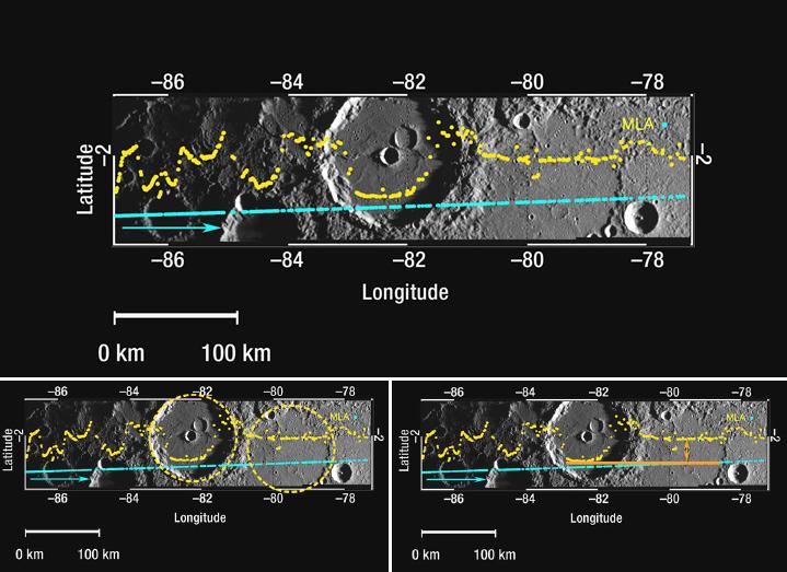
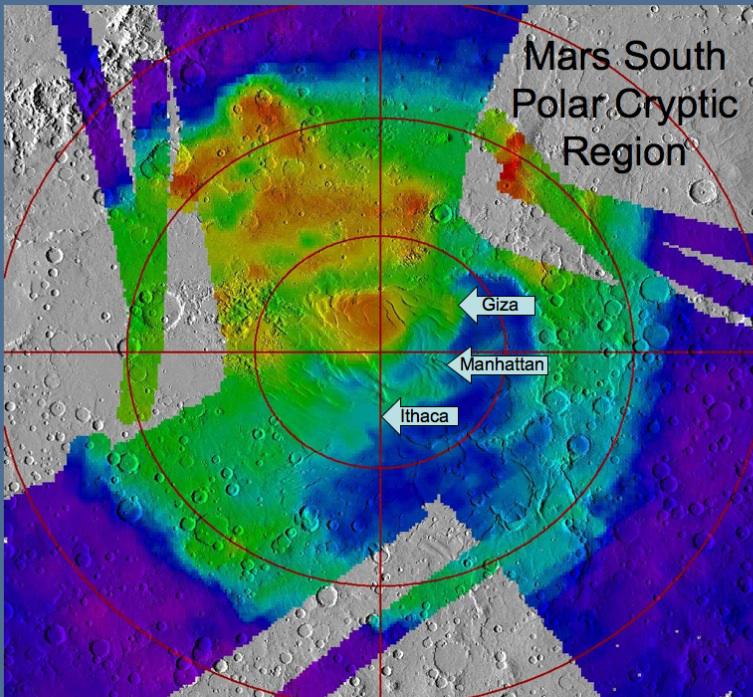
2007-12-11 |
Mars
|
Mars Global Surveyor (MGS)
|
MOLA
Thermal Emission Spectrometer
|
753x697x3 |
|
-
PIA10138:
-
Location of Sites Within 'Cryptic Terrain'
Full Resolution:
TIFF
(1.577 MB)
JPEG
(111.7 kB)
|
|
|
2007-12-11 |
Mars
|
Mars Global Surveyor (MGS)
|
MOLA
|
2502x1320x1 |
|
-
PIA10132:
-
Global View of Mars Topography
Full Resolution:
TIFF
(3.306 MB)
JPEG
(791.3 kB)
|
|
|
2007-11-07 |
Earth
|
Jason-1
|
Altimeter
|
900x900x3 |
|
-
PIA10110:
-
La Niña Persists
Full Resolution:
TIFF
(2.433 MB)
JPEG
(103.4 kB)
|
|
|
2007-08-02 |
Mars
|
Mars Global Surveyor (MGS)
Phoenix
|
MOLA
|
1019x985x3 |
|
-
PIA09945:
-
Topographical Context of Phoenix Landing Region
Full Resolution:
TIFF
(3.015 MB)
JPEG
(137 kB)
|
|
|
2007-08-02 |
Mars
|
Mars Global Surveyor (MGS)
Phoenix
|
MOLA
|
1127x1125x3 |
|
-
PIA09944:
-
Far-Northern Destination for Phoenix Mars Lander
Full Resolution:
TIFF
(3.808 MB)
JPEG
(244.1 kB)
|
|
|
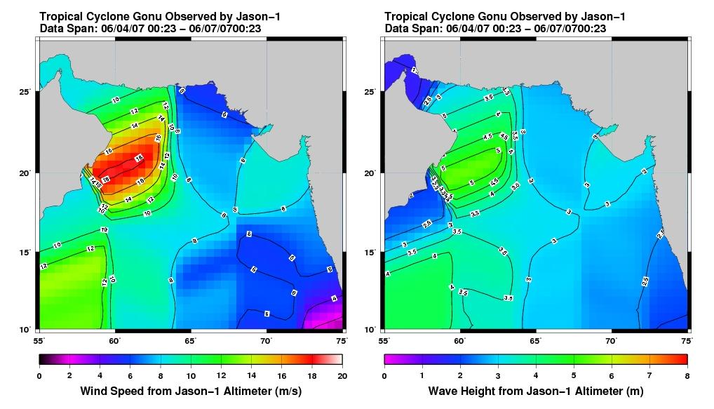
2007-06-08 |
Earth
|
Jason-1
|
Altimeter
|
1018x583x3 |
|
-
PIA09602:
-
Jason Tracks Powerful Tropical Cyclone Gonu's High Winds, Waves
Full Resolution:
TIFF
(1.783 MB)
JPEG
(92.12 kB)
|
|
|
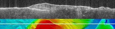
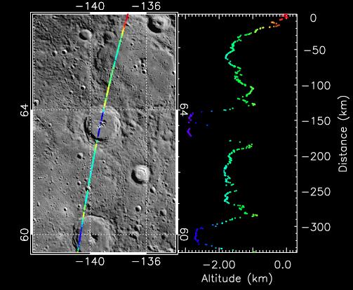
2007-03-15 |
Mars
|
Mars Express (MEX)
Mars Global Surveyor (MGS)
|
MARSIS
Mars Orbiter Laser Altimeter
|
2369x2558x3 |
|
-
PIA09226:
-
Upper Surface of Icy Layers Covering Mars' South Polar Region
Full Resolution:
TIFF
(18.2 MB)
JPEG
(1.033 MB)
|
|
|
2007-03-15 |
Mars
|
Mars Express (MEX)
Mars Global Surveyor (MGS)
|
MARSIS
Mars Orbiter Laser Altimeter
|
2369x2558x3 |
|
-
PIA09225:
-
Lower Boundary of Icy Layers Covering Mars' South Polar Region
Full Resolution:
TIFF
(18.2 MB)
JPEG
(938.3 kB)
|
|
|
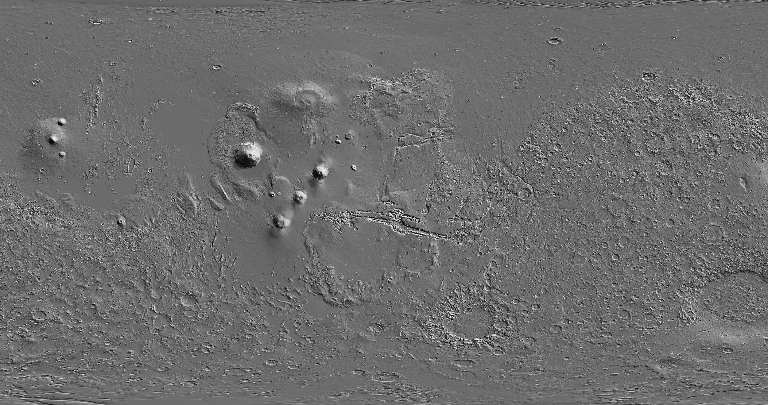
2007-03-15 |
Mars
|
Mars Express (MEX)
Mars Global Surveyor (MGS)
|
MARSIS
Mars Orbiter Laser Altimeter
|
2369x2558x3 |
|
-
PIA09224:
-
Thickness of Mars' South Polar Layered Deposits
Full Resolution:
TIFF
(18.2 MB)
JPEG
(462.9 kB)
|
|
|
2007-03-15 |
Mars
|
Mars Express (MEX)
Mars Global Surveyor (MGS)
|
MARSIS
Mars Orbiter Laser Altimeter
|
2251x457x3 |

|
-
PIA09223:
Virtual Slice Through Icy Layered Deposits Near Mars' South Pole
Full Resolution:
TIFF
(3.09 MB)
JPEG
(149.5 kB)
|
|
|
2007-03-15 |
Mars
|
Mars Express (MEX)
Mars Global Surveyor (MGS)
|
MARSIS
Mars Orbiter Laser Altimeter
|
1784x460x3 |
|
-
PIA09222:
Bright Lower Echo in Radargram of South Polar Layered Deposits
Full Resolution:
TIFF
(2.466 MB)
JPEG
(124.4 kB)
|
|
|
2007-03-02 |
Earth
|
Jason-1
|
Altimeter
|
900x900x3 |

|
-
PIA09208:
-
Pacific Shows Signs of Morphing From Warm El Nino To Cool La Nina
Full Resolution:
TIFF
(2.433 MB)
JPEG
(100.2 kB)
|
|
|
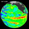
2006-12-07 |
Earth
|
Jason-1
|
Altimeter
|
900x900x3 |
|
-
PIA09038:
-
Jason Celebrates 5th Anniversary as El Niño Builds, Warm Kelvin Wave Surges Toward South America
Full Resolution:
TIFF
(2.433 MB)
JPEG
(105.2 kB)
|
|
|
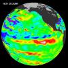
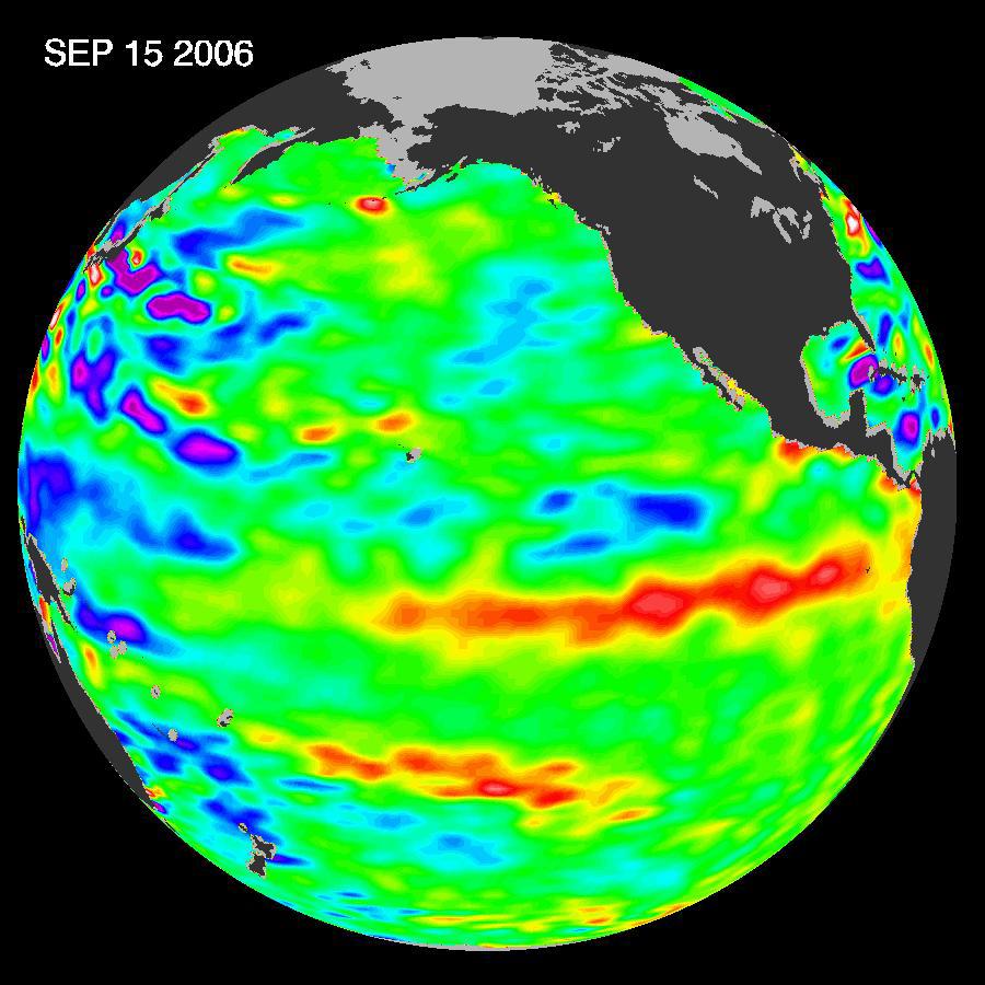
2006-10-10 |
Earth
|
Jason-1
|
Altimeter
|
900x900x3 |
|
-
PIA01939:
-
Jason Satellite Observes Mild El Nino in 2006
Full Resolution:
TIFF
(2.433 MB)
JPEG
(103 kB)
|
|
|
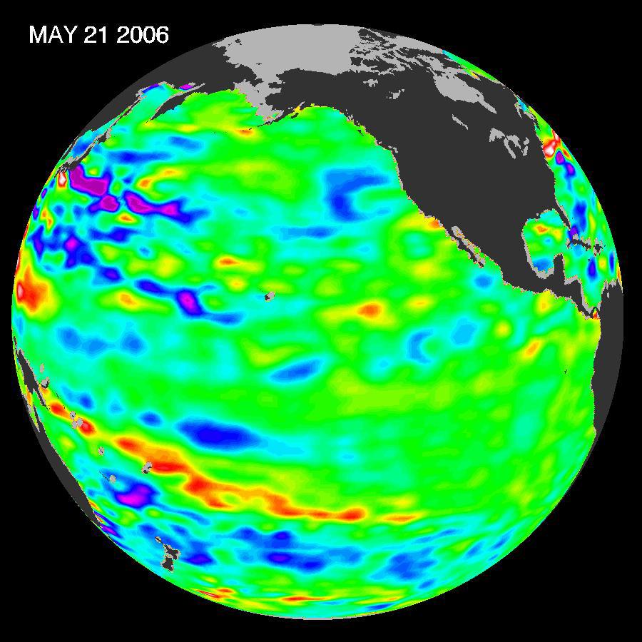
2006-05-30 |
Earth
|
Jason-1
|
Altimeter
|
900x900x3 |
|
-
PIA08501:
-
Pacific Climate Calm
Full Resolution:
TIFF
(2.433 MB)
JPEG
(101.5 kB)
|
|
|
2006-01-13 |
Earth
|
Jason-1
|
Altimeter
|
900x900x3 |
|
-
PIA03665:
-
She's Back? La Niña Developing?
Full Resolution:
TIFF
(2.433 MB)
JPEG
(116.8 kB)
|
|
|
2005-11-30 |
Mars
|
Mars Express (MEX)
Mars Global Surveyor (MGS)
|
Mars Advanced Radar for Subsurface and Ionospheric Sounding
(MARSIS)
Mars Orbiter Laser Altimeter
|
788x683x3 |
|
-
PIA03237:
-
Topographic Map of Chryse Planitia with Location of Possible Buried Basin
Full Resolution:
TIFF
(1.617 MB)
JPEG
(106.2 kB)
|
|
|
2005-11-30 |
Mars
|
Mars Express (MEX)
Mars Global Surveyor (MGS)
|
MARSIS
Mars Orbiter Laser Altimeter
|
979x666x3 |

|
-
PIA03235:
-
Radargram of Mars' North Polar Layered Deposits with Topographic Map
Full Resolution:
TIFF
(1.959 MB)
JPEG
(95.14 kB)
|
|
|
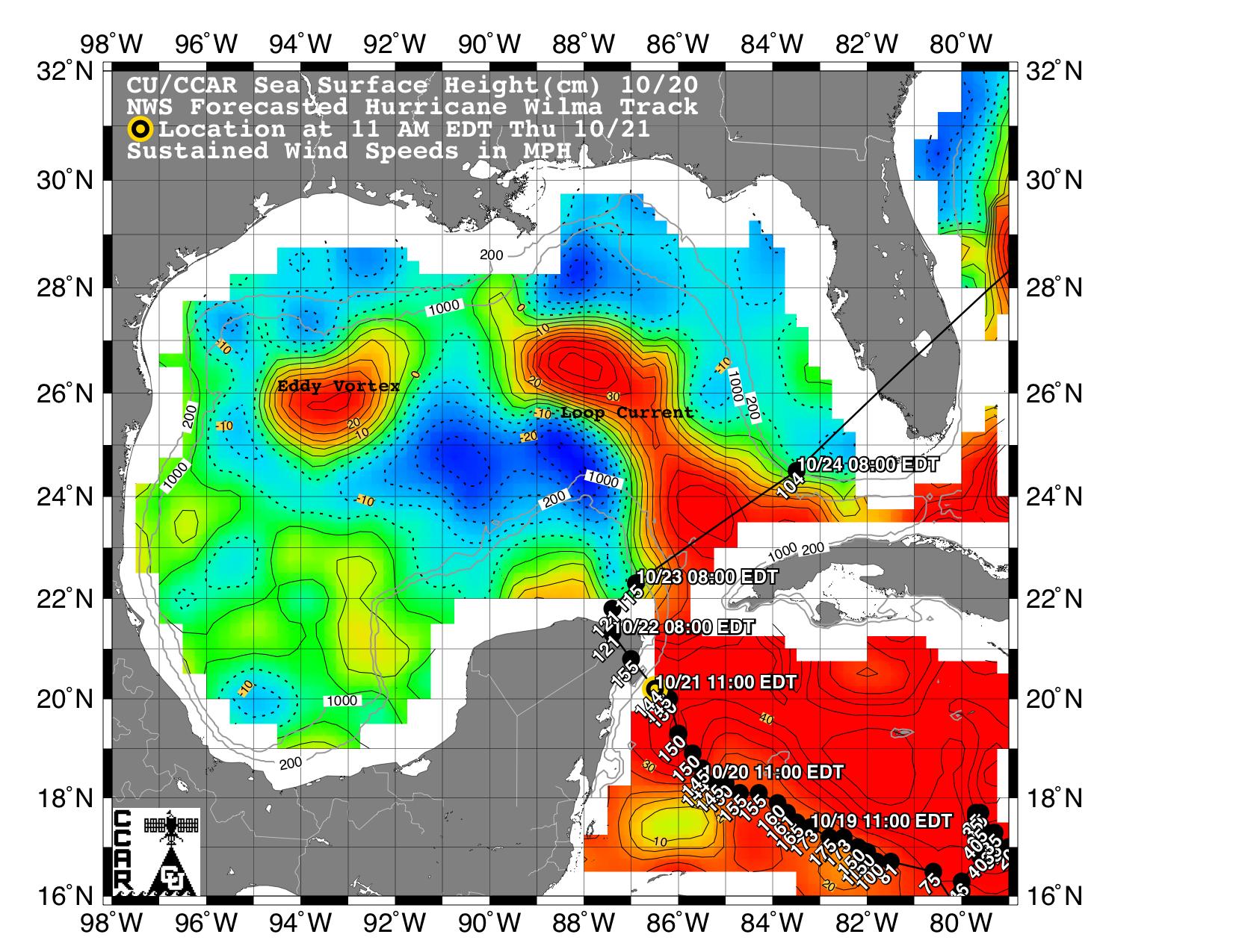
2005-10-21 |
Earth
|
Jason-1
|
Altimeter
|
1650x1275x3 |
|
-
PIA03055:
-
Wilma's Trek Through Warm Caribbean/Gulf Waters
Full Resolution:
TIFF
(6.322 MB)
JPEG
(373.6 kB)
|
 Planetary Data System


