PDS logoPlanetary Data System
PDS Information
Find a Node - Use these links to navigate to any of the 8 publicly accessible PDS Nodes.

This bar indicates that you are within the PDS enterprise which includes 6 science discipline nodes and 2 support nodes which are overseen by the Project Management Office at NASA's Goddard Space Flight Center (GSFC). Each node is led by an expert in the subject discipline, supported by an advisory group of other practitioners of that discipline, and subject to selection and approval under a regular NASA Research Announcement.
Click here to return to the Photojournal Home Page Click here to view a list of Photojournal Image Galleries Photojournal_inner_header
Latest Images  |  Spacecraft & Technology  |  Animations  |  Space Images App  |  Feedback  |  Photojournal Search  

PIA09945: Topographical Context of Phoenix Landing Region
 Target Name:  Mars
 Is a satellite of:  Sol (our sun)
 Mission:  Mars Global Surveyor (MGS)
Phoenix
 Spacecraft:  Mars Global Surveyor Orbiter
 Instrument:  MOLA
 Product Size:  1019 x 985 pixels (w x h)
 Produced By:  University of Arizona
 Full-Res TIFF:  PIA09945.tif (3.015 MB)
 Full-Res JPEG:  PIA09945.jpg (137 kB)

Click on the image above to download a moderately sized image in JPEG format (possibly reduced in size from original)

Original Caption Released with Image:

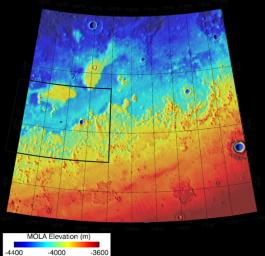
Color coding indicates the topography in this map of the region of Mars from 65 to 72 degrees north latitude and from 230 to 250 degrees east longitude. This area was designated "Region D" in the process of evaluating potential landing sites for NASA's Phoenix Mars Lander. The location chosen for safe landing sites is within the box bordered with a heavy black line along the western boundary of this region.

Elevation in the region varies from about 3,600 meters (11,800 feet) to 4,400 meters (14,400 feet) below the zero reference point for Martian surface elevation. The topographical information is from the Mars Orbiter Laser Altimeter on NASA's Mars Global Surveyor orbiter.

Photojournal Note: As planned, the Phoenix lander, which landed May 25, 2008 23:53 UTC, ended communications in November 2008, about six months after landing, when its solar panels ceased operating in the dark Martian winter.

Image Credit:
NASA/JPL-Caltech/Washington Univ. St. Louis/Univ. of Arizona

Image Addition Date:
2007-08-02