
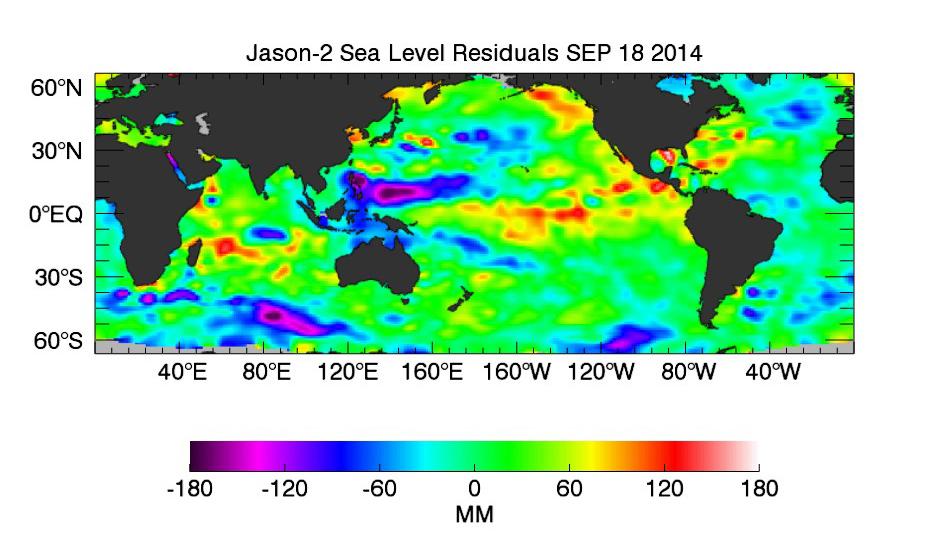
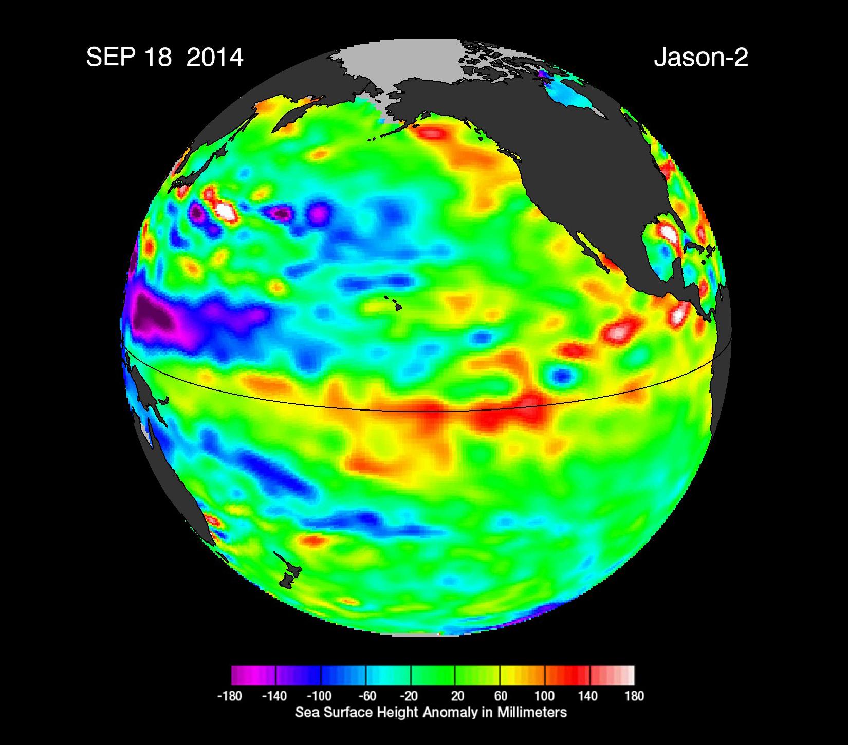
Jason-2 Sea Level Residuals Sept. 18, 2014
Click on the image for larger versionThe latest sea-level-height data from the NASA/European Ocean Surface Topography Mission (OSTM)/Jason-2 satellite mission show a pair of eastward-moving waves of higher sea level, known as Kelvin waves, in the Pacific Ocean -- the third such pair of waves this year. Now crossing the central and eastern equatorial Pacific, these warm waves appear as the large area of higher-than-normal sea surface heights (warmer-than-normal ocean temperatures) hugging the equator between 120 degrees west and the International Dateline. The Kelvin waves are traveling eastward and should arrive off Ecuador in late September and early October.
This image was created with data collected by the U.S./European OSTM/Jason-2 satellite during a 10-day period centered on Sept. 18, 2014. It shows a red and yellow area in the central and eastern equatorial Pacific, indicating that the ocean surface is about 4 to 6 inches (10 to 12 centimeters) above normal. Green indicates near-normal conditions. These regions contrast with the western equatorial Pacific, where sea levels (blue and purple areas) are 3 to 6 inches (8 to 15 centimeters) lower than normal.
The height of the ocean water relates, in part, to its temperature, and thus is an indicator of the amount of heat stored in the ocean below. As the ocean warms, the water expands and the sea level rises; as it cools, its level falls. Above-normal height variations along the equatorial Pacific indicate El Niño conditions, while below-normal height variations indicate La Niña conditions. The temperature of the upper ocean can have a significant influence on weather patterns and climate.
For an overview of 2014's El Niño prospects and Kelvin waves, please see http://science.nasa.gov/science-news/science-at-nasa/2014/19may_elnino/.
To learn more on NASA's satellite altimetry programs, visit http://sealevel.jpl.nasa.gov.
The comings and goings of El Niño and La Niña are part of the long-term, evolving state of global climate, for which measurements of sea surface height are a key indicator. Jason-2 is a joint effort between NASA, the National Oceanic and Atmospheric Administration (NOAA), the French Space Agency Centre National d'Etudes Spatiales (CNES) and the European Organisation for the Exploitation of Meteorological Satellites (EUMETSAT). JPL manages the U.S. portion of Jason-2 for NASA's Science Mission Directorate, Washington, D.C. In early 2015, NASA and its international partners CNES, NOAA and EUMETSAT will launch Jason-3, which will extend the timeline of ocean surface topography measurements begun by the Topex/Poseidon and Jason 1 and 2 satellites. Jason-3 will make highly detailed measurements of sea level on Earth to gain insight into ocean circulation and climate change. JPL is a division of the California Institute of Technology.
Photojournal Note: The Jason-3 launch date is Sunday, Jan. 17, 2016, 10:42 A.M. PST.
 Planetary Data System


