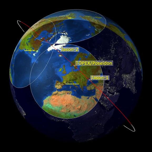
This image is a "family portrait" of Topex/Poseidon, Jason-1 and Ocean Surface Topography Mission/Jason-2 (OSTM/Jason-2), NASA satellites that have measured global sea surface heights since 1992.
The image shows the position of the three satellites as they descend to the southeast, passing over the satellite ground station just outside of Toulouse, France, on January 28, 2009, at 23:39 UTC. As a result of maneuvers performed on January 26 and 27, Jason-1 has drifted well ahead of OSTM/Jason-2 and Topex/Poseidon. It is on its way to a new operational orbit on the other side of the Earth, 162 degrees ahead of OSTM/Jason-2.
Once in its new position, Jason-1 will continue making sea surface height measurements in tandem with OSTM/Jason-2. During this tandem mission, Jason-1 will fly over the same region of the ocean that OSTM/Jason-2 flew over five days earlier. Working together, the two spacecraft will measure the surface topography of the ocean twice as often as would be possible with one satellite.
The circles on the image represent the ranges of the different ground stations that continuously track the three satellites.
Launched in 1992, Topex/Poseidon was a joint venture between CNES, the French space agency, and NASA to map ocean surface topography. Among its many achievements, Topex/Poseidon measured sea levels with unprecedented accuracy to better than 5 centimeters (2 inches), mapped year-to-year changes in heat stored in the upper ocean, and produced the most accurate global maps of tides ever. The mission ended in 2006.
Jason-1, the follow-on mission to Topex/Poseidon, completed its seventh year on orbit on December 7, 2008. From its vantage point 1,330 kilometers (860 miles) above Earth, Jason-1 has provided measurements of the surface height of the world's oceans to an accuracy of 3.3 centimeters (1.3 inches).
OSTM/Jason-2 is continuing the sea surface height measurements begun by Topex/Poseidon and Jason-1. It launched June 20, 2008, from Vandenberg Air Force Base in California.
More information about NASA's Ocean Surface Topography from Space is available at http://sealevel.jpl.nasa.gov/mission/ostm.html.