The Ocean Surface Topography Mission (OSTM)/Jason-2, launched on June 20, 2008, wasted no time getting to work. The satellite's radar altimeter collected its first data a little more than 48 hours after launch. Within a month, it had already produced its first complete maps of global ocean surface topography, surface wave height and wind speed.
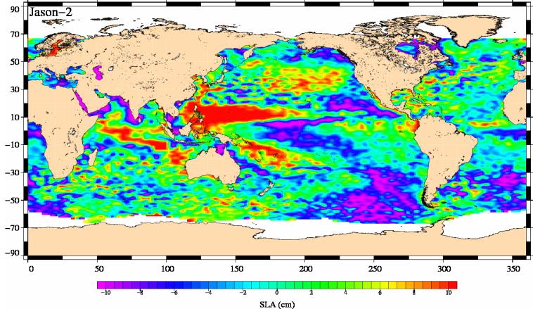
This image shows mean sea-level anomaly data from OSTM/Jason-2 for the period July 21, 2008, to July 31, 2008. An anomaly is a departure from an average value.
Red and yellow are regions where sea levels are higher than normal. Purple and dark blue show where sea levels are lower. A higher-than-normal sea surface is usually a sign of warm waters below, while low sea levels often indicate cooler than normal temperatures.
OSTM/Jason 2 is an international endeavor with responsibility for satellite development and launch shared between NASA and CNES, the French space agency. CNES and the U.S. National Oceanic and Atmospheric Administration (NOAA) are responsible for satellite operations, while JPL is managing the mission for NASA. Data processing is being carried out by CNES, the European Organisation for the Exploitation of Meteorological Satellites (EUMETSAT) and NOAA.
OSTM/Jason-2 is the third altimeter mission on which NASA and CNES have collaborated. The first, Topex/Poseidon, launched in 1992 and was decommissioned in 2006. It was followed by Jason-1, which launched in 2001 and is still in operation.
The continuous data record from these three missions helps scientists monitor how global sea level and the distribution of heat in the ocean changes over time. This information is used to monitor climate change and ocean circulation and benefits society by enabling more accurate weather, ocean and climate forecasts. Plans for Jason-3 are underway with NASA, CNES, EUMETSAT, and NOAA as lead agency.
For more information about OSTM/Jason 2, visit: http://www.nasa.gov/ostm and http://sealevel.jpl.nasa.gov/mission/ostm.html.
Photojournal Note: The Jason-3 launch date is Sunday, Jan. 17, 2016, 10:42 A.M. PST.