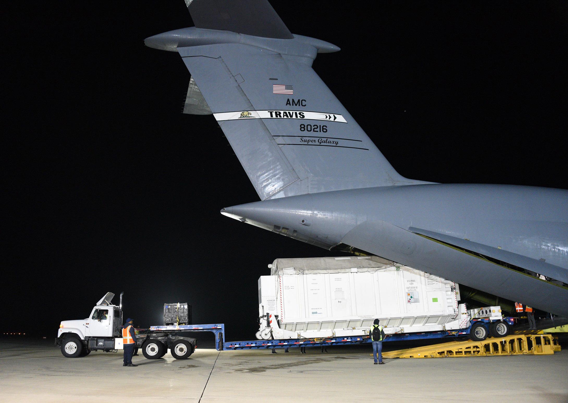
My
List |
Addition Date
|
Target
|
Mission
|
Instrument
|
Size
|

|
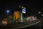
2022-11-14 |
|
Surface Water and Ocean Topography (SWOT)
|
|
8256x5504x3 |
|
-
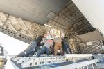
PIA25625:
-
SWOT Headed to France on C-17 Aircraft
Full Resolution:
TIFF
(105.8 MB)
JPEG
(5.21 MB)
|
|
|
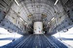
2022-11-14 |
|
Surface Water and Ocean Topography (SWOT)
|
|
8256x5504x3 |
|
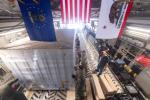
-
PIA25624:
-
SWOT Secured for Transport in C-17 Aircraft
Full Resolution:
TIFF
(120.2 MB)
JPEG
(6.204 MB)
|
|
|
2022-11-14 |
|
Surface Water and Ocean Topography (SWOT)
|
KaRIn
|
8889x5000x3 |
|
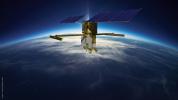
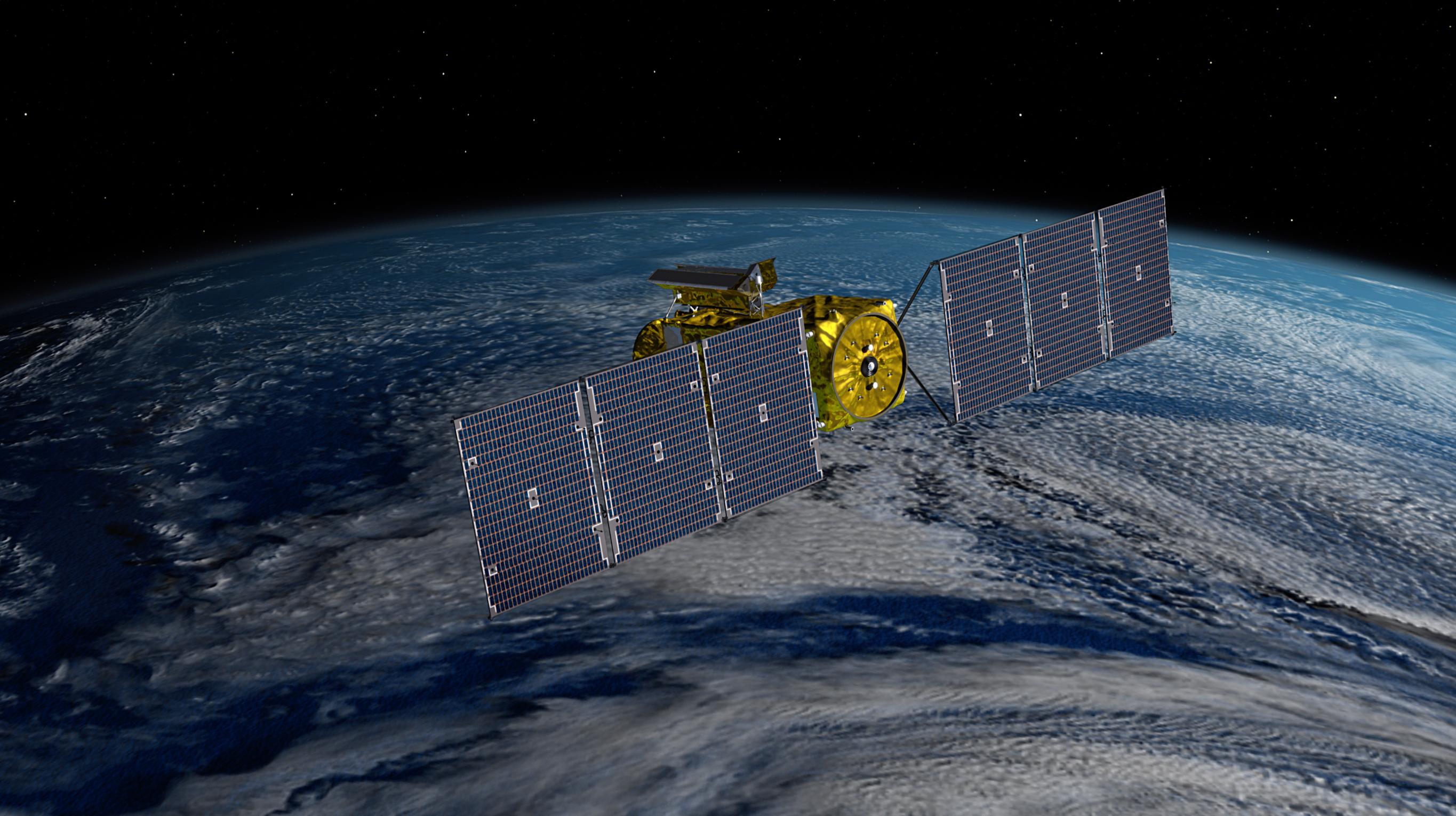
-
PIA25623:
-
SWOT Orbiting Earth (Illustration)
Full Resolution:
TIFF
(77.29 MB)
JPEG
(1.991 MB)
|
|
|
2022-11-14 |
|
Surface Water and Ocean Topography (SWOT)
|
|
2730x1530x3 |

|
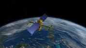
-
PIA25622:
-
SWOT Satellite With Solar Arrays in Full View (Illustration)
Full Resolution:
TIFF
(10.28 MB)
JPEG
(431.7 kB)
|
|
|
2022-11-14 |
|
Surface Water and Ocean Topography (SWOT)
|
KaRIn
|
2560x1440x3 |
|
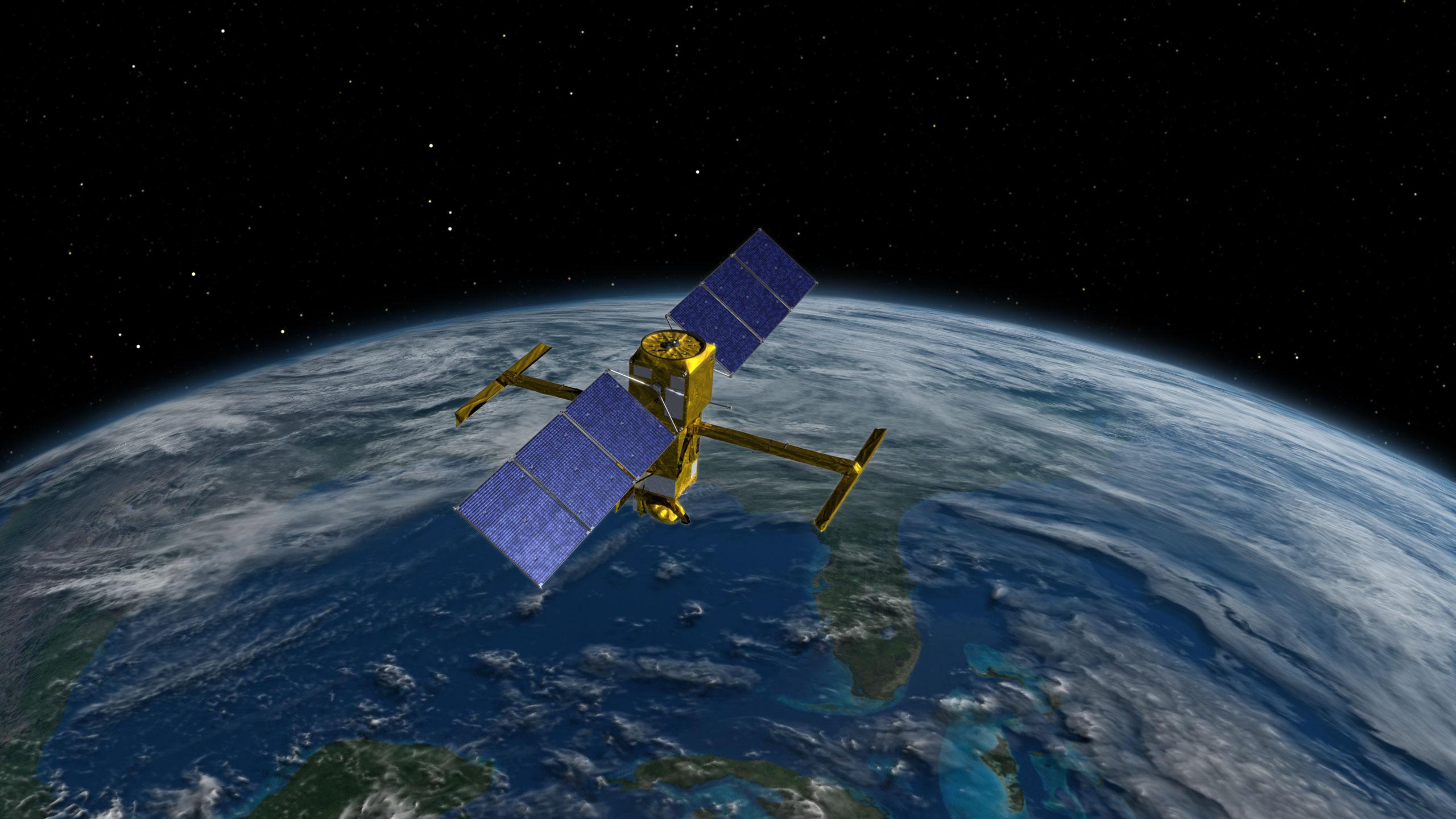
-
PIA25621:
-
SWOT Above Earth (Illustration)
Full Resolution:
TIFF
(6.479 MB)
JPEG
(308.8 kB)
|
|
|
2022-11-14 |
|
Surface Water and Ocean Topography (SWOT)
|
KaRIn
|
2946x1646x3 |

|
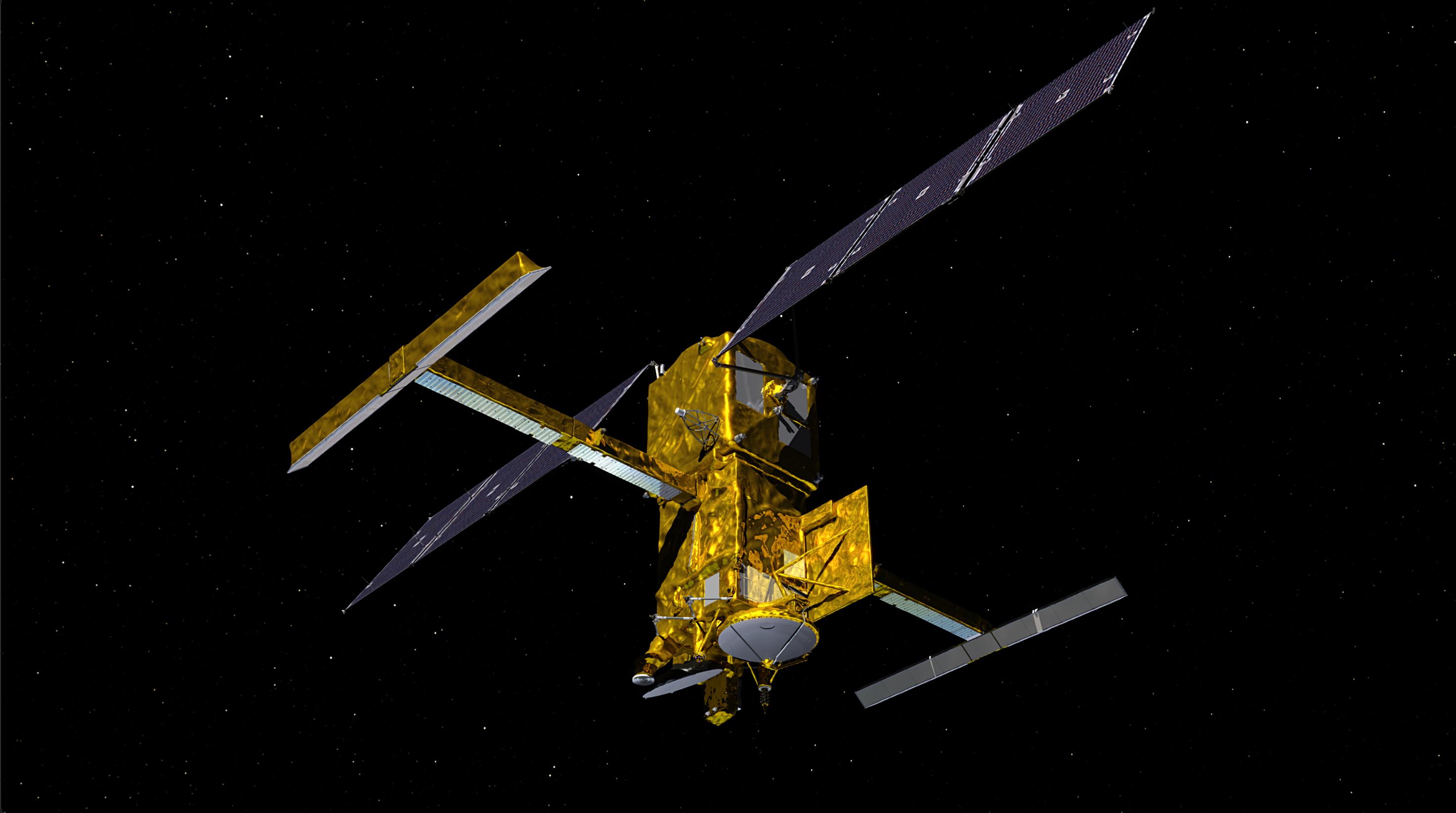
-
PIA24530:
-
SWOT in Orbit With View of KaRIn Instrument (Illustration)
Full Resolution:
TIFF
(3.918 MB)
JPEG
(217.8 kB)
|
|
|
2022-11-14 |
Earth
|
Surface Water and Ocean Topography (SWOT)
|
|
1920x1080x3 |
|
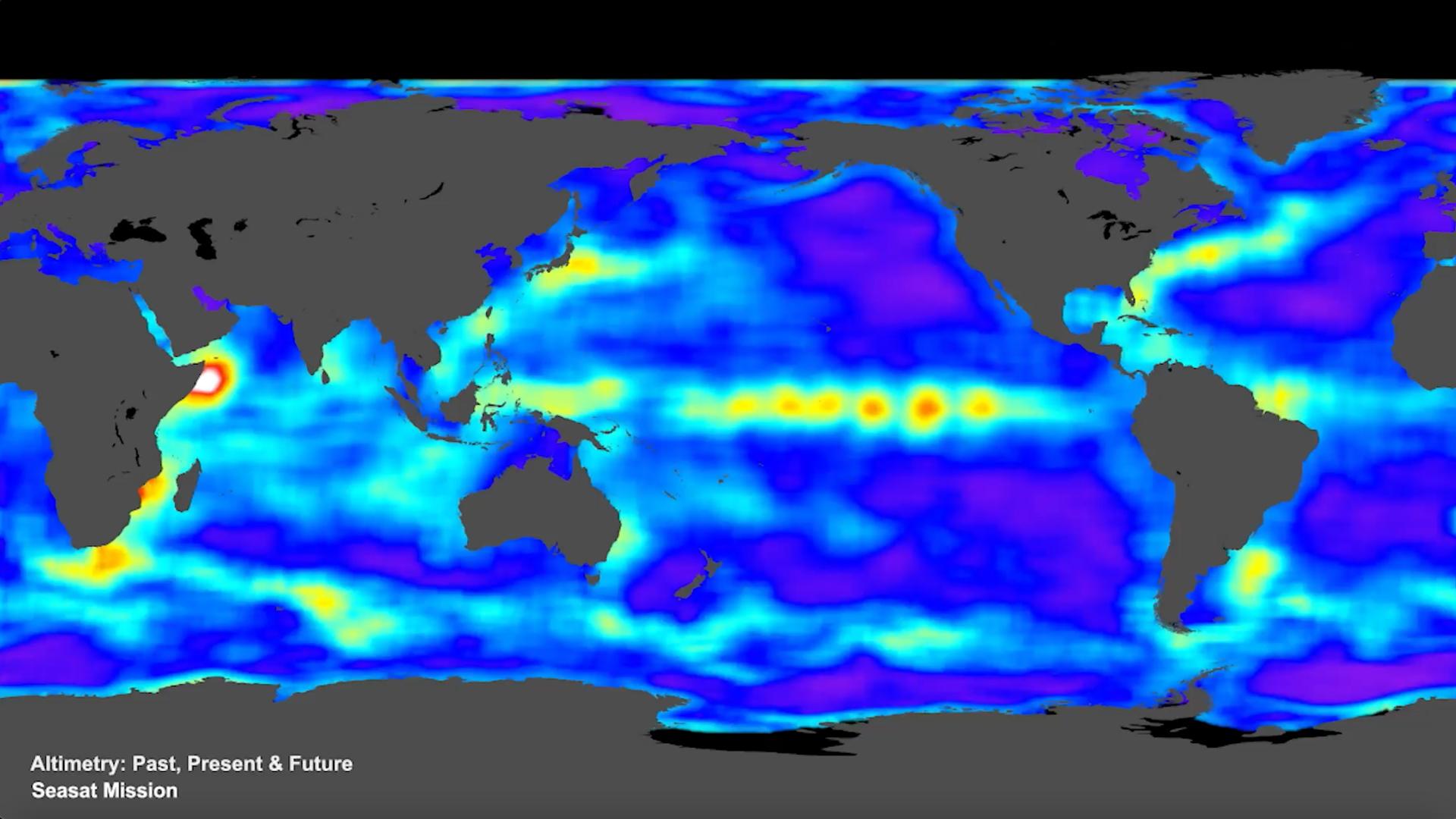
-
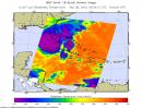
PIA25561:
-
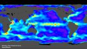
SWOT Satellite will Improve Clarity and Detail of Sea Height Measurements
Full Resolution:
TIFF
(3.673 MB)
JPEG
(154 kB)
|
|
|
2022-11-11 |
Eagle Nebula
|
Wide-field Infrared Survey Explorer (WISE)
|
|
3400x3400x3 |
|
-
PIA25433:
-
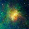
The Eagle Nebula Observed by WISE
Full Resolution:
TIFF
(34.69 MB)
JPEG
(1.01 MB)
|
|
|
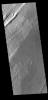
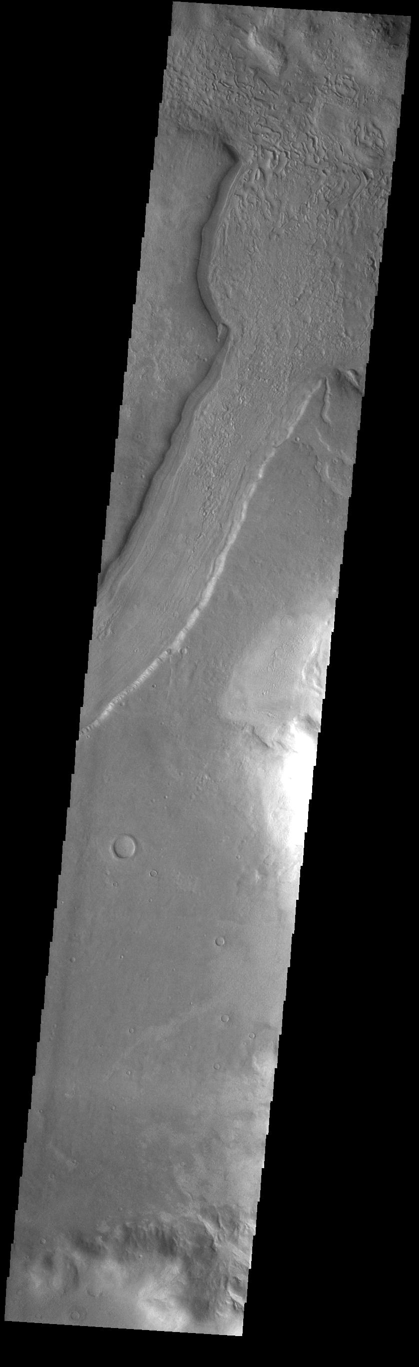
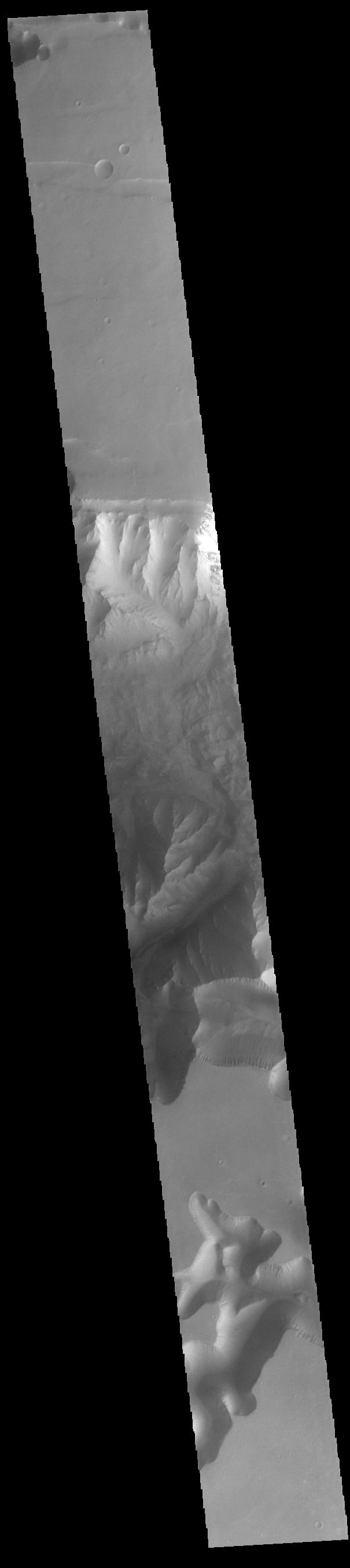
2022-11-07 |
Mars
|
2001 Mars Odyssey
|
THEMIS
|
839x2736x1 |

|
-
PIA25606:
-
Reull Vallis
Full Resolution:
TIFF
(1.392 MB)
JPEG
(165 kB)
|
|
|
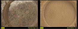
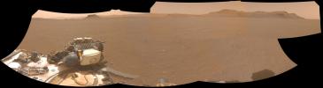
2022-11-03 |
Mars
|
Mars 2020 Rover
|
|
1630x1557x3 |
|
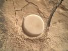
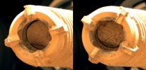
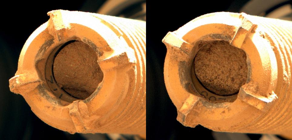
-
PIA25337:
-
CacheCam Image of Perseverance's 14th Sample of Martian Rock
Full Resolution:
TIFF
(6.384 MB)
JPEG
(312 kB)
|
|
|
2022-11-02 |
Mars
|
2001 Mars Odyssey
|
THEMIS
|
598x2704x1 |

|
-
PIA25603:
-
Arsia Mons
Full Resolution:
TIFF
(715 kB)
JPEG
(91.93 kB)
|
|
|
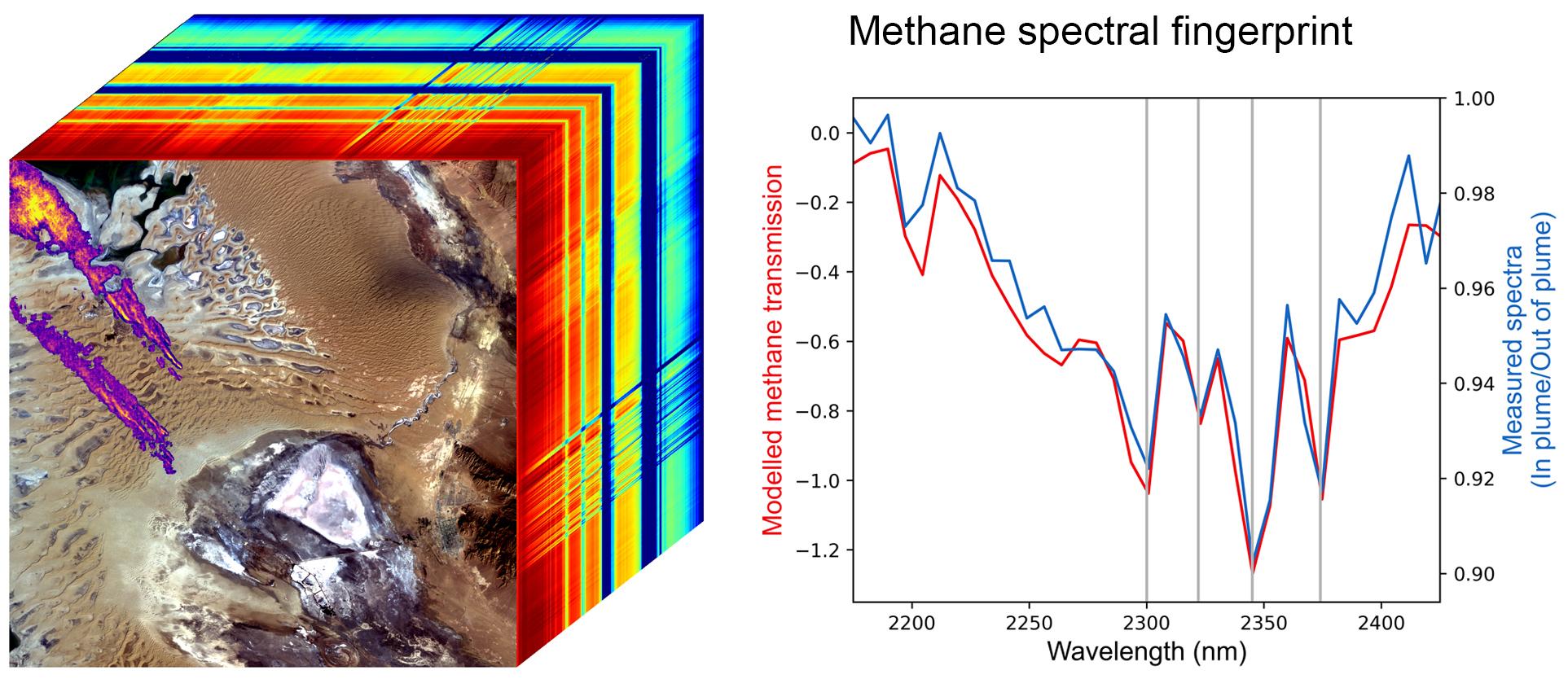
2022-10-25 |
Earth
|
Earth Surface Mineral Dust Source Investigation (EMIT)
|
EMIT
|
1925x834x3 |
|
-
PIA25593:
-
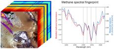
EMIT Methane Spectral Fingerprint
Full Resolution:
TIFF
(2.575 MB)
JPEG
(246.3 kB)
|
|
|
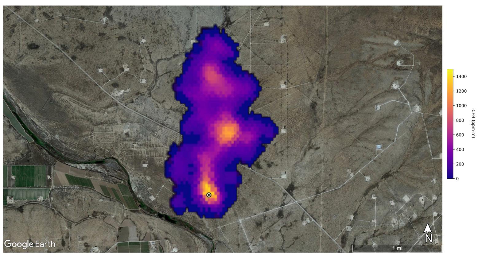
2022-10-25 |
Earth
|
Earth Surface Mineral Dust Source Investigation (EMIT)
|
EMIT
|
1557x834x3 |
|
-
PIA25592:
-
EMIT Spots Methane Hotspots
Full Resolution:
TIFF
(3.464 MB)
JPEG
(204.9 kB)
|
|
|
2022-10-25 |
Mars
|
2001 Mars Odyssey
|
THEMIS
|
605x2709x1 |

|
-
PIA25577:
-
Ius Chasma
Full Resolution:
TIFF
(690.6 kB)
JPEG
(65.92 kB)
|
|
|
2022-10-20 |
|
Surface Water and Ocean Topography (SWOT)
|
|
2179x1547x3 |

|
-
PIA25591:
-
SWOT Arrives at Vandenberg Space Force Base
Full Resolution:
TIFF
(7.499 MB)
JPEG
(331.9 kB)
|
|
|
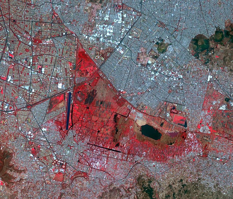
2022-10-19 |
Earth
|
Terra
|
ASTER
|
898x768x3 |
|
-
PIA25555:
-
Xochimilco, Mexico
Full Resolution:
TIFF
(2.07 MB)
JPEG
(234.4 kB)
|
|
|
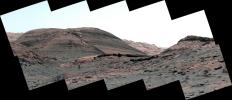
2022-10-19 |
Mars
|
Mars Science Laboratory (MSL)
|
Mastcam
|
2073x1226x3 |
|
-
PIA25415:
-
Curiosity's Close-Up of Rocks in Paraitepuy Pass
Full Resolution:
TIFF
(7.414 MB)
JPEG
(582.7 kB)
|
|
|
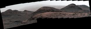
2022-10-19 |
Mars
|
Mars Science Laboratory (MSL)
|
Mastcam
|
8323x4225x3 |
|
-
PIA25414:
-
Curiosity's View of Sand Ridges and Bolívar
Full Resolution:
TIFF
(78.61 MB)
JPEG
(6.244 MB)
|
|
|
2022-10-19 |
Mars
|
Mars Science Laboratory (MSL)
|
Mastcam
|
29163x8638x3 |
|
-
PIA25413:
-
Curiosity's View of Paraitepuy Pass
Full Resolution:
TIFF
(536.6 MB)
JPEG
(46.38 MB)
|
|
|
2022-10-18 |
|
Surface Water and Ocean Topography (SWOT)
|
|
6048x3749x3 |
|
-
PIA24910:
-
Packing SWOT For Launch
Full Resolution:
TIFF
(53.66 MB)
JPEG
(2.978 MB)
|
|
|
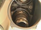
2022-10-13 |
Phobos
|
Mars 2020 Rover
|
Mastcam-Z
|
1600x1200x1 |

|
-
PIA25419:
-
Perseverance Views Phobos
Full Resolution:
TIFF
(621.7 kB)
JPEG
(65.47 kB)
|
|
|
2022-10-12 |
Mars
|
Mars Sample Return (MSR)
|
|
1050x591x3 |

|
-
PIA25336:
-
Mars Earth Entry System Aeroshell at Entry (Illustration)
Full Resolution:
TIFF
(739.4 kB)
JPEG
(17.89 kB)
|
|
|
2022-10-12 |
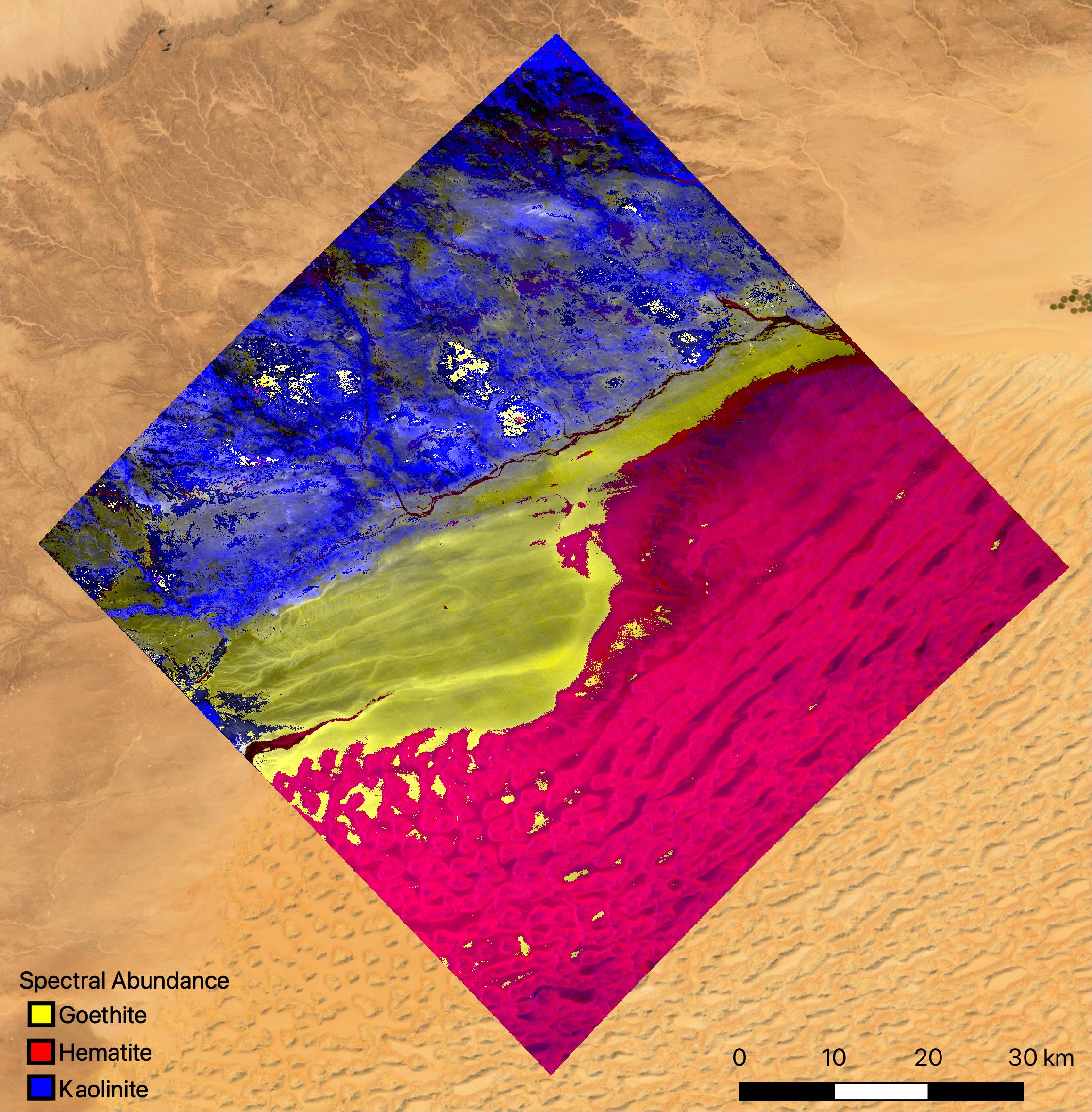
Earth
|
Earth Surface Mineral Dust Source Investigation (EMIT)
|
EMIT
|
2457x2370x3 |
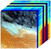
|
-
PIA25430:
-
NASA's EMIT Mission Generates Image Cube of Surface Minerals in Southwestern Libya
Full Resolution:
TIFF
(15.61 MB)
JPEG
(788.9 kB)
|
|
|
2022-10-12 |
Earth
|
Earth Surface Mineral Dust Source Investigation (EMIT)
|
EMIT
|
1489x1039x3 |

|
-
PIA25429:
-
NASA's EMIT Measures Surface Dust in North Africa, Europe, the Middle East, Central Asia
Full Resolution:
TIFF
(4.643 MB)
JPEG
(393.1 kB)
|
|
|
2022-10-12 |
Earth
|
Earth Surface Mineral Dust Source Investigation (EMIT)
|
EMIT
|
1435x891x3 |

|
-
PIA25428:
-
NASA's EMIT Collects Mineral Maps, Spectral Fingerprints From Nevada
Full Resolution:
TIFF
(1.876 MB)
JPEG
(184.9 kB)
|
|
|
2022-10-12 |
Earth
|
Earth Surface Mineral Dust Source Investigation (EMIT)
|
EMIT
|
774x750x3 |
|
-
PIA25427:
-
NASA's EMIT Generates Image Cube of Surface Minerals in Northwest Nevada
Full Resolution:
TIFF
(1.689 MB)
JPEG
(146.8 kB)
|
|
|
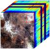
2022-10-12 |
Earth
|
Earth Surface Mineral Dust Source Investigation (EMIT)
|
EMIT
|
2249x2289x3 |

|
-
PIA25424:
-
EMIT Instrument's First Light
Full Resolution:
TIFF
(14.73 MB)
JPEG
(813.9 kB)
|
|
|
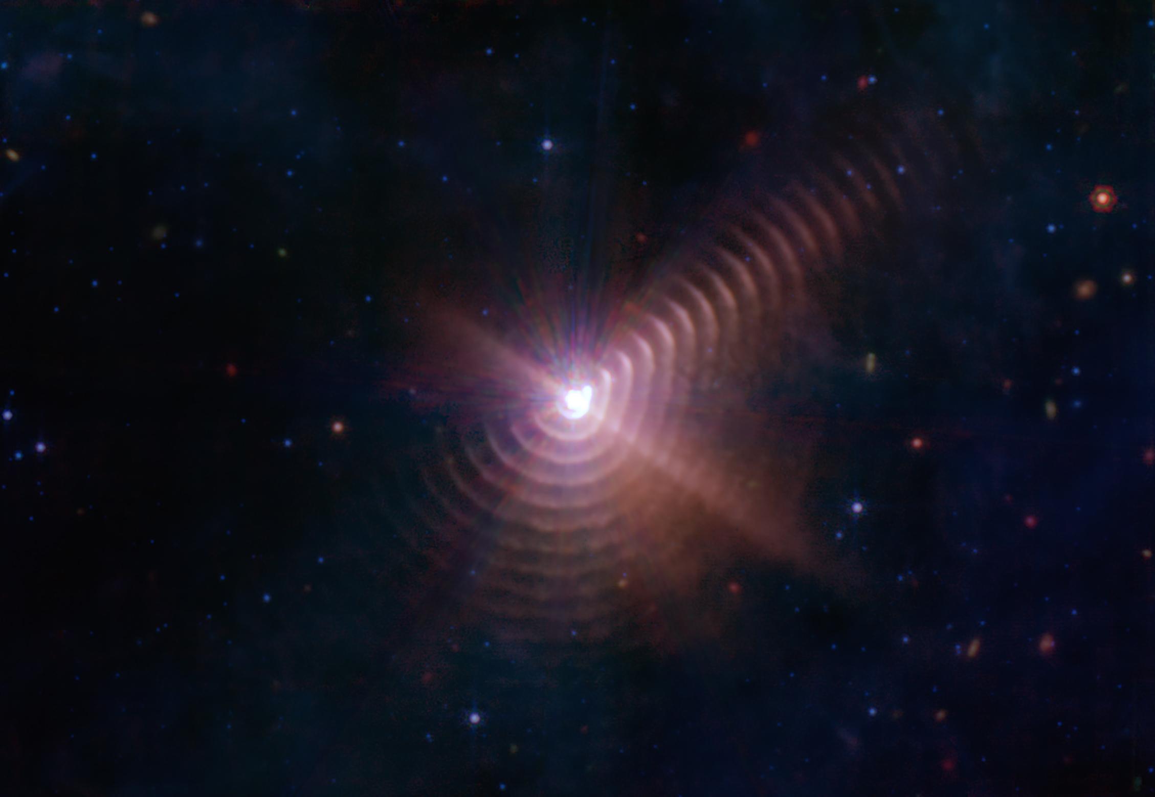
2022-10-12 |
Star
|
James Webb Space Telescope
|
Mid-Infrared Instrument (MIRI)
|
2258x1558x3 |

|
-
PIA25432:
-
Dust Rings in the Wolf-Rayet 140 System
Full Resolution:
TIFF
(6.995 MB)
JPEG
(122.5 kB)
|
|
|
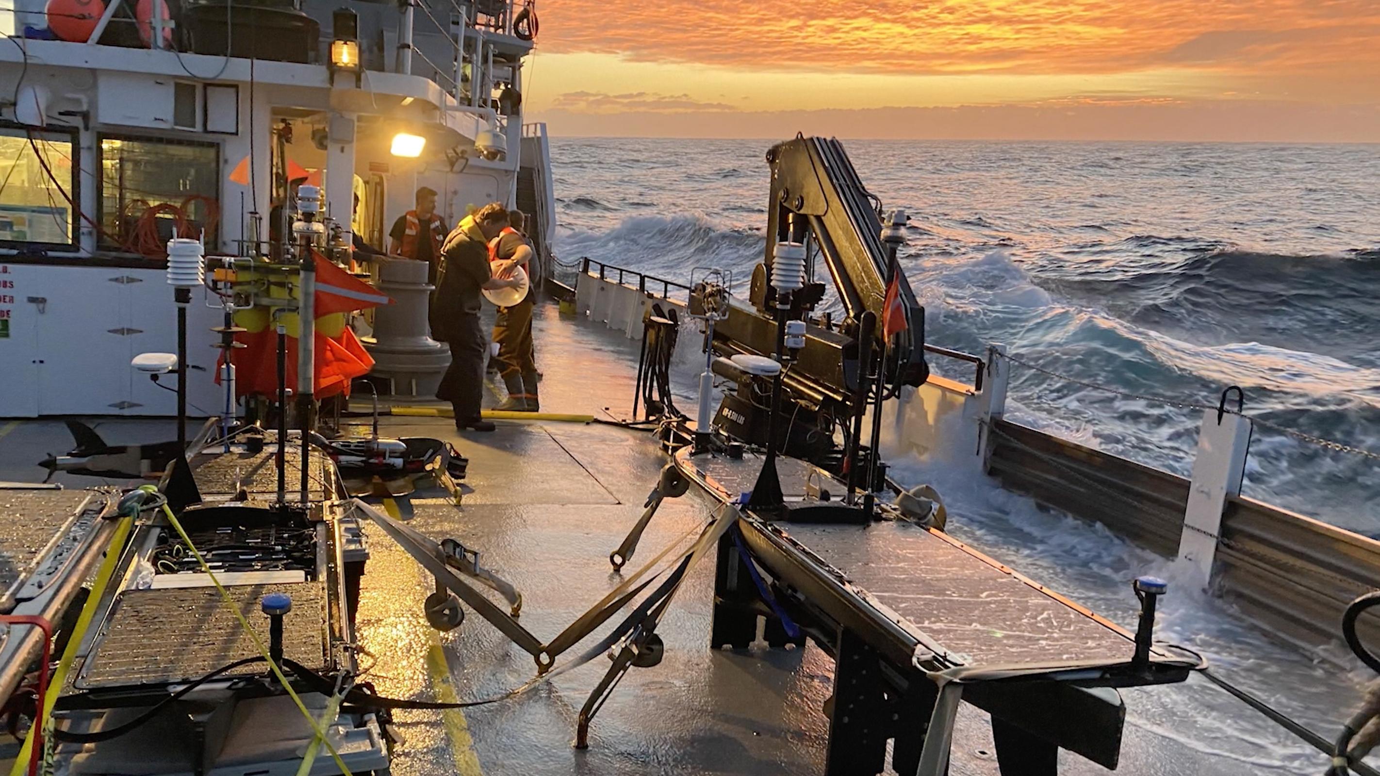
2022-10-11 |
Earth
|
S-MODE
|
|
4032x3024x3 |
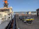
|
-
PIA25524:
-
S-MODE Research Vessel and Marine Robots Prepare for Sea
Full Resolution:
TIFF
(29.16 MB)
JPEG
(1.602 MB)
|
|
|
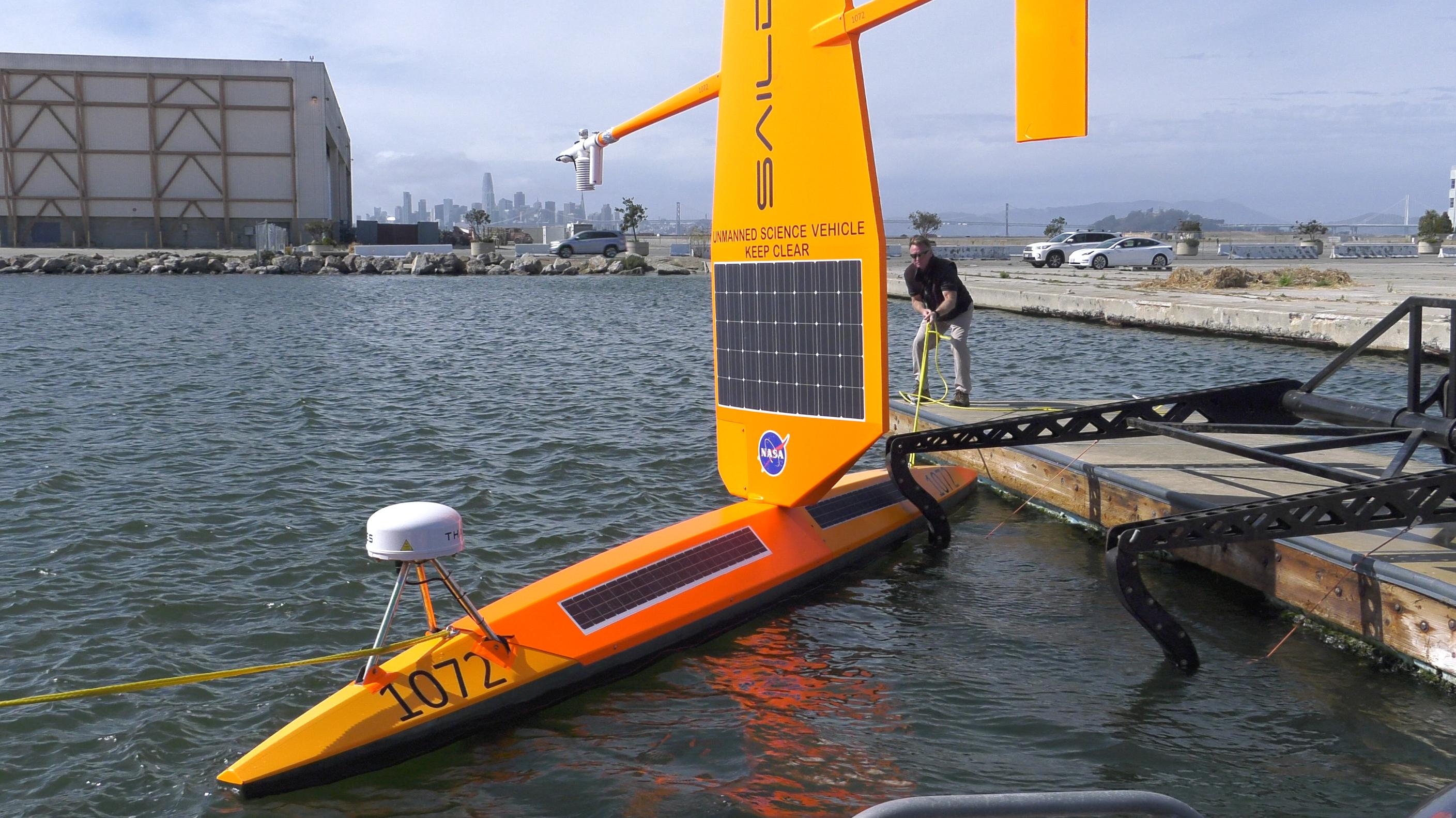
2022-10-11 |
Earth
|
S-MODE
|
|
2817x1582x3 |
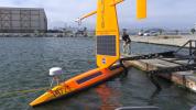
|
-
PIA25523:
-
S-MODE Saildrone in San Francisco Waters
Full Resolution:
TIFF
(12.59 MB)
JPEG
(601.8 kB)
|
|
|
2022-10-11 |
Earth
|
S-MODE
|
|
2844x1599x3 |

|
-
PIA25522:
-
High Seas at Sunset During S-MODE Field Campaign
Full Resolution:
TIFF
(13.65 MB)
JPEG
(611.5 kB)
|
|
|
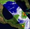
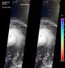
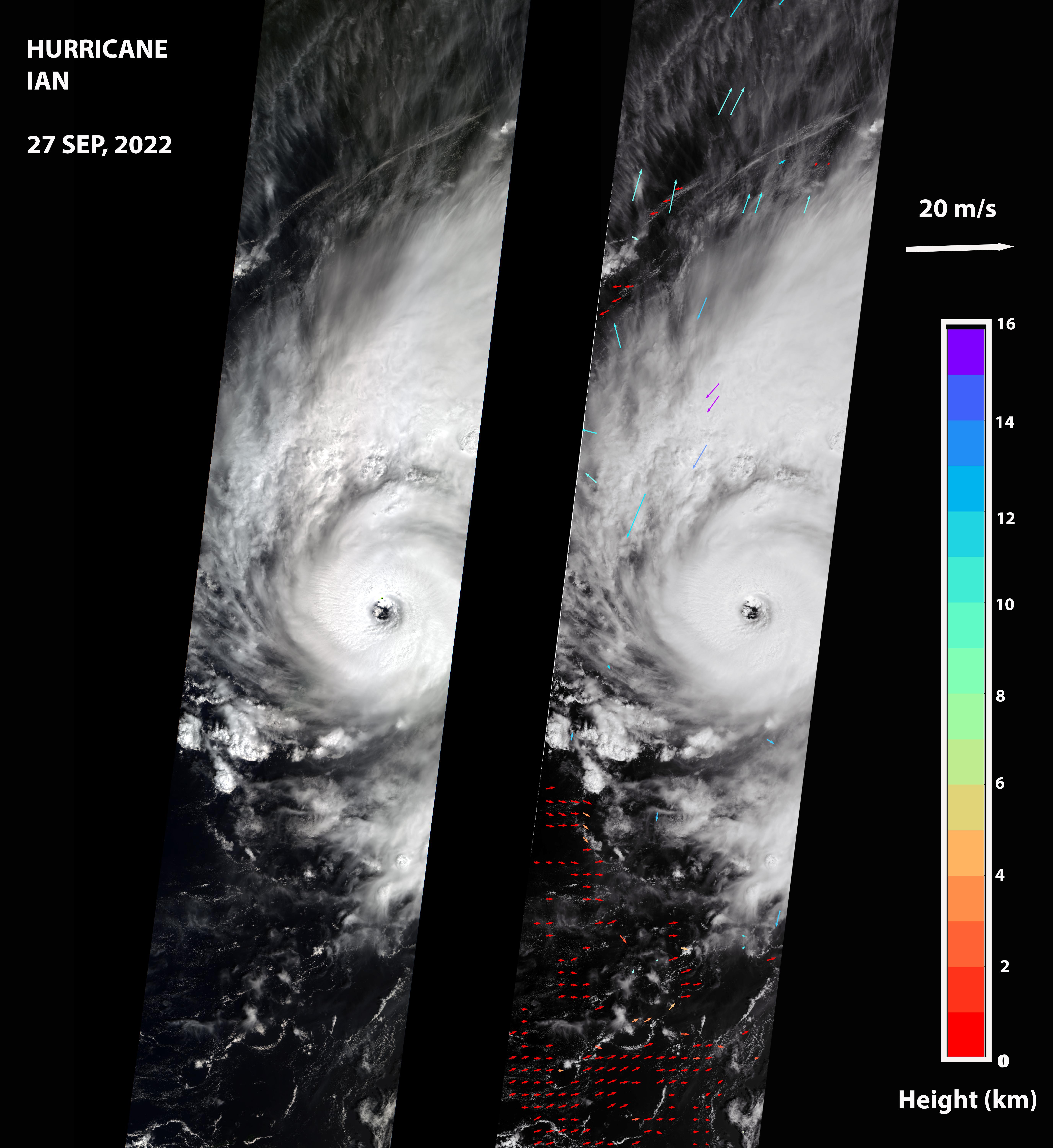
2022-09-30 |
Earth
|
Terra
|
MISR
|
5504x6001x3 |
|
-
PIA24909:
-
MISR Captures Hurricane Ian
Full Resolution:
TIFF
(34.94 MB)
JPEG
(1.738 MB)
|
|
|
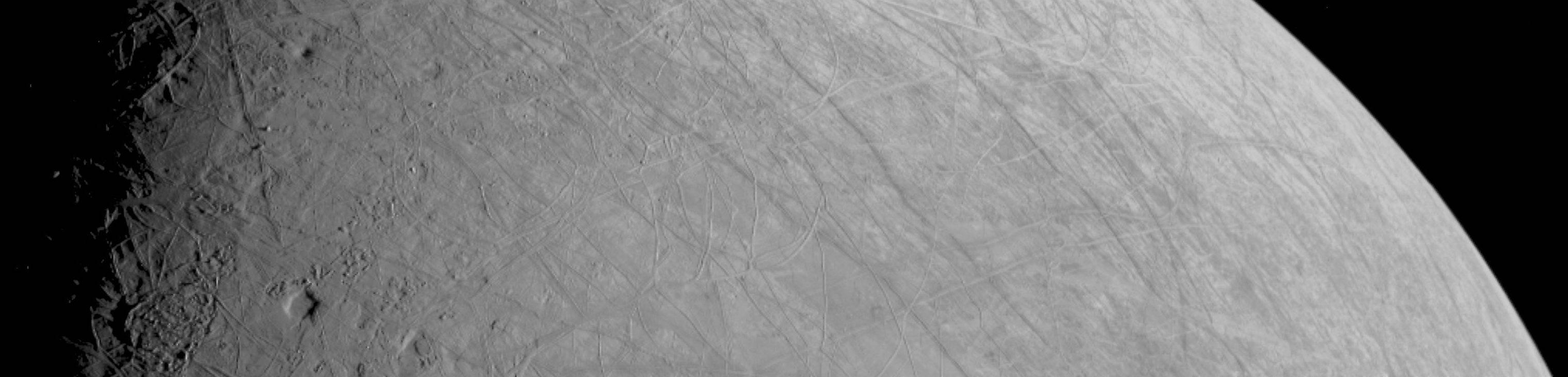
2022-09-29 |
Europa
|
Juno
|
JunoCam
|
3037x730x1 |

|
-
PIA25330:
First Image of Europa From Juno's Close Flyby
Full Resolution:
TIFF
(1.766 MB)
JPEG
(187.3 kB)
|
|
|
2022-09-28 |
Earth
|
COWVR
|
COWVR
TEMPEST
|
1564x1527x3 |
|
-
PIA25425:
-
COWVR and TEMPEST Image Hurricane Ian
Full Resolution:
TIFF
(5.736 MB)
JPEG
(250.1 kB)
|
|
|
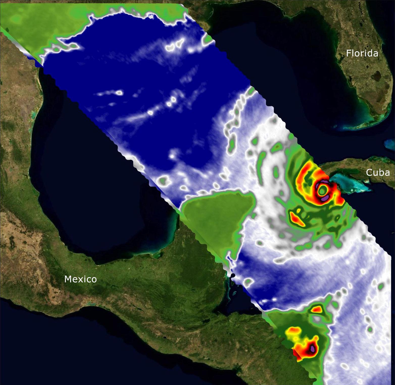
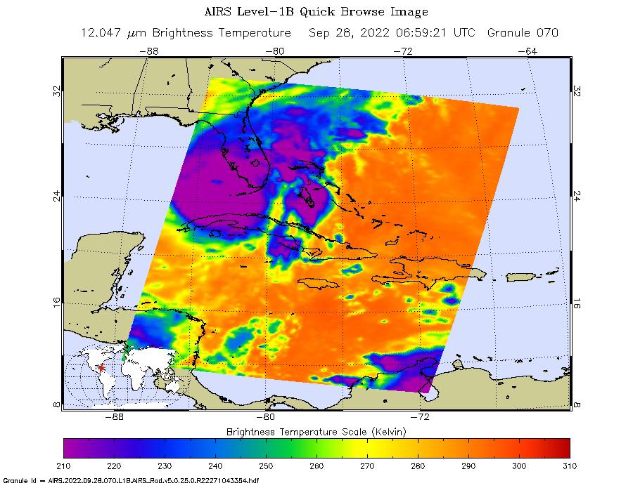
2022-09-28 |
Earth
|
Aqua
|
AIRS
|
900x695x3 |
|
-
PIA24908:
-
Hurricane Ian Captured in Infrared by AIRS
Full Resolution:
TIFF
(808.6 kB)
JPEG
(116 kB)
|
|
|
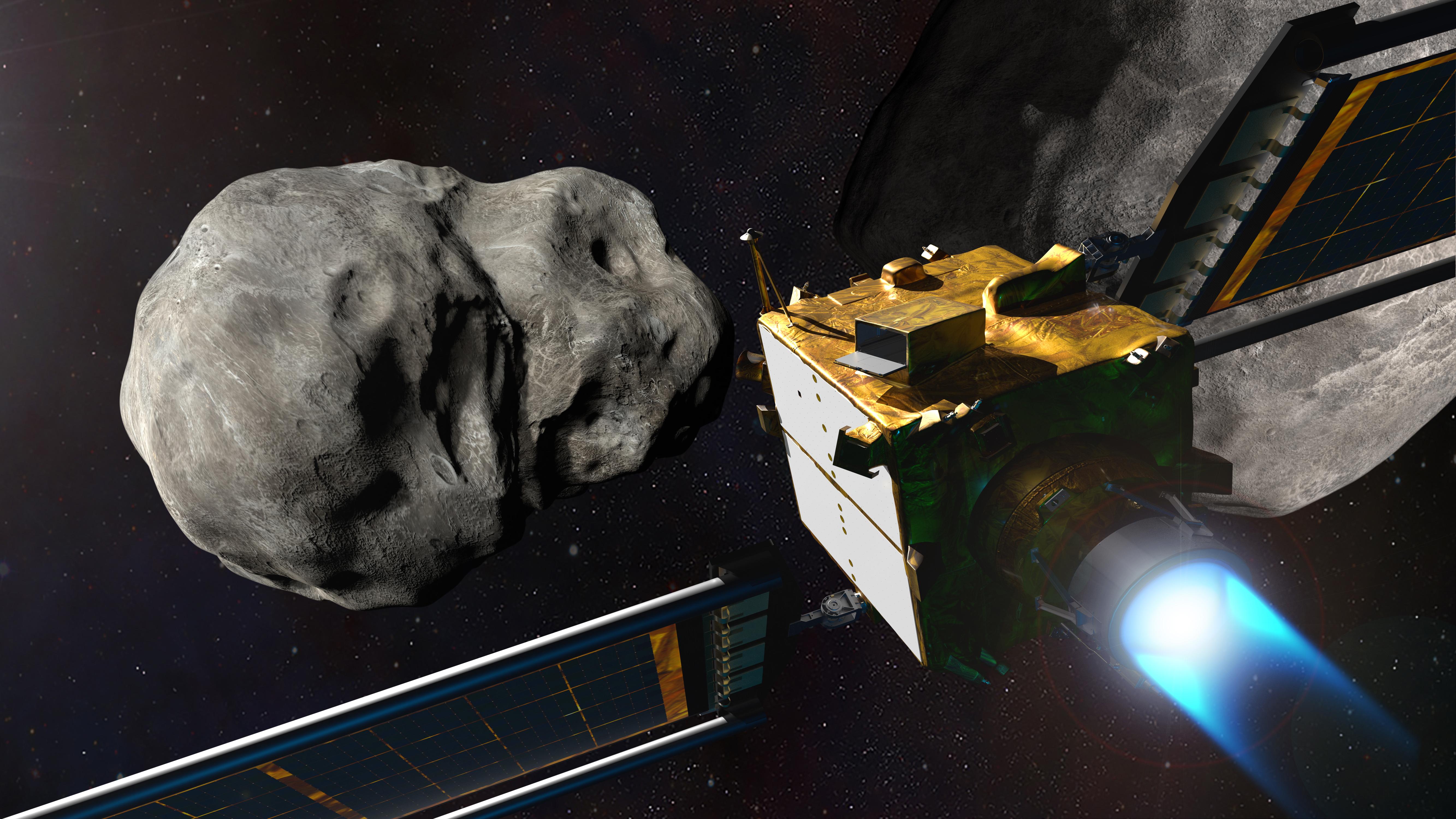
2022-09-22 |
Asteroid
|
Double Asteroid Redirection Test (DART)
|
|
5333x3000x3 |

|
-
PIA25329:
-
NASA's DART at the Didymos System
Full Resolution:
TIFF
(34.68 MB)
JPEG
(1.268 MB)
|
|
|
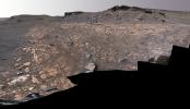
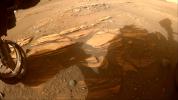
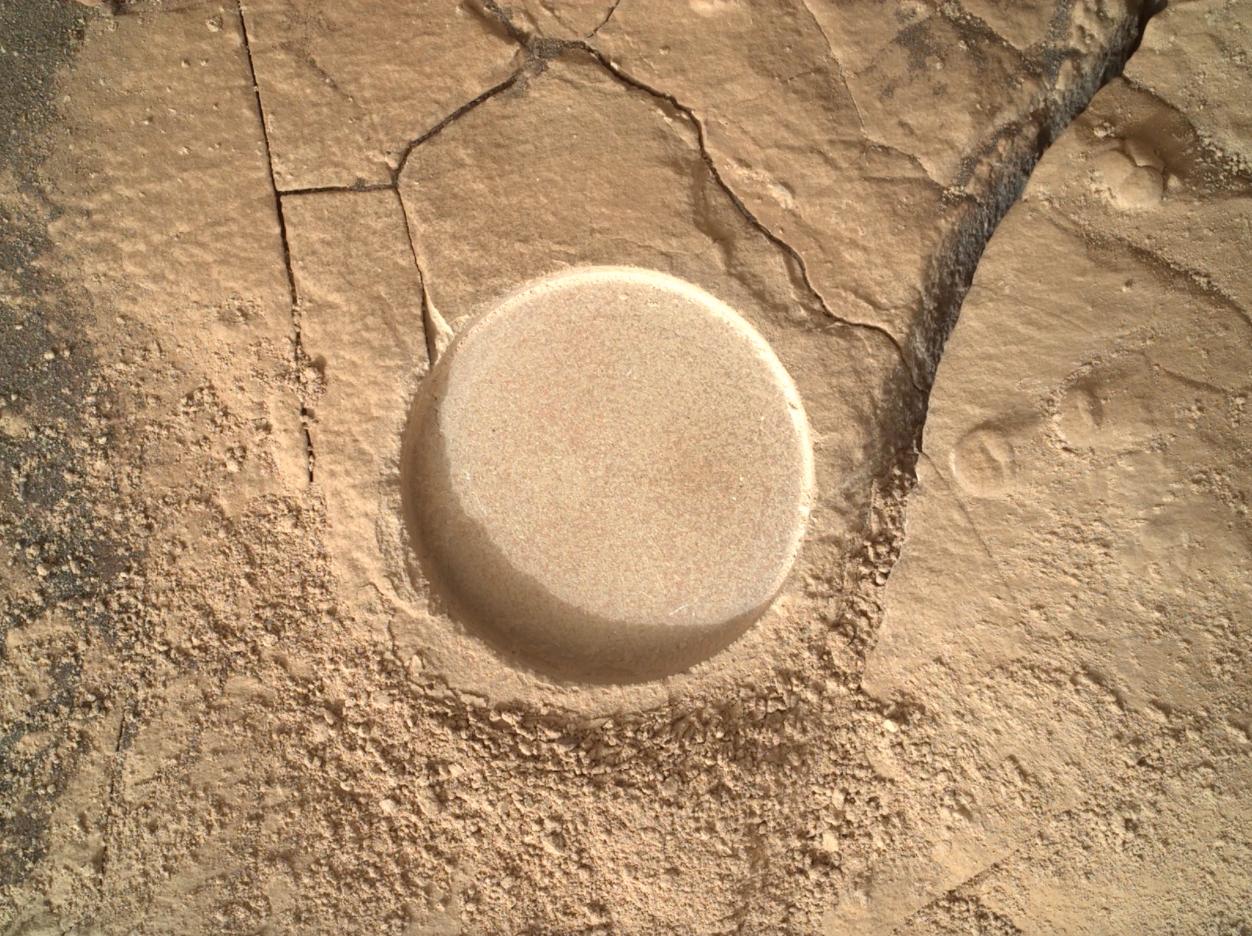
2022-09-15 |
Mars
|
Mars 2020 Rover
|
Scanning Habitable Environments with Raman & Luminescence for Organics and Chemicals (SHERLOC)
|
1252x936x3 |
|
-
PIA25246:
-
Zooming in on Perseverance Rover's Wildcat Ridge Abrasion Patch
Full Resolution:
TIFF
(3.517 MB)
JPEG
(259.4 kB)
|
|
|
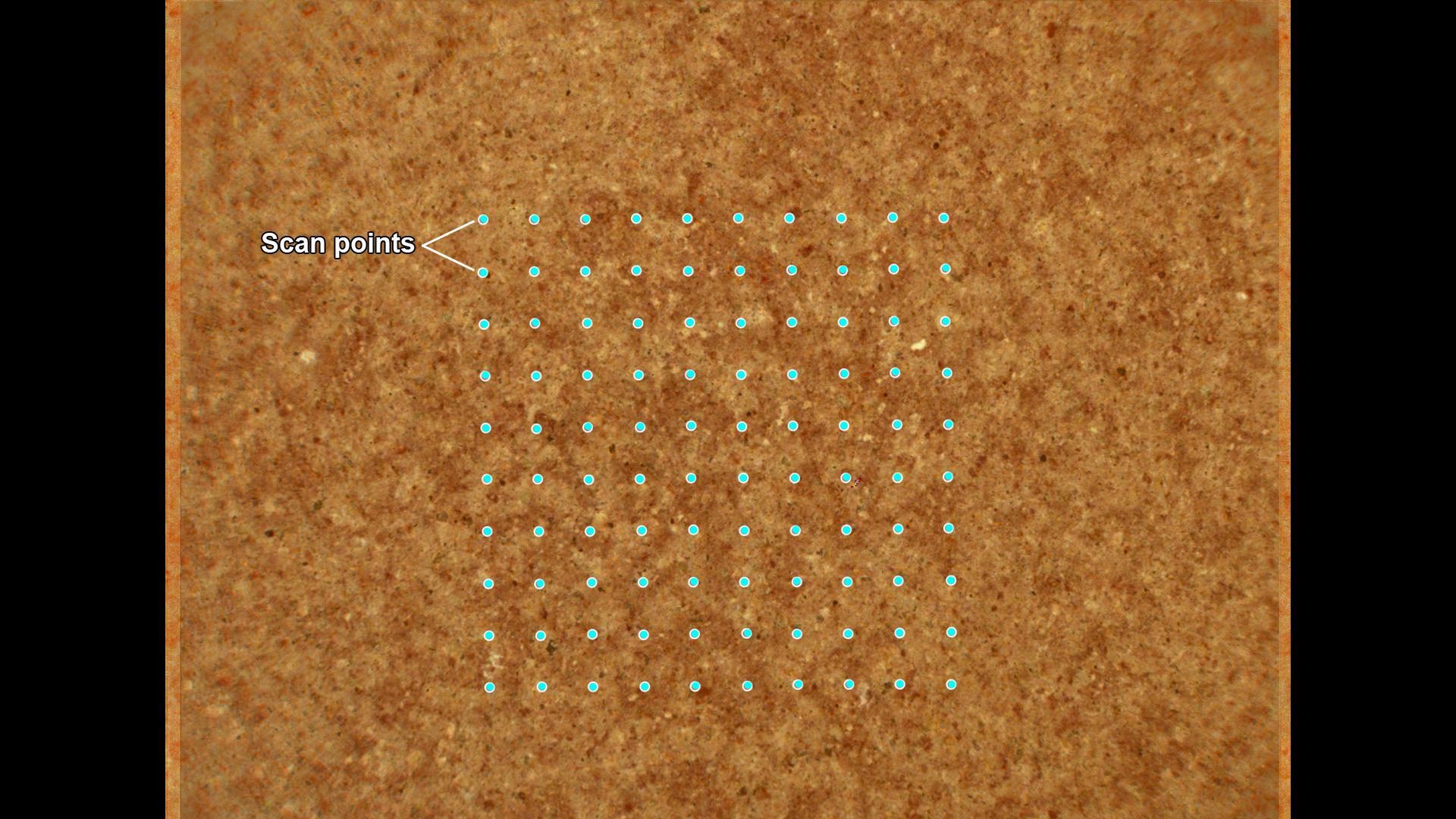
2022-09-15 |
Mars
|
Mars 2020 Rover
|
Scanning Habitable Environments with Raman & Luminescence for Organics and Chemicals (SHERLOC)
|
1920x1080x3 |

|
-
PIA25245:
-
How SHERLOC Analyzes a Rock Target
Full Resolution:
TIFF
(5.365 MB)
JPEG
(283.3 kB)
|
|
|
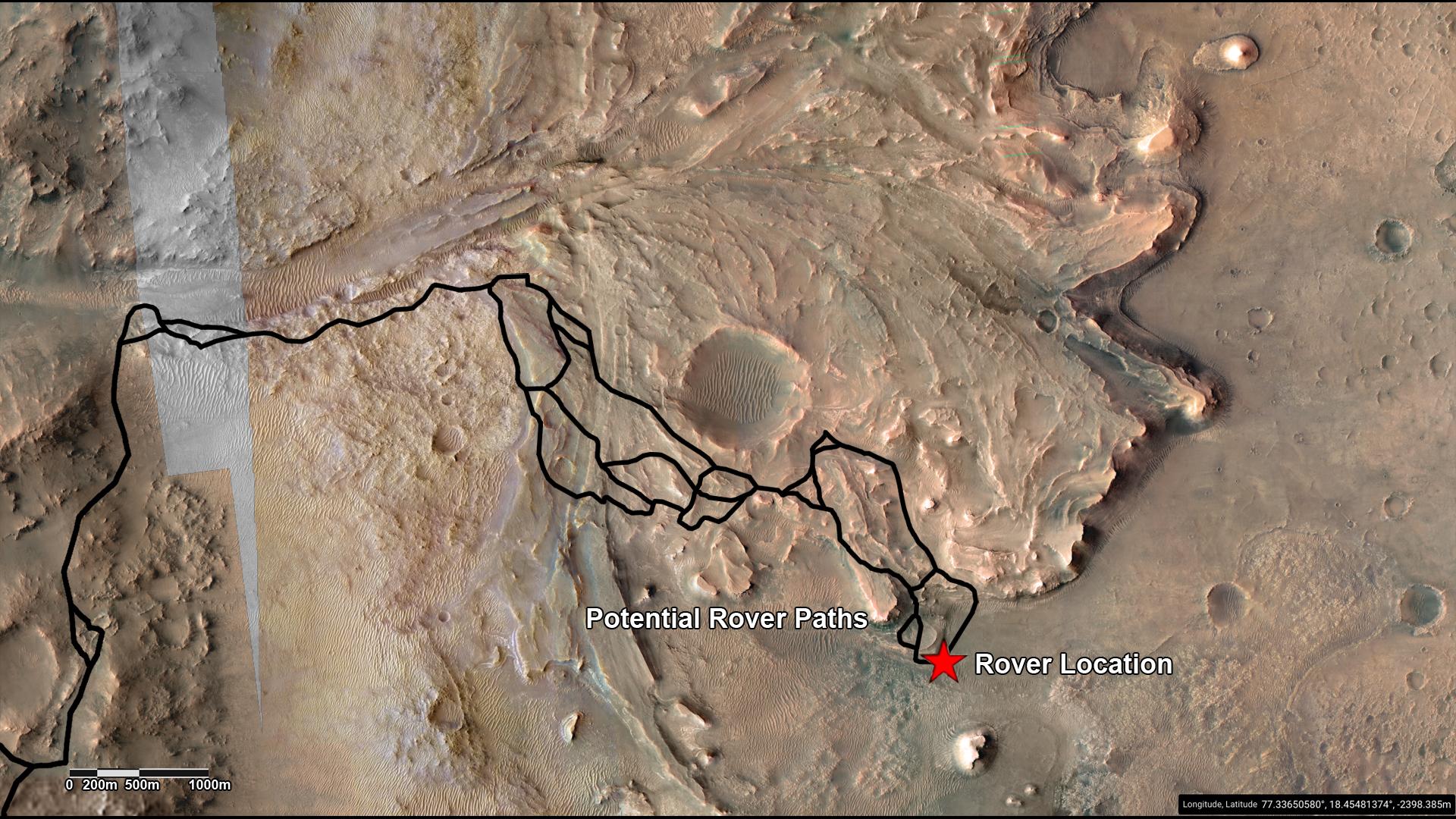
2022-09-15 |
Mars
|
Mars Reconnaissance Orbiter (MRO)
|
CRISM
HiRISE
|
1920x1080x3 |
|
-
PIA25244:
-
Potential Driving Routes for NASA's Perseverance Rover
Full Resolution:
TIFF
(6.223 MB)
JPEG
(406.8 kB)
|
|
|
2022-09-15 |
Mars
|
Mars 2020 Rover
|
Navigation Camera (M2020)
|
1620x1080x3 |
|
-
PIA25243:
-
Perseverance's View of Possible Future Sample Cache Depot Site
Full Resolution:
TIFF
(5.251 MB)
JPEG
(217.7 kB)
|
|
|
2022-09-15 |
Mars
|
Mars 2020 Rover
|
Mastcam-Z
|
964x463x3 |
|
-
PIA24929:
-
Perseverance Rock Cores From Wildcat Ridge
Full Resolution:
TIFF
(1.302 MB)
JPEG
(63.69 kB)
|
|
|
2022-09-15 |
Mars
|
Mars 2020 Rover
|
Mastcam-Z
|
3225x2631x3 |

|
-
PIA24928:
-
Sample Collection and Rock Analysis at Wildcat Ridge
Full Resolution:
TIFF
(17.01 MB)
JPEG
(1.04 MB)
|
|
|
2022-09-15 |
Mars
|
Mars 2020 Rover
|
Mastcam-Z
|
844x412x3 |

|
-
PIA24927:
-
Rock Cores From Skinner Ridge
Full Resolution:
TIFF
(1.044 MB)
JPEG
(61.1 kB)
|
|
|
2022-09-15 |
Mars
|
Mars 2020 Rover
|
Scanning Habitable Environments with Raman & Luminescence for Organics and Chemicals (SHERLOC)
|
1962x752x3 |
|
-
PIA24926:
-
2 Abrasion Patches From Perseverance at Jezero Delta
Full Resolution:
TIFF
(4.01 MB)
JPEG
(209 kB)
|
|
|
2022-09-15 |
Mars
|
Mars 2020 Rover
|
Mastcam-Z
|
13235x7349x3 |
|
-
PIA24925:
-
Perseverance Workspace at Skinner Ridge
Full Resolution:
TIFF
(201.6 MB)
JPEG
(8.688 MB)
|
|
|
2022-09-15 |
Mars
|
Mars 2020 Rover
|
Mastcam-Z
|
15261x8765x3 |
|
-
PIA24924:
-
2 Perseverance Sampling Locations in Jezero's Delta
Full Resolution:
TIFF
(292.2 MB)
JPEG
(17.42 MB)
|
|
|
2022-09-15 |
Mars
|
Mars Reconnaissance Orbiter (MRO)
|
HiRISE
|
1920x1080x3 |
|
-
PIA24923:
-
Perseverance Exploring the Front of the Delta
Full Resolution:
TIFF
(6.111 MB)
JPEG
(355.5 kB)
|
|
|
2022-09-15 |
Mars
|
Mars Reconnaissance Orbiter (MRO)
|
CRISM
HiRISE
|
1920x1080x3 |
|
-
PIA24922:
-
Perseverance's Route to the Delta
Full Resolution:
TIFF
(5.008 MB)
JPEG
(256 kB)
|
|
|
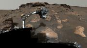
2022-09-14 |
Mars
|
Mars 2020 Rover
|
Mastcam-Z
|
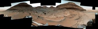
29163x8182x3 |
|
-
PIA24921:
Detailed Panorama of Mars' Jezero Crater Delta
Full Resolution:
TIFF
(457.2 MB)
JPEG
(26.18 MB)
|
|
|
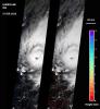
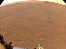
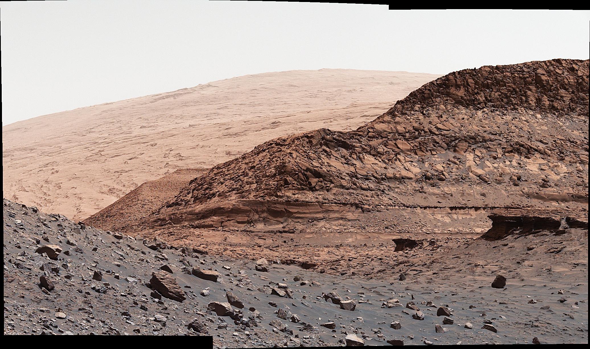
2022-09-08 |
Earth
|
Aqua
|
AIRS
|
900x695x3 |
|
-
PIA25521:
-
AIRS Images Typhoon Hinnamnor Ahead of Landfall
Full Resolution:
TIFF
(825.3 kB)
JPEG
(112.9 kB)
|
|
|
2022-09-06 |
Mars
|
2001 Mars Odyssey
|
THEMIS
|
677x1418x1 |

|
-
PIA25512:
-
Louros Valles
Full Resolution:
TIFF
(634.1 kB)
JPEG
(52 kB)
|
|
|
2022-08-25 |
|
|
|
3329x2139x3 |

|
-
PIA25315:
-
NASA's MSI Space Accelerator at JPL
Full Resolution:
TIFF
(19.95 MB)
JPEG
(1.182 MB)
|
|
|
2022-08-24 |
Europa
|
Europa Clipper
|
|
4000x3000x3 |
|
-
PIA25493:
-
NASA's Europa Clipper: Vault and Nadir Deck on the Move
Full Resolution:
TIFF
(29.35 MB)
JPEG
(1.119 MB)
|
|
|
2022-08-24 |
Europa
|
Europa Clipper
|
|
7981x5321x3 |
|
-
PIA25492:
-
Easy Does It: NASA's Europa Clipper Is Lowered Into Place
Full Resolution:
TIFF
(94.94 MB)
JPEG
(4.231 MB)
|
|
|
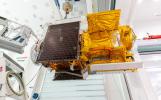
2022-08-24 |
Europa
|
Europa Clipper
|
|
8256x5504x3 |
|
-
PIA25491:
-
The Lift: NASA's Europa Clipper Moves Into Position
Full Resolution:
TIFF
(99.1 MB)
JPEG
(4.405 MB)
|
|
|
2022-08-24 |
Europa
|
Europa Clipper
|
|
8256x5504x3 |

|
-
PIA25240:
-
NASA's Europa Clipper Takes Center Stage
Full Resolution:
TIFF
(95.51 MB)
JPEG
(4.197 MB)
|
|
|
2022-08-23 |
Earth
|
Terra
|
ASTER
|
2064x971x3 |

|
-
PIA25501:
-
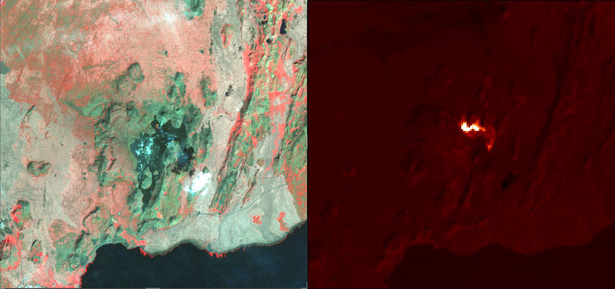
Fagradalsfjall Volcano, Iceland
Full Resolution:
TIFF
(4.702 MB)
JPEG
(214.2 kB)
|
|
|
2022-08-23 |
Earth
|
Terra
|
ASTER
|
1986x3125x3 |
|
-
PIA25446:
-
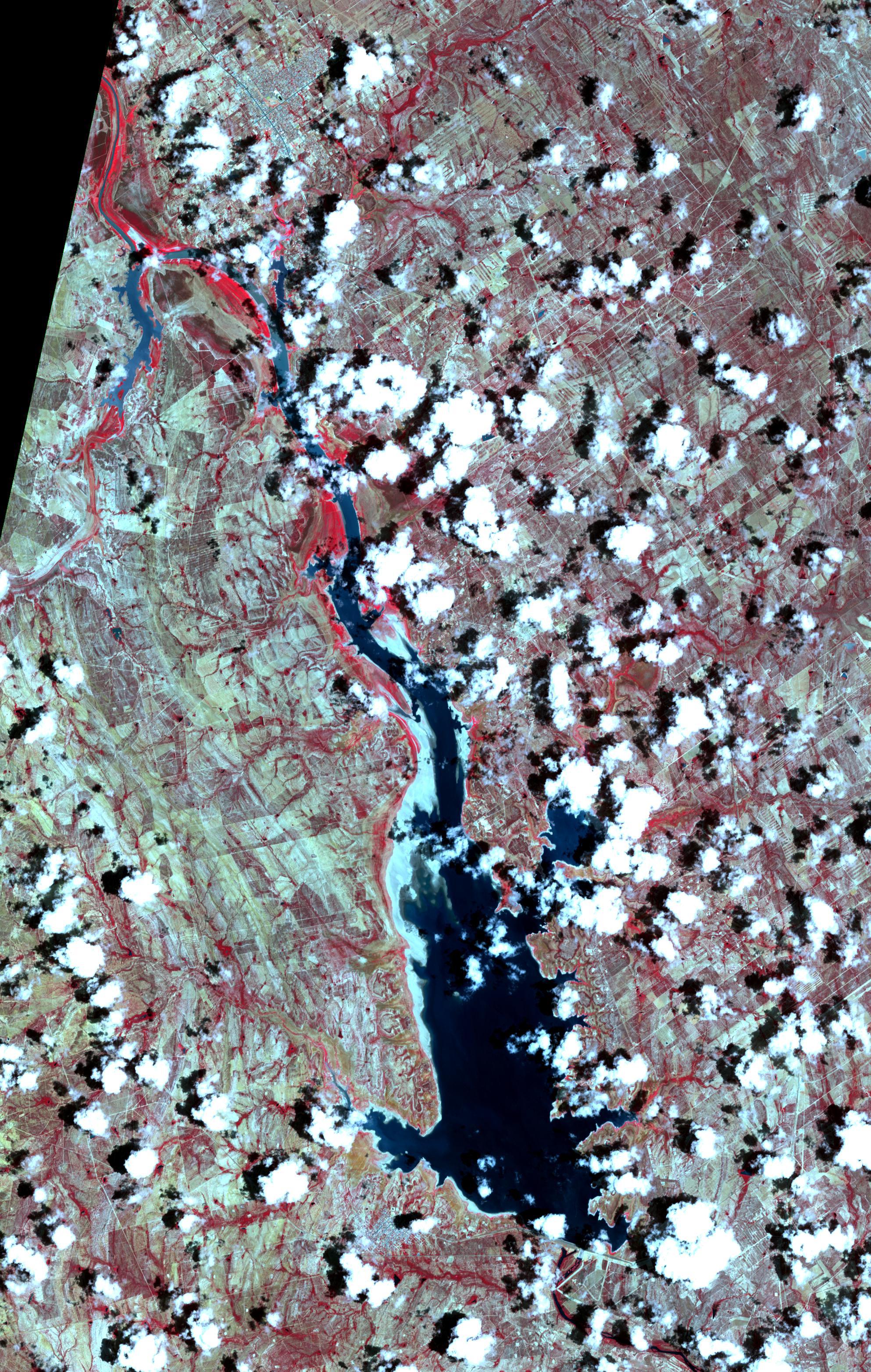
Falcon International Reservoir, US-Mexico - 2022
Full Resolution:
TIFF
(18.63 MB)
JPEG
(1.45 MB)
|
|
|
2022-08-19 |
Mars
|
Mars 2020 Rover
|
Scanning Habitable Environments with Raman & Luminescence for Organics and Chemicals (SHERLOC)
|
1584x1184x3 |
|
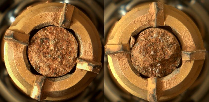
-
PIA25327:
-
Perseverance Coring Bit
Full Resolution:
TIFF
(5.323 MB)
JPEG
(141 kB)
|
|
|
2022-08-10 |
Earth
|
|
|
4456x5324x3 |
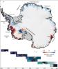
|
-
PIA24990:
-
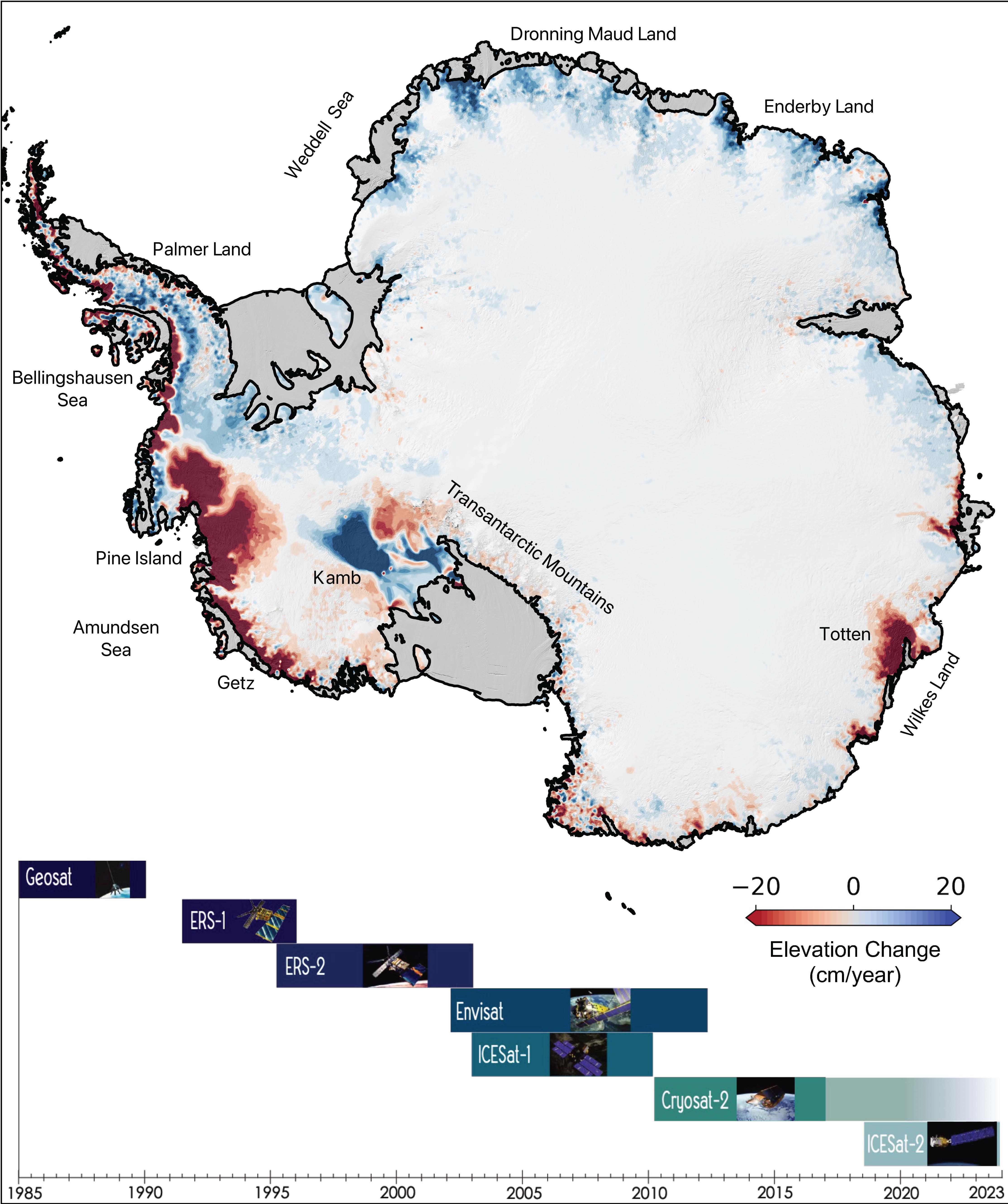
The Antarctic Ice Sheet's Changing Height
Full Resolution:
TIFF
(18.38 MB)
JPEG
(1.304 MB)
|
|
|
2022-08-05 |
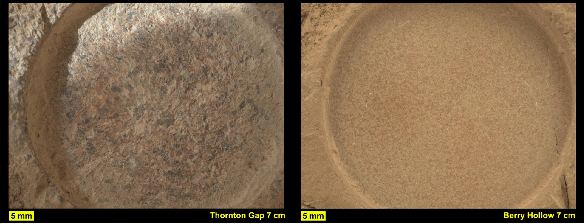
Mars
|
Mars Science Laboratory (MSL)
|
Mastcam
|
29163x8000x3 |
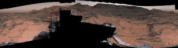
|
-
PIA25407:
Curiosity's 360-Degree Panorama of Avanavero Drill Site
Full Resolution:
TIFF
(495.9 MB)
JPEG
(38.13 MB)
|
|
|
2022-08-04 |
Earth
|
ECOSTRESS
|
|
3507x2480x3 |
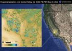
|
-
PIA25488:
-
Evapotranspiration over Central Valley
Full Resolution:
TIFF
(24.59 MB)
JPEG
(1.422 MB)
|
|
|
2022-08-04 |
Earth
|
ECOSTRESS
|
|
3507x2480x3 |
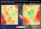
|
-
PIA25487:
-
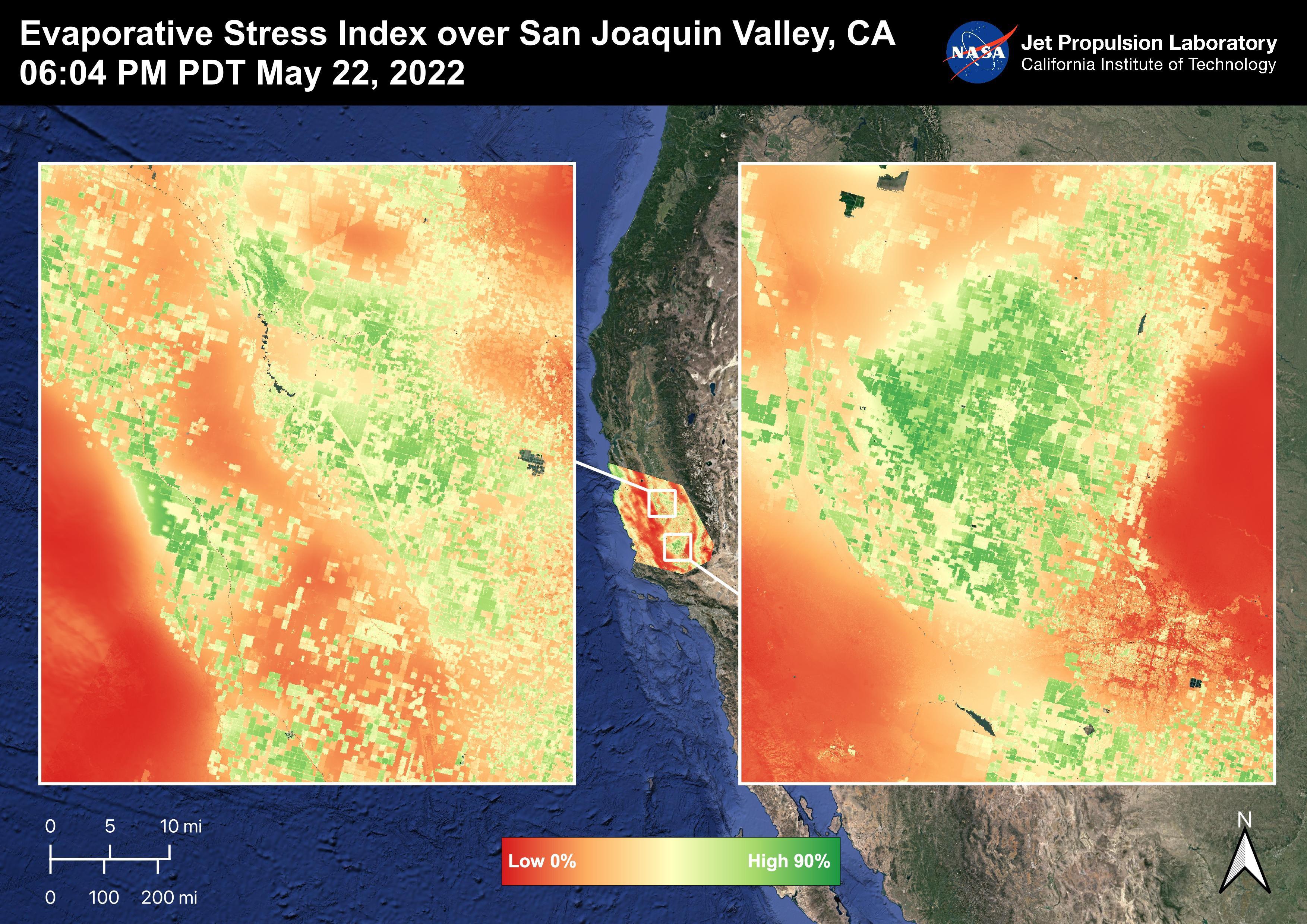
Evaporative Stress Index over San Joaquin Valley
Full Resolution:
TIFF
(24.55 MB)
JPEG
(1.344 MB)
|
|
|
2022-08-04 |
Earth
|
ECOSTRESS
|
|
3507x2480x3 |

|
-
PIA25486:
-
Evapotranspiration over San Joaquin Valley
Full Resolution:
TIFF
(24.07 MB)
JPEG
(1.347 MB)
|
|
|
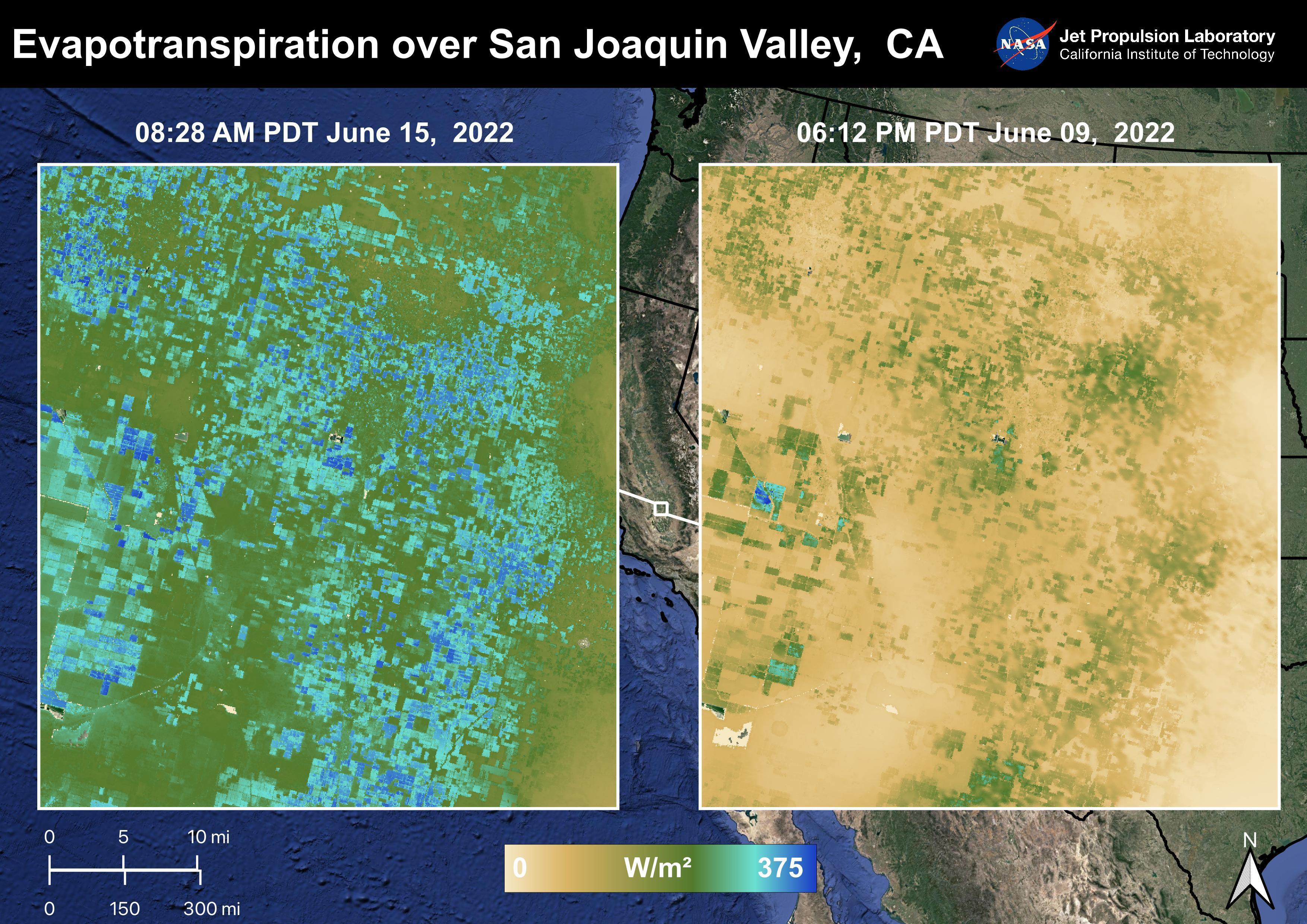
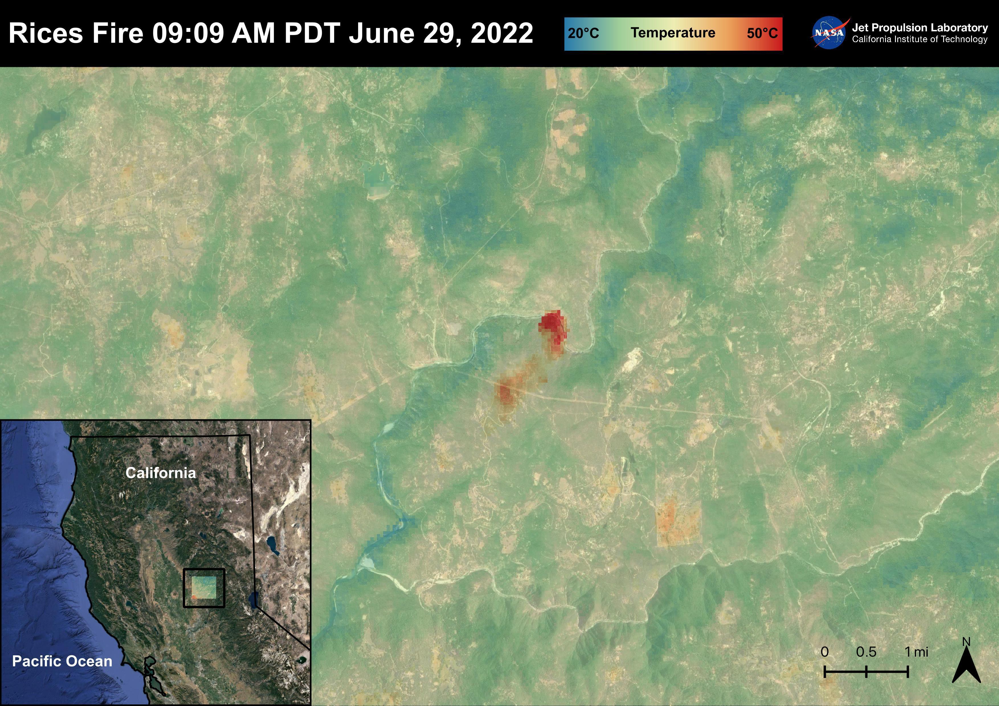
2022-08-04 |
Earth
|
ECOSTRESS
|
|
3507x2480x3 |
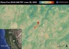
|
-
PIA25485:
-
The Rices Fire
Full Resolution:
TIFF
(23.34 MB)
JPEG
(1.067 MB)
|
|
|
2022-08-04 |
Earth
|
ECOSTRESS
|
|
3507x2480x3 |
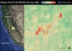
|
-
PIA25484:
-
The Electra Fire
Full Resolution:
TIFF
(23.43 MB)
JPEG
(1.034 MB)
|
|
|
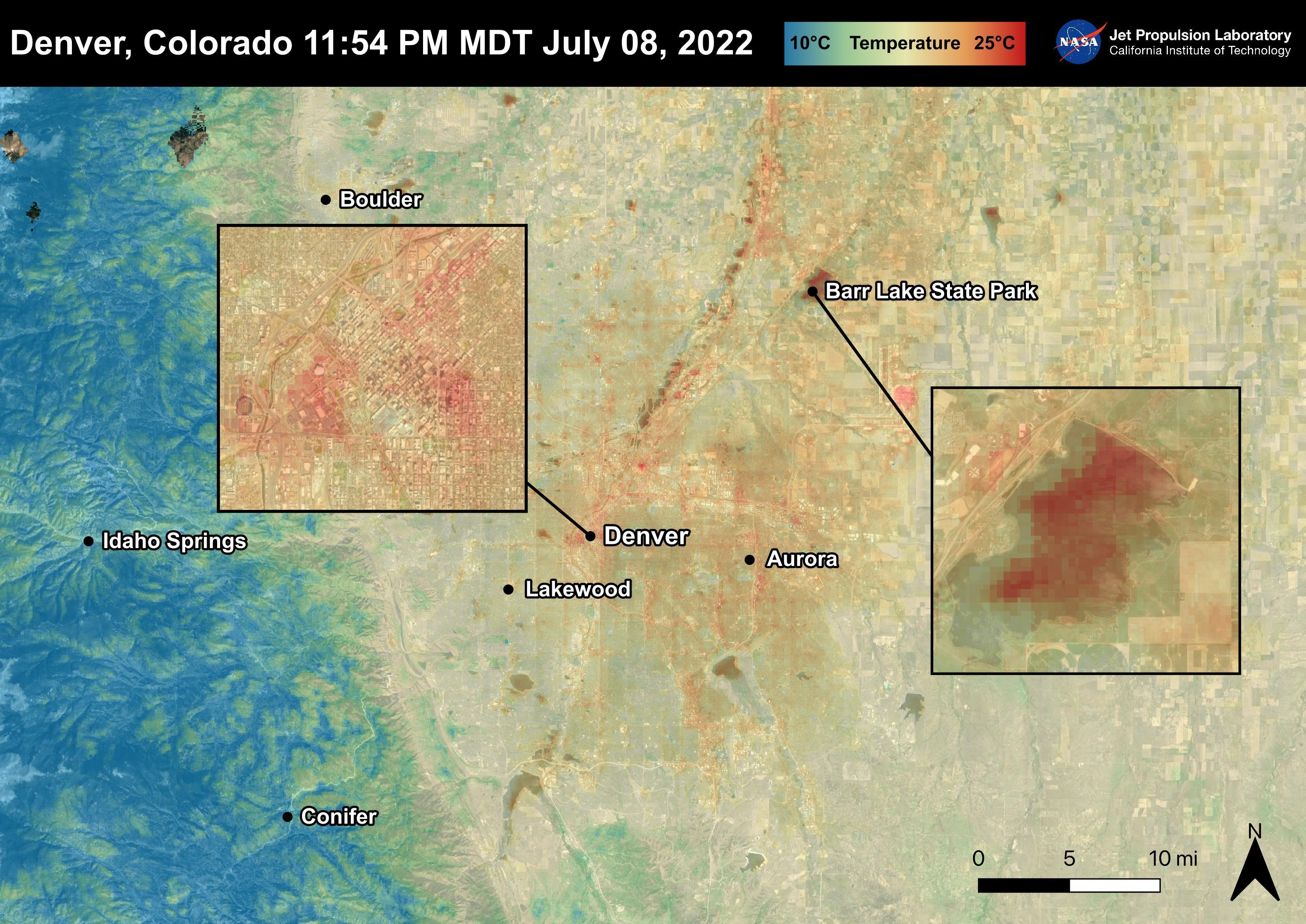
2022-08-04 |
Earth
|
ECOSTRESS
|
|
3507x2480x3 |
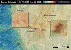
|
-
PIA25483:
-
Denver, CO
Full Resolution:
TIFF
(25.33 MB)
JPEG
(1.18 MB)
|
|
|
2022-08-04 |
Earth
|
ECOSTRESS
|
|
3507x2480x3 |
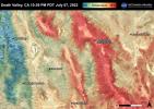
|
-
PIA25482:
-
Death Valley, CA
Full Resolution:
TIFF
(26.1 MB)
JPEG
(1.367 MB)
|
|
|
2022-08-04 |
Earth
|
ECOSTRESS
|
|
3507x2480x3 |
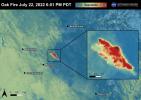
|
-
PIA25481:
-
The Oak Fire
Full Resolution:
TIFF
(21.67 MB)
JPEG
(865 kB)
|
|
|
2022-07-29 |
Earth
|
Earth Surface Mineral Dust Source Investigation (EMIT)
|
EMIT
|
1774x1458x3 |
|
-
PIA24529:
-
EMIT Instrument's First Light
Full Resolution:
TIFF
(7.334 MB)
JPEG
(508.6 kB)
|
|
|
2022-07-28 |
Earth
|
Terra
|
ASTER
|
2533x1508x3 |
|
-
PIA25445:
-
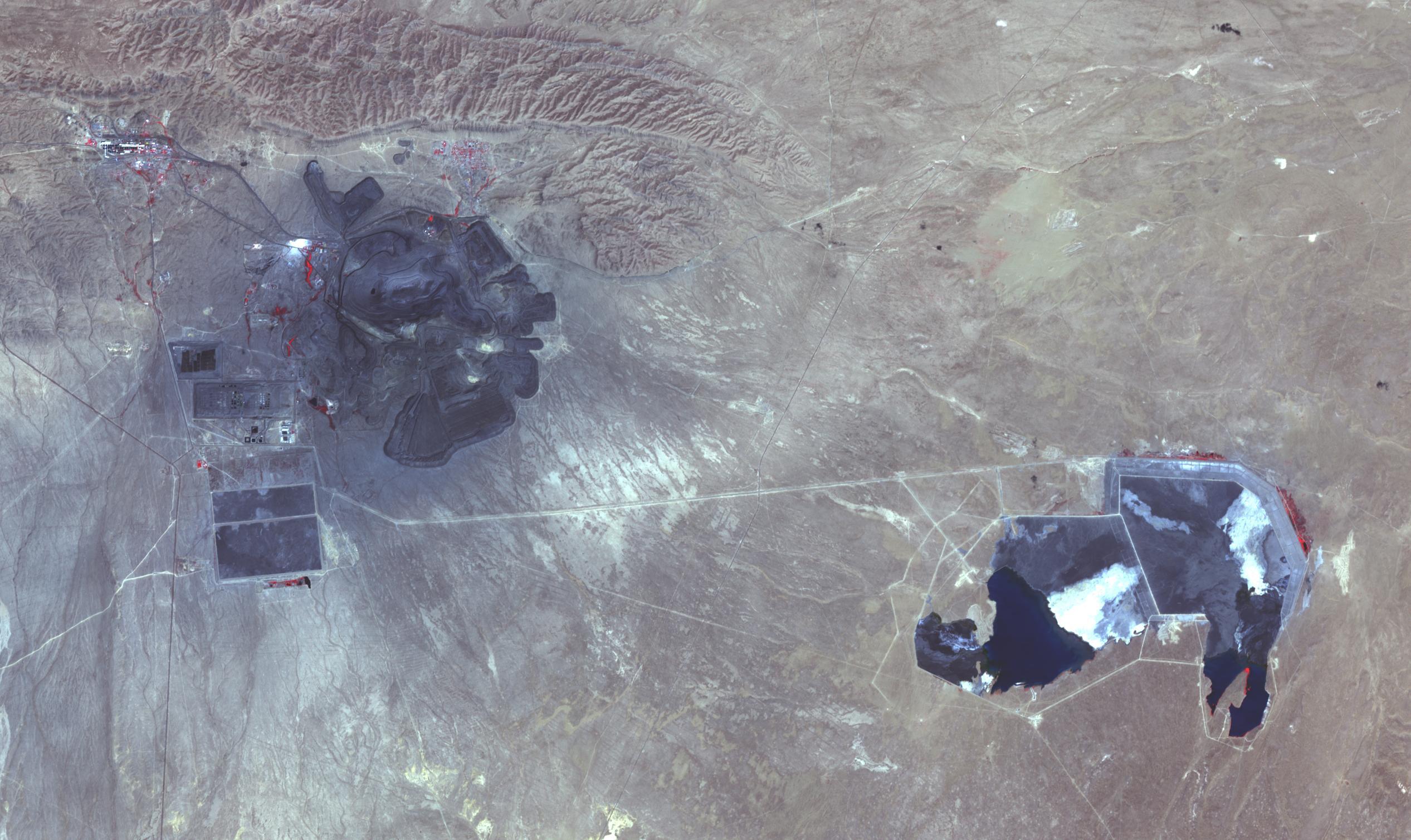
Muruntau Mine, Uzbekistan
Full Resolution:
TIFF
(10.17 MB)
JPEG
(502.4 kB)
|
|
|
2022-07-27 |
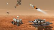
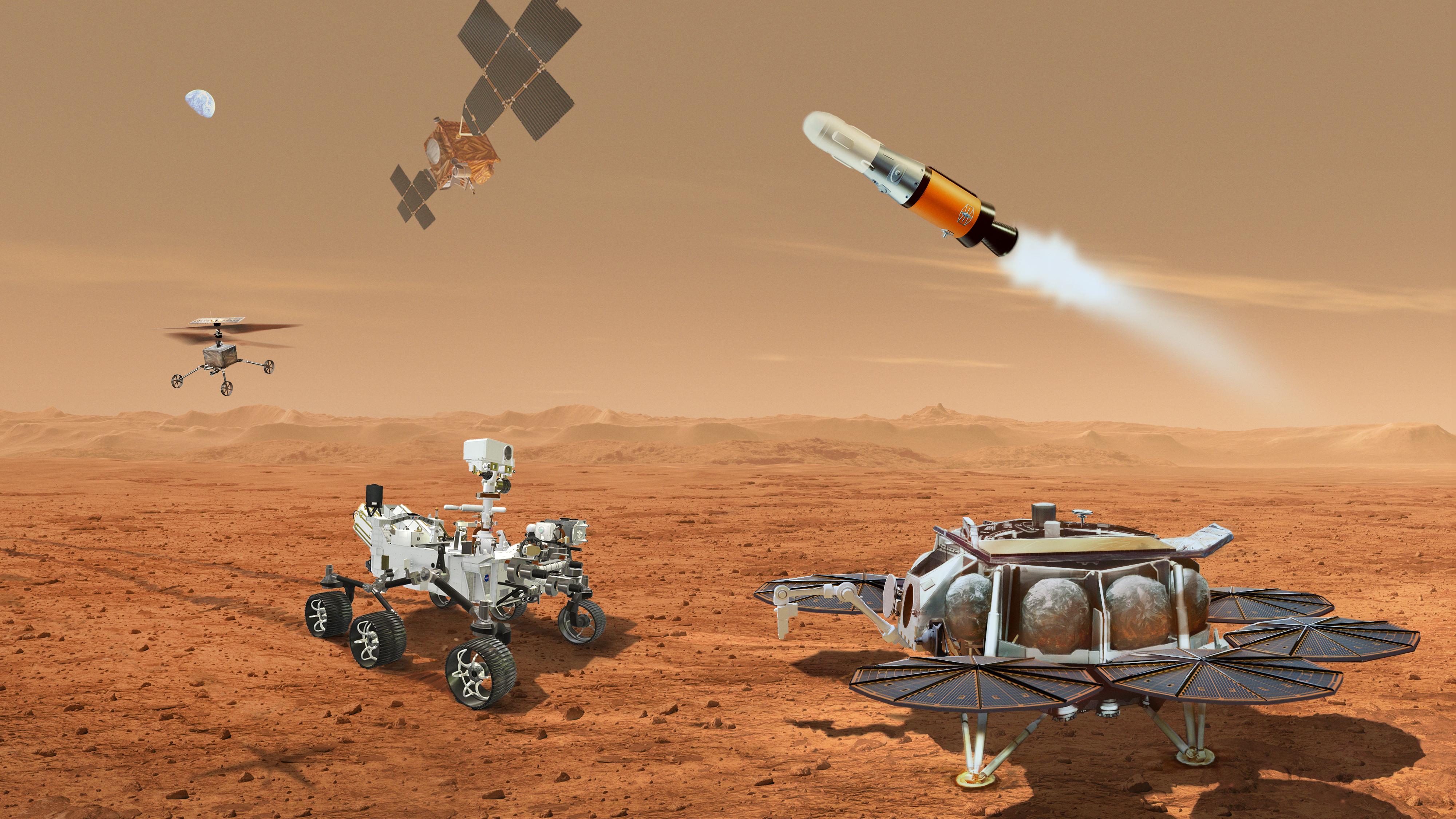
Mars
|
Mars Sample Return (MSR)
|
|
4000x2250x3 |
|
-
PIA25326:
-
Mars Sample Return Concept Illustration
Full Resolution:
TIFF
(26.57 MB)
JPEG
(1.091 MB)
|
|
|
2022-07-26 |
Earth
|
Terra
|
MISR
|
3500x1029x3 |
|
-
PIA24907:
-
MISR Images Oak Fire Near Yosemite
Full Resolution:
TIFF
(7.635 MB)
JPEG
(379.1 kB)
|
|
|
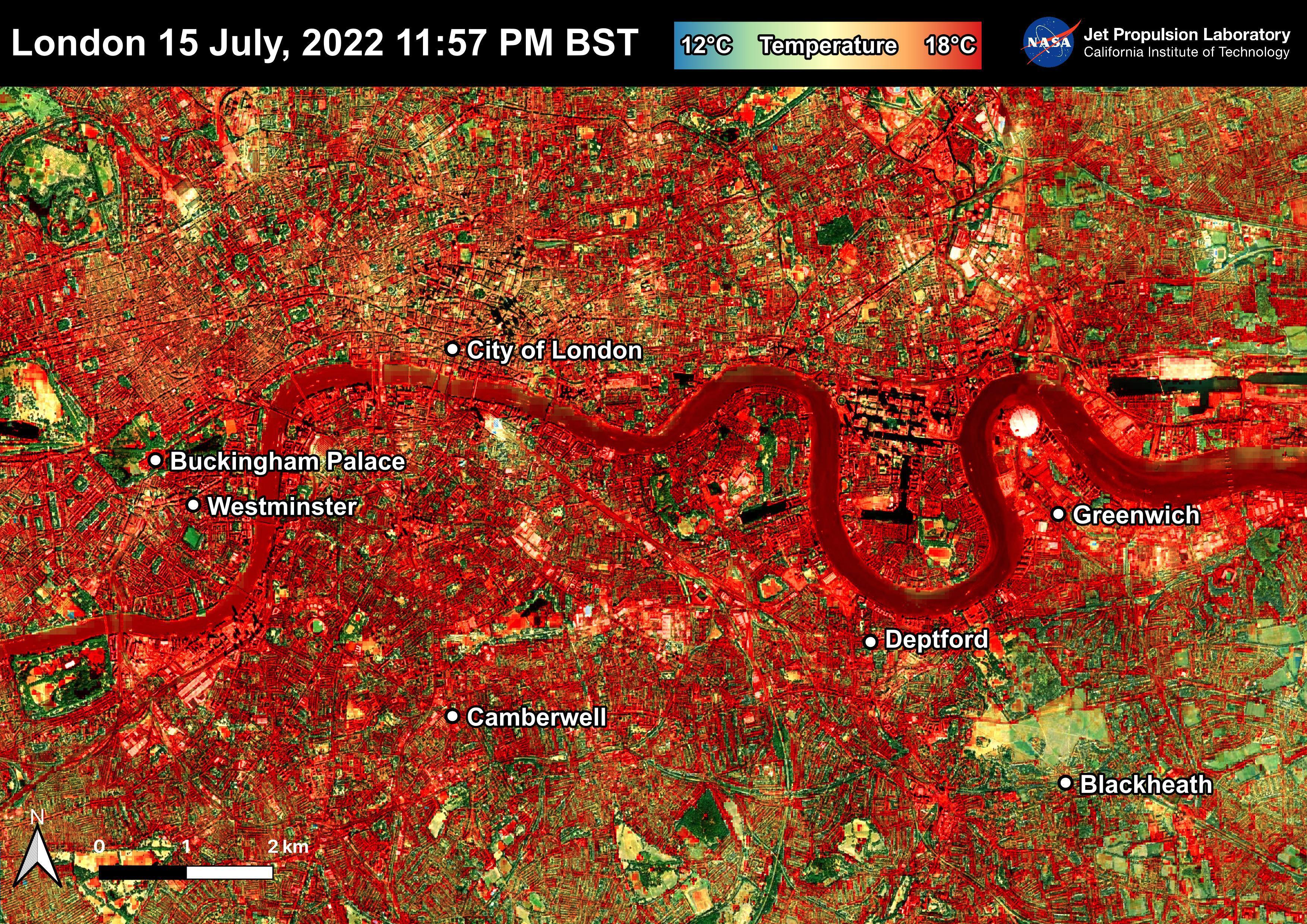
2022-07-22 |
Earth
|
ECOSTRESS
|
|
3507x2480x3 |
|
-
PIA25423:
-
NASA's ECOSTRESS Shows Overnight Heat in London
Full Resolution:
TIFF
(26.1 MB)
JPEG
(2.721 MB)
|
|
|
2022-07-22 |
Mars
|
Mars Reconnaissance Orbiter (MRO)
|
HiRISE
|
2880x1800x3 |
|
-
PIA25449:
-
Marvelous Martian Mega-Ripples
Full Resolution:
TIFF
(15.56 MB)
JPEG
(1.219 MB)
|
|
|
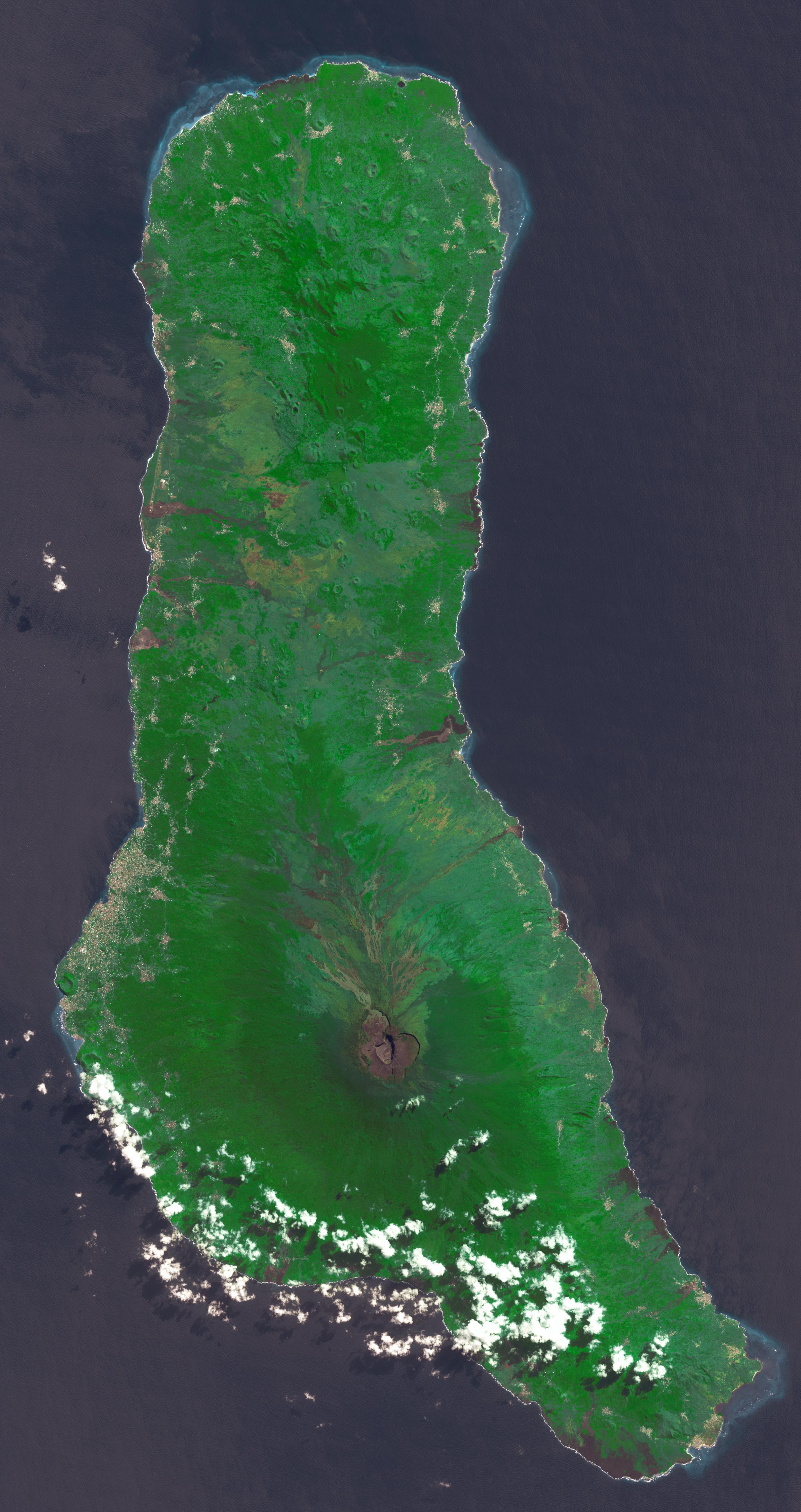
2022-07-21 |
Earth
|
Terra
|
ASTER
|
2382x4495x3 |

|
-
PIA25444:
-
Union of the Comoros
Full Resolution:
TIFF
(26.03 MB)
JPEG
(1.164 MB)
|
|
|
2022-07-19 |
|
Mars Sample Return (MSR)
|
|
3840x2160x3 |

|
-
PIA25443:
-
First Meeting of Mars Sample Return Campaign Science Group
Full Resolution:
TIFF
(21.44 MB)
JPEG
(752.4 kB)
|
|
|
2022-07-19 |
|
Mars Sample Return (MSR)
|
|
4240x2832x3 |

|
-
PIA25442:
-
Mars Sample Return Campaign Science Group Team Photo
Full Resolution:
TIFF
(31.12 MB)
JPEG
(1.29 MB)
|
|
|
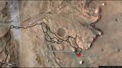
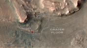
2022-07-11 |
Mars
|
Mars 2020 Rover
|
Navigation Camera (M2020)
|
16287x4459x3 |
|
-
PIA25406:
Perseverance's Panorama of Potential Mars Sample Return Landing Site
Full Resolution:
TIFF
(131.2 MB)
JPEG
(5.311 MB)
|
|
|
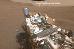
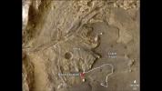
2022-07-11 |
Mars
|
Mars 2020 Rover
|
Navigation Camera (M2020)
|
5120x3840x3 |
|
-
PIA25370:
-
Perseverance Scouts Landing Sites for Mars Sample Return Campaign
Full Resolution:
TIFF
(59.01 MB)
JPEG
(3.648 MB)
|
|
|
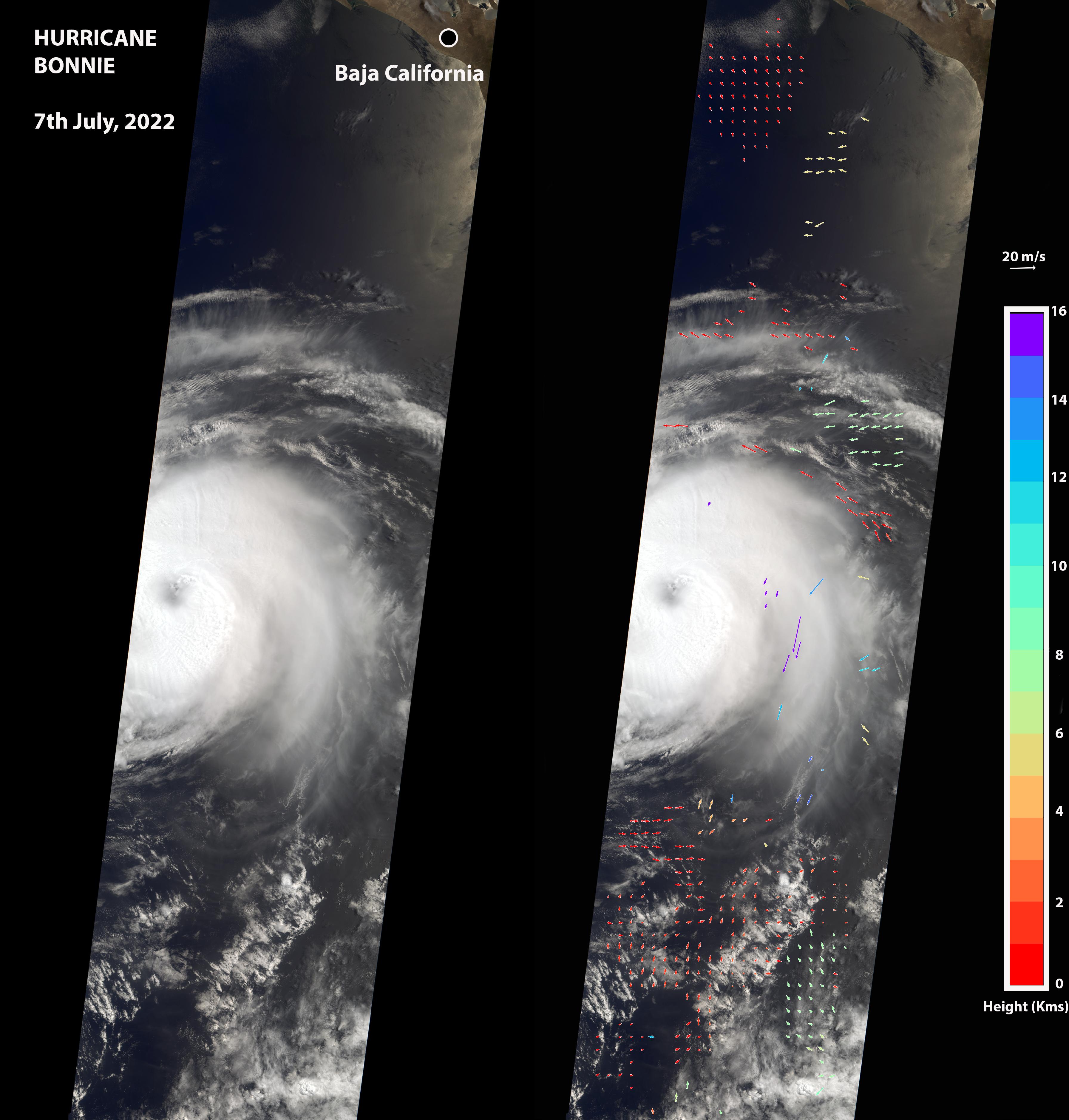
2022-07-08 |
Earth
|
Terra
|
MISR
|
3584x3754x3 |
|
-
PIA24906:
-
NASA's MISR Captures Hurricane Bonnie
Full Resolution:
TIFF
(16.61 MB)
JPEG
(877 kB)
|
|
|
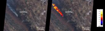
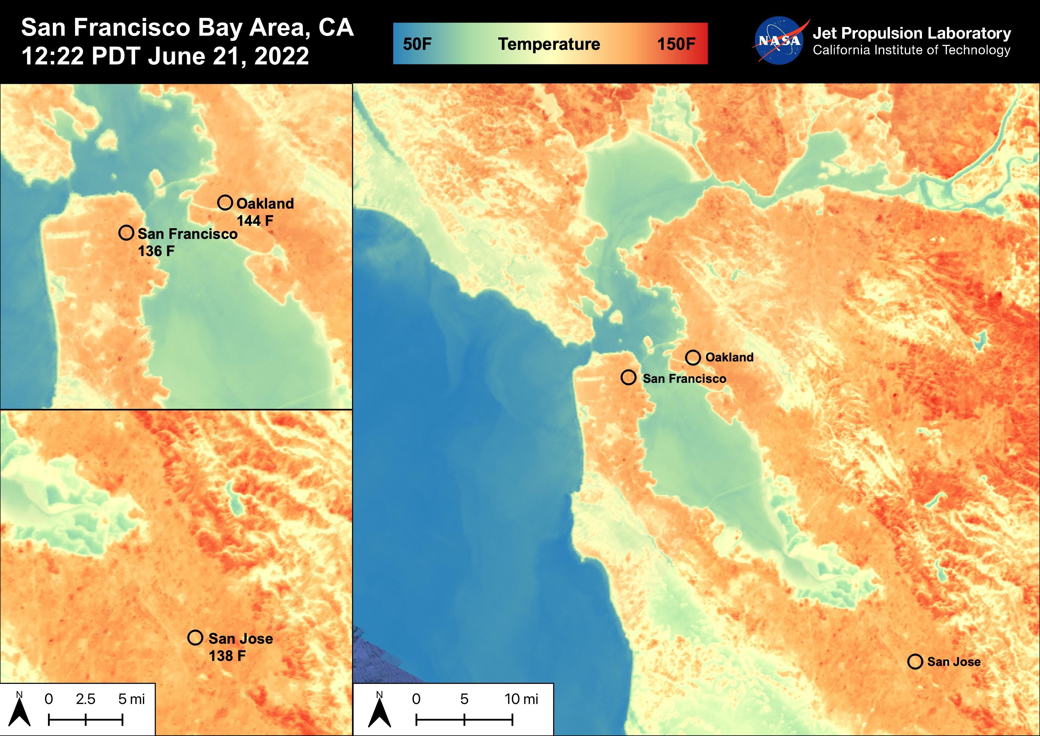
2022-06-30 |
Earth
|
ECOSTRESS
|
|
3507x2480x3 |
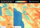
|
-
PIA25441:
-
High Temperatures in the San Francisco Bay Area
Full Resolution:
TIFF
(21.01 MB)
JPEG
(919.1 kB)
|
|
|
2022-06-30 |
Earth
|
ECOSTRESS
|
|
3507x2480x3 |
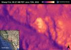
|
-
PIA25356:
-
Sheep Fire
Full Resolution:
TIFF
(16.45 MB)
JPEG
(598.1 kB)
|
|
|
2022-06-30 |
Earth
|
ECOSTRESS
|
|
3507x2480x3 |
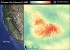
|
-
PIA25280:
-
Colorado Fire
Full Resolution:
TIFF
(17.17 MB)
JPEG
(810.7 kB)
|
|
|
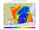
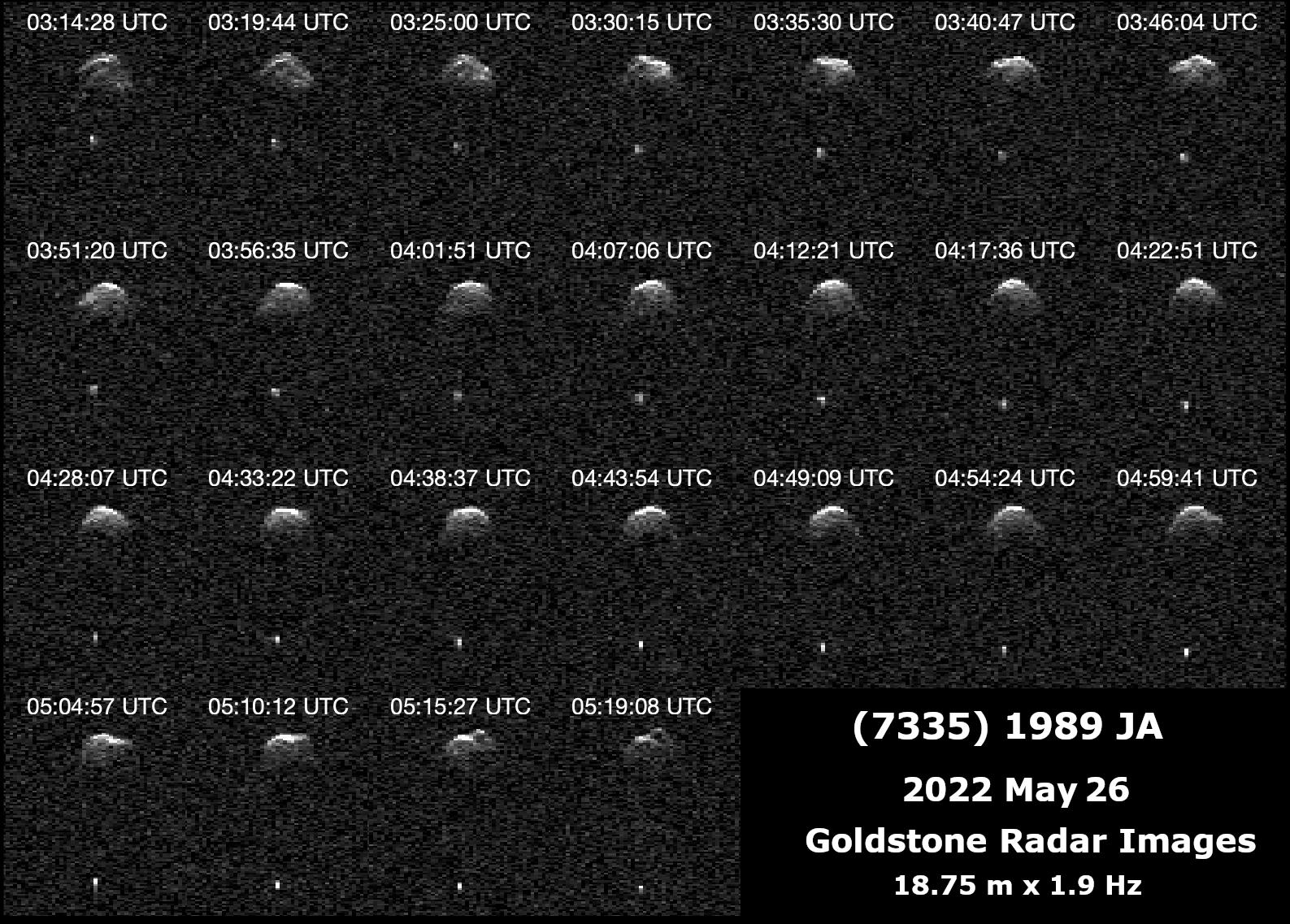
2022-06-29 |
Asteroid
|
Deep Space Network (DSN)
|
Deep Space Network
|
1587x1137x1 |
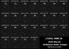
|
-
PIA25251:
-
Radar Observations of Near-Earth Asteroid 7335 1989 JA
Full Resolution:
TIFF
(972.3 kB)
JPEG
(398.1 kB)
|
|
|
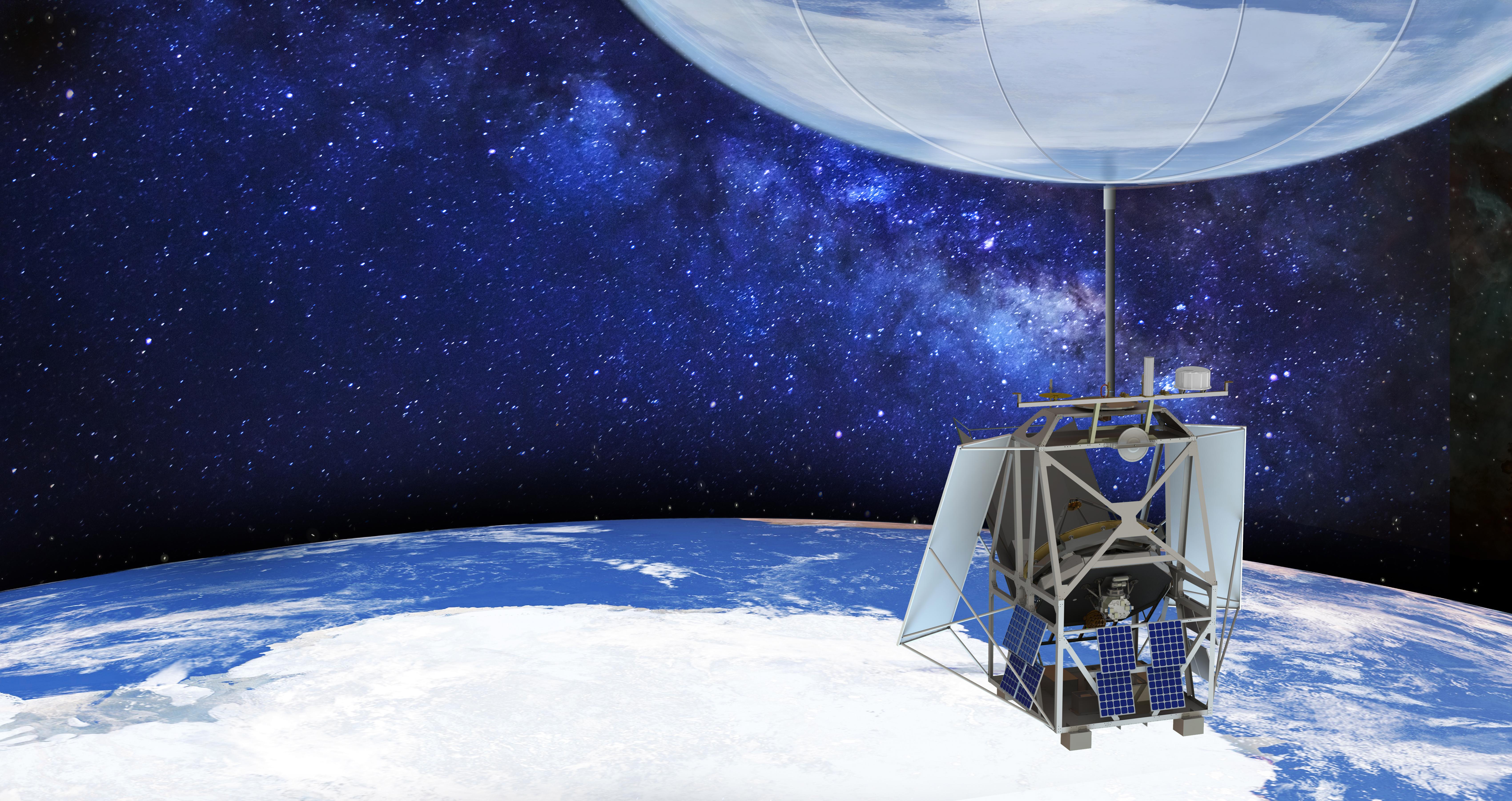
2022-06-29 |
|
ASTHROS
|
ASTHROS
|
6800x3600x3 |

|
-
PIA25168:
-
ASTHROS Mission in Flight (Illustration)
Full Resolution:
TIFF
(56.93 MB)
JPEG
(2.325 MB)
|
|
|
2022-06-29 |
Mars
|
Mars 2020 Rover
|
Hazard Avoidance Camera (M2020)
|
5120x2880x3 |
|
-
PIA25325:
-
Enchanted View of Jezero Rocks
Full Resolution:
TIFF
(42.08 MB)
JPEG
(1.897 MB)
|
|
|
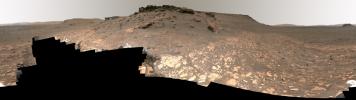
2022-06-28 |
Mars
|
2001 Mars Odyssey
|
THEMIS
|
673x1416x1 |
|
-
PIA25392:
-
Oti Fossae - Arsia Mons
Full Resolution:
TIFF
(697.7 kB)
JPEG
(103.3 kB)
|
|
|
2022-06-27 |
Earth
|
Terra
|
ASTER
|
1101x1054x3 |
|
-
PIA25355:
-
Lake Shuwarang Chhat, Pakistan
Full Resolution:
TIFF
(3.483 MB)
JPEG
(232.6 kB)
|
|
|
2022-06-22 |
Earth
|
ECOSTRESS
|
|
3099x2201x3 |
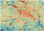
|
-
PIA25422:
-
NASA's ECOSTRESS Shows Heat in Dallas and Fort Worth
Full Resolution:
TIFF
(20.47 MB)
JPEG
(2.22 MB)
|
|
|
2022-06-22 |
Earth
|
ECOSTRESS
|
|
3161x2230x3 |
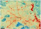
|
-
PIA25421:
-
NASA's ECOSTRESS Shows Surface Heat in Houston
Full Resolution:
TIFF
(21.16 MB)
JPEG
(1.711 MB)
|
|
|
2022-06-22 |
Mars
|
Mars Science Laboratory (MSL)
|
Mastcam
|
6325x2726x3 |
|
-
PIA25367:
-
Curiosity's View of Sulfate-Bearing Region and Streambed Rocks
Full Resolution:
TIFF
(30.63 MB)
JPEG
(2.614 MB)
|
|
|
2022-06-22 |
Mars
|
Mars Science Laboratory (MSL)
|
Mastcam
|
17708x5681x3 |
|
-
PIA25365:
-
Curiosity's View of Haze During Dust Season
Full Resolution:
TIFF
(166.9 MB)
JPEG
(11.07 MB)
|
|
|
2022-06-15 |
Earth
|
ECOSTRESS
|
|
2304x1296x3 |

|
-
PIA24988:
-
NASA's ECOSTRESS Sees Las Vegas Streets Turn Up the Heat
Full Resolution:
TIFF
(8.962 MB)
JPEG
(479.4 kB)
|
|
|
2022-06-14 |
|
|
|
7485x4990x3 |

|
-
PIA25312:
-
Chris Evans Visits JPL, Perseverance Model
Full Resolution:
TIFF
(97.13 MB)
JPEG
(5.204 MB)
|
|
|
2022-06-07 |
Europa
|
Europa Clipper
|
|
8192x5464x3 |
|
-
PIA25239:
-
Europa Clipper: Rolling Into NASA's Jet Propulsion Laboratory
Full Resolution:
TIFF
(102.4 MB)
JPEG
(15.12 MB)
|
|
|
2022-06-07 |
Europa
|
Europa Clipper
|
|
8192x5464x3 |
|
-
PIA25238:
-
NASA's Europa Clipper Arrives in Southern California
Full Resolution:
TIFF
(120 MB)
JPEG
(7.298 MB)
|
|
|
2022-06-07 |
Europa
|
Europa Clipper
|
|
3300x2201x3 |
|
-
PIA25237:
-
Revealing Europa Clipper's Core
Full Resolution:
TIFF
(18.52 MB)
JPEG
(1.033 MB)
|
|
|
2022-06-07 |
Europa
|
Europa Clipper
|
|
3300x2201x3 |
|
-
PIA25236:
-
Europa Clipper's Core
Full Resolution:
TIFF
(16.81 MB)
JPEG
(979.9 kB)
|
|
|
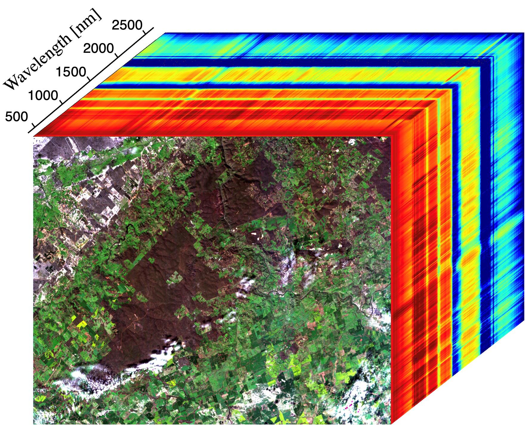
2022-06-01 |
Earth
|
Earth Surface Mineral Dust Source Investigation (EMIT)
|
EMIT
|
5568x3712x3 |

|
-
PIA25150:
-
EMIT Put to the Test at JPL
Full Resolution:
TIFF
(43.37 MB)
JPEG
(1.852 MB)
|
 Planetary Data System


