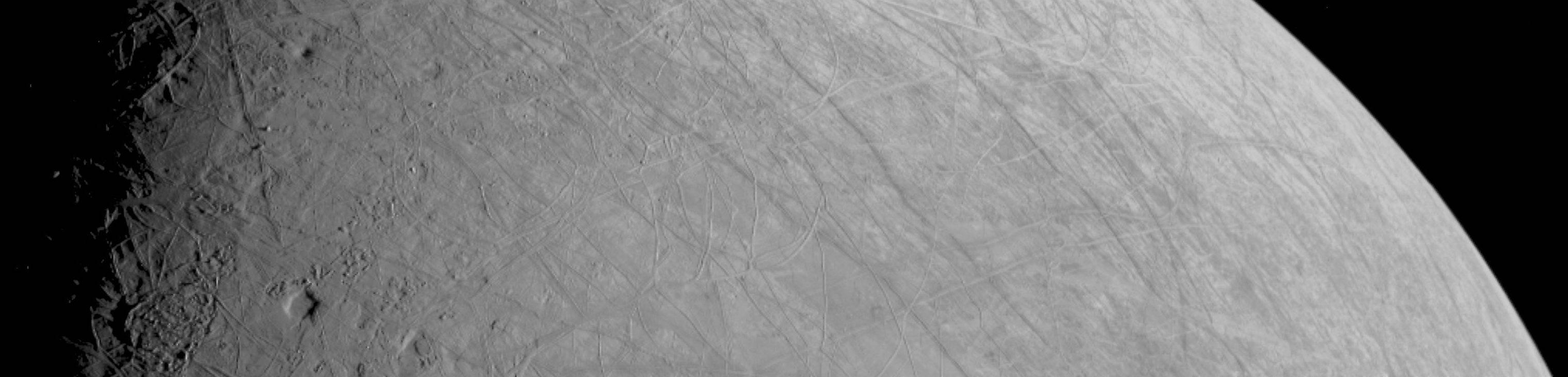
This look at the complex, ice-covered surface of Jupiter's moon Europa came from NASA's Juno mission during a close pass on Sept. 29, 2022. At closest approach, the spacecraft came within a distance of about 219 miles (352 kilometers). Juno's flyby is only the third close pass of the moon in history and the closest look any spacecraft has provided of Europa since Jan. 3, 2000, when NASA's Galileo came within 218 miles (351 kilometers) of the surface.
Europa is the sixth-largest moon in the solar system, slightly smaller than Earth's moon. Scientists think a salty ocean lies below a miles-thick ice shell.
This segment of the first image of Europa taken during this flyby by the spacecraft's JunoCam (a public-engagement camera) zooms in on a swath of Europa's surface north of the equator. Due to the enhanced contrast between light and shadow seen along the terminator (the nightside boundary, at 10 degrees west longitude), rugged terrain features are easily seen, including tall shadow-casting blocks, while bright and dark ridges and troughs curve across the surface. The oblong pit near the terminator might be a degraded impact crater. The vertical area covered in the image is 155 miles (250 kilometers) tall. The resolution of the image is 0.6 miles (1 kilometer) per pixel.
JunoCam's raw images are available for the public to peruse and process into image products at https://missionjuno.swri.edu/junocam/processing. More information about NASA citizen science can be found at https://science.nasa.gov/citizenscience and https://www.nasa.gov/solve/opportunities/citizenscience.
More information about Juno is at https://www.nasa.gov/juno and https://missionjuno.swri.edu. For more about this finding and other science results, see https://www.missionjuno.swri.edu/science-findings.
NASA's Jet Propulsion Laboratory manages the Juno mission for the principal investigator, Scott Bolton, of Southwest Research Institute in San Antonio. Juno is part of NASA's New Frontiers Program, which is managed at NASA's Marshall Space Flight Center in Huntsville, Alabama, for NASA's Science Mission Directorate. Lockheed Martin Space Systems, Denver, built the spacecraft. Caltech in Pasadena, California, manages JPL for NASA.
 Planetary Data System


