My
List |
Addition Date
|
Target
|
Mission
|
Instrument
|
Size
|

|
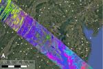
2025-06-06 |
Earth
|
|
SAR
|
1920x985x3 |

|
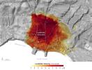
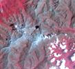
-
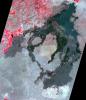
PIA26494:
-
NASA Portal Details Land Motion Across North America
Full Resolution:
TIFF
(2.941 MB)
JPEG
(184.7 kB)
|
|
|
2025-06-06 |
Mars
|
2001 Mars Odyssey
|
THEMIS
|
6400x1280x3 |

|
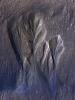
-
PIA26557:
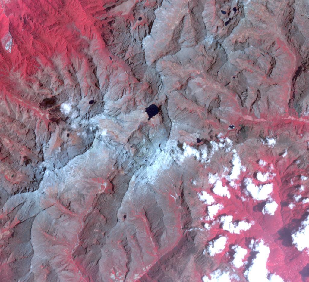
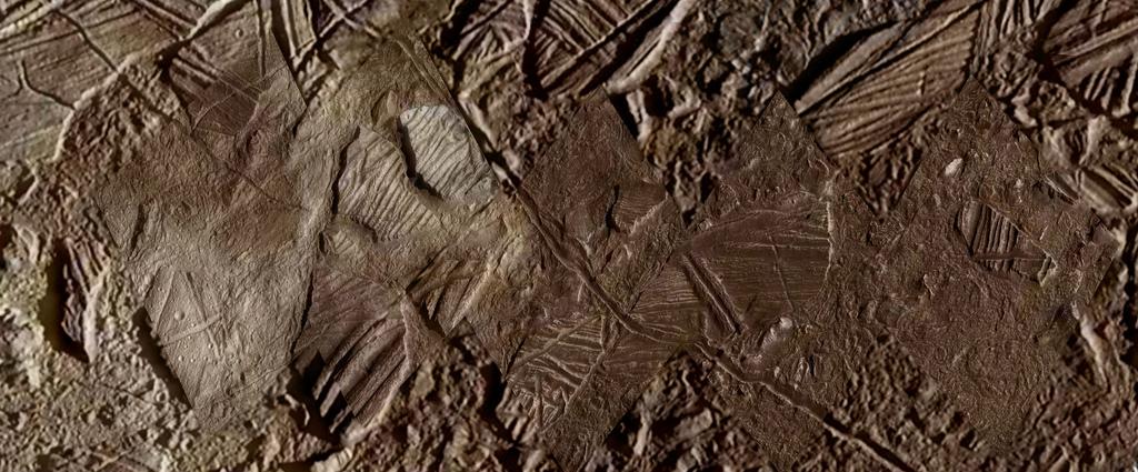
THEMIS Views Mars' Arsia Mons Volcano
Full Resolution:
TIFF
(17.93 MB)
JPEG
(623.2 kB)
|
|
|
2025-05-30 |
Earth
|
Terra
|
ASTER
|
1157x924x3 |

|
-
PIA26622:
-
Magee Marsh Wildlife Area, Ohio
Full Resolution:
TIFF
(3.208 MB)
JPEG
(172.1 kB)
|
|
|
2025-05-21 |
Mars
|
Mars 2020 Rover
|
Scanning Habitable Environments with Raman & Luminescence for Organics and Chemicals (SHERLOC)
|
12033x7168x3 |

|
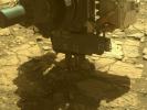
-
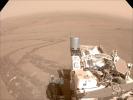
PIA26574:
-
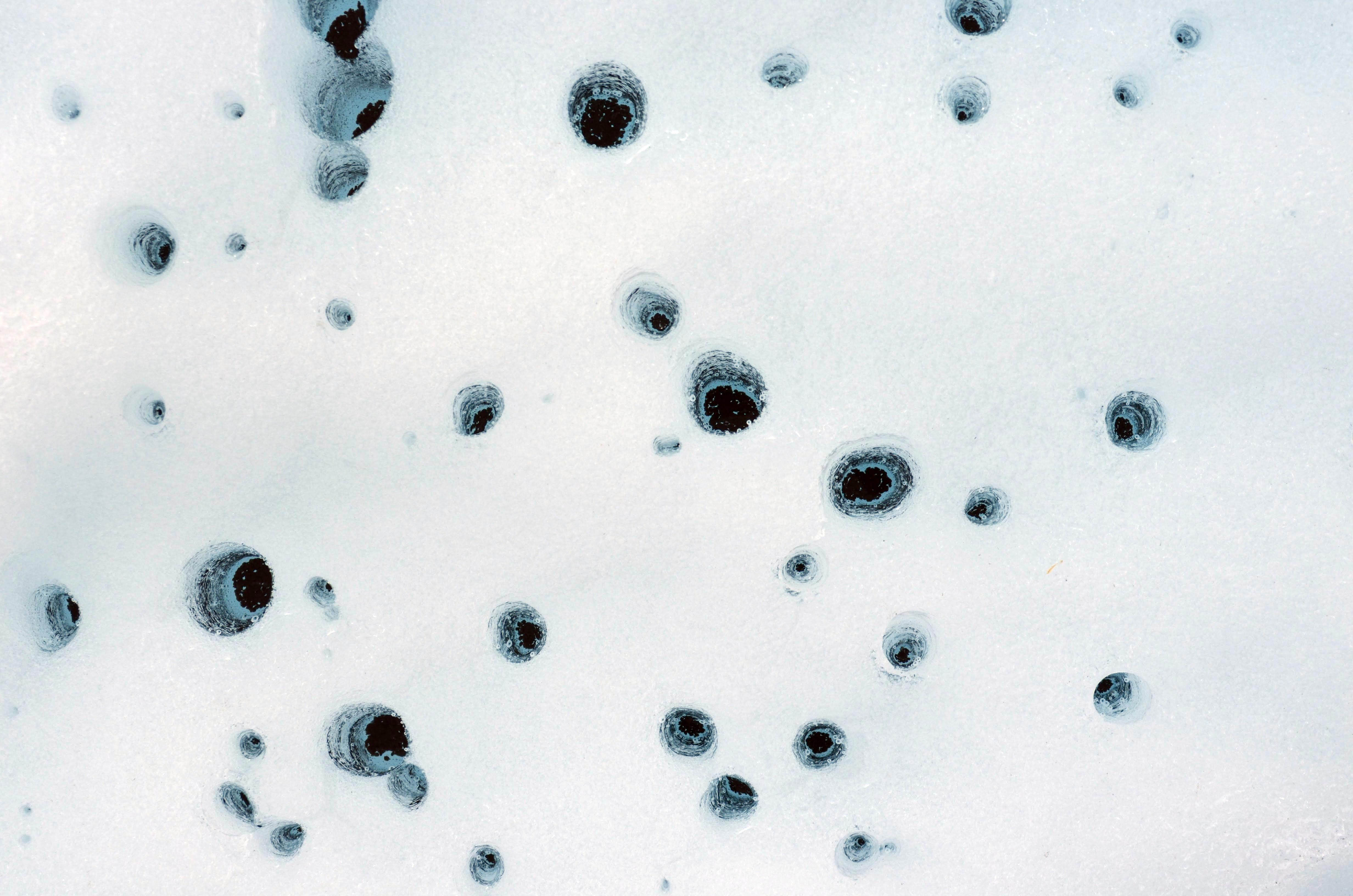
Dust Devil Photobombs Perseverance's Selfie
Full Resolution:
TIFF
(222.8 MB)
JPEG
(8.381 MB)
|
|
|
2025-05-15 |
Deimos
|
Mars 2020 Rover
|
Navigation Camera (M2020)
|
5120x3840x3 |

|
-
PIA26556:
-
Perseverance Views Deimos Before Sunrise
Full Resolution:
TIFF
(59.01 MB)
JPEG
(8.759 MB)
|
|
|
2025-05-12 |
Earth
|
Terra
|
ASTER
|
1289x833x3 |

|
-
PIA26621:
-
Mackinac Island, Michigan
Full Resolution:
TIFF
(1.651 MB)
JPEG
(69.86 kB)
|
|
|
2025-04-29 |
Earth
|
Terra
|
ASTER
|
1222x1096x3 |

|
-
PIA26510:
-
Hutt Lagoon, Australia
Full Resolution:
TIFF
(3.908 MB)
JPEG
(216.6 kB)
|
|
|
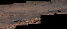
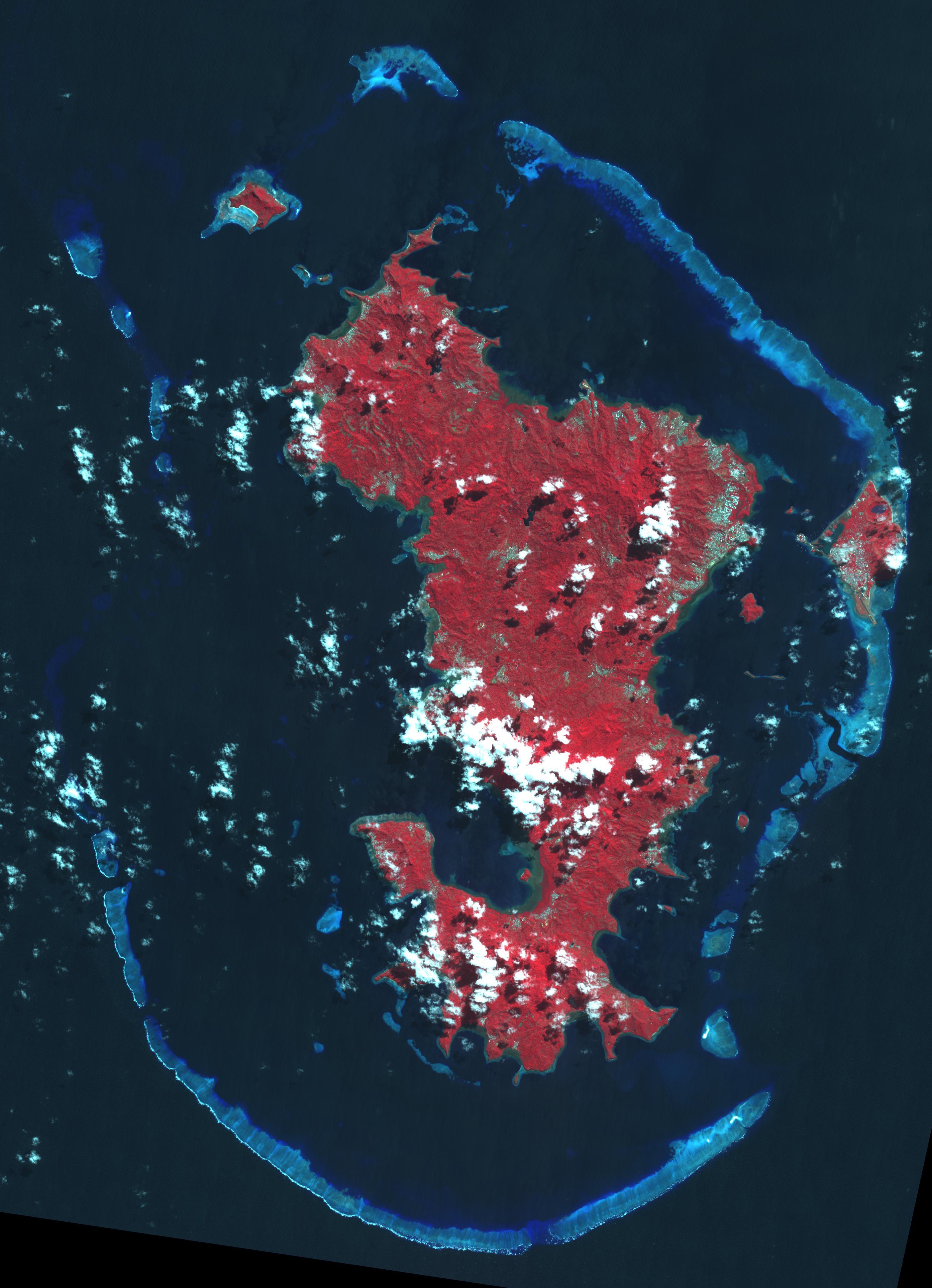
2025-04-24 |
Mars
|
Mars Science Laboratory (MSL)
|
Mastcam
|
19506x3191x3 |

|
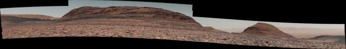
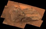
-
PIA26551:
Curiosity Looks Downslope From the Sulfate Unit
Full Resolution:
TIFF
(151 MB)
JPEG
(10.7 MB)
|
|
|
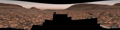
2025-04-24 |
Mars
|
Mars Science Laboratory (MSL)
|
Mastcam
|
39948x4084x3 |

|
-
PIA26552:
Curiosity on the Road to Boxwork Formations
Full Resolution:
TIFF
(410 MB)
JPEG
(33.77 MB)
|
|
|
2025-04-23 |
Earth
|
|
AVIRIS-3
|
1440x600x3 |

|
-
PIA26499:
-
AVIRIS-3 Sensor Captures Data on Wildfire Near Mount Vernon, Alabama
Full Resolution:
TIFF
(2.518 MB)
JPEG
(173 kB)
|
|
|
2025-04-23 |
Earth
|
|
AVIRIS-3
|
1440x600x3 |

|
-
PIA26498:
-
AVIRIS-3 Sensor Captures Data on Wildfire Near Perdido, Alabama
Full Resolution:
TIFF
(2.497 MB)
JPEG
(175.8 kB)
|
|
|
2025-04-23 |
Earth
|
|
AVIRIS-3
|
1920x1080x3 |

|
-
PIA26497:
-
AVIRIS-3 Sensor Captures Data on Wildfire Near Castleberry, Alabama
Full Resolution:
TIFF
(6.223 MB)
JPEG
(393 kB)
|
|
|
2025-04-17 |
Mars
|
Mars Science Laboratory (MSL)
|
Mastcam
|
29163x7446x3 |

|
-
PIA26554:
Curiosity Surveys the 'Ubajara' Sampling Site on Mars
Full Resolution:
TIFF
(482.5 MB)
JPEG
(43.1 MB)
|
|
|
2025-04-10 |
Mars
|
Mars 2020 Rover
|
Mastcam-Z
|
1648x1200x3 |

|
-
PIA26529:
-
'Green Gardens' Sample in Tube
Full Resolution:
TIFF
(5.134 MB)
JPEG
(109.1 kB)
|
|
|
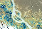
2025-04-10 |
Mars
|
Mars 2020 Rover
|
Hazard Avoidance Camera (M2020)
|
978x733x3 |
|
-
PIA26571:
-
Perseverance Cores 'Main River'
Full Resolution:
TIFF
(1.993 MB)
JPEG
(103 kB)
|
|
|
2025-04-10 |
Mars
|
Mars 2020 Rover
|
Mastcam-Z
|
34516x4932x3 |

|
-
PIA26530:
Christmas at Crater Rim
Full Resolution:
TIFF
(389.1 MB)
JPEG
(24.18 MB)
|
|
|
2025-04-07 |
Earth
|
Terra
|
ASTER
|
2358x2315x3 |

|
-
PIA26509:
-
Heard Volcano, Australia
Full Resolution:
TIFF
(12.73 MB)
JPEG
(471.7 kB)
|
|
|
2025-04-03 |
Mars
|
Mars 2020 Rover
|
Navigation Camera (M2020)
|
1276x237x3 |
|
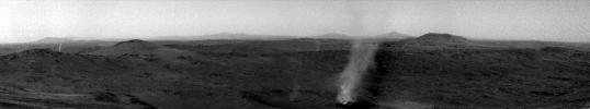
-
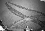
PIA26528:
Perserverance Captures Crater Rim Dust Devil Eating Its Own
Full Resolution:
TIFF
(303 kB)
JPEG
(48.58 kB)
|
|
|
2025-04-01 |
Sky
|
SPHEREx
|
Spectro-Photometer
|
2708x1754x3 |
|
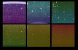
-
PIA26280:
-
First Images From NASA's SPHEREx
Full Resolution:
TIFF
(6.303 MB)
JPEG
(1.066 MB)
|
|
|
2025-03-26 |
Mars
|
Mars 2020 Rover
|
Scanning Habitable Environments with Raman & Luminescence for Organics and Chemicals (SHERLOC)
|
3264x1480x3 |
|
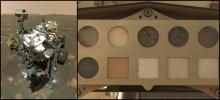
-
PIA26520:
-
Perseverance and SHERLOC's Calibration Target
Full Resolution:
TIFF
(11.87 MB)
JPEG
(449.9 kB)
|
|
|
2025-03-24 |
Earth
|
Terra
|
ASTER
|
534x506x3 |

|
-
PIA26508:
-
JFK Memorial, Runnymede Meadow, England
Full Resolution:
TIFF
(811.1 kB)
JPEG
(64.29 kB)
|
|
|
2025-03-12 |
|
NEO Surveyor
|
|
11173x8380x3 |

|
-
PIA26583:
-
NEO Surveyor Instrument Enclosure Inside Historic Chamber A
Full Resolution:
TIFF
(129.2 MB)
JPEG
(4.338 MB)
|
|
|
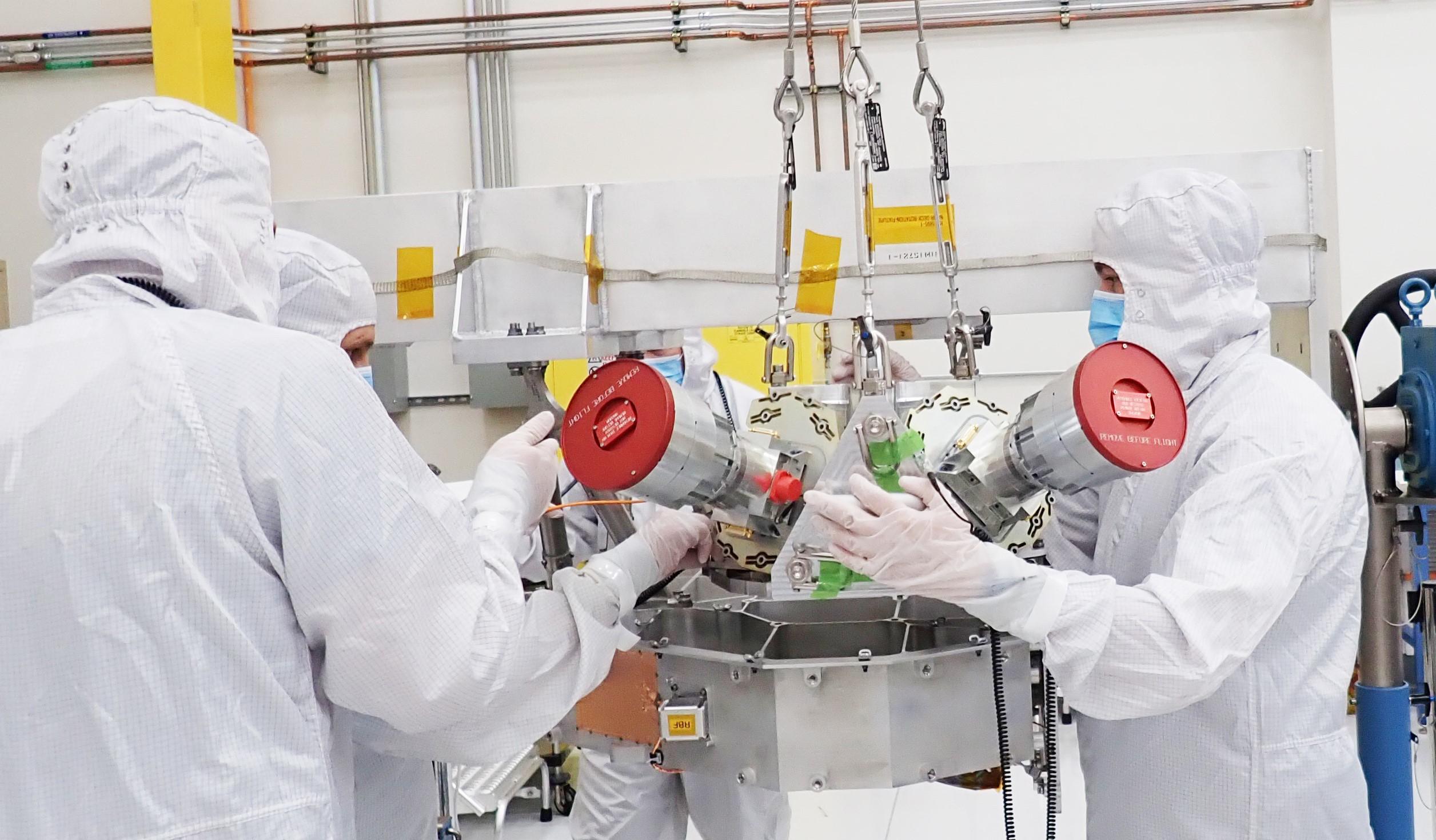
2025-03-12 |
|
NEO Surveyor
|
|
2400x1799x3 |

|
-
PIA26582:
-
NEO Surveyor Instrument Enclosure Begins Environmental Tests
Full Resolution:
TIFF
(9.504 MB)
JPEG
(414.4 kB)
|
|
|
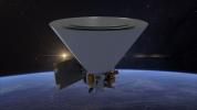
2025-03-12 |
|
NISAR
|
|
2558x937x3 |

|
-
PIA26496:
-
NISAR in Orbit Over Northeastern India (Artist's Concept)
Full Resolution:
TIFF
(5.843 MB)
JPEG
(265.6 kB)
|
|
|
2025-03-11 |
Earth
|
Terra
|
ASTER
|
1206x1240x3 |

|
-
PIA26507:
-
Charleston, SC
Full Resolution:
TIFF
(4.488 MB)
JPEG
(333.9 kB)
|
|
|
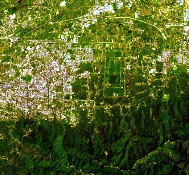
2025-02-24 |
Earth
|
Terra
|
ASTER
|
2202x6214x3 |

|
-
PIA26506:
-
Taal Volcano, Philippines
Full Resolution:
TIFF
(38.24 MB)
JPEG
(1.914 MB)
|
|
|
2025-02-11 |
Earth
|
Terra
|
ASTER
|
1435x1918x3 |

|
-
PIA26505:
-
Clayton Valley, NV
Full Resolution:
TIFF
(7.679 MB)
JPEG
(378.5 kB)
|
|
|
2025-02-11 |
|
Cooperative Autonomous Distributed Robotic Exploration (CADRE)
|
|
3840x2160x3 |

|
-
PIA26428:
-
CADRE Rover Awaits Shipping
Full Resolution:
TIFF
(19.19 MB)
JPEG
(595.6 kB)
|
|
|
2025-02-11 |
|
Cooperative Autonomous Distributed Robotic Exploration (CADRE)
|
|
11600x8700x3 |

|
-
PIA26427:
-
Taking a CADRE Rover in Hand
Full Resolution:
TIFF
(255.4 MB)
JPEG
(8.701 MB)
|
|
|
2025-02-11 |
|
Cooperative Autonomous Distributed Robotic Exploration (CADRE)
|
|
3840x2160x3 |

|
-
PIA26426:
-
Packing Up a CADRE Rover
Full Resolution:
TIFF
(19.74 MB)
JPEG
(691.2 kB)
|
|
|
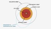
2025-02-04 |
|
Europa Clipper
|
|
2512x1470x3 |

|
-
PIA26562:
-
Star Trackers for Europa Clipper
Full Resolution:
TIFF
(8.704 MB)
JPEG
(359.6 kB)
|
|
|
2025-01-31 |
Earth
|
|
UAVSAR
|
1440x1090x3 |
|
-
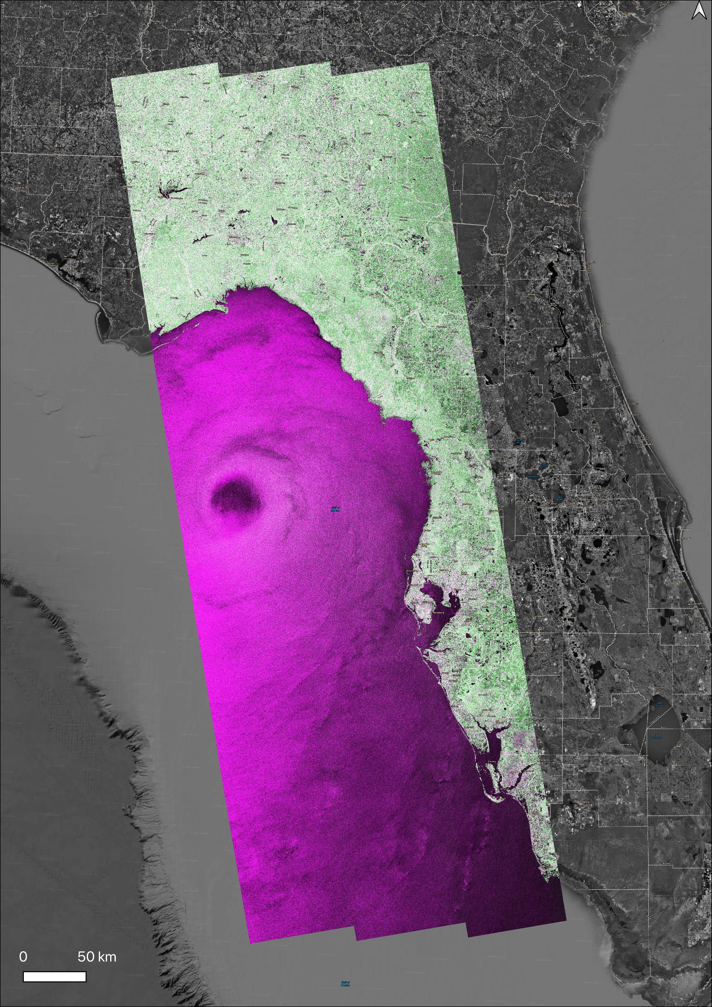
PIA26495:
-
NASA Radar Looks at Palos Verdes Landslides
Full Resolution:
TIFF
(2.762 MB)
JPEG
(259.6 kB)
|
|
|
2025-01-30 |
Earth
|
Terra
|
ASTER
|
1922x2378x3 |

|
-
PIA26504:
-
Halemaumau, Kilauea Hawaii
Full Resolution:
TIFF
(12.55 MB)
JPEG
(395.5 kB)
|
|
|
2025-01-28 |
Io
|
Juno
|
JIRAM
|
6667x5000x3 |

|
-
PIA26527:
-
Massive Hot Spot on Io
Full Resolution:
TIFF
(14.69 MB)
JPEG
(910.7 kB)
|
|
|
2025-01-23 |
Sky
|
SPHEREx
|
Spectro-Photometer
|
1920x1080x3 |

|
-
PIA26533:
-
Building an All-Sky Map With SPHEREx (Artist's Concept)
Full Resolution:
TIFF
(3.185 MB)
JPEG
(160.1 kB)
|
|
|
2025-01-23 |
Sky
|
SPHEREx
|
Spectro-Photometer
|
1920x1080x3 |

|
-
PIA26532:
-
SPHEREx's Perspective From Orbit (Artist's Concept)
Full Resolution:
TIFF
(4.097 MB)
JPEG
(199.6 kB)
|
|
|
2025-01-23 |
Sky
|
SPHEREx
|
Spectro-Photometer
|
1920x1080x3 |
|
-
PIA26531:
-
SPHEREx in Orbit (Artist's Concept)
Full Resolution:
TIFF
(3.076 MB)
JPEG
(113.7 kB)
|
|
|
2025-01-21 |
|
NISAR
|
|
2560x1044x3 |

|
-
PIA26493:
-
NISAR in Orbit Over Antarctica (Artist's Concept)
Full Resolution:
TIFF
(3.11 MB)
JPEG
(161.3 kB)
|
|
|
2025-01-06 |
|
NISAR
|
|
2963x1098x3 |

|
-
PIA26492:
-
NISAR in Orbit Over Antarctica (Artist's Concept)
Full Resolution:
TIFF
(2.265 MB)
JPEG
(154.8 kB)
|
|
|
2025-01-06 |
Earth
|
Terra
|
ASTER
|
2805x3876x3 |

|
-
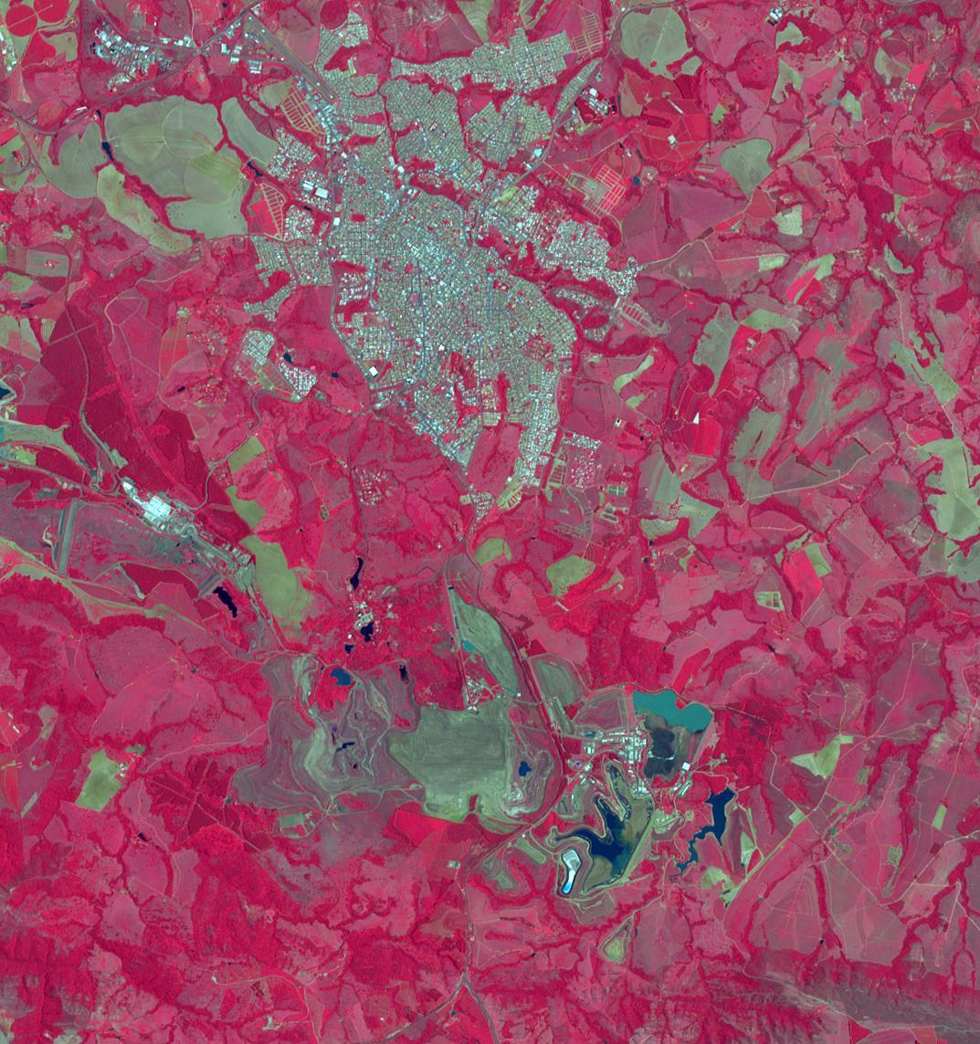
PIA26503:
-
French Overseas Territory of Mayotte, Indian Ocean
Full Resolution:
TIFF
(20.02 MB)
JPEG
(840.2 kB)
|
|
|
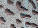
2024-12-20 |
Mars
|
Mars Reconnaissance Orbiter (MRO)
|
HiRISE
|
2560x1920x3 |
|
-
PIA26517:
-
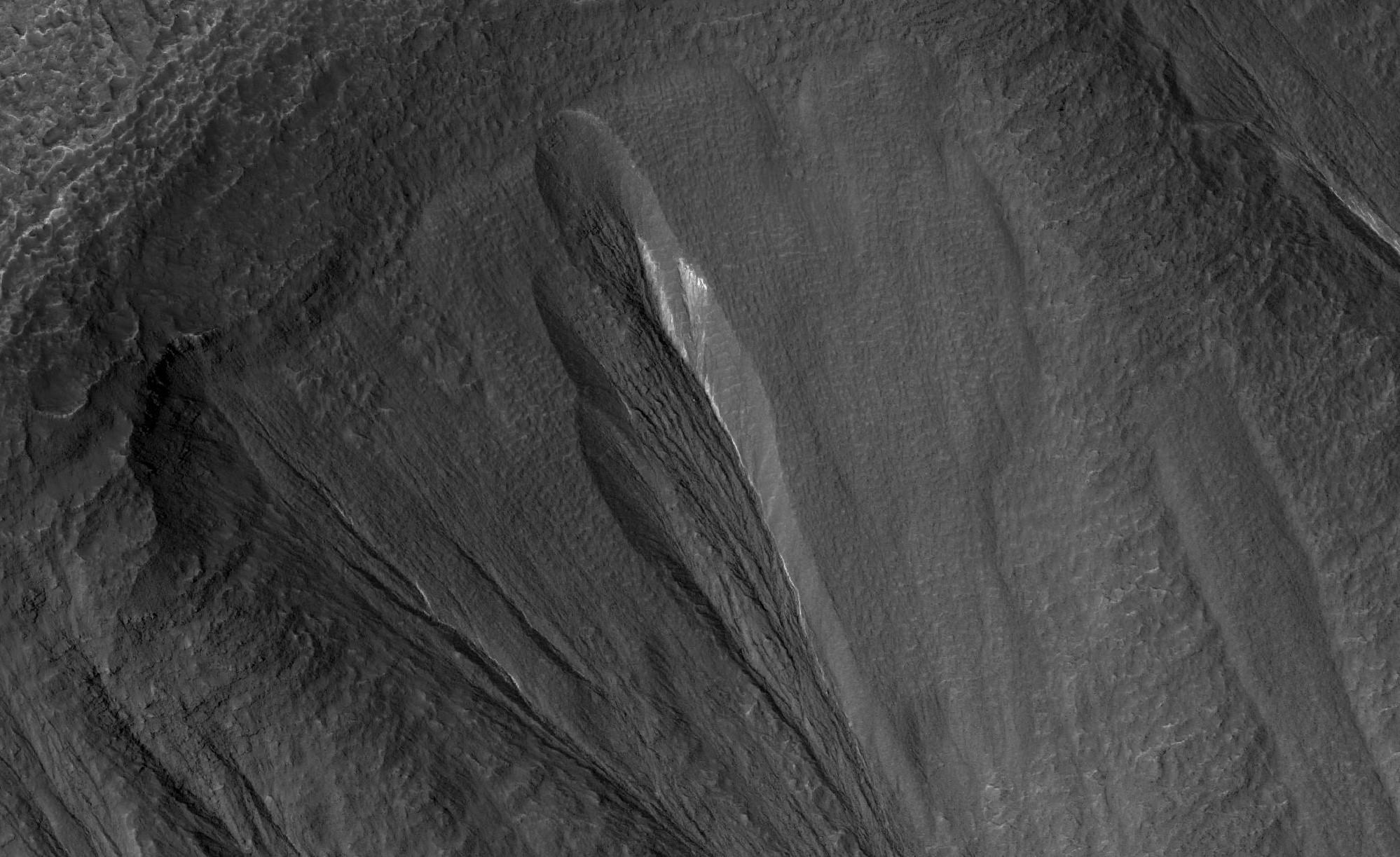
MRO's HiRISE Views Frosty Martian Dunes
Full Resolution:
TIFF
(14.75 MB)
JPEG
(1.424 MB)
|
|
|
2024-12-20 |
Earth
|
Terra
|
ASTER
|
1271x1616x3 |

|
-
PIA26502:
-
Barra Airport, Outer Hebrides, U.K.
Full Resolution:
TIFF
(3.589 MB)
JPEG
(132.3 kB)
|
|
|
2024-12-19 |
Mars
|
Mars Science Laboratory (MSL)
|
MARDI
|
2200x1238x3 |
|
-
PIA26516:
-
MARDI Peeks Under Curiosity
Full Resolution:
TIFF
(4.406 MB)
JPEG
(247.9 kB)
|
|
|
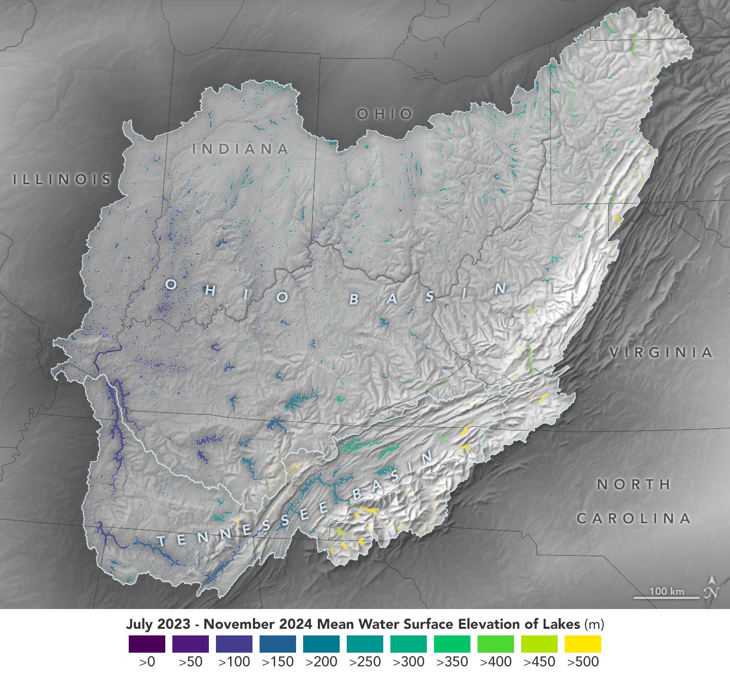
2024-12-17 |
Earth
|
SWOT
|
KaRIn
|
1440x1330x3 |

|
-
PIA26188:
-
Ohio Basin Lakes Water Levels
Full Resolution:
TIFF
(3.095 MB)
JPEG
(259.9 kB)
|
|
|
2024-12-16 |
Mars
|
Mars Science Laboratory (MSL)
|
Mastcam
|
27702x3937x3 |
|
-
PIA26477:
Curiosity Surveys 'Texoli'
Full Resolution:
TIFF
(197.7 MB)
JPEG
(15.08 MB)
|
|
|
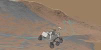
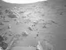
2024-12-12 |
Mars
|
Mars 2020 Rover
|
|
2466x1218x3 |
|
-
PIA26514:
-
View of Rover Driving Software During a Slippery Drive
Full Resolution:
TIFF
(4.863 MB)
JPEG
(200 kB)
|
|
|
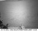
2024-12-12 |
Mars
|
Mars 2020 Rover
|
Navigation Camera (M2020)
|
640x516x1 |
|
-
PIA26513:
-
Perseverance Navcam Movie of a Slippery Drive
Full Resolution:
TIFF
(320.6 kB)
JPEG
(36.09 kB)
|
|
|
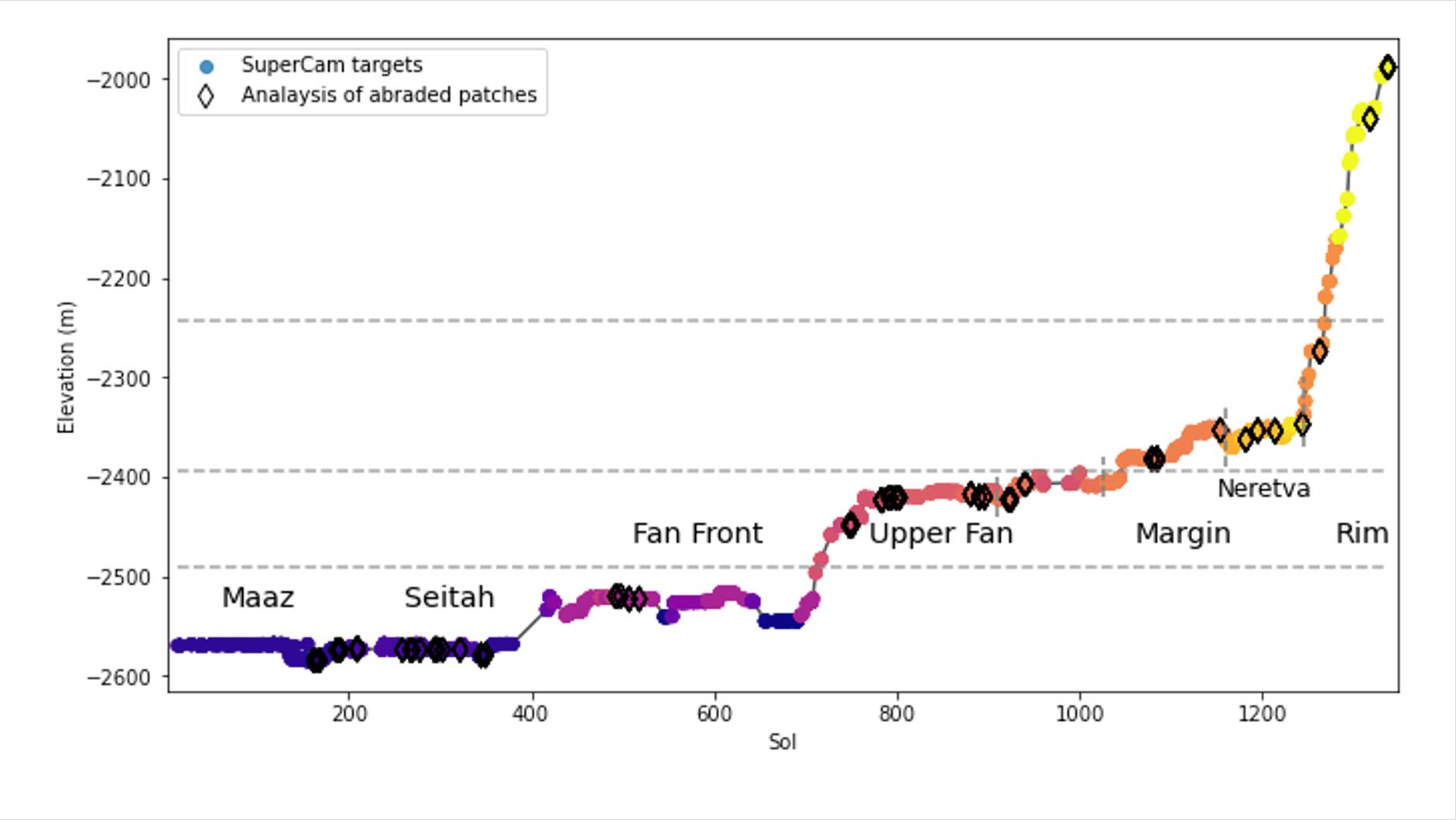
2024-12-12 |
Mars
|
Mars 2020 Rover
|
|
1881x1060x3 |

|
-
PIA26476:
-
Jezero Crater Elevation Graph
Full Resolution:
TIFF
(443.8 kB)
JPEG
(99.16 kB)
|
|
|
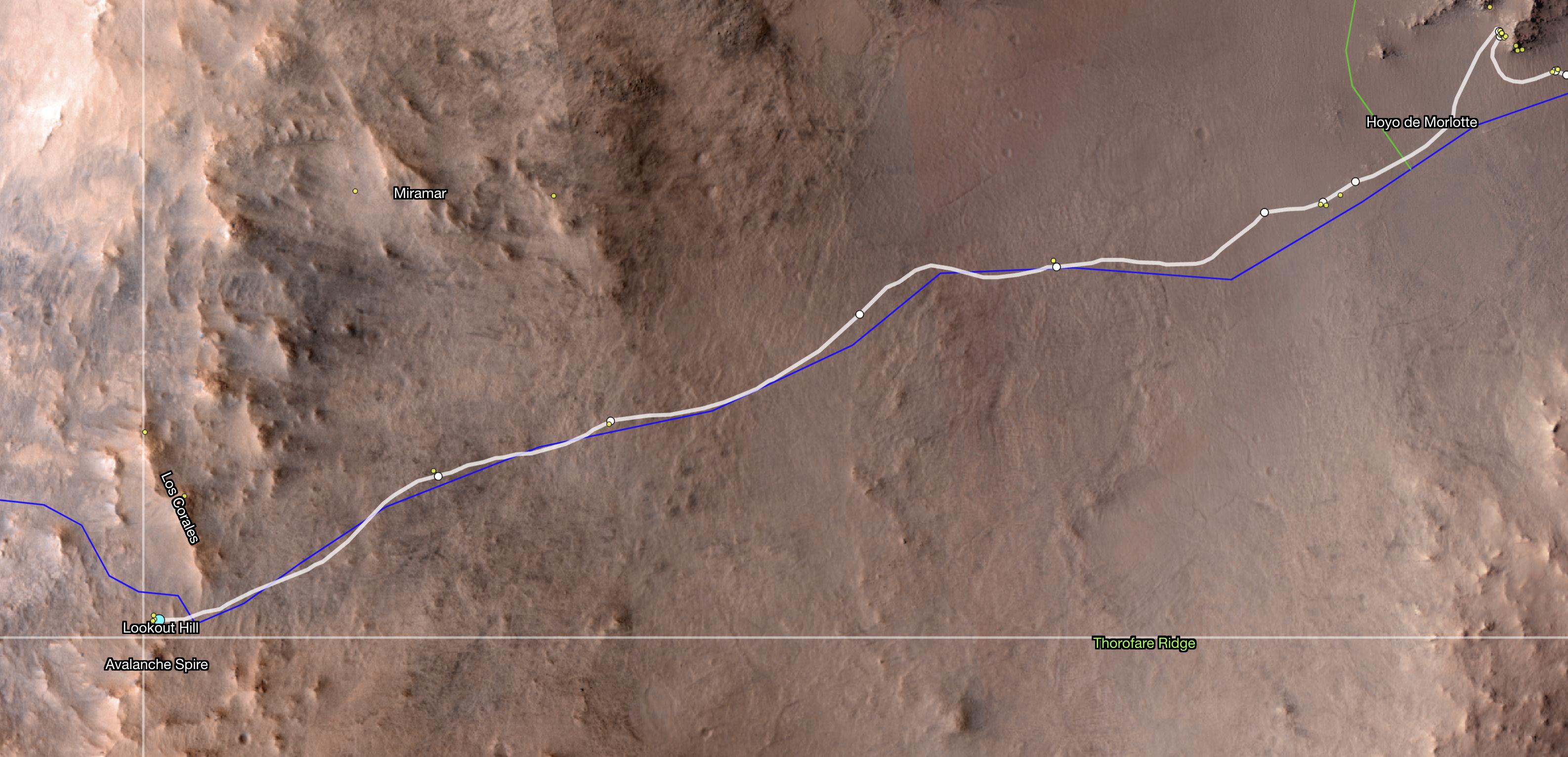
2024-12-12 |
Mars
|
Mars Reconnaissance Orbiter (MRO)
|
HiRISE
|
3173x1533x3 |
|
-
PIA26512:
-
Perseverance Reaches 'Lookout Hill'
Full Resolution:
TIFF
(12.71 MB)
JPEG
(504.7 kB)
|
|
|
2024-12-12 |
Mars
|
Mars 2020 Rover
|
Mastcam-Z
|
30000x7333x3 |
|
-
PIA26474:
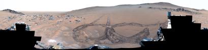
Perseverance Makes Tracks at 'Rio Chiquito'
Full Resolution:
TIFF
(454.3 MB)
JPEG
(30.81 MB)
|
|
|
2024-12-12 |
Mars
|
Mars 2020 Rover
|
Mastcam-Z
|
1490x368x3 |

|
-
PIA26473:
Perseverance Views 'Pico Turquino Hills'
Full Resolution:
TIFF
(457.7 kB)
JPEG
(48.5 kB)
|
|
|
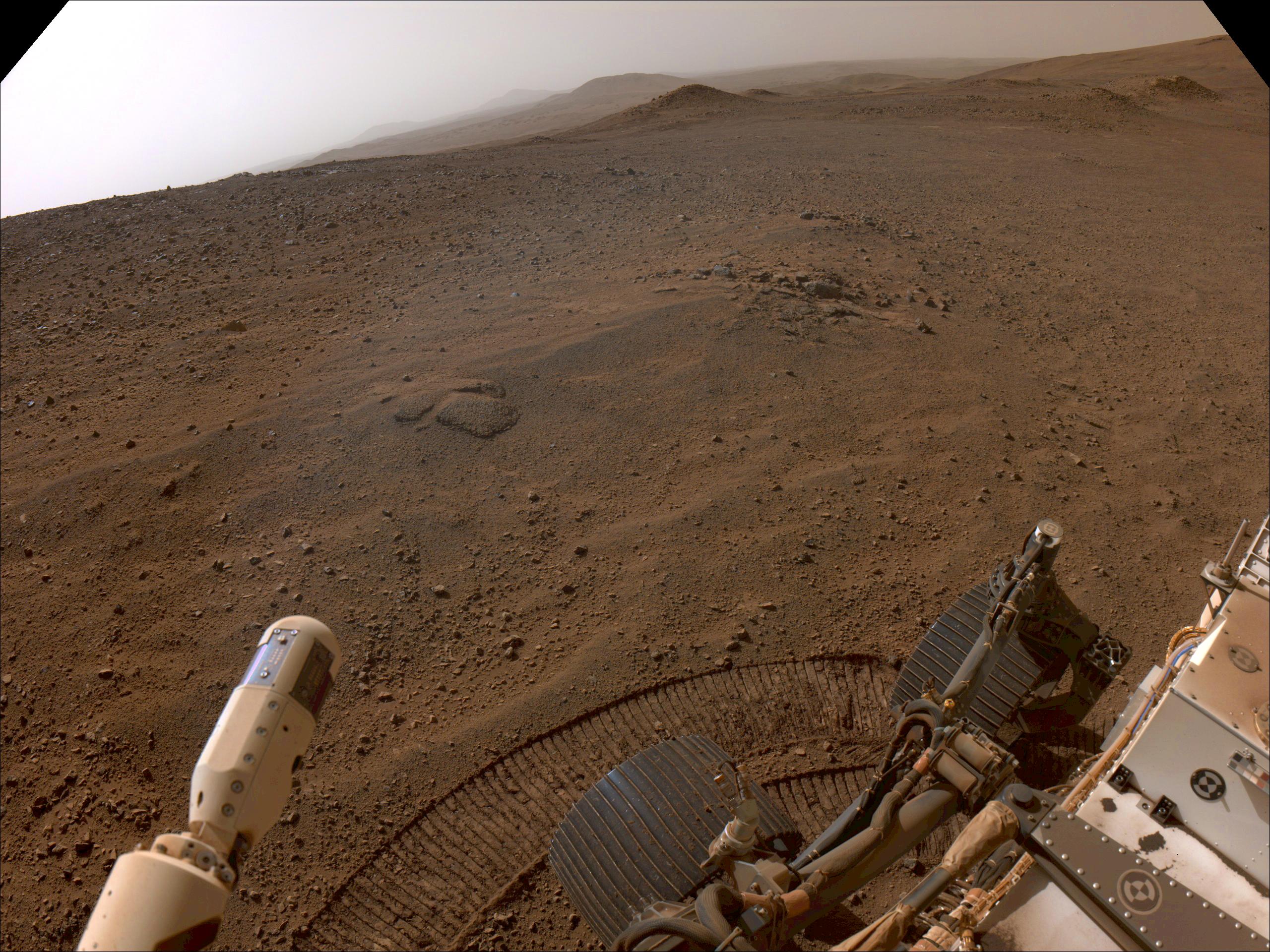
2024-12-12 |
Mars
|
Mars 2020 Rover
|
Navigation Camera (M2020)
|
2560x1920x3 |

|
-
PIA26511:
-
Perseverance's View From 'Lookout Hill'
Full Resolution:
TIFF
(11.36 MB)
JPEG
(826.8 kB)
|
|
|
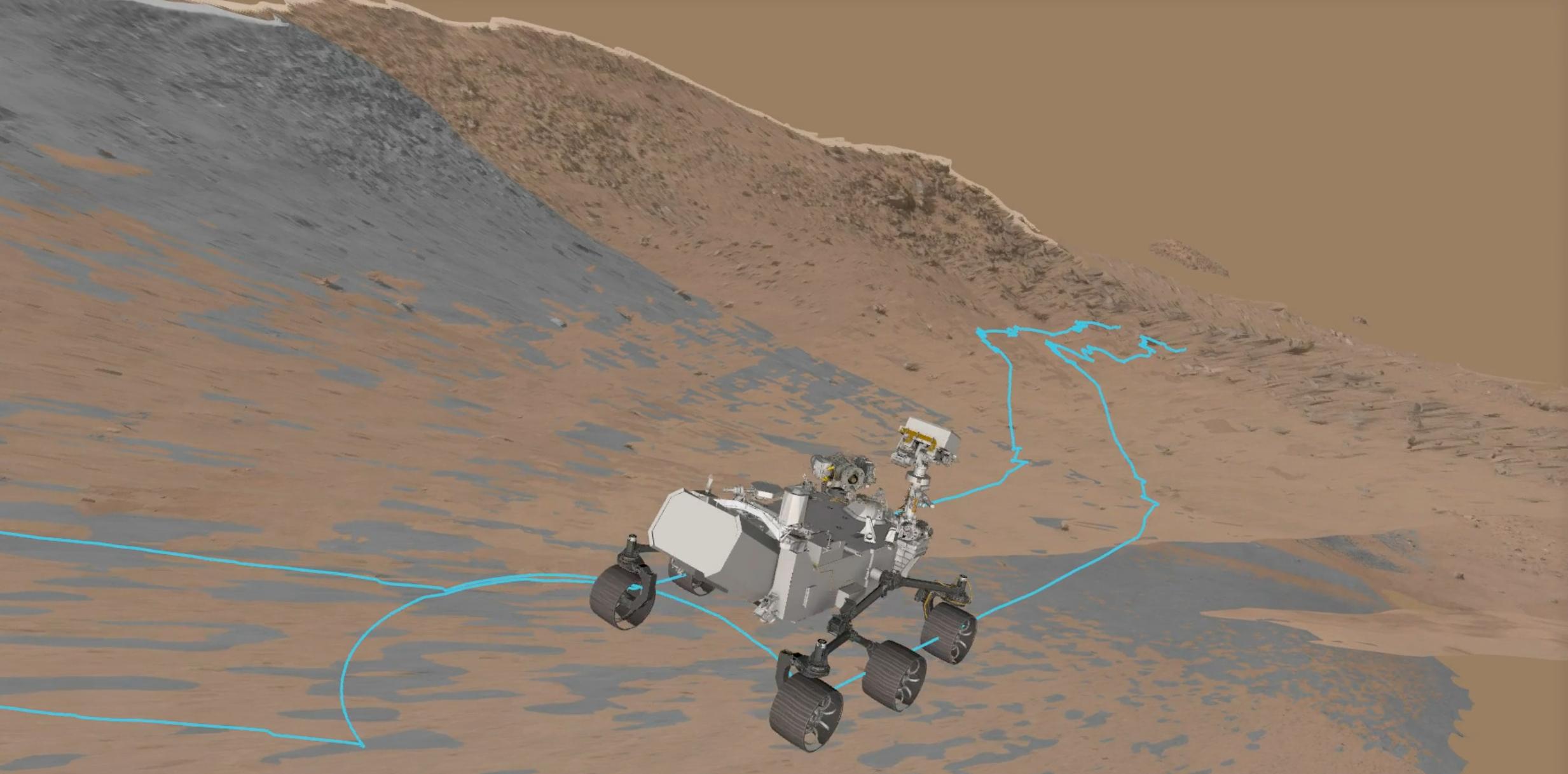
2024-12-12 |
Mars
|
Mars Reconnaissance Orbiter (MRO)
|
HiRISE
|
2156x1261x3 |
|
-
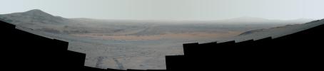
PIA26480:
-
Proposed Route of Perseverance's Northern Rim Science Campaign
Full Resolution:
TIFF
(8.16 MB)
JPEG
(352.4 kB)
|
|
|
2024-12-12 |
Mars
|
Mars 2020 Rover
|
Navigation Camera (M2020)
|
2560x1920x3 |
|
-
PIA26479:
-
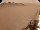
Perseverance Views Slippery Terrain
Full Resolution:
TIFF
(10.46 MB)
JPEG
(562.5 kB)
|
|
|
2024-12-12 |
Mars
|
Mars 2020 Rover
|
Mastcam-Z
|
24950x4073x3 |
|
-
PIA26475:
Proposed Route of Perseverance's Northern Rim Science Campaign
Full Resolution:
TIFF
(77.32 MB)
JPEG
(5.36 MB)
|
|
|
2024-11-29 |
Earth
|
Terra
|
ASTER
|
4345x5032x3 |
|
-
PIA26501:
-
Craters of the Moon National Monument, Idaho
Full Resolution:
TIFF
(62.01 MB)
JPEG
(3.164 MB)
|
|
|
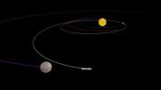
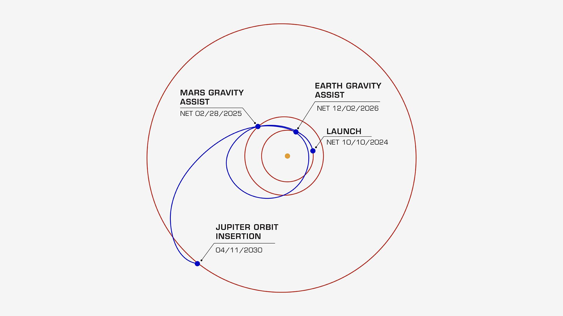
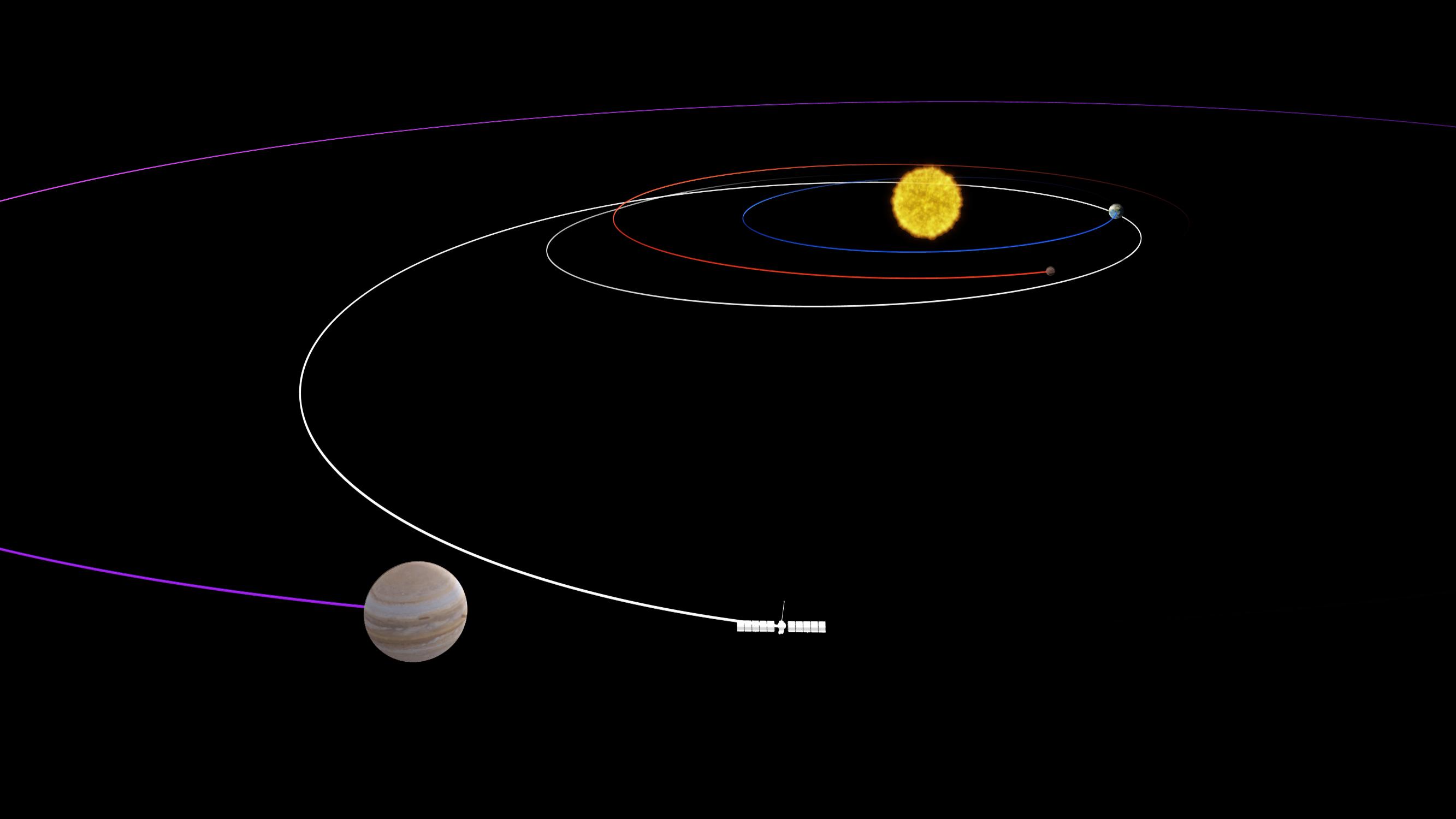
2024-11-26 |
Europa
|
Europa Clipper
|
|
1920x1080x3 |
|
-
PIA26435:
-
Europa Clipper's Trajectory to Jupiter
Full Resolution:
TIFF
(345.7 kB)
JPEG
(87.15 kB)
|
|
|
2024-11-18 |
Mars
|
Mars Science Laboratory (MSL)
|
Mastcam
|
10053x2868x3 |
|
-
PIA26472:
Curiosity Views the Yardang Unit
Full Resolution:
TIFF
(52.82 MB)
JPEG
(3.95 MB)
|
|
|
2024-11-18 |
Mars
|
Mars Science Laboratory (MSL)
|
Mastcam
|
29239x8234x3 |
|
-
PIA26410:
Curiosity's View Within Gediz Vallis Channel
Full Resolution:
TIFF
(483.2 MB)
JPEG
(41.38 MB)
|
|
|
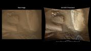
2024-11-18 |
Mars
|
Mars Reconnaissance Orbiter (MRO)
|
HiRISE
|
7488x3813x1 |

|
-
PIA26306:
-
HiRISE Views Mount Sharp's Boxwork
Full Resolution:
TIFF
(14.1 MB)
JPEG
(2.659 MB)
|
|
|
2024-11-18 |
Mars
|
Mars Science Laboratory (MSL)
|
Mastcam
|
5818x2555x3 |
|
-
PIA26210:
-
Curiosity Takes a Last Look at Sulfur Stones
Full Resolution:
TIFF
(31.85 MB)
JPEG
(2.504 MB)
|
|
|
2024-11-18 |
Mars
|
Mars Science Laboratory (MSL)
|
Mastcam
|
29240x7369x3 |
|
-
PIA26471:
Curiosity Makes Rover Tracks While Heading West
Full Resolution:
TIFF
(473.5 MB)
JPEG
(38.24 MB)
|
|
|
2024-11-15 |
Earth
|
Terra
|
ASTER
|
2381x2419x3 |

|
-
PIA26450:
-
Pontic Range, Turkey
Full Resolution:
TIFF
(17.25 MB)
JPEG
(921.4 kB)
|
|
|
2024-11-14 |
Earth
|
Earth Surface Mineral Dust Source Investigation (EMIT)
|
EMIT
|
1771x1179x3 |
|
-
PIA26418:
-
NASA's EMIT Collects Data on Mid-Atlanic Plant Communities
Full Resolution:
TIFF
(6.267 MB)
JPEG
(631.5 kB)
|
|
|
2024-11-14 |
Earth
|
Earth Surface Mineral Dust Source Investigation (EMIT)
|
EMIT
|
1942x1356x3 |
|
-
PIA26417:
-
NASA's EMIT Scans the Amazon River in Northern Brazil
Full Resolution:
TIFF
(7.903 MB)
JPEG
(575.4 kB)
|
|
|
2024-11-07 |
Mars
|
Mars 2020 Rover
|
Mastcam-Z
|
7595x4785x3 |
|
-
PIA26481:
-
NASA's Perseverance Observes 'Observation Rock'
Full Resolution:
TIFF
(68.79 MB)
JPEG
(3.65 MB)
|
|
|
2024-10-31 |
Earth
|
Terra
|
ASTER
|
1807x2042x3 |
|
-
PIA26449:
-
Nyamulagira Volcano, Democratic Republic Congo
Full Resolution:
TIFF
(9.954 MB)
JPEG
(282.2 kB)
|
|
|
2024-10-30 |
Phobos
|
Mars 2020 Rover
|
Mastcam-Z
|
1600x900x3 |
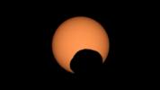
|
-
PIA26380:
-
Perseverance Captures Transit of Phobos
Full Resolution:
TIFF
(639.5 kB)
JPEG
(31.72 kB)
|
|
|
2024-10-29 |
Moon
|
|
Cold Operable Lunar Deployable Arm (COLDArm)
|
3840x2160x3 |
|
-
PIA26347:
-
NASA's COLDArm Operating on the Moon (Animation)
Full Resolution:
TIFF
(8.895 MB)
JPEG
(369.9 kB)
|
|
|
2024-10-28 |
Mars
|
Mars 2020 Rover
|
Navigation Camera (M2020)
|
2560x1920x3 |
|
-
PIA26379:
-
Tracks Tell Tale of Perseverance's Crater Rim Climb
Full Resolution:
TIFF
(11.99 MB)
JPEG
(513.4 kB)
|
|
|
2024-10-28 |
Mars
|
Mars 2020 Rover
|
Navigation Camera (M2020)
|
477x330x1 |
|
-
PIA26377:
-
Perseverance Drives Backward Up Jezero Crater's Rim
Full Resolution:
TIFF
(157.8 kB)
JPEG
(34.13 kB)
|
|
|
2024-10-28 |
Mars
|
Mars 2020 Rover
|
Mastcam-Z
|
24566x5406x3 |
|
-
PIA26378:
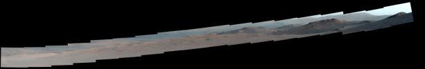
Perseverance's Mid-Climb View of Jezero Crater
Full Resolution:
TIFF
(187.1 MB)
JPEG
(10.2 MB)
|
|
|
2024-10-25 |
Earth
|
Terra
|
ASTER
|
1500x1100x3 |
|
-
PIA26448:
-
Klamath River, OR and CA
Full Resolution:
TIFF
(4.952 MB)
JPEG
(377.9 kB)
|
|
|
2024-10-25 |
Earth
|
Terra
|
ASTER
|
1025x937x3 |
|
-
PIA26447:
-
Humboldt Glacier, Venezuela
Full Resolution:
TIFF
(2.883 MB)
JPEG
(164 kB)
|
|
|
2024-10-23 |
|
NISAR
|
|
8272x6200x3 |

|
-
PIA26419:
-
NISAR Radar Antenna Reflector Loaded for Return to India
Full Resolution:
TIFF
(104.6 MB)
JPEG
(4.395 MB)
|
|
|
2024-10-17 |
Earth
|
|
|
4928x3264x3 |

|
-
PIA26409:
-
Cryoconite Holes on Matanuska Glacier
Full Resolution:
TIFF
(24.12 MB)
JPEG
(923.8 kB)
|
|
|
2024-10-11 |
Europa
|
Europa Clipper
|
|
3840x2160x3 |
|
-
PIA26103:
-
Icy Moons in Our Solar System That May Have Oceans Now
Full Resolution:
TIFF
(4.458 MB)
JPEG
(307.2 kB)
|
|
|
2024-10-10 |
Mars
|
Mars Reconnaissance Orbiter (MRO)
|
HiRISE
|
1998x1223x1 |

|
-
PIA26408:
-
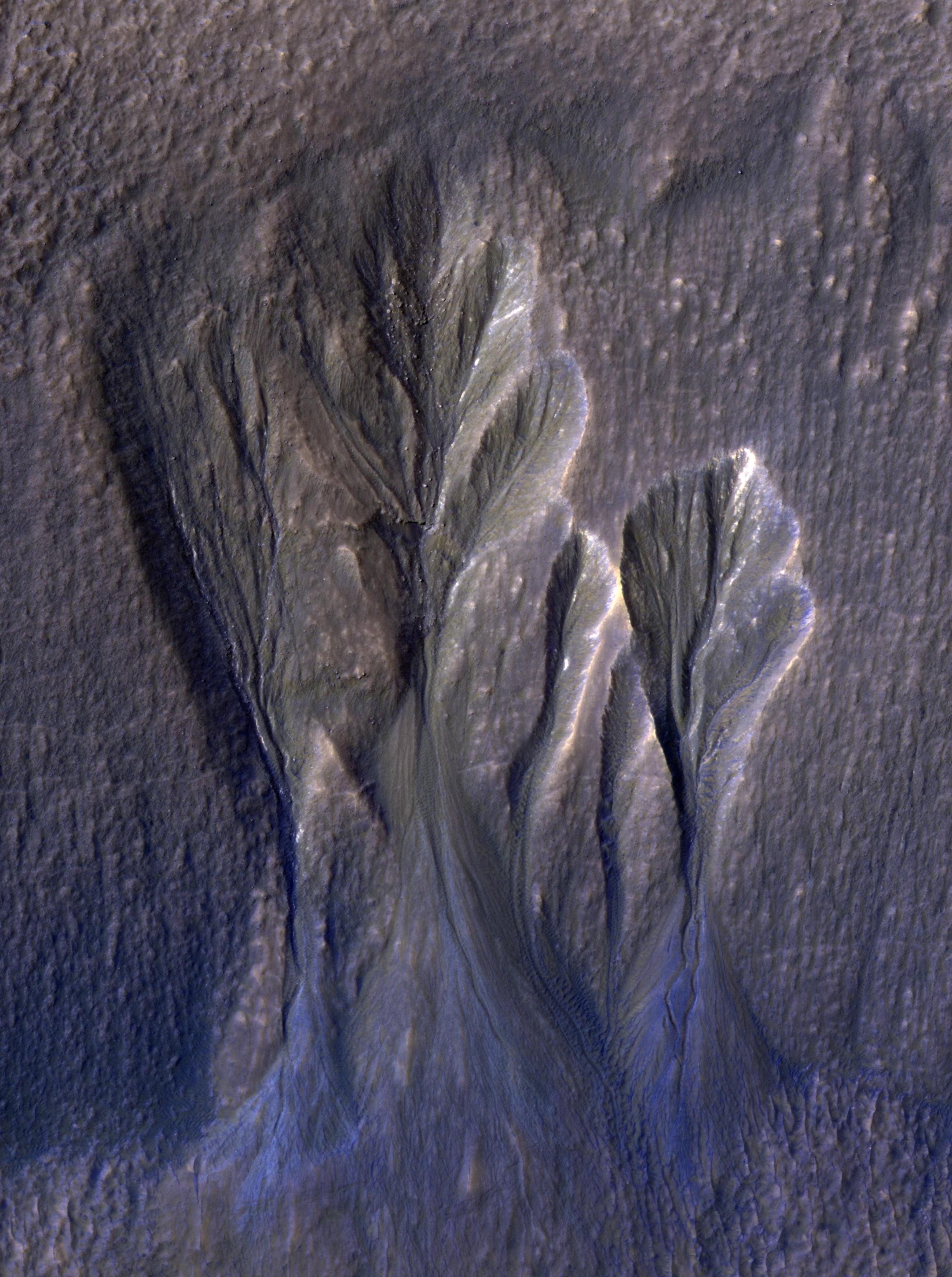
Dusty Water Ice in Mars' Dao Vallis
Full Resolution:
TIFF
(2.361 MB)
JPEG
(310.2 kB)
|
|
|
2024-10-10 |
Mars
|
Mars Reconnaissance Orbiter (MRO)
|
HiRISE
|
3232x4333x3 |
|
-
PIA26407:
-
Dusty Water Ice in Mars' Terra Sirenum
Full Resolution:
TIFF
(41.04 MB)
JPEG
(1.397 MB)
|
|
|
2024-10-02 |
Europa
|
Galileo
|
Solid-State Imaging
|
1024x425x3 |
|
-
PIA26446:
-
Conamara Color Closeup
Full Resolution:
TIFF
(1.306 MB)
JPEG
(112.2 kB)
|
|
|
2024-10-02 |
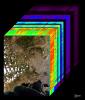
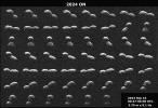
Asteroid
|
|
ATLAS
|
1367x970x3 |
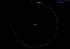
|
-
PIA26452:
-
Asteroid 2024 PT5's Orbit Around the Sun (Animation)
Full Resolution:
TIFF
(195.3 kB)
JPEG
(38.41 kB)
|
|
|
2024-10-02 |
Earth
|
|
SAR
|
2480x3507x3 |
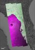
|
-
PIA26414:
-
NASA's OPERA Project Generates Radar Image of Hurricane Helene
Full Resolution:
TIFF
(18.81 MB)
JPEG
(2.337 MB)
|
|
|
2024-09-27 |
Earth
|
Aqua
|
AIRS
|
900x695x3 |
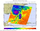
|
-
PIA26413:
-
NASA's AIRS Instrument Captures Hurricane Helene
Full Resolution:
TIFF
(805.8 kB)
JPEG
(118 kB)
|
|
|
2024-09-27 |
Earth
|
Terra
|
ASTER
|
1073x1143x3 |
|
-
PIA26395:
-
Araxa Mine, Brazil
Full Resolution:
TIFF
(3.681 MB)
JPEG
(251.1 kB)
|
|
|
2024-09-25 |
Earth
|
Carbon Mapper Coalition
|
Carbon Mapper Imaging Spectrometer
|
1133x1326x3 |
|
-
PIA26412:
-
Tanager-1 First Light
Full Resolution:
TIFF
(2.663 MB)
JPEG
(215.2 kB)
|
|
|
2024-09-17 |
Asteroid
|
Deep Space Network (DSN)
|
Deep Space Network
|
4757x3262x1 |
|
-
PIA26451:
-
NASA's Planetary Radar Spies (Another) Peanut-Shaped Asteroid
Full Resolution:
TIFF
(11.11 MB)
JPEG
(3.026 MB)
|
|
|
2024-09-13 |
Mars
|
Mars 2020 Rover
|
Navigation Camera (M2020)
|
1280x960x1 |
|
-
PIA26376:
-
NASA's Perseverance Is Going Up and Up
Full Resolution:
TIFF
(701.1 kB)
JPEG
(151 kB)
|
|
|
2024-09-13 |
Earth
|
ECOSTRESS
|
|
3507x2480x3 |
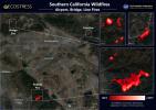
|
-
PIA26187:
-
Southern California Wildfires Captured by NASA's ECOSTRESS
Full Resolution:
TIFF
(19.8 MB)
JPEG
(1.341 MB)
|
|
|
2024-09-13 |
Mars
|
Mars Science Laboratory (MSL)
|
Mastcam
|
1080x2100x3 |

|
-
PIA26362:
-
Curiosity Views Earth Setting, Phobos Rising
Full Resolution:
TIFF
(4.06 MB)
JPEG
(111.7 kB)
|
|
|
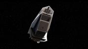
2024-09-10 |
Europa
|
Europa Clipper
|
|
1921x1081x3 |
|
-
PIA26434:
-
Europa's Mysterious Interior (Artist's Concept)
Full Resolution:
TIFF
(1.076 MB)
JPEG
(92.32 kB)
|
|
|
2024-09-09 |
Europa
|
Europa Clipper
|
|
3840x2160x3 |
|
-
PIA26441:
-
Preparing for Planetary Protection Analysis
Full Resolution:
TIFF
(19.82 MB)
JPEG
(542.6 kB)
|
|
|
2024-09-09 |
Europa
|
Europa Clipper
|
|
3840x2160x3 |
|
-
PIA26440:
-
Keeping Europa Clipper Clean
Full Resolution:
TIFF
(20.63 MB)
JPEG
(576.4 kB)
|
|
|
2024-09-09 |
Europa
|
Europa Clipper
|
|
2550x2700x3 |
|
-
PIA26438:
-
Europa's Mysterious Interior (Artist's Concept)
Full Resolution:
TIFF
(12.34 MB)
JPEG
(469.9 kB)
|
|
|
2024-09-09 |
Europa
|
Europa Clipper
|
|
1921x1080x3 |
|
-
PIA26436:
-
Europa Clipper's Elliptical Orbit
Full Resolution:
TIFF
(605.2 kB)
JPEG
(105.8 kB)
|
|
|
2024-09-09 |
Europa
|
Europa Clipper
|
|
2666x1500x3 |
|
-
PIA26432:
-
Europa Clipper's Looping Journey to Jupiter (Artist's Concept)
Full Resolution:
TIFF
(550.2 kB)
JPEG
(105.7 kB)
|
|
|
2024-08-30 |
Earth
|
Terra
|
ASTER
|
613x565x3 |

|
-
PIA26394:
-
Terra Cotta Army, China
Full Resolution:
TIFF
(1.04 MB)
JPEG
(103 kB)
|
|
|
2024-08-29 |
Asteroid
|
Deep Space Network (DSN)
|
Deep Space Network
|
1474x990x1 |
|
-
PIA26389:
-
Goldstone Planetary Radar Observes Peanut-Shaped Asteroid
Full Resolution:
TIFF
(1.226 MB)
JPEG
(269.2 kB)
|
|
|
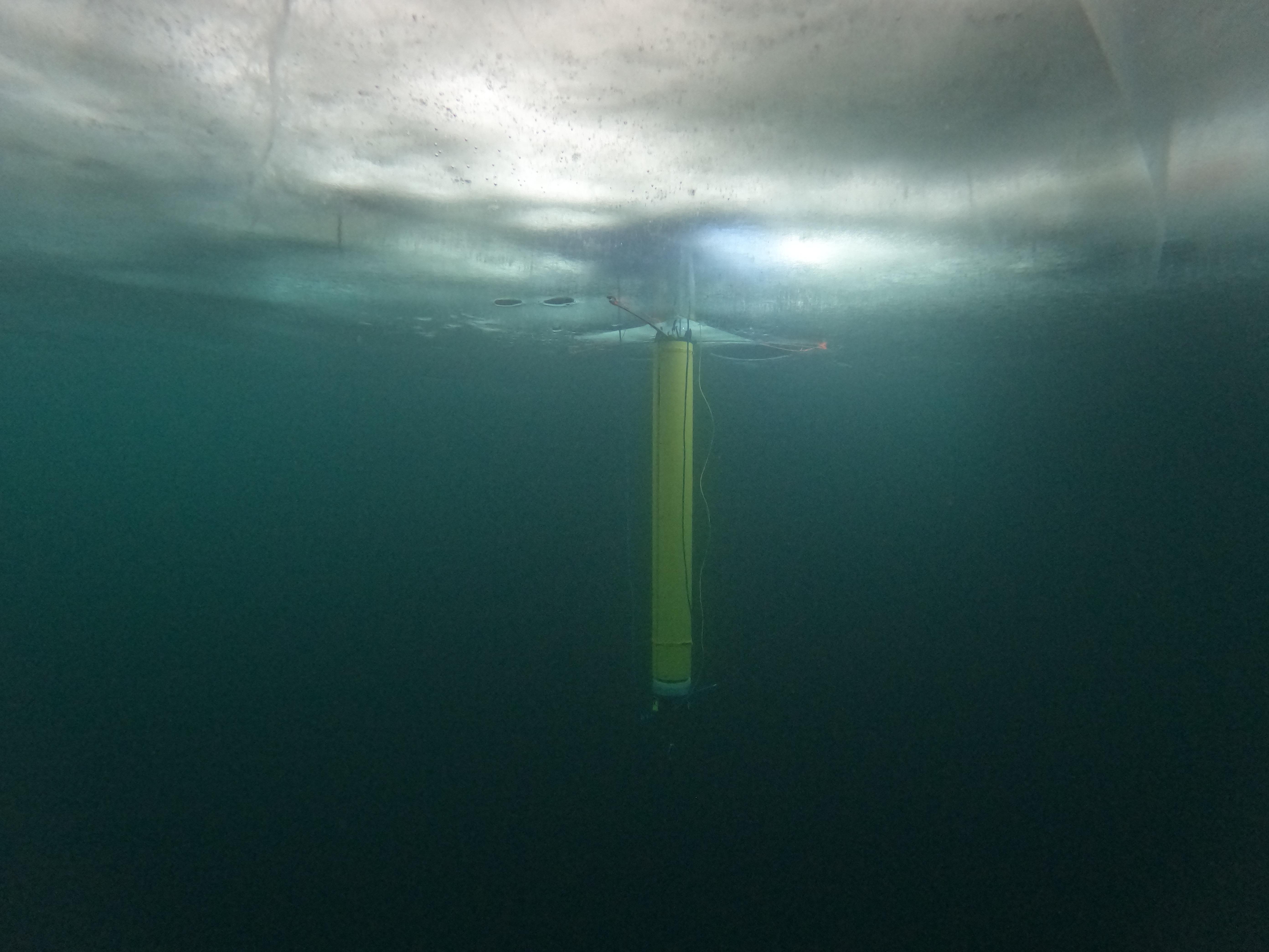
2024-08-29 |
|
IceNode
|
|
5568x4176x3 |

|
-
PIA26421:
-
IceNode Prototype Under the Ice
Full Resolution:
TIFF
(36.13 MB)
JPEG
(1.332 MB)
|
|
|
2024-08-29 |
|
IceNode
|
|
8169x4595x3 |

|
-
PIA26349:
-
Arctic Test for JPL's IceNode Prototype
Full Resolution:
TIFF
(71.71 MB)
JPEG
(2.528 MB)
|
|
|
2024-08-28 |
|
NEO Surveyor
|
|
2295x1291x3 |
|
-
PIA26388:
-
NASA's NEO Surveyor in Deep Space (Artist's Concept)
Full Resolution:
TIFF
(2.219 MB)
JPEG
(170.2 kB)
|
 Planetary Data System


