My
List |
Addition Date
|
Target
|
Mission
|
Instrument
|
Size
|

|
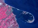
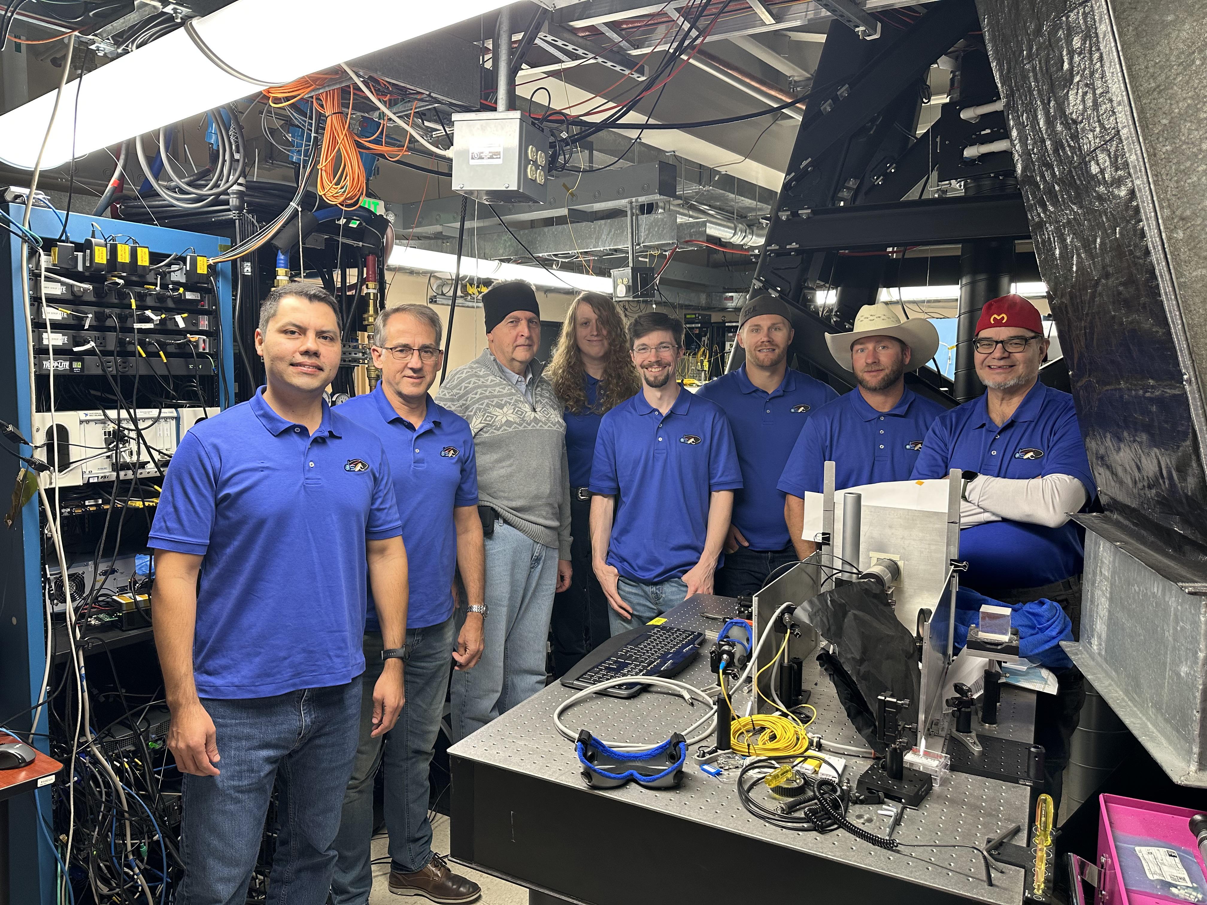
2023-11-16 |
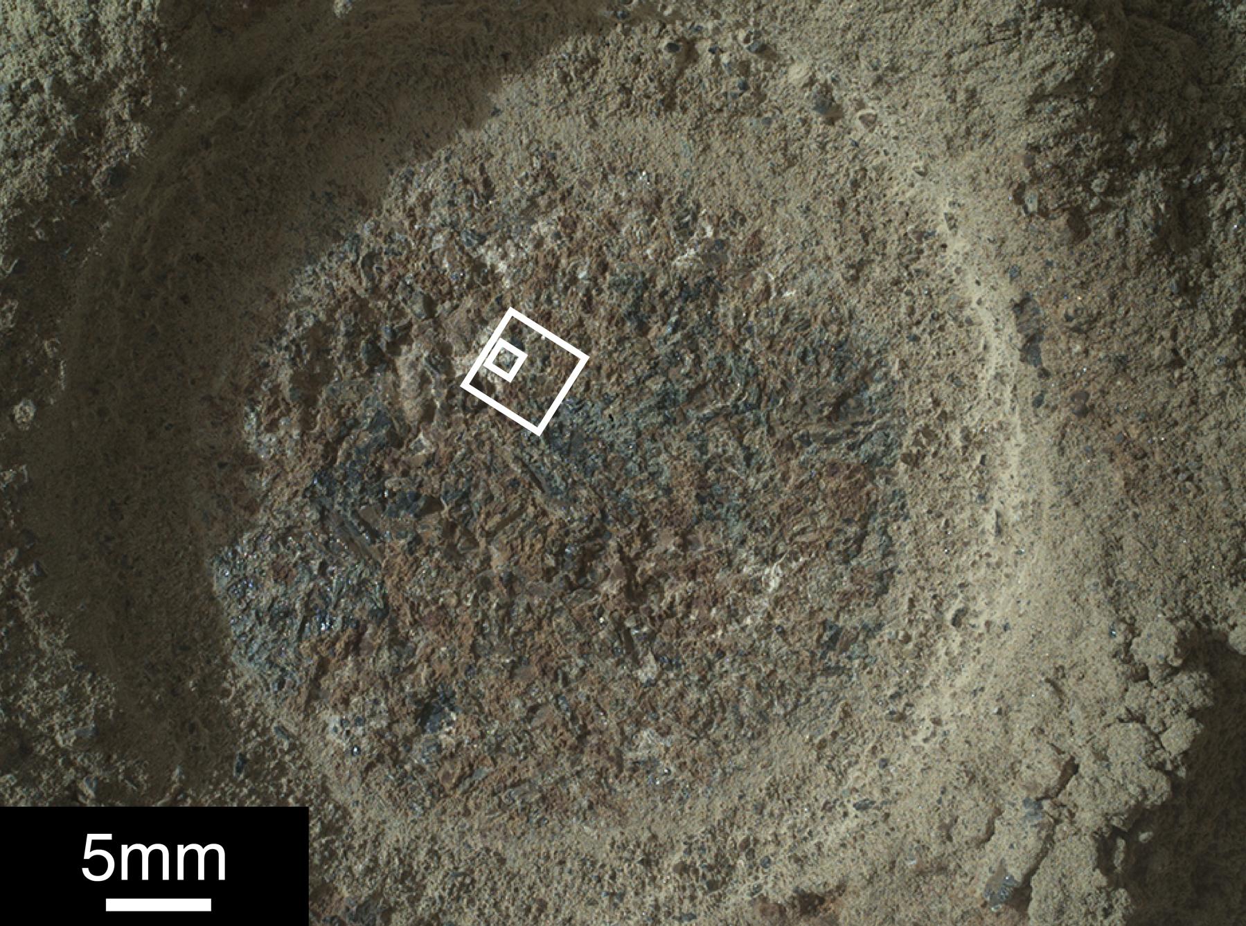
|
Psyche
|
Deep Space Optical Communications (DSOC)
|
4032x3024x3 |
|
-
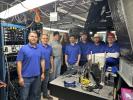
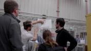
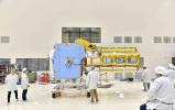
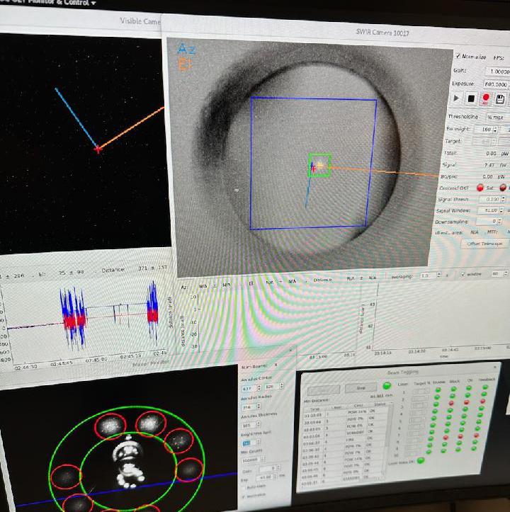
PIA26144:
-
The DSOC Ground Laser Transmitter Team After 'First Light'
Full Resolution:
TIFF
(34.67 MB)
JPEG
(1.96 MB)
|
|
|
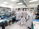
2023-11-16 |
|
Psyche
|
Deep Space Optical Communications (DSOC)
|
2000x1500x3 |

|
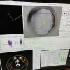
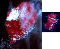
-
PIA26143:
-
DSOC 'First Light' at JPL's Psyche Mission Support Area
Full Resolution:
TIFF
(8.736 MB)
JPEG
(359.8 kB)
|
|
|
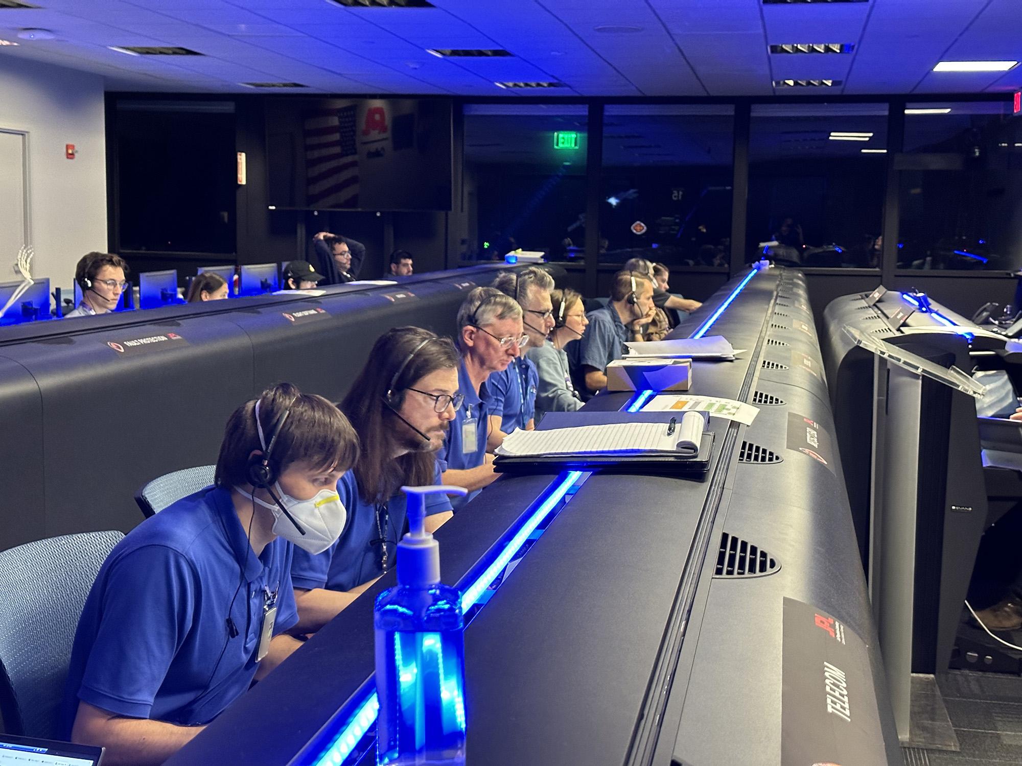
2023-11-16 |
|
Psyche
|
Deep Space Optical Communications (DSOC)
|
720x723x3 |
|
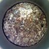
-
PIA26142:
-
Confirmation of DSOC 'First Light' at JPL's Table Mountain
Full Resolution:
TIFF
(1.295 MB)
JPEG
(89.04 kB)
|
|
|
2023-11-15 |
Mars
|
2001 Mars Odyssey
|
THEMIS
|
608x2700x1 |
|
-
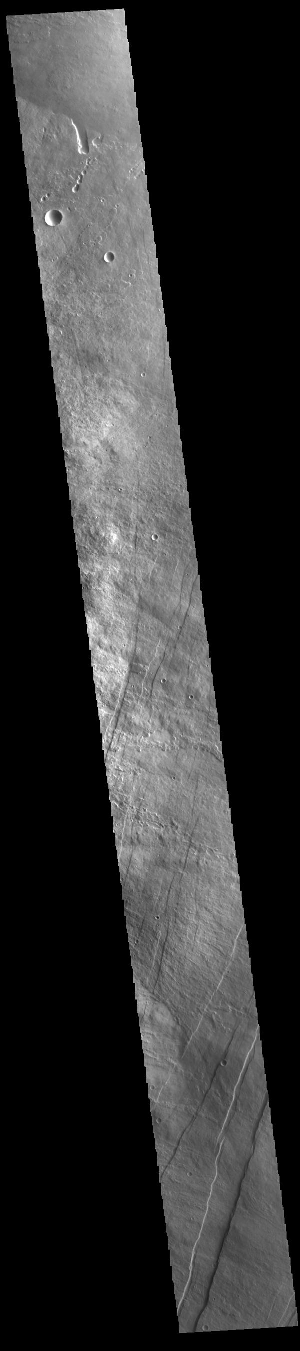
PIA26218:
-
Ascraeus Mons Flank
Full Resolution:
TIFF
(772.9 kB)
JPEG
(105.8 kB)
|
|
|
2023-11-14 |
|
NISAR
|
|
1600x1066x3 |
|
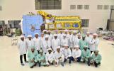
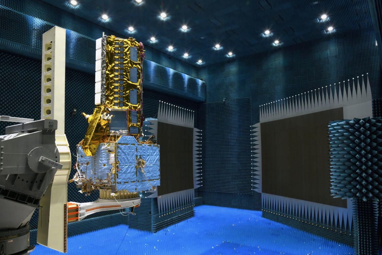
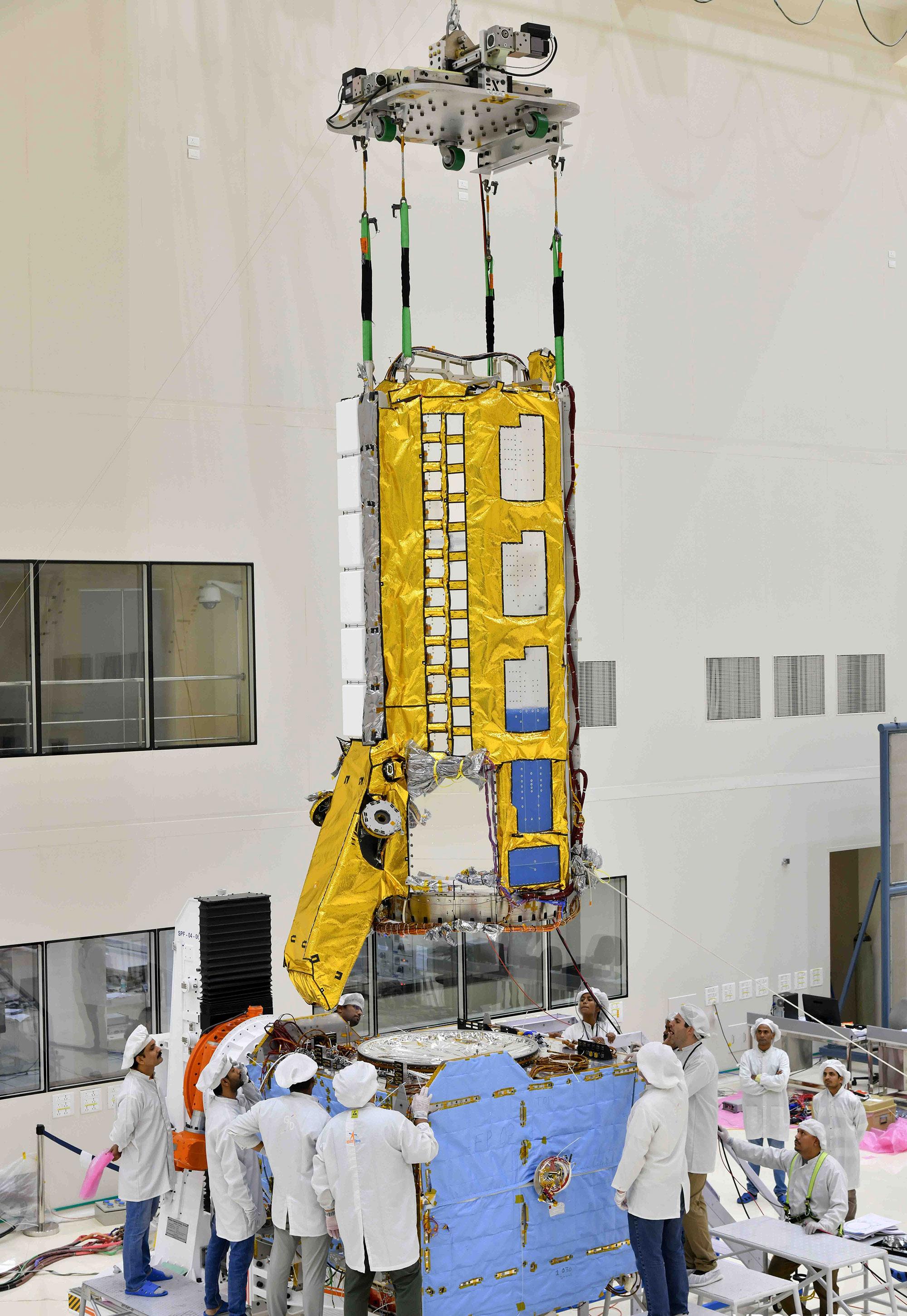
-
PIA26115:
-
NISAR Completes Trial in ISRO's Compact Antenna Test Facility
Full Resolution:
TIFF
(5.019 MB)
JPEG
(239.2 kB)
|
|
|
2023-11-14 |
|
NISAR
|
|
1665x1131x3 |
|
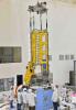
-
PIA26114:
-
NISAR Passes Thermal Vacuum Test in Indian Spacecraft Facility
Full Resolution:
TIFF
(5.618 MB)
JPEG
(253.6 kB)
|
|
|
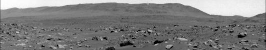
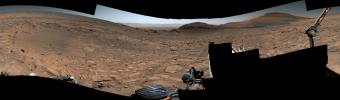
2023-11-10 |
Mars
|
Mars 2020 Rover
|
Navigation Camera (M2020)
|
2560x1920x3 |
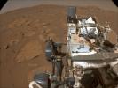
|
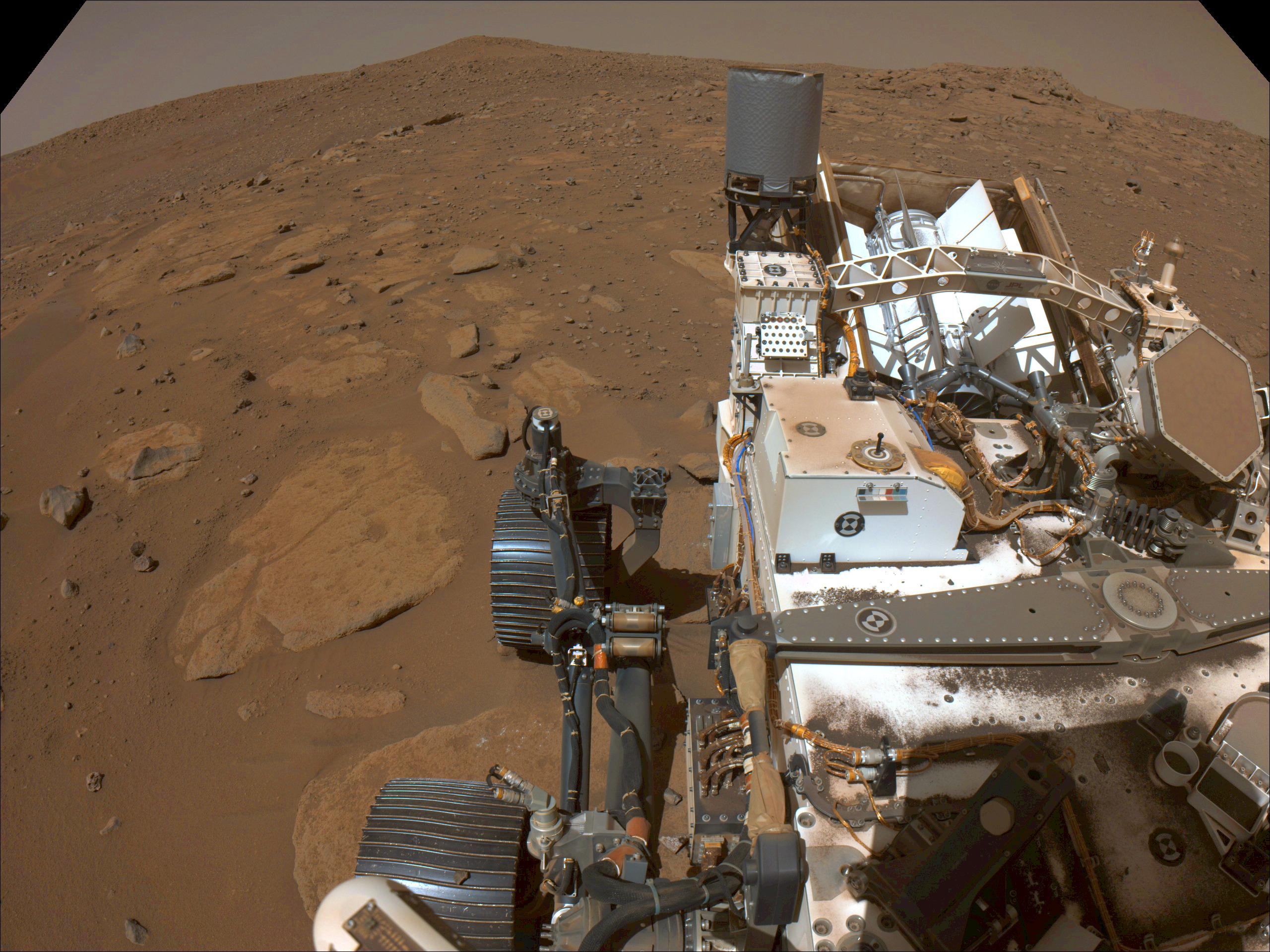
-
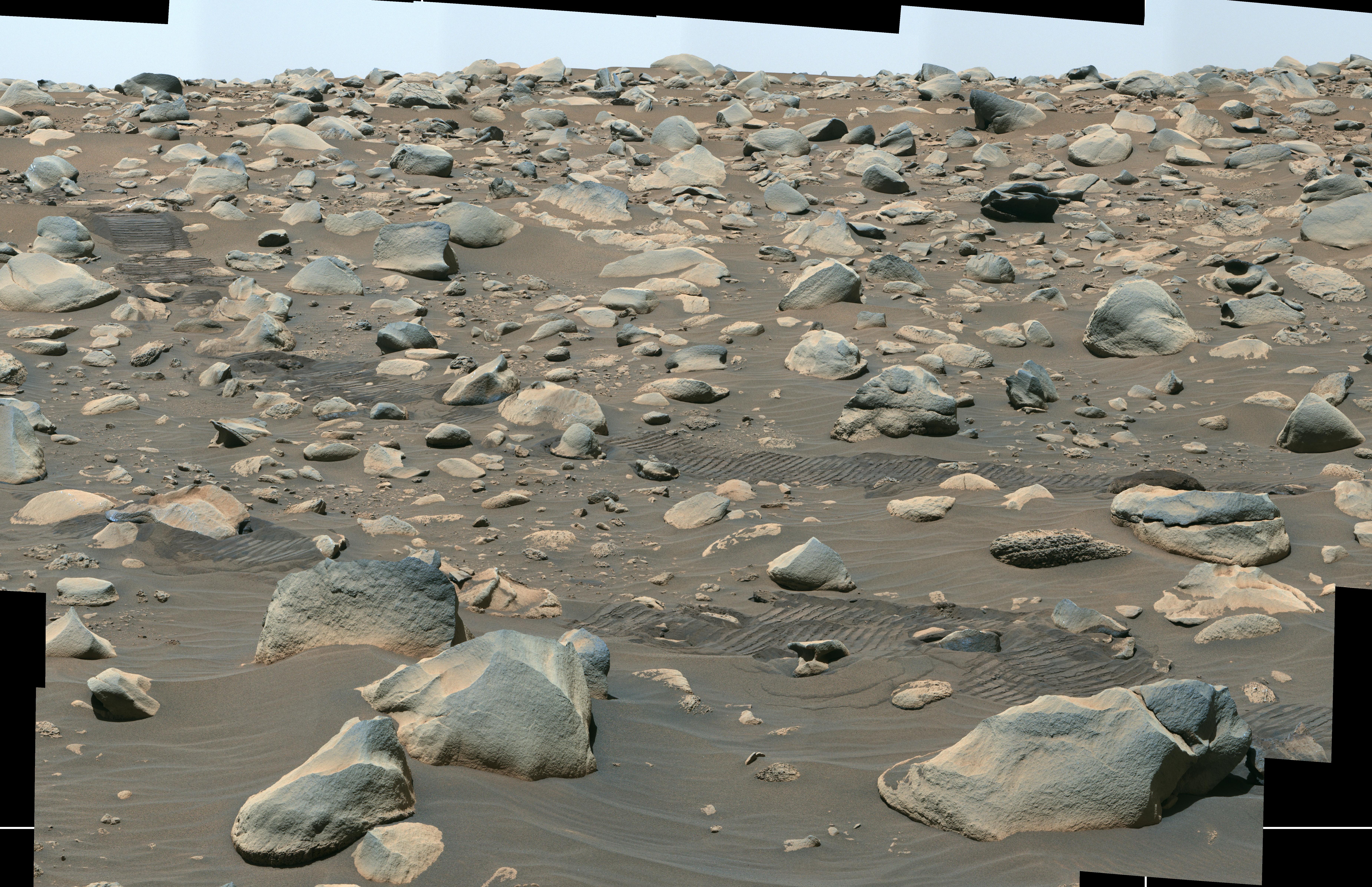
PIA26202:
-
Perseverance's Parking Spot During Conjunction
Full Resolution:
TIFF
(14.75 MB)
JPEG
(620.3 kB)
|
|
|
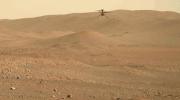
2023-11-10 |
Mars
|
Mars Helicopter
|
|
4208x3120x3 |
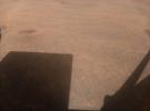
|
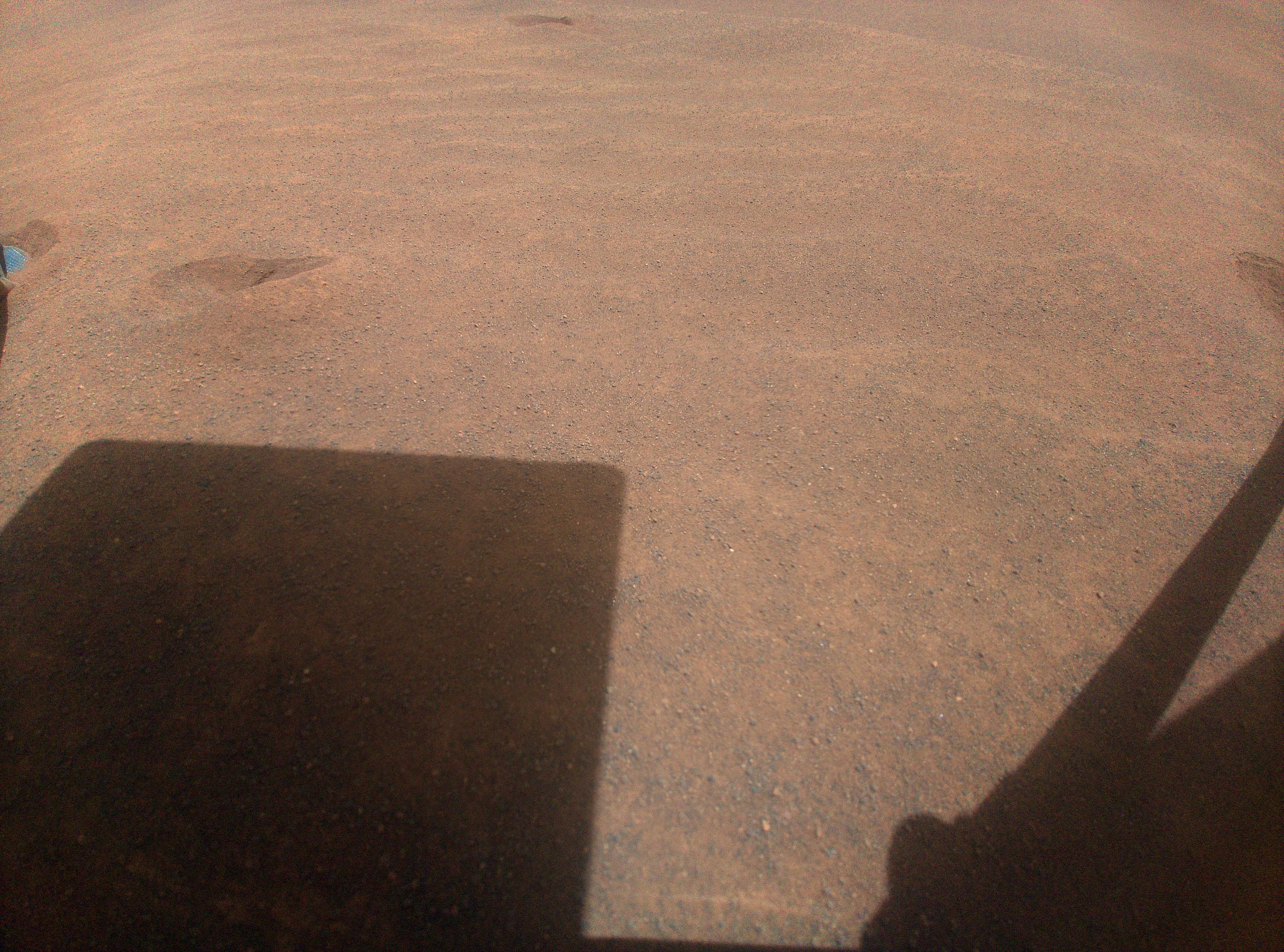
-
PIA26050:
-
Ingenuity's View of Sand Going Into Conjunction
Full Resolution:
TIFF
(39.41 MB)
JPEG
(2.59 MB)
|
|
|
2023-11-09 |
|
SPHEREx
|
|
8256x5504x3 |

|
-
PIA25787:
-
SPHEREx Telescope at JPL
Full Resolution:
TIFF
(81.03 MB)
JPEG
(4.342 MB)
|
|
|
2023-11-09 |
|
SPHEREx
|
|
8256x5504x3 |

|
-
PIA25785:
-
SPHEREx Photon Shields Assembled
Full Resolution:
TIFF
(106.9 MB)
JPEG
(6.847 MB)
|
|
|
2023-11-09 |
|
SPHEREx
|
|
4032x2268x3 |
|
-
PIA25784:
-
SPHEREx Outer Photon Shield
Full Resolution:
TIFF
(17.22 MB)
JPEG
(648.8 kB)
|
|
|
2023-11-08 |
Earth
|
SWOT
|
KaRIn
|
1264x1029x3 |
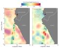
|
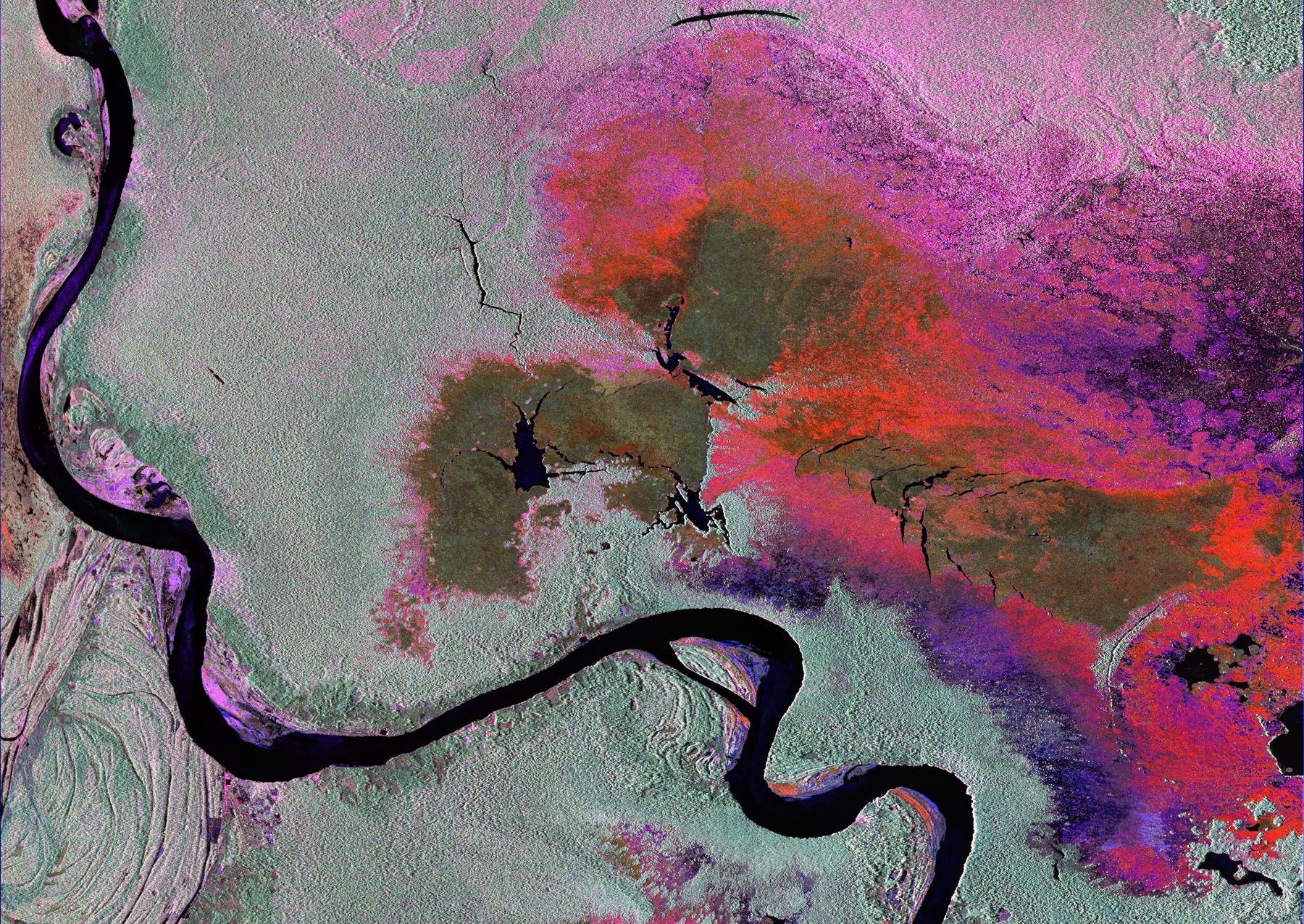
-
PIA26181:
-
SWOT Monitors El Niño off Peru
Full Resolution:
TIFF
(1.206 MB)
JPEG
(101.7 kB)
|
|
|
2023-11-03 |
Earth
|
Terra
|
ASTER
|
3000x1800x3 |
|
-
PIA26196:
-
Amazon Drought
Full Resolution:
TIFF
(16.21 MB)
JPEG
(799.4 kB)
|
|
|
2023-10-30 |
Earth
|
SWOT
|
KaRIn
|
1920x1080x3 |

|
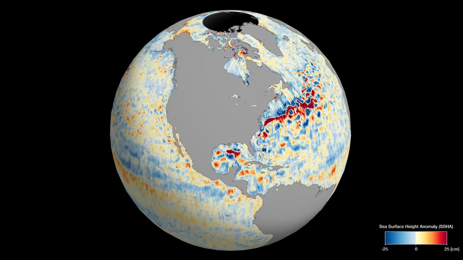
-
PIA26100:
-
SWOT's Detailed View of Global Sea Level
Full Resolution:
TIFF
(2.393 MB)
JPEG
(137.4 kB)
|
|
|
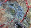
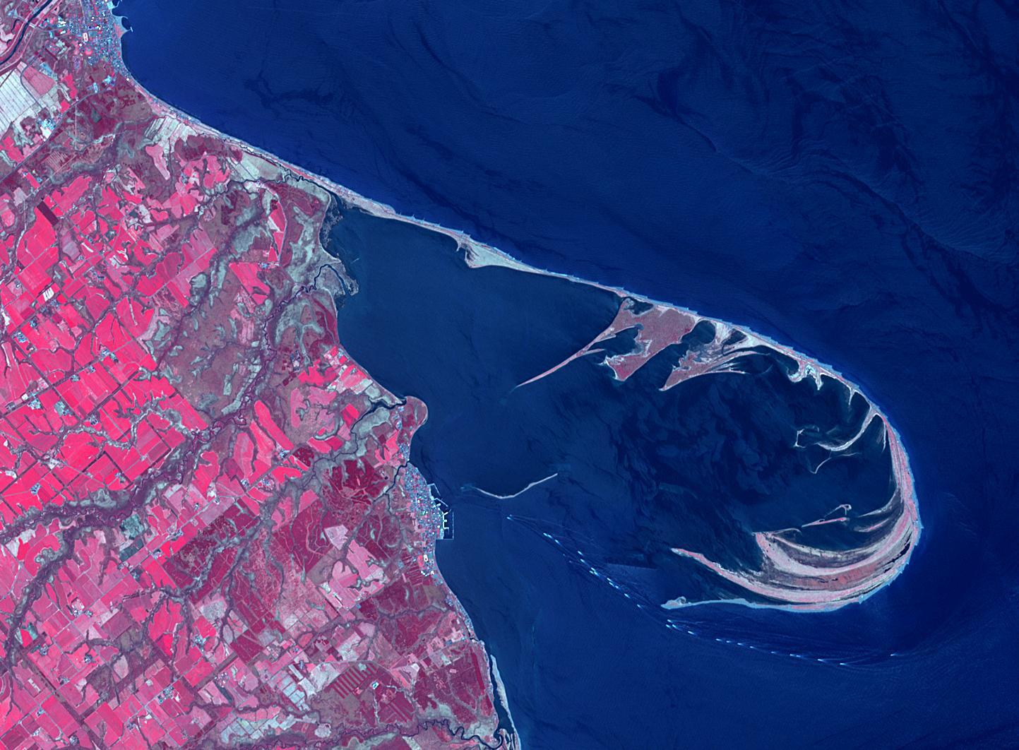
2023-10-27 |
Earth
|
NISAR
|
|
1800x1275x3 |
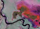
|
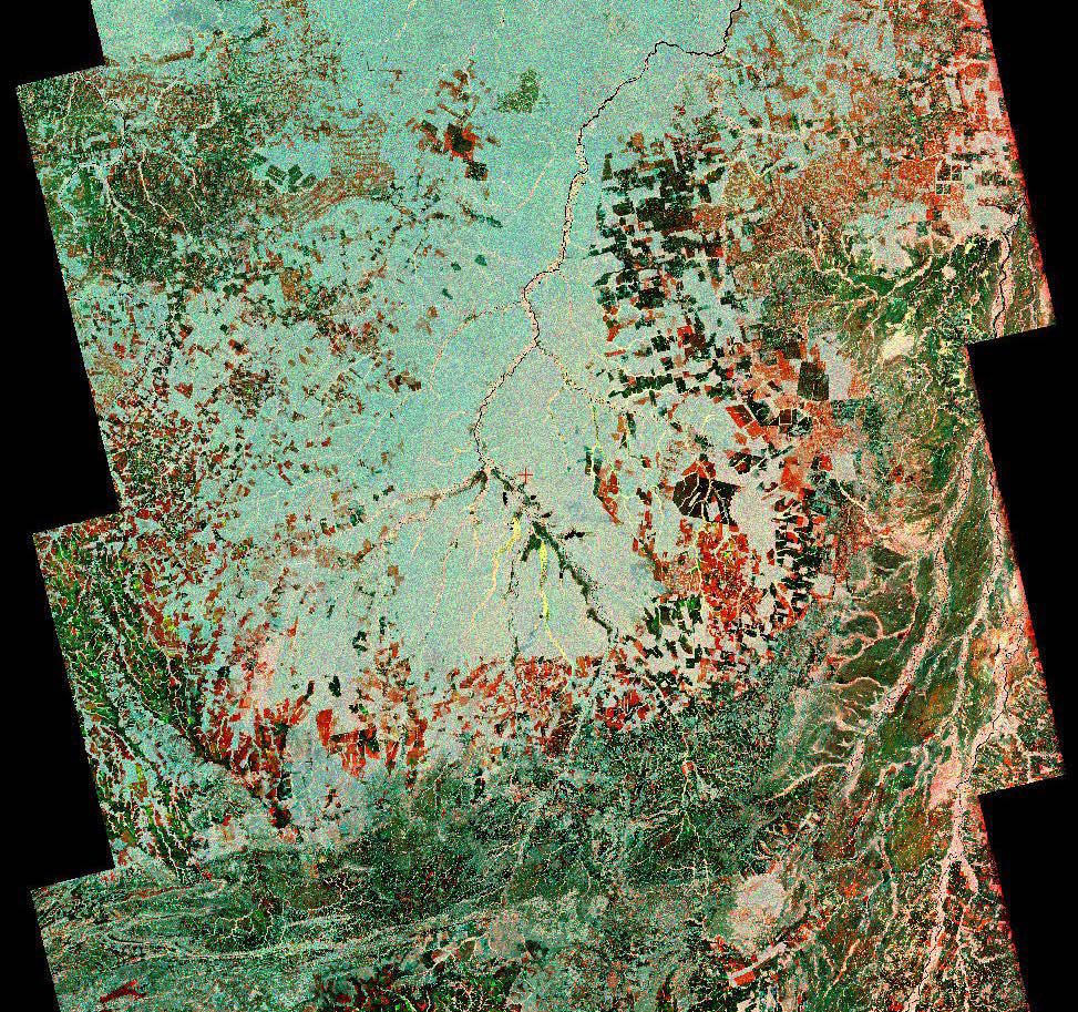
-
PIA26112:
-
Radar Image of Amazonian Flooding Similar to Future NISAR Imagery
Full Resolution:
TIFF
(6.888 MB)
JPEG
(808.4 kB)
|
|
|
2023-10-27 |
Earth
|
NISAR
|
|
973x913x3 |
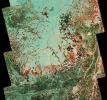
|
-
PIA26111:
-
Composite of Brazil's 'Arc of Deforestation' Shows Imagery NISAR Will Produce
Full Resolution:
TIFF
(2.666 MB)
JPEG
(396.6 kB)
|
|
|
2023-10-26 |
Mars
|
|
|
2852x1169x3 |
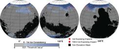
|
-
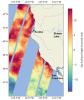
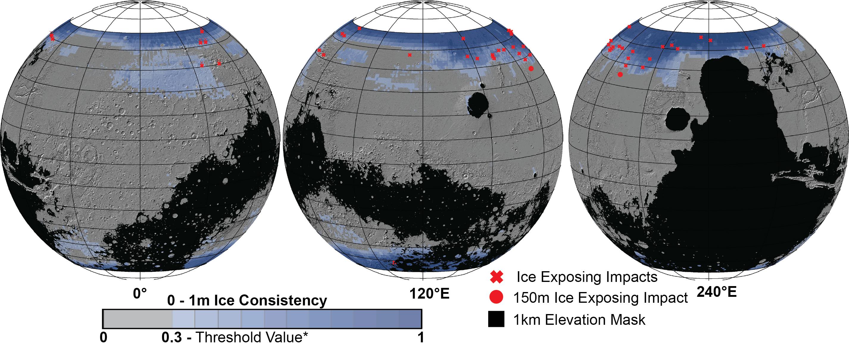
PIA26046:
-
Distribution of Buried Ice on Mars
Full Resolution:
TIFF
(3.622 MB)
JPEG
(582.8 kB)
|
|
|
2023-10-26 |
Mars
|
|
|
2221x1288x3 |
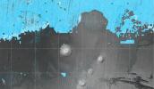
|
-
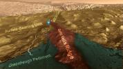
PIA26045:
-
SWIM Map Shows Subsurface Water Ice on Mars
Full Resolution:
TIFF
(6.232 MB)
JPEG
(404 kB)
|
|
|
2023-10-26 |
Mars
|
Mars Reconnaissance Orbiter (MRO)
|
HiRISE
|
2105x1139x3 |
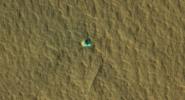
|
-
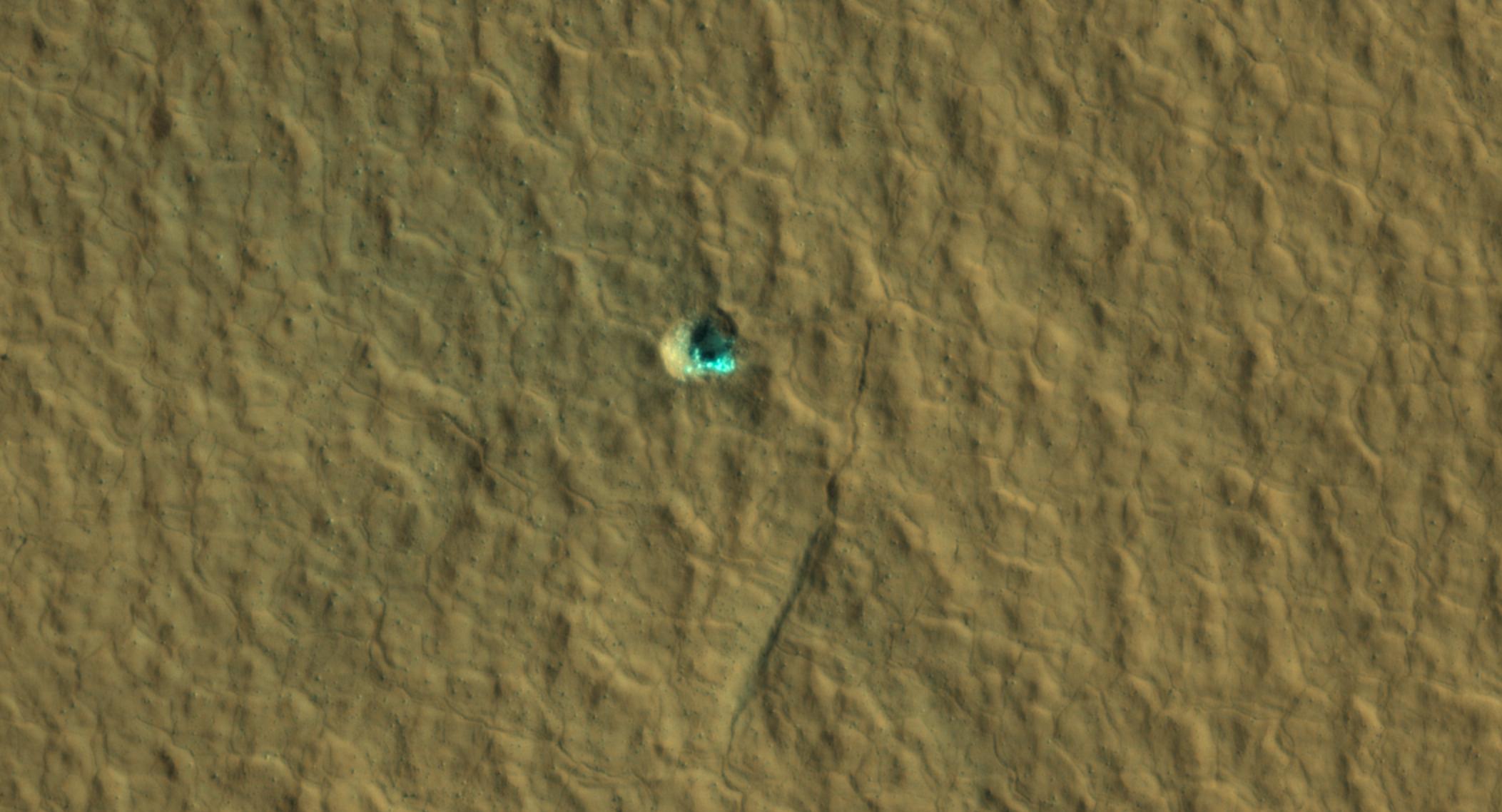
PIA26044:
-
Ice-Exposing Impact Crater Surrounded by Polygon Terrain
Full Resolution:
TIFF
(5.674 MB)
JPEG
(206.9 kB)
|
|
|
2023-10-18 |
Earth
|
Sentinel-6/Jason-CS
|
|
1586x783x3 |
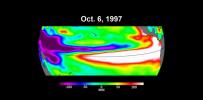
|
-
PIA26099:
-
Comparing Sea Level During El Niño Events
Full Resolution:
TIFF
(303.4 kB)
JPEG
(200.3 kB)
|
|
|
2023-10-18 |
Earth
|
Terra
|
ASTER
|
1528x1825x3 |
|
-
PIA26009:
-
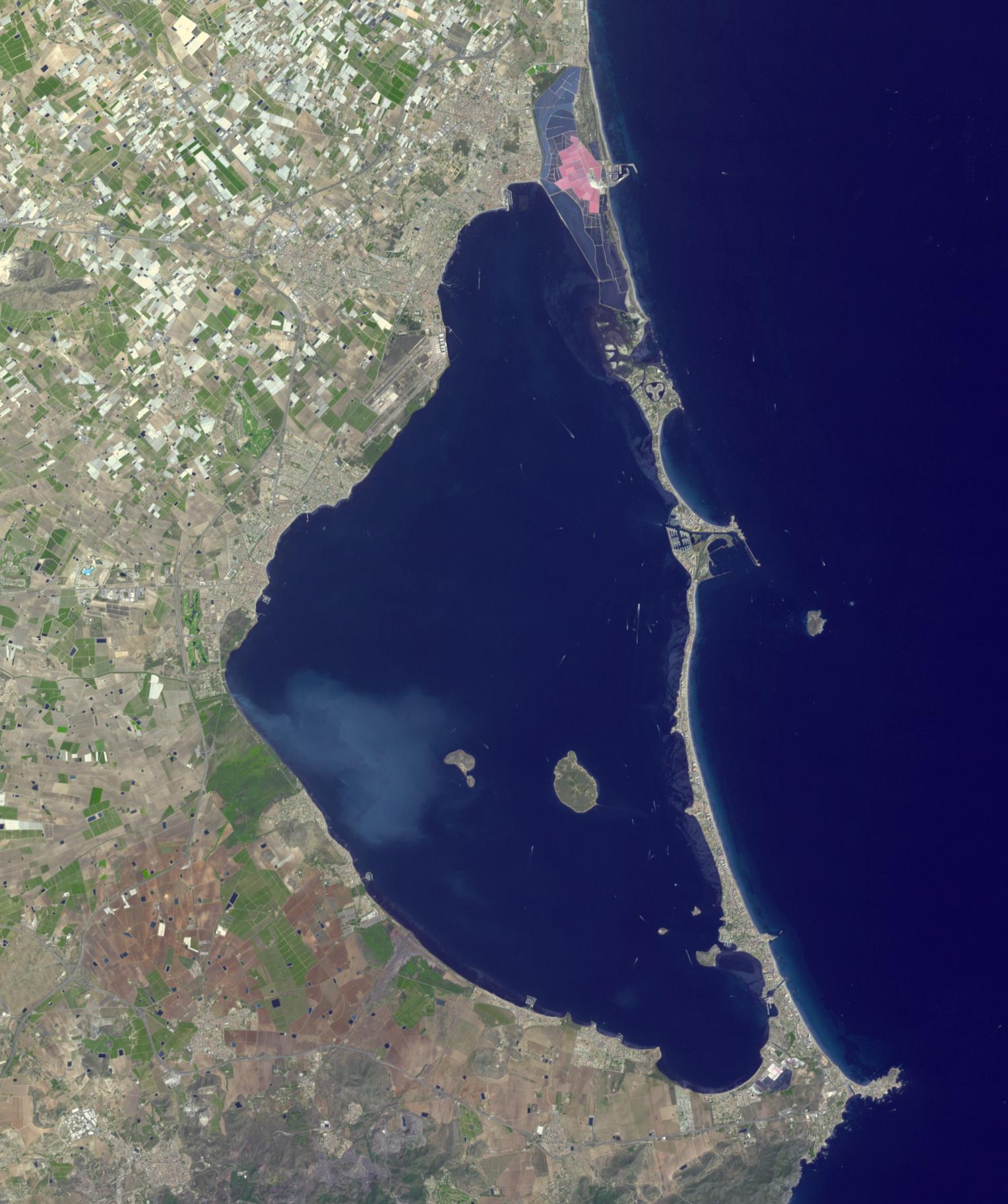
Mar Menor, Spain
Full Resolution:
TIFF
(6.95 MB)
JPEG
(304.1 kB)
|
|
|
2023-10-04 |
|
|
Deep Space Optical Communications (DSOC)
|
3000x2249x3 |

|
-
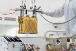
PIA26141:
-
DSOC's Superconducting Nanowire Single Photon Detector
Full Resolution:
TIFF
(20.25 MB)
JPEG
(1.132 MB)
|
|
|
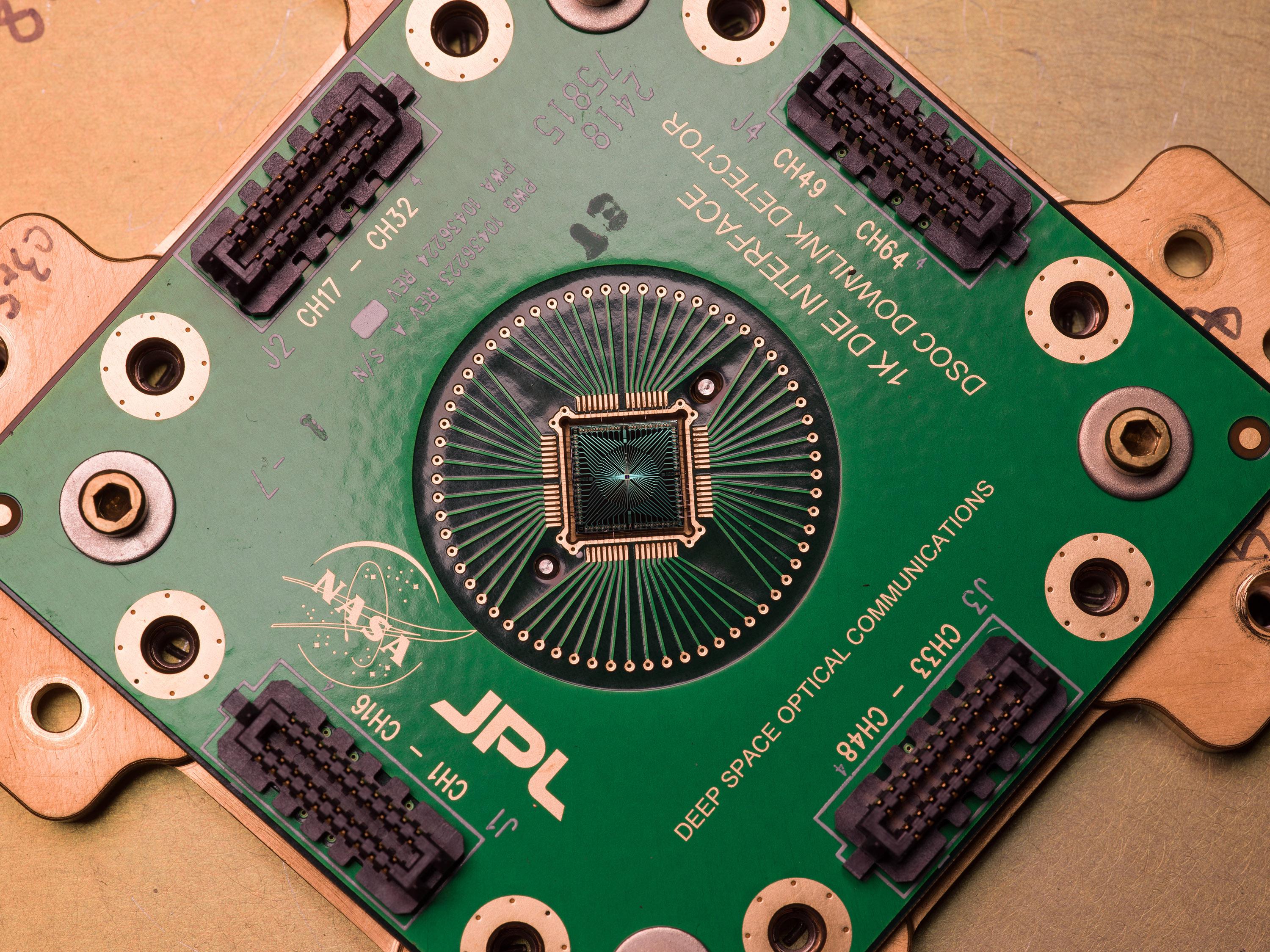
2023-10-04 |
|
|
Deep Space Optical Communications (DSOC)
|
3000x2003x3 |

|
-
PIA25840:
-
DSOC's Downlink Detector Prototype
Full Resolution:
TIFF
(18.04 MB)
JPEG
(951.1 kB)
|
|
|
2023-09-29 |
Mars
|
Mars 2020 Rover
|
Navigation Camera (M2020)
|
1280x240x1 |
|
-
PIA26074:
Martian Whirlwind Takes the 'Thorofare'
Full Resolution:
TIFF
(307.7 kB)
JPEG
(60.85 kB)
|
|
|
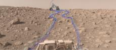
2023-09-21 |
Mars
|
Mars 2020 Rover
|
|
1488x872x3 |

|
-
PIA26073:
-
Perseverance AutoNav Avoids a Boulder
Full Resolution:
TIFF
(1.778 MB)
JPEG
(195.1 kB)
|
|
|
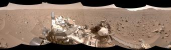
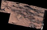
2023-09-21 |
Mars
|
Mars 2020 Rover
|
Navigation Camera (M2020)
|
8152x2396x3 |
|
-
PIA26072:
-
Perseverance Makes Tracks in Boulder Field
Full Resolution:
TIFF
(42.29 MB)
JPEG
(2.012 MB)
|
|
|
2023-09-21 |
Mars
|
Mars 2020 Rover
|
Navigation Camera (M2020)
|
2513x1095x3 |
|
-
PIA26071:
-
Perseverance's AutoNav Leads the Way
Full Resolution:
TIFF
(6.566 MB)
JPEG
(273.7 kB)
|
|
|
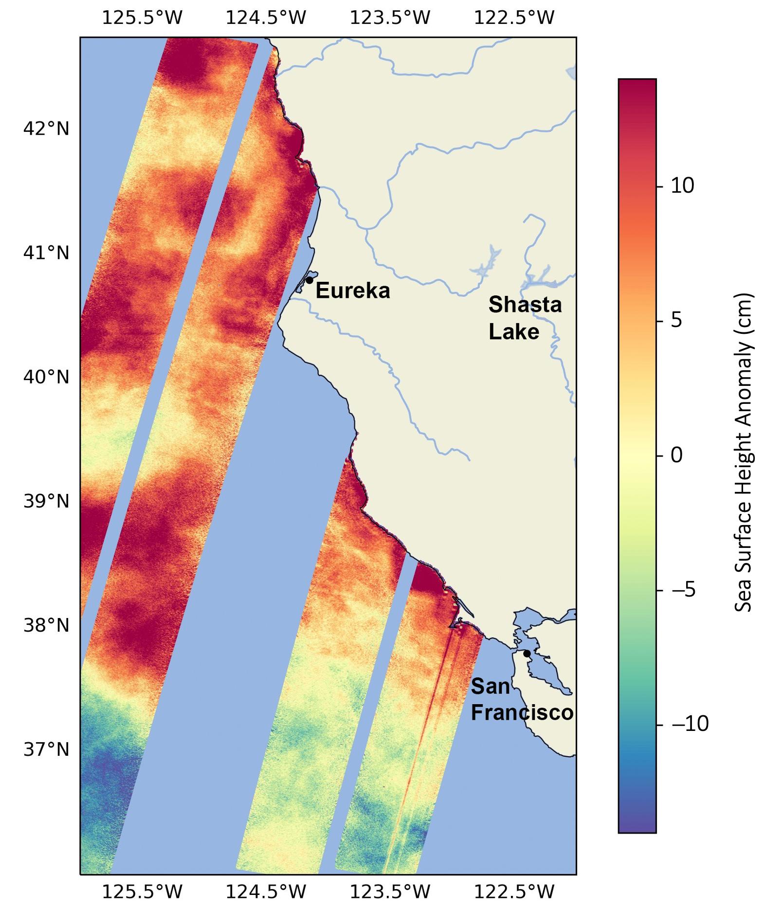
2023-09-19 |
Earth
|
SWOT
|
KaRIn
|
1570x1870x3 |
|
-
PIA26091:
-
SWOT Monitors Warming Waters Off California Coast
Full Resolution:
TIFF
(4.064 MB)
JPEG
(286.6 kB)
|
|
|
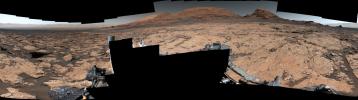
2023-09-18 |
Mars
|
Mars Science Laboratory (MSL)
|
|
1280x720x3 |
|
-
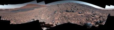
PIA26042:
-
Curiosity's Path to Gediz Vallis Ridge and Beyond
Full Resolution:
TIFF
(2.571 MB)
JPEG
(183.2 kB)
|
|
|
2023-09-18 |
Mars
|
Mars Science Laboratory (MSL)
|
Mastcam
|
9000x2394x3 |
|
-
PIA26019:
Curiosity Views Gediz Vallis Ridge
Full Resolution:
TIFF
(48.14 MB)
JPEG
(4.548 MB)
|
|
|
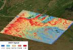
2023-09-14 |
|
Carbon Mapper
|
Carbon Mapper Imaging Spectrometer
|
909x660x3 |
|
-
PIA26095:
-
Methane Signal From Carbon Mapper Instrument Test
Full Resolution:
TIFF
(60.39 kB)
JPEG
(17.99 kB)
|
|
|
2023-09-14 |
Mars
|
2001 Mars Odyssey
|
THEMIS
|
600x2707x3 |
|
-
PIA26129:
-
Arsia Mons Flank - False Color
Full Resolution:
TIFF
(2.182 MB)
JPEG
(131.2 kB)
|
|
|
2023-09-11 |
Earth
|
Terra
|
ASTER
|
3257x2677x3 |
|
-
PIA26008:
-
Channeled Scablands, Washington
Full Resolution:
TIFF
(26.17 MB)
JPEG
(1.811 MB)
|
|
|
2023-09-06 |
Mars
|
Mars 2020 Rover
|
SuperCam
|
794x530x3 |
|
-
PIA26041:
-
The Sound of MOXIE at Work on Mars
Full Resolution:
TIFF
(977.4 kB)
JPEG
(48.52 kB)
|
|
|
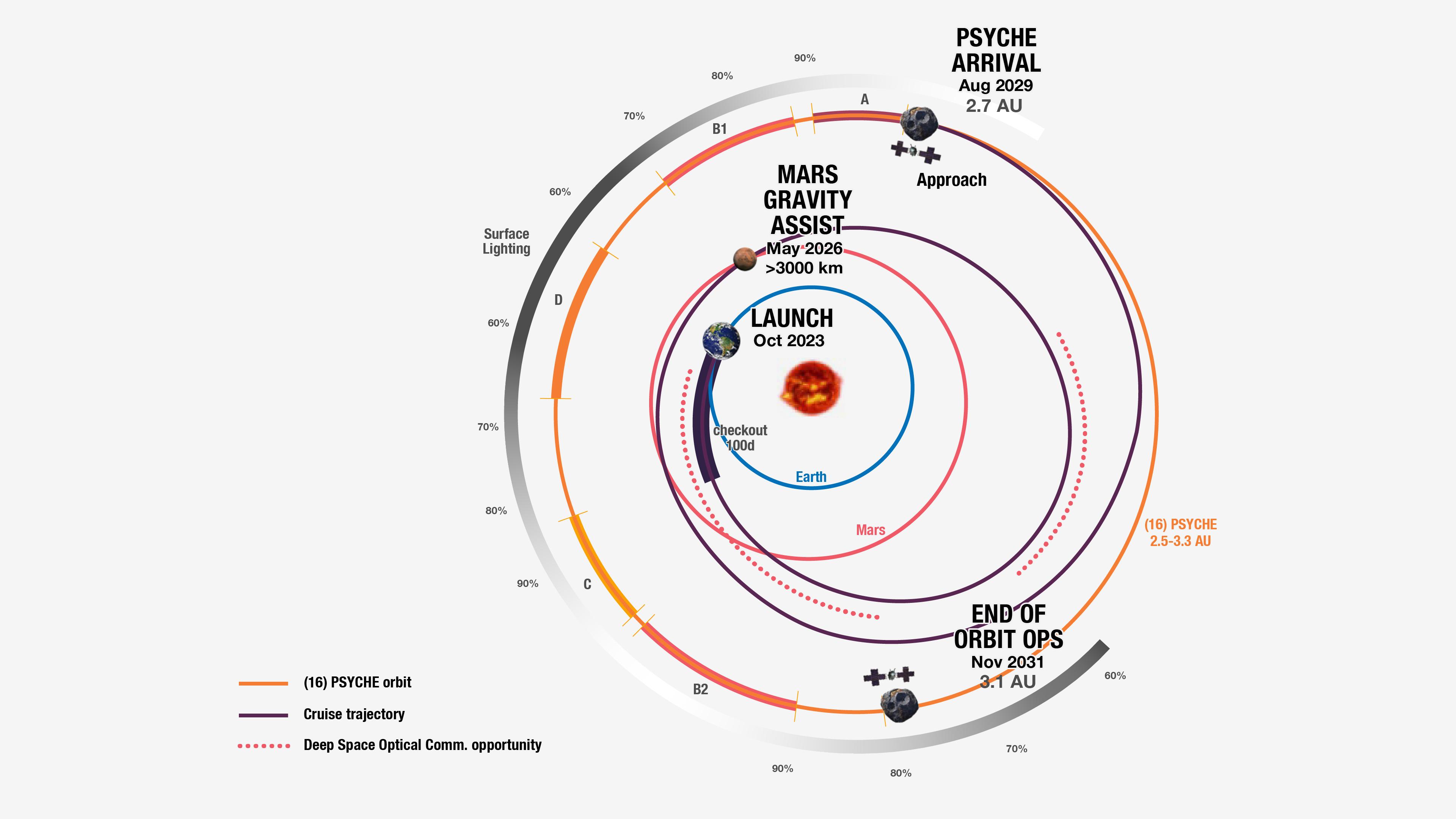
2023-09-01 |
|
Psyche
|
|
3840x2160x3 |
|
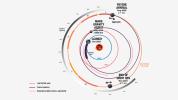
-
PIA24930:
-
Psyche's Mission Plan
Full Resolution:
TIFF
(1.804 MB)
JPEG
(352.6 kB)
|
|
|
2023-08-31 |
Mars
|
Mars 2020 Rover
|
Mastcam-Z
|
9000x819x3 |

|
-
PIA25965:
Perseverance Rover Looks West
Full Resolution:
TIFF
(13.43 MB)
JPEG
(613.3 kB)
|
|
|
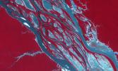
2023-08-30 |
Earth
|
Surface Water and Ocean Topography (SWOT)
|
KaRIn
|
2794x1934x3 |
|
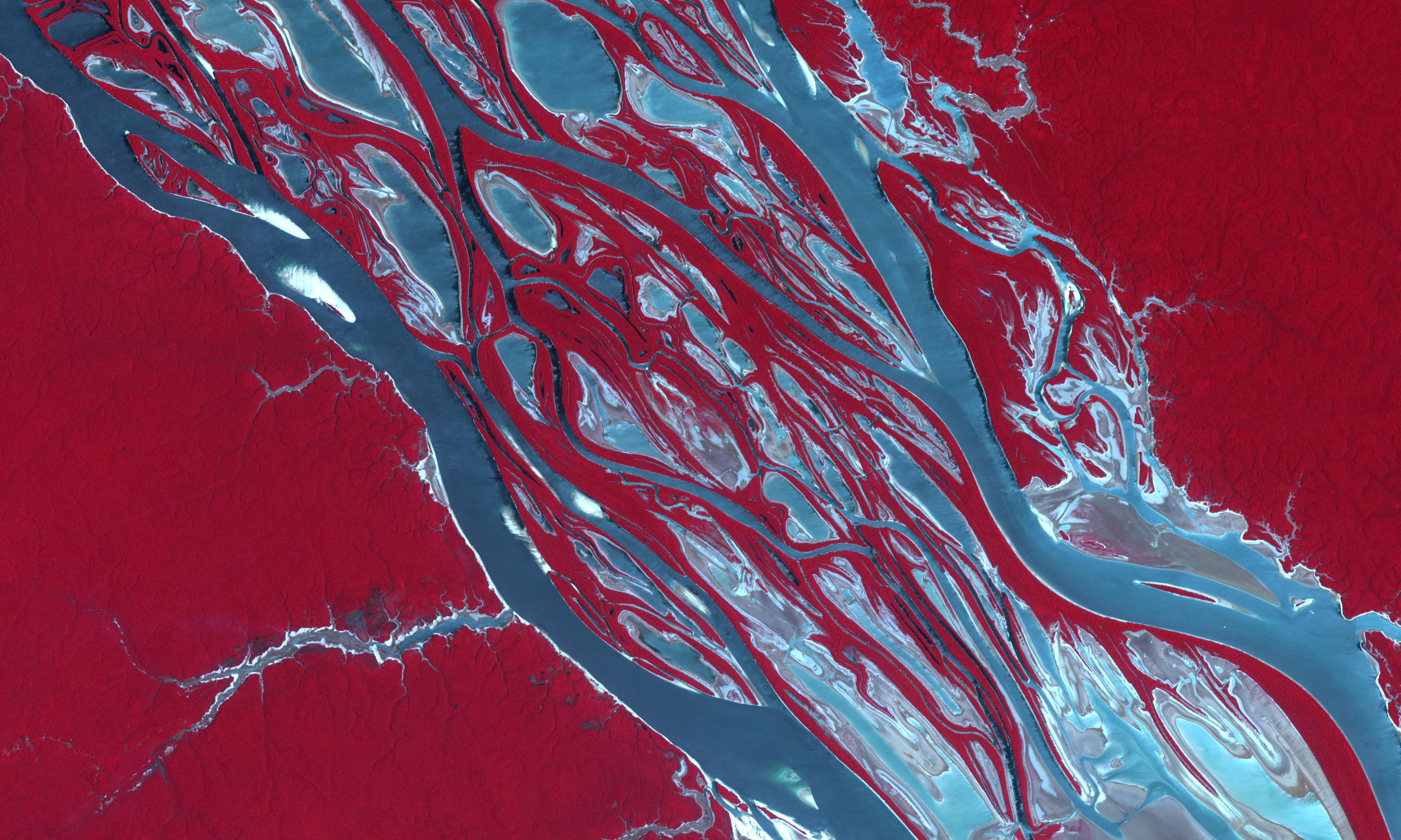
-
PIA25780:
-
SWOT Captures the Yukon River in Alaska
Full Resolution:
TIFF
(16.22 MB)
JPEG
(1.293 MB)
|
|
|
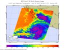
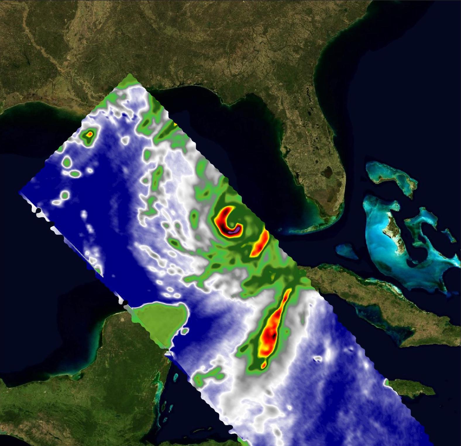
2023-08-29 |
Earth
|
COWVR
|
COWVR
TEMPEST
|
1606x1527x3 |

|
-
PIA25870:
-
COWVR, TEMPEST Capture Vital Data on Hurricane Franklin
Full Resolution:
TIFF
(3.924 MB)
JPEG
(155.7 kB)
|
|
|
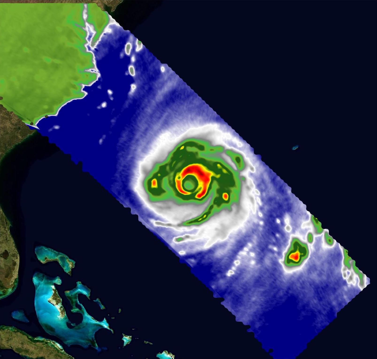
2023-08-29 |
Earth
|
COWVR
|
COWVR
TEMPEST
|
1576x1527x3 |
|
-
PIA25569:
-
COWVR, TEMPEST Capture Vital Data on Hurricane Idalia
Full Resolution:
TIFF
(5.962 MB)
JPEG
(250.3 kB)
|
|
|
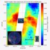
2023-08-24 |
|
Carbon Mapper Coalition
|
Carbon Mapper Imaging Spectrometer
|
8256x5504x3 |

|
-
PIA25869:
-
JPL Engineers Work on Carbon Mapper Imaging Spectrometer
Full Resolution:
TIFF
(110.5 MB)
JPEG
(6.681 MB)
|
|
|
2023-08-18 |
Earth
|
Aqua
|
AIRS
|
900x695x3 |
|
-
PIA25779:
-
Hurricane Hilary Captured by NASA's AIRS
Full Resolution:
TIFF
(817.3 kB)
JPEG
(107.8 kB)
|
|
|
2023-08-18 |
Mars
|
Mars Reconnaissance Orbiter (MRO)
|
HiRISE
|
2880x1800x3 |

|
-
PIA25984:
-
Icy Flows
Full Resolution:
TIFF
(8.293 MB)
JPEG
(1.169 MB)
|
|
|
2023-08-17 |
Earth
|
Terra
|
ASTER
|
2557x4344x3 |

|
-
PIA26007:
-
Sulawesi, Indonesia
Full Resolution:
TIFF
(24.91 MB)
JPEG
(1.094 MB)
|
|
|
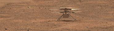
2023-08-16 |
Mars
|
Mars 2020 Rover
|
Mastcam-Z
|
1262x700x3 |
|
-
PIA25970:
-
Perseverance Rover Watches Ingenuity Mars Helicopter's 54th Flight
Full Resolution:
TIFF
(1.665 MB)
JPEG
(100.2 kB)
|
|
|
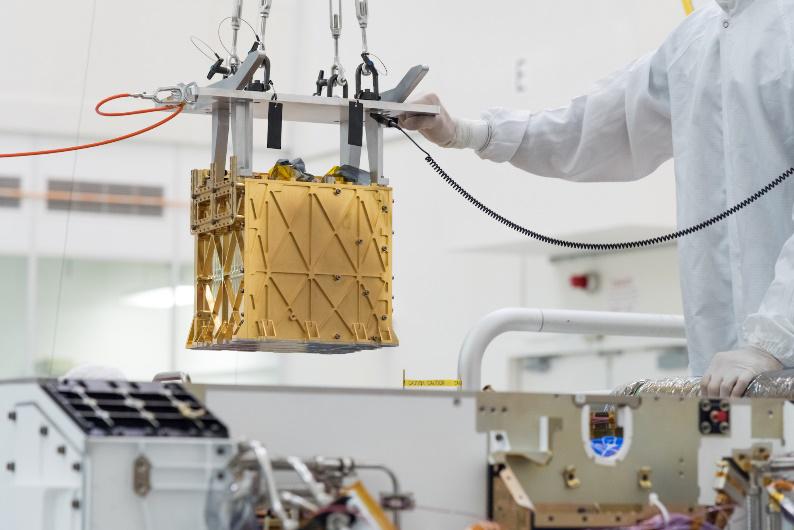
2023-08-15 |
Europa
|
Europa Clipper
|
|
7959x5306x3 |
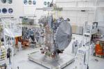
|
-
PIA25958:
-
Powerful Antenna Installed On Europa Clipper
Full Resolution:
TIFF
(100.3 MB)
JPEG
(5.174 MB)
|
|
|
2023-08-15 |
Europa
|
Europa Clipper
|
|
8272x6200x3 |
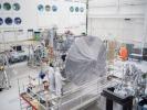
|
-
PIA25957:
-
Europa Clipper's High-Gain Antenna Installed
Full Resolution:
TIFF
(122.1 MB)
JPEG
(4.813 MB)
|
|
|
2023-08-15 |
Europa
|
Europa Clipper
|
|
4215x5623x3 |
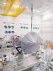
|
-
PIA25956:
-
Europa Clipper Gets Its High-Gain On
Full Resolution:
TIFF
(55.95 MB)
JPEG
(2.381 MB)
|
|
|
2023-08-14 |
Earth
|
Polar Radiant Energy in the Far-InfraRed Experiment (PREFIRE)
|
|
1920x1080x3 |
|
-
PIA25778:
-
PREFIRE Satellite Illustration
Full Resolution:
TIFF
(3.12 MB)
JPEG
(92.14 kB)
|
|
|
2023-08-10 |
Mars
|
Mars Sample Return (MSR)
|
|
1920x1080x3 |
|
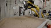
-
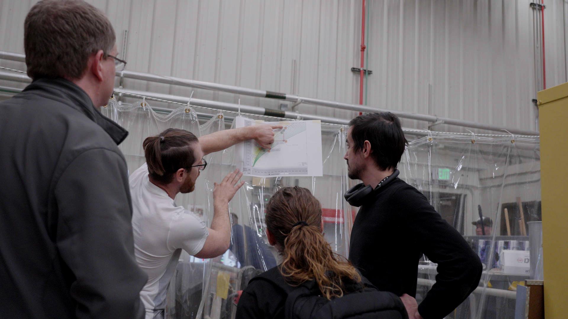
PIA25826:
-
Going Over the Footpad Test Data
Full Resolution:
TIFF
(4.761 MB)
JPEG
(161.3 kB)
|
|
|
2023-08-10 |
Mars
|
Mars Sample Return (MSR)
|
|
1920x1080x3 |
|
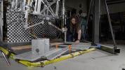
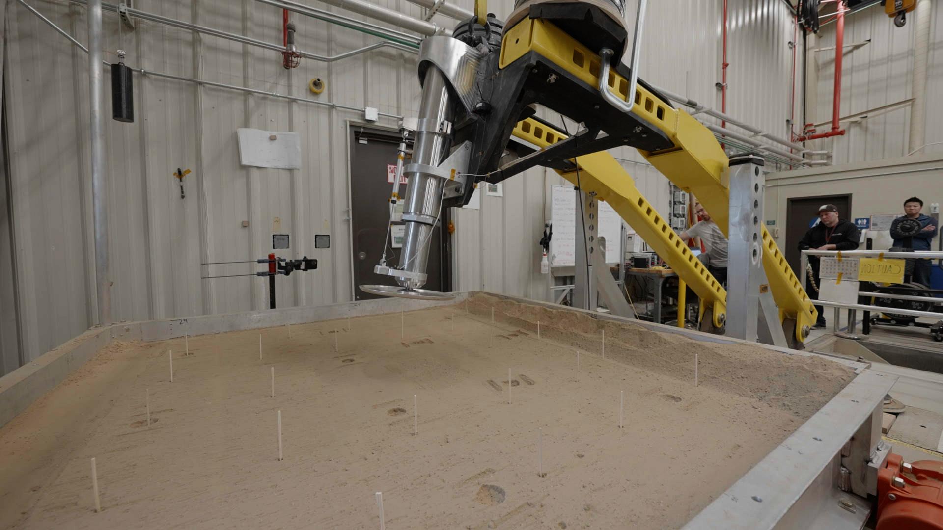
-
PIA25824:
-
A Full-Size Footpad Test
Full Resolution:
TIFF
(4.517 MB)
JPEG
(191.2 kB)
|
|
|
2023-08-10 |
Mars
|
Mars Sample Return (MSR)
|
|
1920x1080x3 |
|
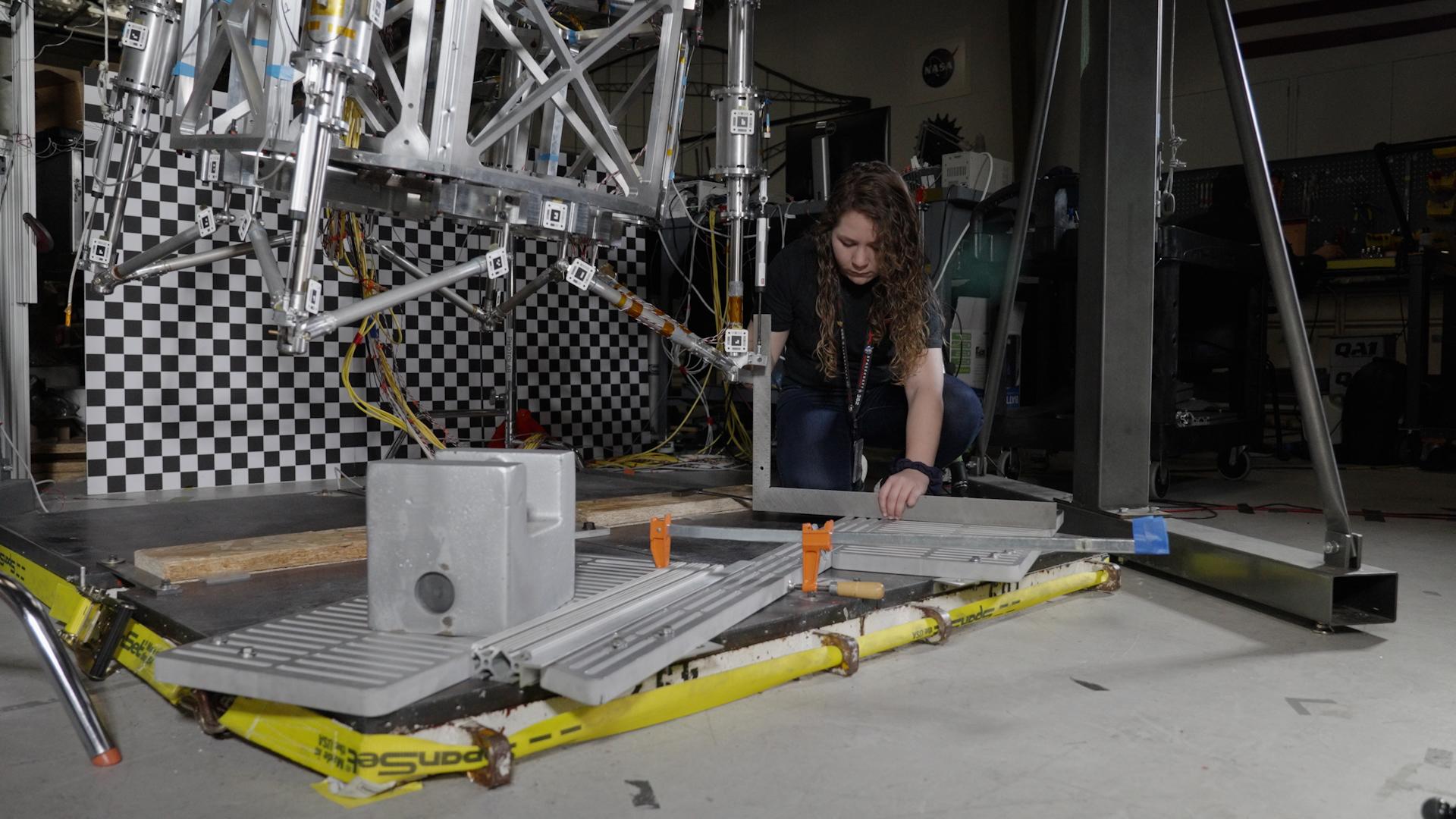
-
PIA25823:
-
Setting Guardrails for Mars Lander Testing
Full Resolution:
TIFF
(5.194 MB)
JPEG
(249.2 kB)
|
|
|
2023-08-10 |
Mars
|
Mars Sample Return (MSR)
|
|
3840x2160x3 |
|
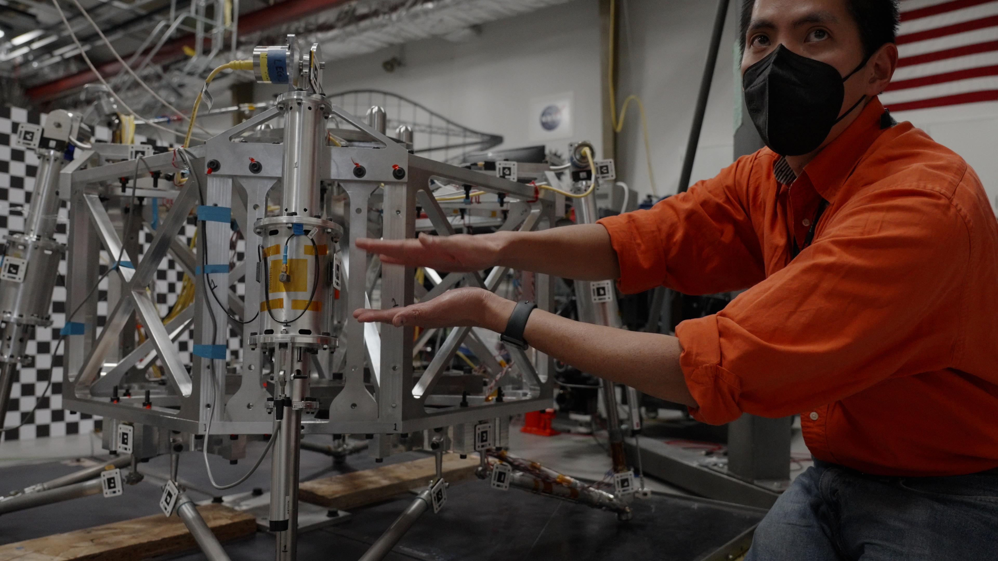
-
PIA25822:
-
Testing a Prototype Mars Lander
Full Resolution:
TIFF
(20.42 MB)
JPEG
(665 kB)
|
|
|
2023-08-09 |
Mars
|
Mars Science Laboratory (MSL)
|
Mastcam
|
29163x8162x3 |
|
-
PIA25915:
Curiosity Views Mud Cracks in the Clay-Sulfate Transition Region
Full Resolution:
TIFF
(476.1 MB)
JPEG
(31.49 MB)
|
|
|
2023-08-09 |
Mars
|
2001 Mars Odyssey
|
THEMIS
|
603x2701x1 |
|
-
PIA26053:
-
Ascraeus Mons
Full Resolution:
TIFF
(757.3 kB)
JPEG
(103.1 kB)
|
|
|
2023-08-08 |
Earth
|
Terra
|
ASTER
|
318x313x3 |
|
-
PIA26006:
-
Hunga Tonga-Hunga Ha'apai Eruption
Full Resolution:
TIFF
(170 kB)
JPEG
(9.253 kB)
|
|
|
2023-08-08 |
Earth
|
Suomi NPP
|
VIIRS
|
1200x675x3 |

|
-
PIA25868:
-
Phoenix Land-Surface Temperatures Documented Amid Record Heat
Full Resolution:
TIFF
(2.431 MB)
JPEG
(160.2 kB)
|
|
|
2023-08-07 |
Mars
|
Mars 2020 Rover
|
Mastcam-Z
|
4160x1127x3 |
|
-
PIA25968:
Perseverance Checks Out Ingenuity
Full Resolution:
TIFF
(14.07 MB)
JPEG
(988.6 kB)
|
|
|
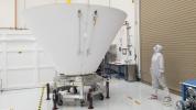
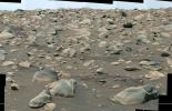
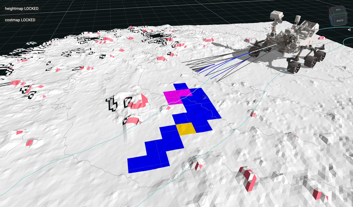
2023-08-03 |
|
Mars Sample Return (MSR)
|
|
3840x2160x3 |

|
-
PIA25986:
-
Artist's Concept of the Earth Entry System for Mars Sample Return
Full Resolution:
TIFF
(6.369 MB)
JPEG
(220.4 kB)
|
|
|
2023-08-03 |
Mars
|
Mars Science Laboratory (MSL)
|
Mastcam
|
5684x3174x3 |
|
-
PIA26013:
-
Curiosity's Attempted Climb up a Slope
Full Resolution:
TIFF
(54.15 MB)
JPEG
(5.622 MB)
|
|
|
2023-08-03 |
Mars
|
Mars Science Laboratory (MSL)
|
Mastcam
|
9000x2584x3 |
|
-
PIA26012:
-
Curiosity's View up a Challenging Slope
Full Resolution:
TIFF
(48.08 MB)
JPEG
(4.328 MB)
|
|
|
2023-08-03 |
Mars
|
Mars Science Laboratory (MSL)
|
Mastcam
|
2892x1314x3 |
|
-
PIA26011:
-
Curiosity's View Back Toward 'Marker Band Valley'
Full Resolution:
TIFF
(11.1 MB)
JPEG
(1.224 MB)
|
|
|
2023-08-03 |
Mars
|
Mars Science Laboratory (MSL)
|
Mastcam
|
4617x2950x3 |
|
-
PIA25920:
-
Curiosity's Climb Attempt Leaves Tracks
Full Resolution:
TIFF
(30.24 MB)
JPEG
(2.791 MB)
|
|
|
2023-08-03 |
Mars
|
Mars Science Laboratory (MSL)
|
Mastcam
|
9000x2641x3 |
|
-
PIA26014:
-
Curiosity Views a Crater at 'Jau'
Full Resolution:
TIFF
(45.85 MB)
JPEG
(3.742 MB)
|
|
|
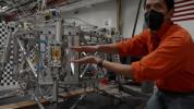
2023-08-02 |
|
Cooperative Autonomous Distributed Robotic Exploration (CADRE)
|
|
2000x2406x3 |
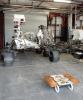
|
-
PIA25668:
-
Test Rovers Big and Small at JPL
Full Resolution:
TIFF
(12.97 MB)
JPEG
(743.9 kB)
|
|
|
2023-07-31 |
|
Mars Sample Return (MSR)
|
|
1872x1053x3 |
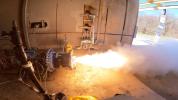
|
-
PIA25967:
-
Mars Ascent Vehicle Second Stage Test
Full Resolution:
TIFF
(5.916 MB)
JPEG
(285.5 kB)
|
|
|
2023-07-19 |
Mars
|
Mars 2020 Rover
|
Mastcam-Z
|
7400x4784x3 |
|
-
PIA25963:
-
Perseverance Views Jezero Boulder Field
Full Resolution:
TIFF
(104.1 MB)
JPEG
(5.348 MB)
|
|
|
2023-07-19 |
Mars
|
Mars 2020 Rover
|
|
1100x1100x3 |
|
-
PIA25962:
-
Perseverance's 'Otis Peak' Sample Reveals Colors of Conglomerate
Full Resolution:
TIFF
(3.631 MB)
JPEG
(225.8 kB)
|
|
|
2023-07-18 |
Earth
|
Terra
|
ASTER
|
4000x3303x3 |
|
-
PIA25981:
-
Democratic Republic of Sao Tome and Principe
Full Resolution:
TIFF
(27.66 MB)
JPEG
(1.153 MB)
|
|
|
2023-07-14 |
Mars
|
2001 Mars Odyssey
|
THEMIS
|
601x2706x1 |

|
-
PIA26025:
-
Oti Fossae
Full Resolution:
TIFF
(770.8 kB)
JPEG
(115 kB)
|
|
|
2023-07-13 |
|
NISAR
|
L-Band Synthetic Aperture Radar
S-Band Synthetic Aperture Radar
|
2000x1244x3 |
|
-
PIA25867:
-
U.S.-Indian Team Collaborates to Assemble Main Components of NISAR
Full Resolution:
TIFF
(6.331 MB)
JPEG
(397.9 kB)
|
|
|
2023-07-13 |
|
NISAR
|
L-Band Synthetic Aperture Radar
S-Band Synthetic Aperture Radar
|
2000x2901x3 |
|
-
PIA25866:
-
NISAR Satellite's Major Components Come Together
Full Resolution:
TIFF
(11.66 MB)
JPEG
(690.3 kB)
|
|
|
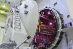
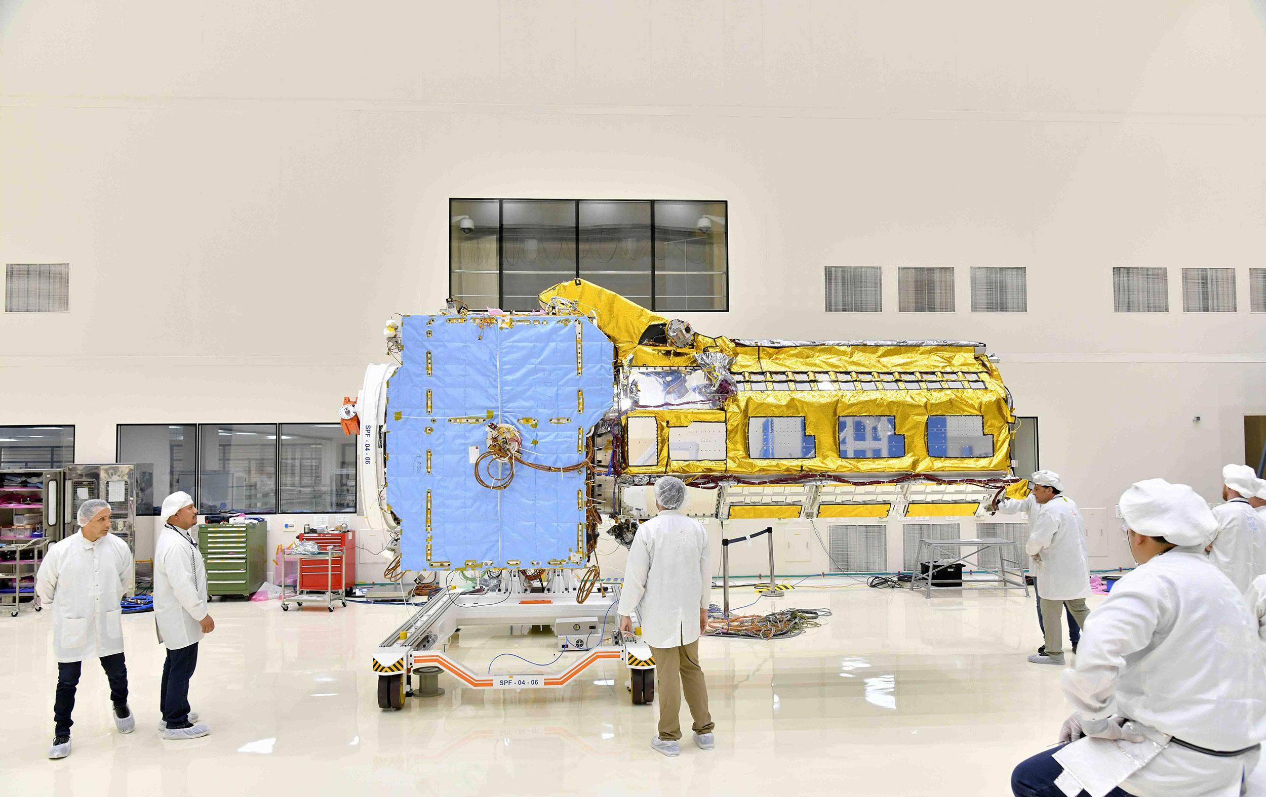
2023-07-13 |
|
NISAR
|
L-Band Synthetic Aperture Radar
S-Band Synthetic Aperture Radar
|
2500x1575x3 |
|
-
PIA25865:
-
Main Components of NISAR Satellite Joined
Full Resolution:
TIFF
(6.871 MB)
JPEG
(444.3 kB)
|
|
|
2023-07-12 |
Mars
|
Mars 2020 Rover
|
Scanning Habitable Environments with Raman & Luminescence for Organics and Chemicals (SHERLOC)
|
1799x1337x3 |
|
-
PIA25919:
-
Perseverance Rover's SHERLOC Studies 'Quartier'
Full Resolution:
TIFF
(7.219 MB)
JPEG
(443.5 kB)
|
|
|
2023-07-10 |
Mars
|
2001 Mars Odyssey
|
THEMIS
|
602x2692x1 |
|
-
PIA26021:
-
Ascraeus Mons Summit
Full Resolution:
TIFF
(760.2 kB)
JPEG
(111.8 kB)
|
|
|
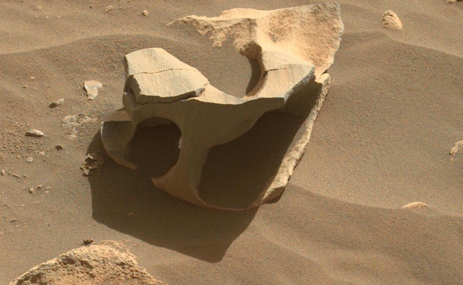
2023-06-29 |
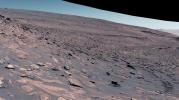
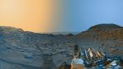
Mars
|
Mars 2020 Rover
|
Mastcam-Z
|
1906x1174x3 |
|
-
PIA25917:
-
Perseverance Finds a Hollowed-Out Rock
Full Resolution:
TIFF
(6.716 MB)
JPEG
(285.3 kB)
|
|
|
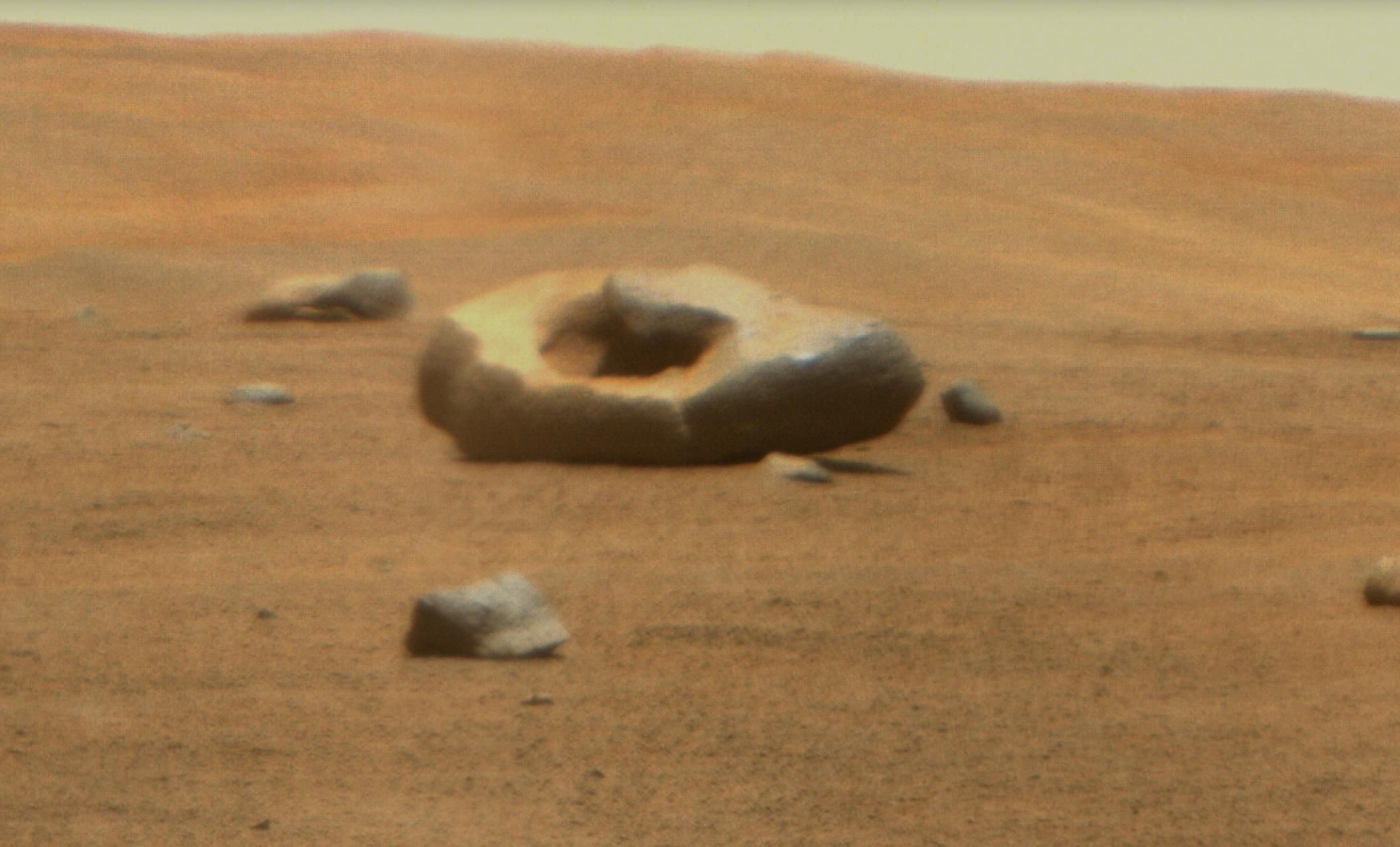
2023-06-29 |
Mars
|
Mars 2020 Rover
|
SuperCam
|
2106x1274x3 |
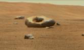
|
-
PIA25916:
-
Perseverance Discovers a Doughnut-Shaped Rock
Full Resolution:
TIFF
(6.335 MB)
JPEG
(217.4 kB)
|
|
|
2023-06-27 |
Earth
|
Surface Water and Ocean Topography (SWOT)
|
|
1125x1122x3 |
|
-
PIA25777:
-
SWOT Measures Tuvalu Sea Level
Full Resolution:
TIFF
(1.862 MB)
JPEG
(131.7 kB)
|
|
|
2023-06-22 |
Earth
|
Terra
|
|
2741x2514x3 |
|
-
PIA25946:
-
Folded Rocks, Iran
Full Resolution:
TIFF
(20.68 MB)
JPEG
(1.742 MB)
|
|
|
2023-06-15 |
Jupiter
|
Juno
|
JunoCam
|
1024x1024x3 |
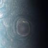
|
-
PIA25020:
-
NASA's Juno Mission Captures Lightning On Jupiter
Full Resolution:
TIFF
(2.79 MB)
JPEG
(63.74 kB)
|
|
|
2023-06-13 |
Mars
|
Mars Science Laboratory (MSL)
|
Navigation Camera (M2020)
|
3840x2160x3 |
|
-
PIA25912:
-
Curiosity's 'Postcard' of 'Marker Band Valley'
Full Resolution:
TIFF
(19.22 MB)
JPEG
(666.5 kB)
|
|
|
2023-06-08 |
Mars
|
Mars Science Laboratory (MSL)
|
|
13200x10200x3 |
|
-
PIA25914:
-
Curiosity's Quadrant Themes
Full Resolution:
TIFF
(147.4 MB)
JPEG
(15.53 MB)
|
|
|
2023-06-08 |
Mars
|
Mars 2020 Rover
|
|
12000x12000x3 |
|
-
PIA25913:
-
Perseverance's Quadrant Themes
Full Resolution:
TIFF
(422.3 MB)
JPEG
(24.42 MB)
|
|
|
2023-06-06 |
Mars
|
2001 Mars Odyssey
|
THEMIS
|
609x2701x1 |
|
-
PIA25972:
-
Ascraeus Mons
Full Resolution:
TIFF
(774.6 kB)
JPEG
(94.43 kB)
|
|
|
2023-06-01 |
Earth
|
Terra
|
ASTER
|
1400x1176x3 |

|
-
PIA25896:
-
Najaf, Iraq
Full Resolution:
TIFF
(4.91 MB)
JPEG
(251.8 kB)
|
|
|
2023-05-25 |
Earth
|
Terra
|
ASTER
|
1413x1143x3 |
|
-
PIA25895:
-
Heilongjiang Province, China
Full Resolution:
TIFF
(4.847 MB)
JPEG
(428.6 kB)
|
|
|
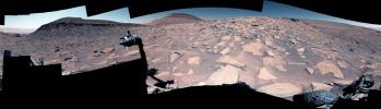
2023-05-18 |
Mars
|
Mars 2020 Rover
|
Mastcam-Z
|
9000x1191x3 |
|
-
PIA25889:
Perseverance Takes in View at Belva Crater
Full Resolution:
TIFF
(23.28 MB)
JPEG
(1.248 MB)
|
|
|
2023-05-15 |
Earth
|
|
|
1440x700x3 |

|
-
PIA25864:
-
Declining Methane Emissions at California Oil Fields and Refineries
Full Resolution:
TIFF
(325.1 kB)
JPEG
(73.03 kB)
|
|
|
2023-05-12 |
Mars
|
Mars Reconnaissance Orbiter (MRO)
|
HiRISE
|
2880x1800x3 |
|
-
PIA25948:
-
Complicated Lava Cooling
Full Resolution:
TIFF
(15.56 MB)
JPEG
(1.473 MB)
|
|
|
2023-05-12 |
Mars
|
Mars Reconnaissance Orbiter (MRO)
|
HiRISE
|
2880x1800x3 |
|
-
PIA25947:
-
Glacier-like Features on Mars
Full Resolution:
TIFF
(8.111 MB)
JPEG
(1.232 MB)
|
|
|
2023-05-12 |
Earth
|
Sentinel-6/Jason-CS
|
|
875x415x3 |
|
-
PIA25776:
-
Early El Niño Signs
Full Resolution:
TIFF
(598.3 kB)
JPEG
(51.43 kB)
|
|
|
2023-05-11 |
Mars
|
Mars 2020 Rover
|
Mastcam-Z
|
4345x2113x3 |
|
-
PIA25911:
-
Mastcam-Z's View of 'Franklin Cliffs'
Full Resolution:
TIFF
(18.86 MB)
JPEG
(964.2 kB)
|
|
|
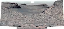
2023-05-11 |
Mars
|
Mars 2020 Rover
|
Mastcam-Z
|
8323x3435x3 |
|
-
PIA25830:
-
Mastcam-Z's View of 'Pinestand'
Full Resolution:
TIFF
(63.95 MB)
JPEG
(3.231 MB)
|
|
|
2023-05-11 |
Mars
|
Mars 2020 Rover
|
Mastcam-Z
|
9000x3083x3 |
|
-
PIA25829:
-
Curved Bands of Rocks at 'Skrinkle Haven'
Full Resolution:
TIFF
(51.01 MB)
JPEG
(3.842 MB)
|
|
|
2023-04-27 |
Earth
|
Terra
|
ASTER
|
1686x939x3 |

|
-
PIA25859:
-
Sark, English Channel Islands
Full Resolution:
TIFF
(4.4 MB)
JPEG
(264.4 kB)
|
|
|
2023-04-26 |
Asteroid
|
Deep Space Network (DSN)
|
Deep Space Network
|
2922x1411x1 |
|
-
PIA25834:
-
NASA's Planetary Radar Images Asteroid 2006 HV5
Full Resolution:
TIFF
(2.324 MB)
JPEG
(1.039 MB)
|
|
|
2023-04-20 |
Mars
|
Mars Sample Return (MSR)
|
|
3840x2160x3 |
|
-
PIA25860:
-
Illustration of the Capture, Containment, and Return System for Mars Sample Return
Full Resolution:
TIFF
(12.9 MB)
JPEG
(323.7 kB)
|
|
|
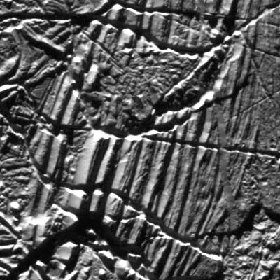
2023-04-14 |
Europa
|
Galileo
|
Solid-State Imaging
|
360x360x1 |
|
-
PIA25499:
-
Europa's Surface: Up-Close Topography
Full Resolution:
TIFF
(130 kB)
JPEG
(35.73 kB)
|
|
|
2023-04-14 |
Europa
|
Galileo
|
Solid-State Imaging
|
400x400x1 |
|
-
PIA25498:
-
Europa Close-Up
Full Resolution:
TIFF
(160.4 kB)
JPEG
(40.6 kB)
|
|
|
2023-04-12 |
Earth
|
Terra
|
ASTER
|
1443x1062x3 |
|
-
PIA25858:
-
Notsuke Peninsula, Japan
Full Resolution:
TIFF
(4.396 MB)
JPEG
(234.3 kB)
|
|
|
2023-04-12 |
|
VERITAS
|
VISAR
|
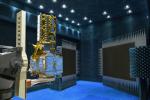
3000x2249x3 |
|
-
PIA25833:
-
International Collaboration for Early VERITAS Prototype Hardware Tests
Full Resolution:
TIFF
(17.97 MB)
JPEG
(905.4 kB)
|
 Planetary Data System


