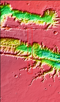
Context imageToday's VIS image shows part of Ius Chasma and one of its mega gullies (bottom of image). Ius Chasma is unique from the other chasmata of Valles Marineris in possessing mega gullies on both sides of the chasma. The largest mega gullies are located in Sinai Planum, dissecting those plains and emptying into the canyon. Mega gullies are thought to be sapping channels caused by groundwater flow and erosion. The Earth analog is springs – water that flows underground and then breaches the surface creating channels. The morphology of the Mars gullies mirrors terrestrial springs. The channel is fairly uniform in width and the "head" of the channel is rounded like an amphitheater. The channel lengthens by erosion at the "head" backwards as the surface where the spring emerges is undercut. For Mars it is theorized that subsurface water would stay liquid due to underground heating. Ius Chasma is at the western end of Valles Marineris, south of Tithonium Chasma. Valles Marineris is over 4000 kilometers long, almost as wide as the United States. Ius Chasma is almost 850 kilometers long (528 miles), 120 kilometers wide and over 8 kilometers deep.
Orbit Number: 91408 Latitude: -6.95449 Longitude: 274.37 Instrument: VIS Captured: 2022-07-23 20:09
Please see the THEMIS Data Citation Note for details on crediting THEMIS images.
NASA's Jet Propulsion Laboratory manages the 2001 Mars Odyssey mission for NASA's Science Mission Directorate, Washington, D.C. The Thermal Emission Imaging System (THEMIS) was developed by Arizona State University, Tempe, in collaboration with Raytheon Santa Barbara Remote Sensing. The THEMIS investigation is led by Dr. Philip Christensen at Arizona State University. Lockheed Martin Astronautics, Denver, is the prime contractor for the Odyssey project, and developed and built the orbiter. Mission operations are conducted jointly from Lockheed Martin and from JPL, a division of the California Institute of Technology in Pasadena.

 Planetary Data System


