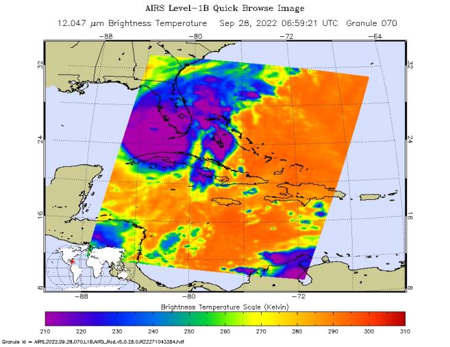
NASA's Atmospheric Infrared Sounder (AIRS) instrument aboard the Aqua satellite captured imagery of Hurricane Ian over the Gulf of Mexico between Cuba and Florida just before 2 a.m. local time Sept. 28, 2022. At that time, the Category 3 storm was in a period of rapid intensification – when a hurricane's wind speeds increase by 35 mph (56 kph) or more within 24 hours – while moving northward toward Florida after having recently made landfall over western Cuba.
The image shows cloud or surface temperature measurements taken at infrared wavelengths. The large purple area indicates very cold clouds at about minus 90 degrees Fahrenheit (minus 67 degrees Celsius, or around 210 Kelvin on the map's scale). These clouds are carried high into the atmosphere by tall thunderstorms and are associated with very heavy rainfall. Warmer areas with shallower rain clouds are shown in blue and green. The orange and red areas represent mostly cloud-free air. The eye of the hurricane is seen as a small blue area in the middle of the large purple patch.
AIRS, in conjunction with the Advanced Microwave Sounding Unit (AMSU), senses emitted infrared and microwave radiation from Earth to provide a 3D look at the planet's weather and climate. Working in tandem, the two instruments make simultaneous observations down to Earth's surface. With more than 2,000 channels sensing different regions of the atmosphere, the system creates a global, 3D map of atmospheric temperature and humidity, cloud amounts and heights, greenhouse gas concentrations, and many other atmospheric phenomena. Launched into Earth orbit in 2002 aboard NASA's Aqua spacecraft, the AIRS and AMSU instruments are managed by NASA's Jet Propulsion Laboratory in Southern California, under contract to NASA. JPL is a division of Caltech.
More information about AIRS can be found at https://airs.jpl.nasa.gov.