Produced with data from NASA's Earth Surface Mineral Dust Source Investigation (EMIT) mission, this image uses two different ways of displaying methane's unique pattern of absorbed infrared light – called a spectral fingerprint. This potent greenhouse gas is estimated to be 80 times more effective at trapping heat in the atmosphere than carbon dioxide.
EMIT uses an imaging spectrometer to detect the spectral fingerprints of various materials on Earth's surface and in its atmosphere. Installed on the International Space Station in July 2022, EMIT was originally intended to map the prevalence of minerals in Earth's arid regions, such as the deserts of Africa, Australia, and the Americas. Scientists verified that EMIT could also detect the spectral fingerprints of methane and carbon dioxide exceptionally well when they were checking the accuracy of the image spectrometer's mineral data.
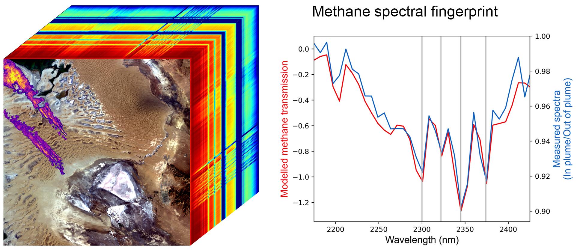
The left panel shows an EMIT data cube that spans an area of Turkmenistan roughly 2,500 square miles (6,400 square kilometers). The rainbow colors extending through the data cube represent the spectral fingerprints from each location within the scene at the front of the cube. The purple, orange, and yellow streaks shown on the satellite image represent multiple methane plumes; the colors correspond to differing concentrations of methane.
The line graph on the right displays the methane spectral fingerprint measured by EMIT (blue line). The red line displays the expected spectral fingerprint for methane calculated using an atmospheric simulation.
The data for this image was collected by EMIT in August 2022.
EMIT was selected from the Earth Venture Instrument-4 solicitation under the Earth Science Division of NASA Science Mission Directorate and was developed at NASA's Jet Propulsion Laboratory, which is managed for the agency by Caltech in Pasadena, California. It launched aboard a SpaceX Dragon resupply spacecraft from NASA's Kennedy Space Center in Florida on July 14, 2022. The instrument's data will be delivered to the NASA Land Processes Distributed Active Archive Center (DAAC) for use by other researchers and the public.
