My
List |
Addition Date
|
Target
|
Mission
|
Instrument
|
Size
|

|
2018-09-25 |
Earth
|
CubeSat
|
|
478x318x3 |
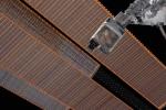
|
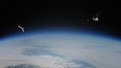
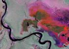
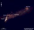
-
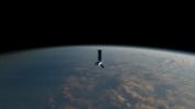
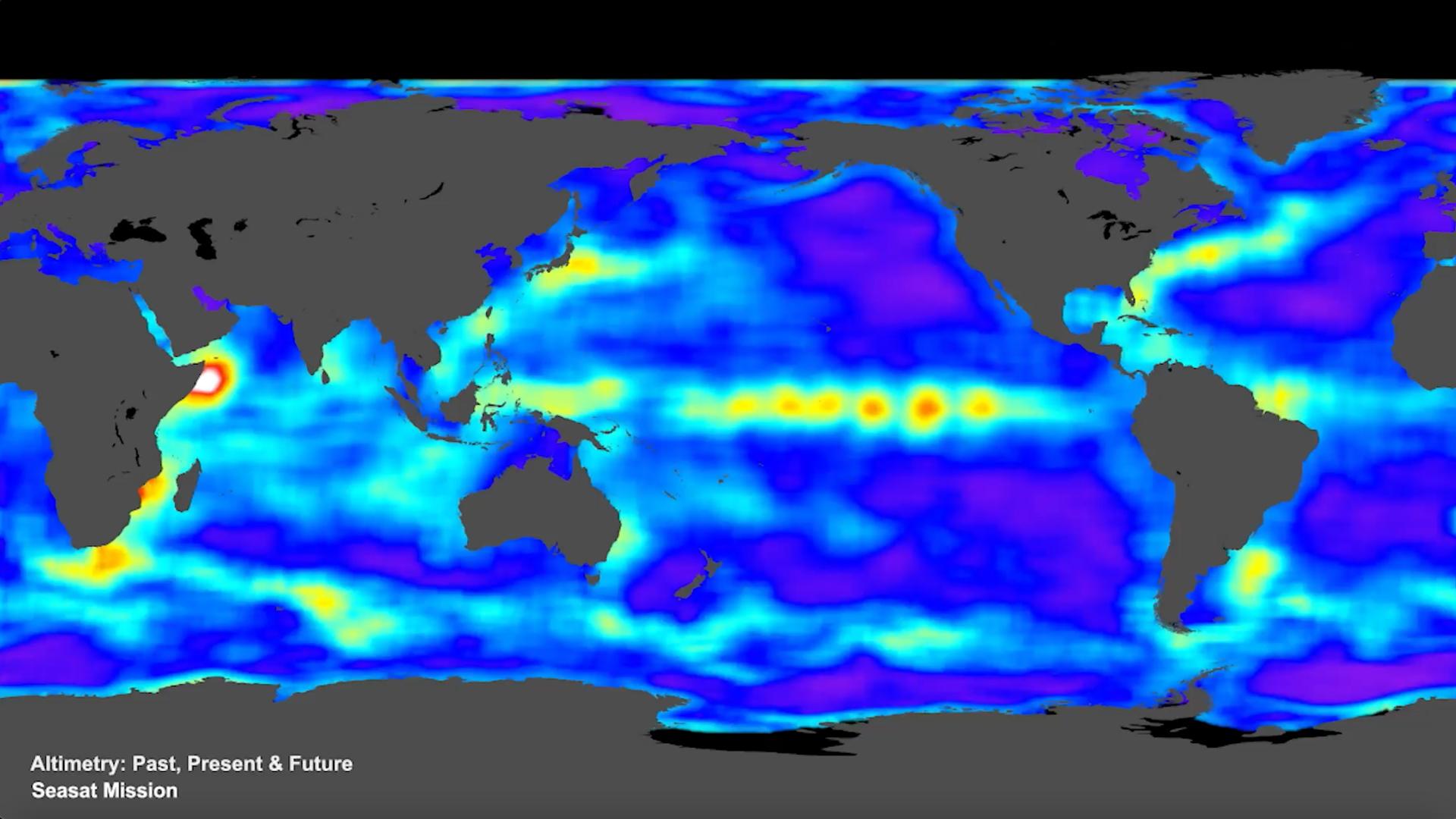
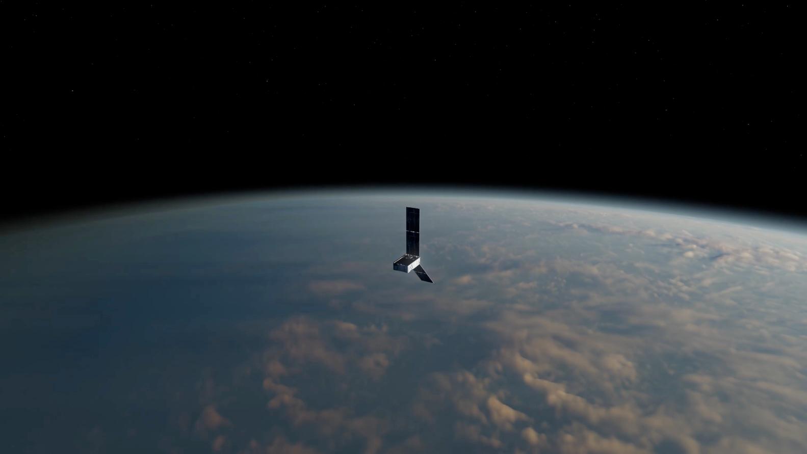
PIA22653:
-
Mini Mission RainCube is Sent into Earth Orbit
Full Resolution:
TIFF
(330.8 kB)
JPEG
(210.5 kB)
|
|
|
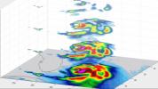
2018-09-25 |
Earth
|
CubeSat
|
|
1280x434x3 |

|
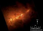
-
PIA22654:
-
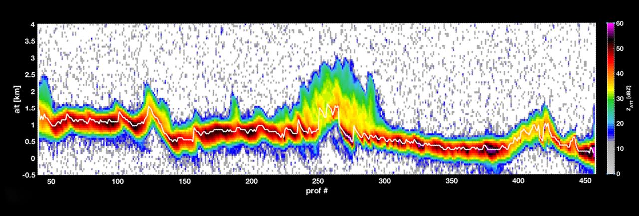
RainCube Collects First Storm Data
Full Resolution:
TIFF
(759.9 kB)
JPEG
(106.9 kB)
|
|
|
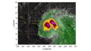
2018-10-09 |
Earth
|
SMAP
|
|
792x612x3 |
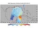
|
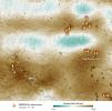
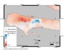
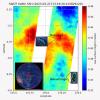
-
PIA22747:
-
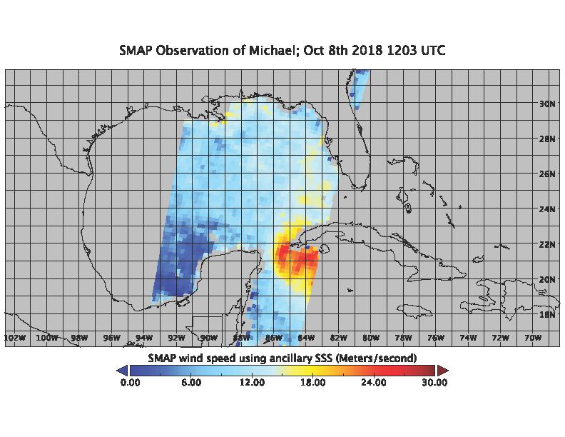
SMAP Captures Hurricane Michael
Full Resolution:
TIFF
(209 kB)
JPEG
(89.97 kB)
|
|
|
2018-10-10 |
Earth
|
SMAP
|
|
792x612x3 |

|
-
PIA22751:
-
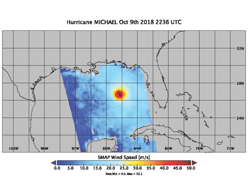
Hurricane Michael as seen by SMAP
Full Resolution:
TIFF
(202.1 kB)
JPEG
(62.84 kB)
|
|
|
2018-10-11 |
Earth
|
SMAP
|
|
2991x1065x3 |
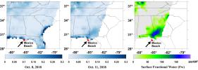
|
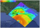
-
PIA22754:
-
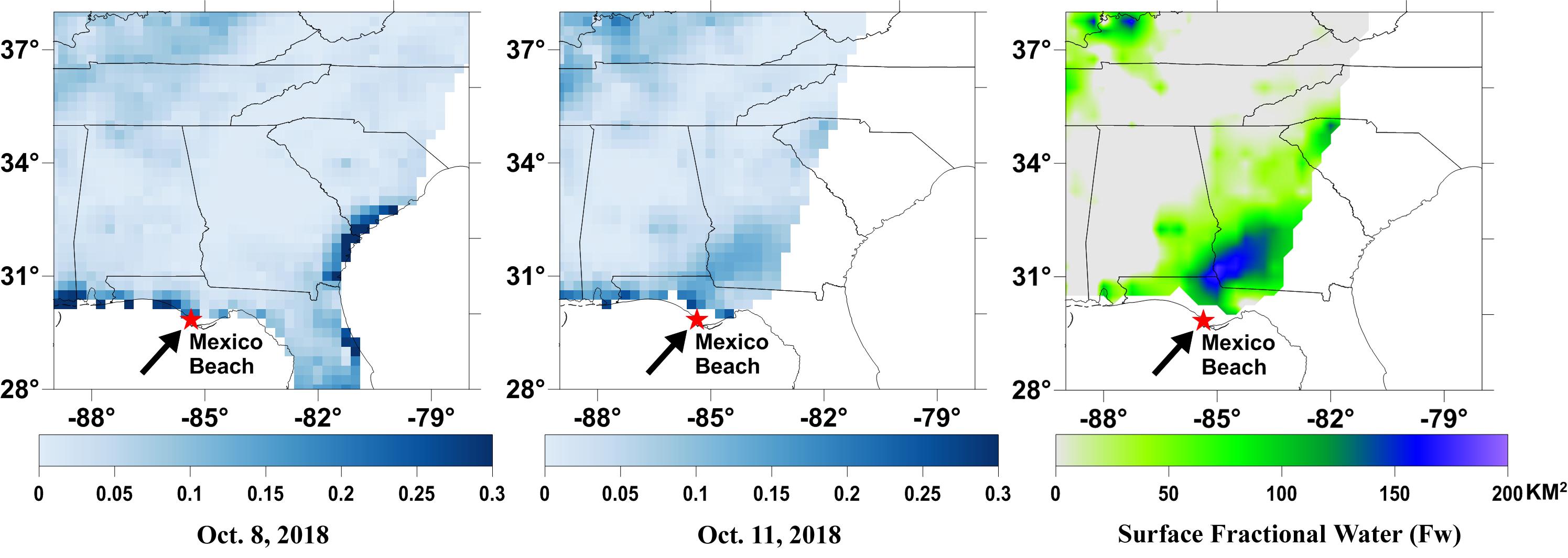
NASA's SMAP Detects Flooding from Hurricane Michael
Full Resolution:
TIFF
(1.747 MB)
JPEG
(255.8 kB)
|
|
|
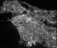
2019-05-16 |
Earth
|
CubeSat
|
|
2592x2192x1 |
|
-
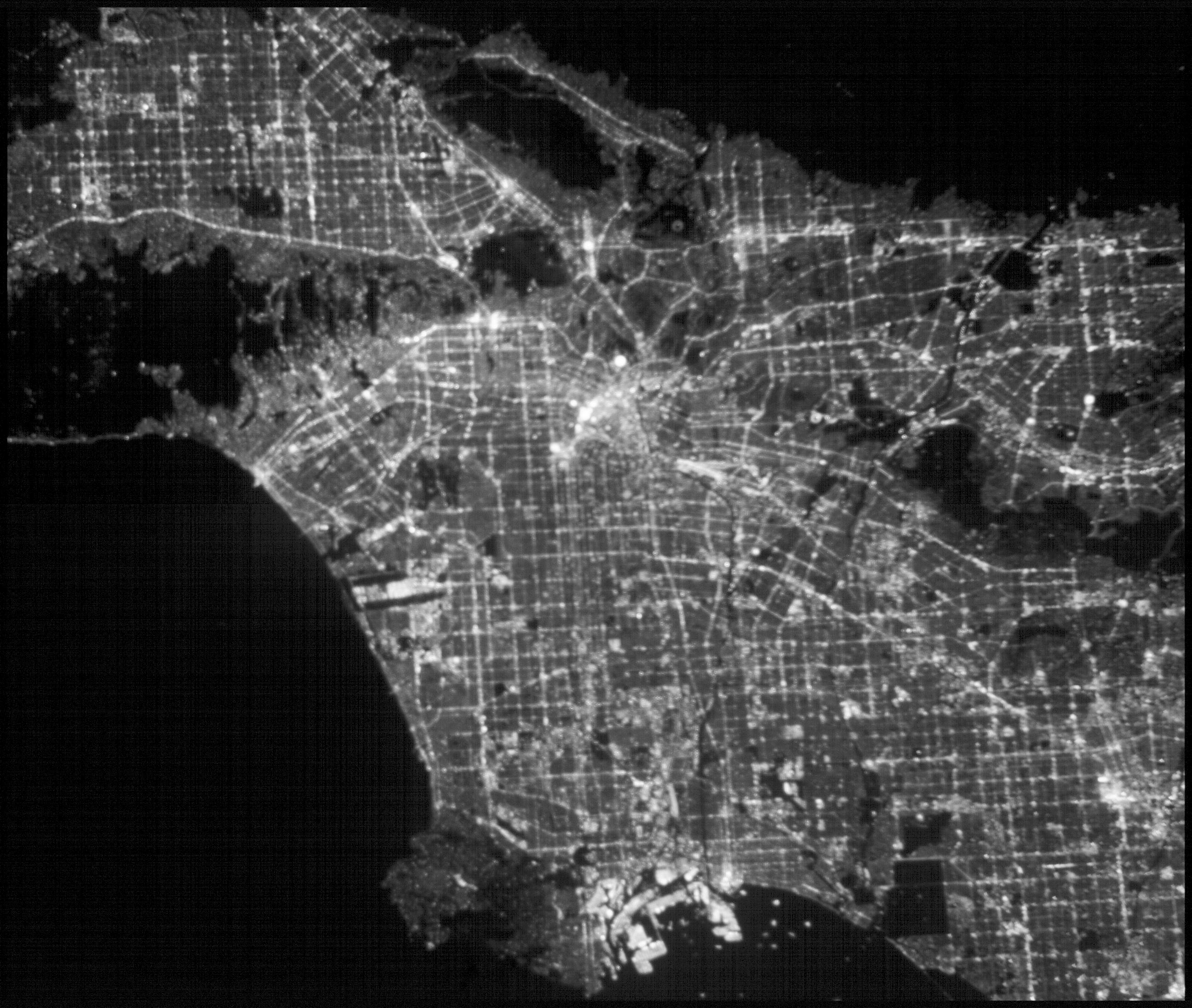
PIA23124:
-
ASTERIA Image of Los Angeles 1
Full Resolution:
TIFF
(4.729 MB)
JPEG
(440.4 kB)
|
|
|
2019-05-16 |
Earth
|
CubeSat
|
|
2592x2192x1 |
|
-
PIA23125:
-
ASTERIA Image of Los Angeles 2
Full Resolution:
TIFF
(4.963 MB)
JPEG
(831.4 kB)
|
|
|
2019-05-17 |
Earth
|
SMAP
|
|
1400x787x3 |
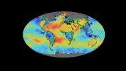
|
-
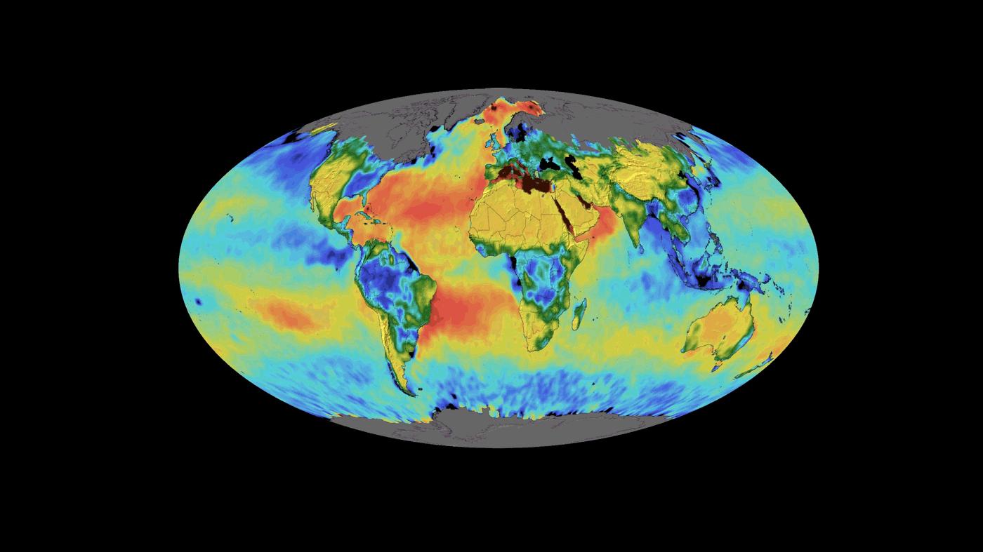
PIA23146:
-
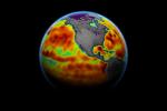
SMAP Sea Surface Salinity and Soil Moisture Time Lapse
Full Resolution:
TIFF
(1.025 MB)
JPEG
(82.57 kB)
|
|
|
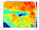
2019-07-02 |
Earth
|
ECOSTRESS
|
|
2258x2190x3 |
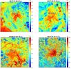
|
-
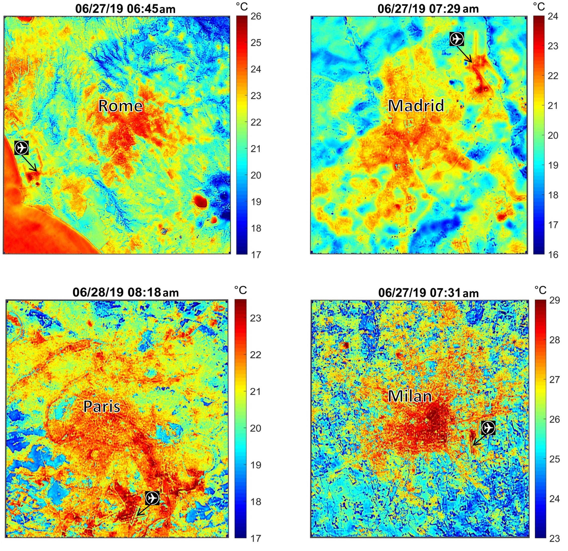
PIA23148:
-
NASA's ECOSTRESS Maps Europe Heat Wave
Full Resolution:
TIFF
(13.41 MB)
JPEG
(928.6 kB)
|
|
|
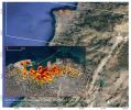
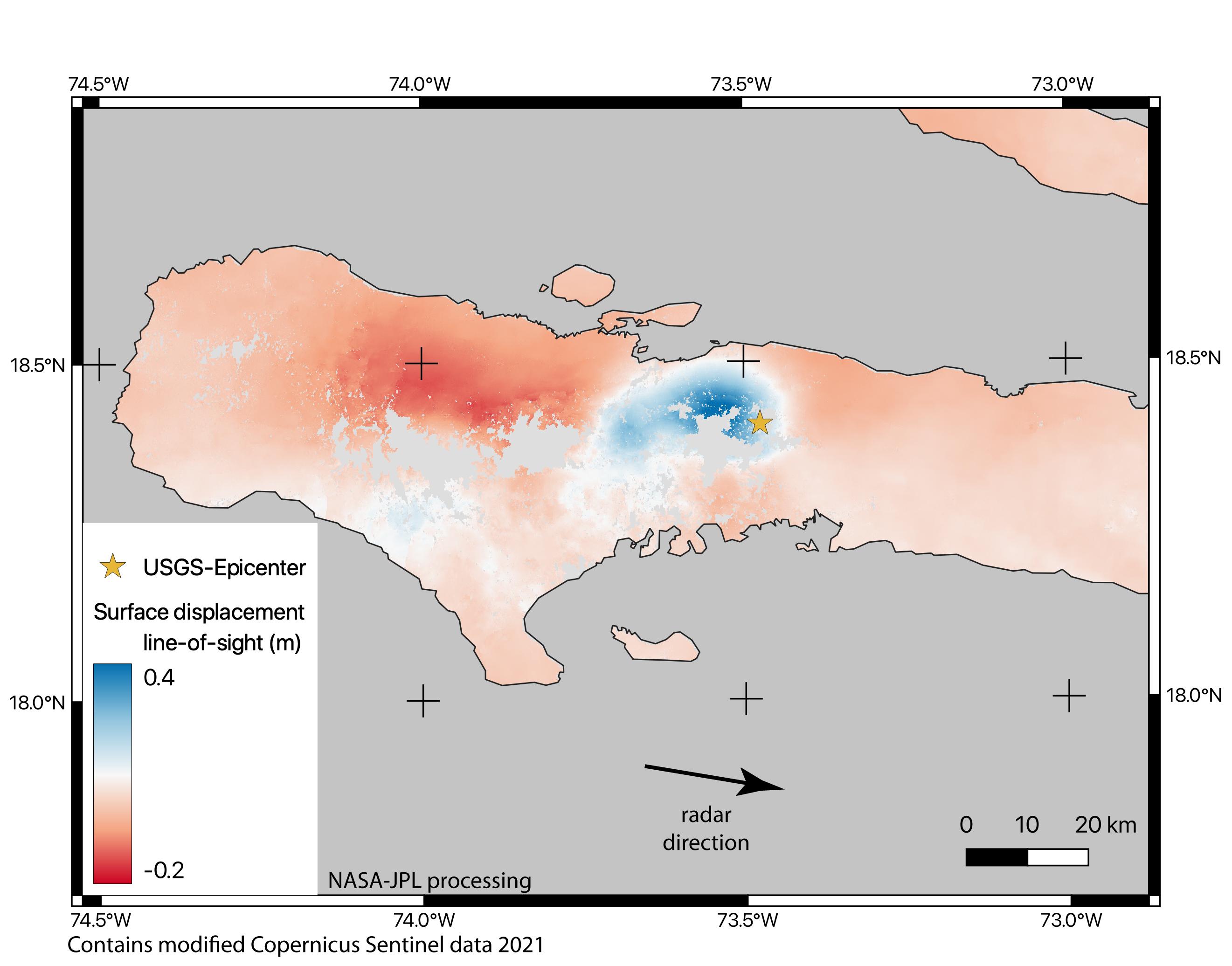
2019-07-11 |
Earth
|
ARIA
|
|
1754x1959x3 |
|
-
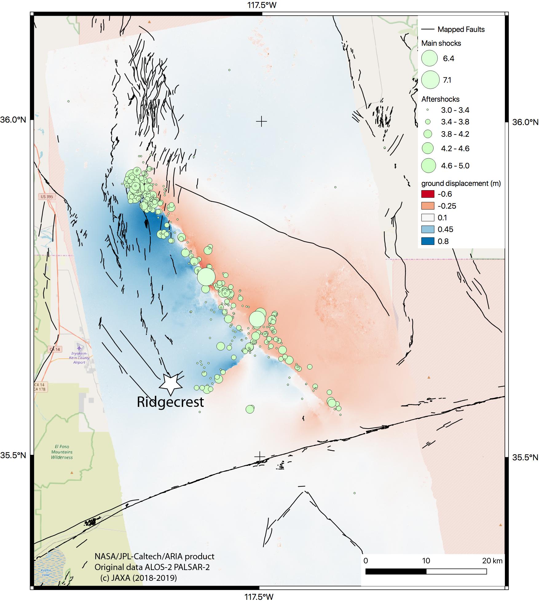
PIA23351:
-
NASA Map Shows Ground Movement from California Quakes
Full Resolution:
TIFF
(4.263 MB)
JPEG
(292.6 kB)
|
|
|
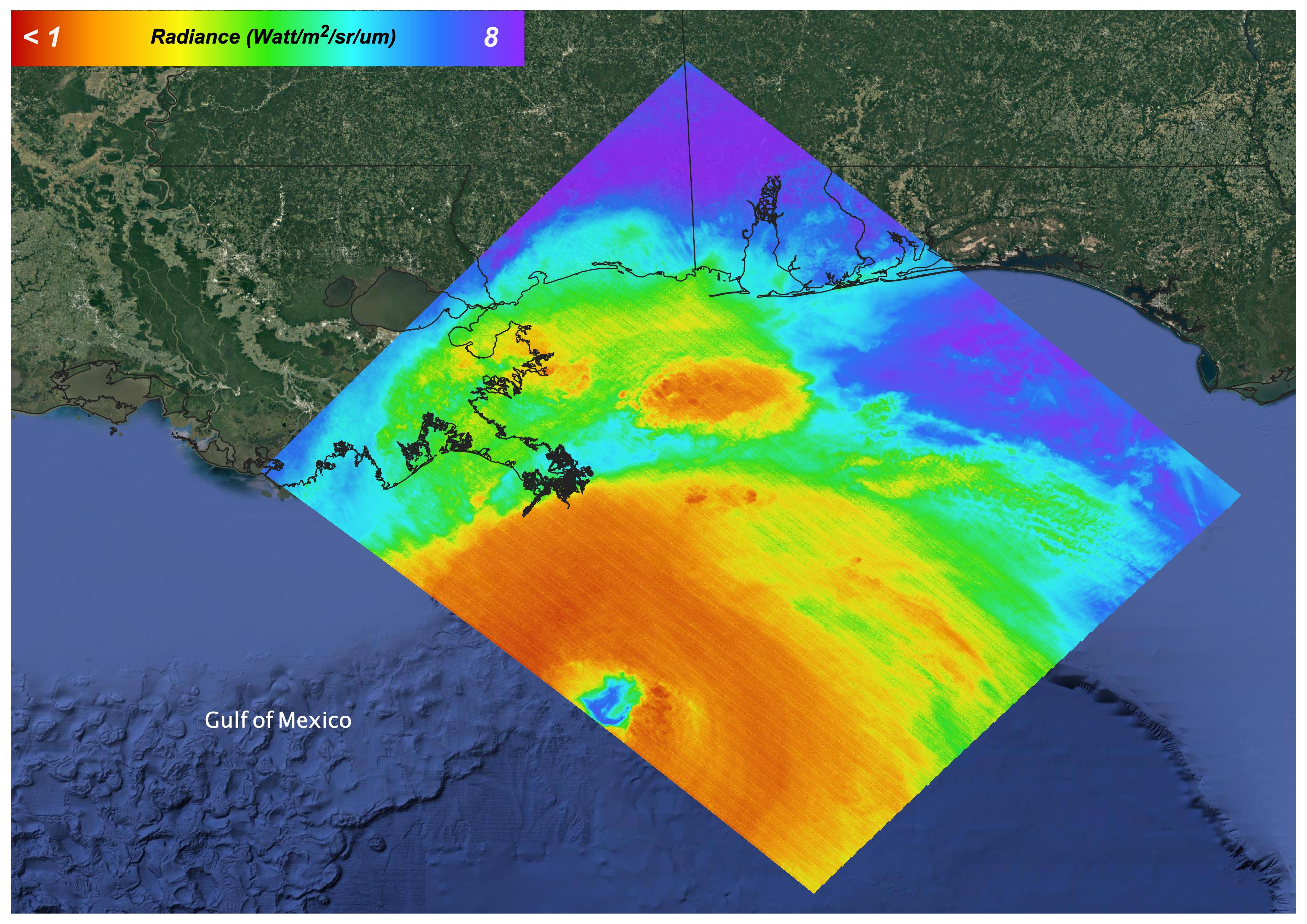
2019-08-08 |
Earth
|
ECOSTRESS
|
|
974x864x3 |
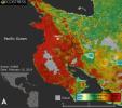
|
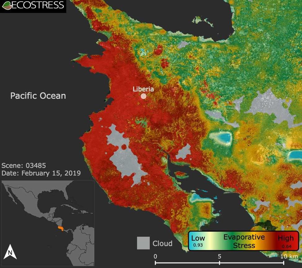
-
PIA22839:
-
ECOSTRESS Focuses on Costa Rican Drought
Full Resolution:
TIFF
(1.922 MB)
JPEG
(129.8 kB)
|
|
|
2019-08-29 |
Earth
|
CubeSat
|
|
1400x778x3 |
|
-
PIA23414:
-
Small Satellite TEMPEST-D Sees Hurricane Dorian off Coast
Full Resolution:
TIFF
(1.738 MB)
JPEG
(121.2 kB)
|
|
|
2019-09-04 |
Earth
|
CubeSat
|
|
1400x788x3 |
|
-
PIA23431:
-
TEMPEST-D CubeSat Sees Hurricane Dorian in 3D
Full Resolution:
TIFF
(1.581 MB)
JPEG
(105.9 kB)
|
|
|
2019-08-28 |
Earth
|
ECOSTRESS
|
|
1867x1132x3 |
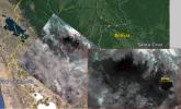
|
-
PIA23357:
-
Amazon Fires Seen by NASA's ECOSTRESS
Full Resolution:
TIFF
(6.142 MB)
JPEG
(260.2 kB)
|
|
|
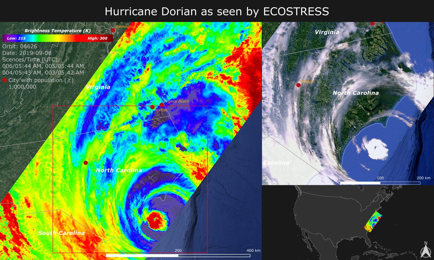
2019-09-18 |
Earth
|
ECOSTRESS
|
|
1430x857x3 |

|
-
PIA23422:
-
NASA Images Hurricane Dorian's Temperature from Space
Full Resolution:
TIFF
(3.196 MB)
JPEG
(252.8 kB)
|
|
|
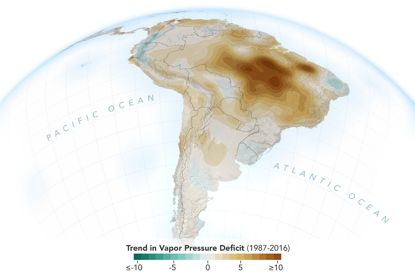
2019-11-05 |
Earth
|
|
|
1440x960x3 |

|
-
PIA23425:
-
New Study Shows Atmosphere in the Amazon Drying Out
Full Resolution:
TIFF
(1.789 MB)
JPEG
(96.3 kB)
|
|
|
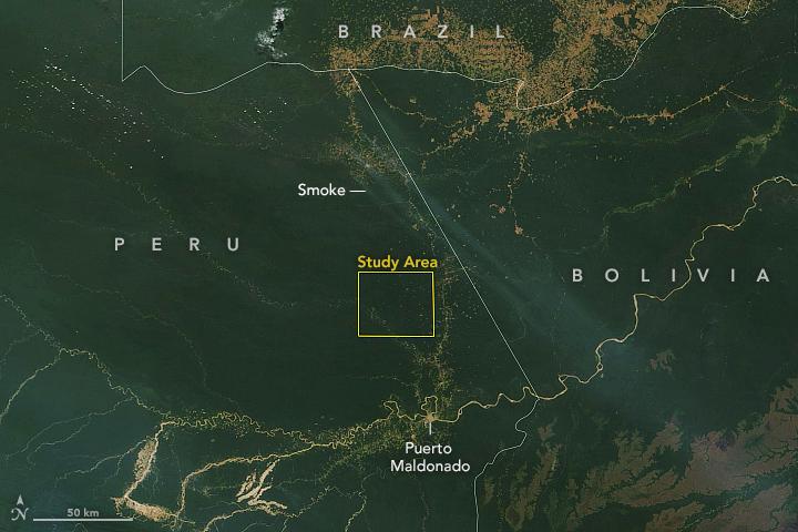
2019-11-05 |
Earth
|
ECOSTRESS
|
|
720x715x3 |
|
-
PIA23432:
-
Drought-Stressed Forest Fueled Amazon Fires
Full Resolution:
TIFF
(1.545 MB)
JPEG
(112.1 kB)
|
|
|
2019-11-05 |
Earth
|
Terra
|
|
720x480x3 |
|
-
PIA23546:
-
NASA Terra Satellite Sees Amazon Fires in Peru
Full Resolution:
TIFF
(855.7 kB)
JPEG
(51.57 kB)
|
|
|
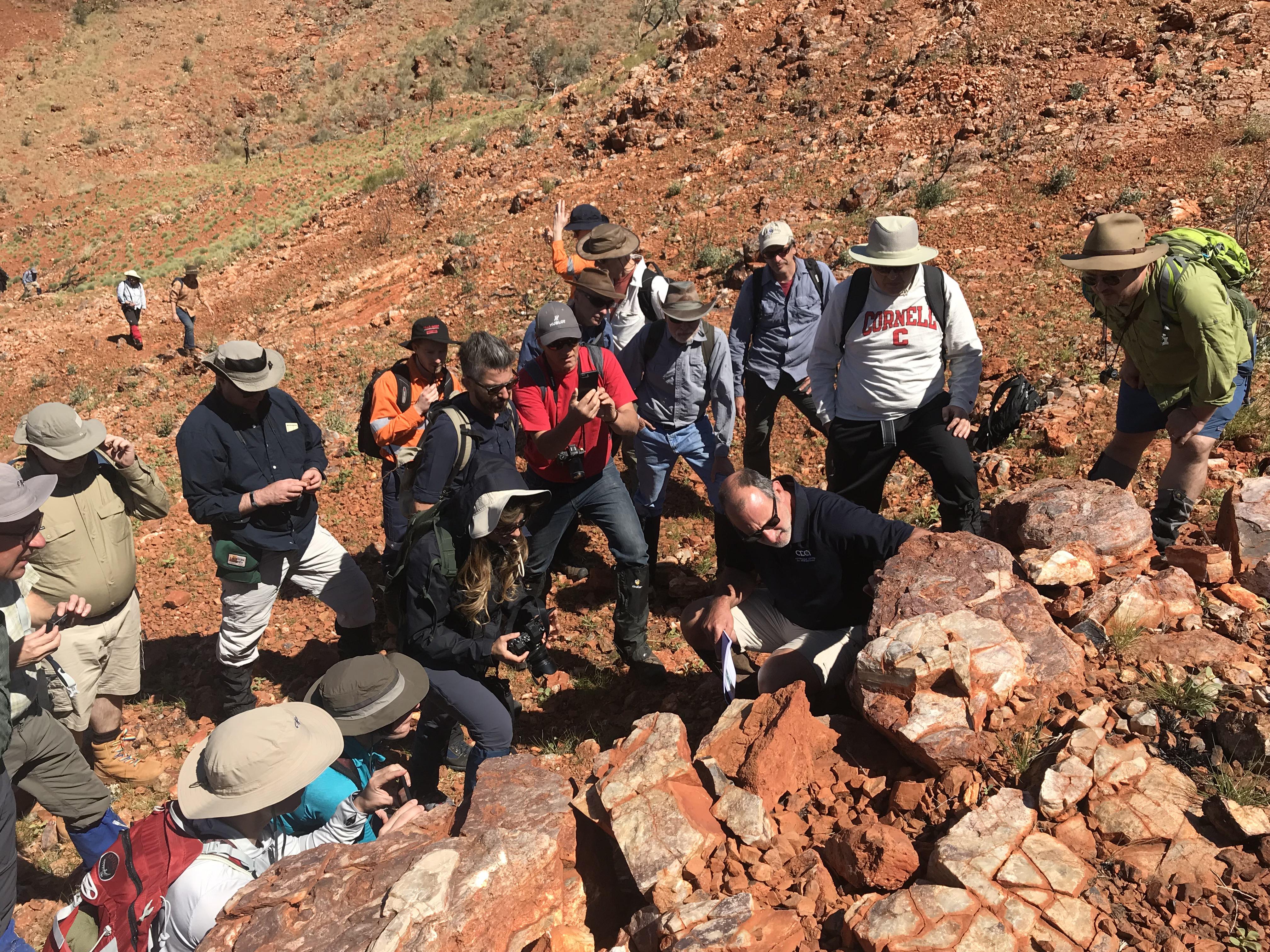
2019-11-15 |
Earth
|
Mars 2020 Rover
|
|
4032x3024x3 |

|
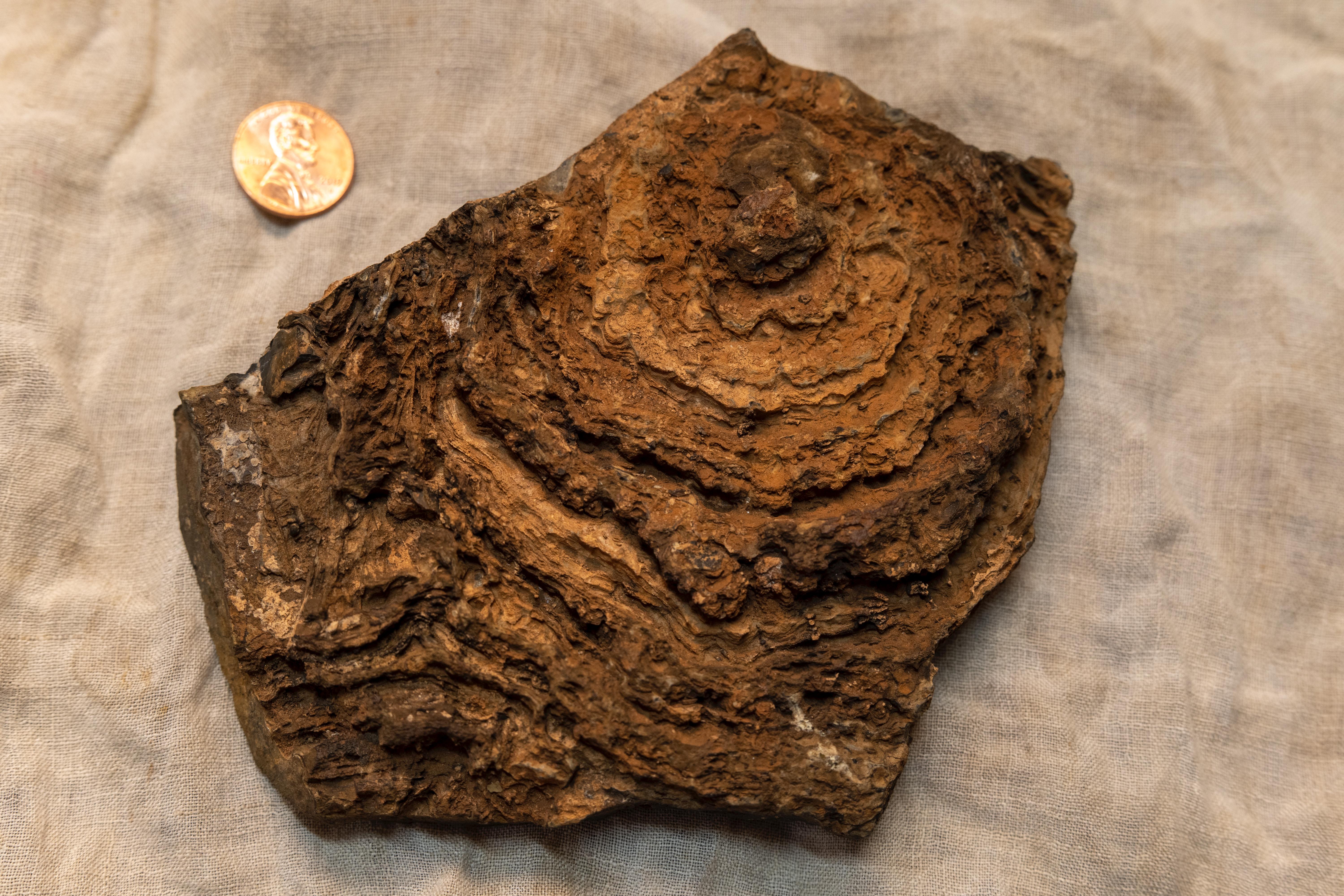
-
PIA23551:
-
Researching Outback Stromatolites
Full Resolution:
TIFF
(36.59 MB)
JPEG
(2.427 MB)
|
|
|
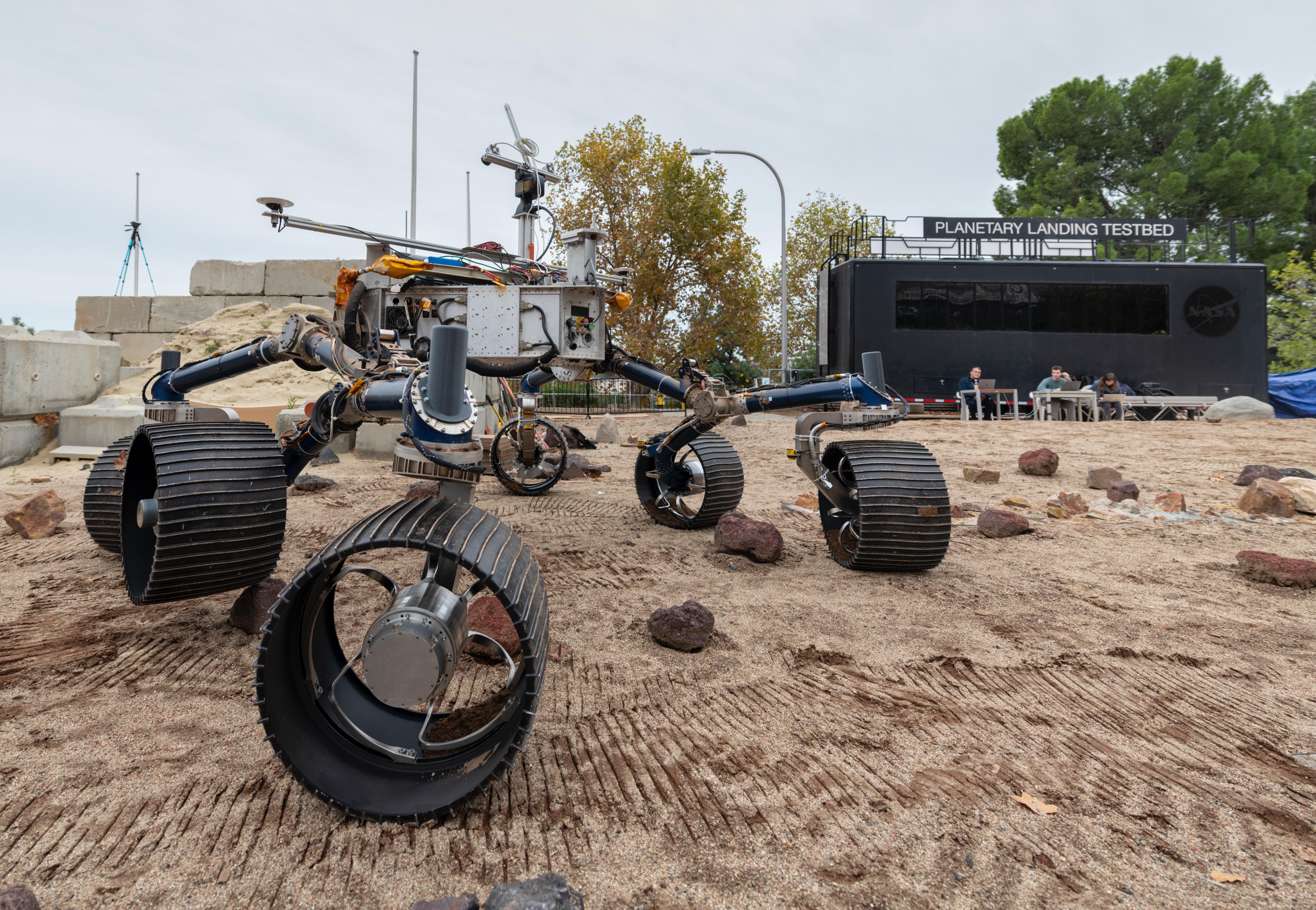
2019-12-16 |
Earth
|
Mars 2020 Rover
|
|
6417x4437x3 |
|
-
PIA23498:
-
Mars 2020 Makes Tracks for the Red Planet in the Mars Yard
Full Resolution:
TIFF
(73.43 MB)
JPEG
(3.678 MB)
|
|
|
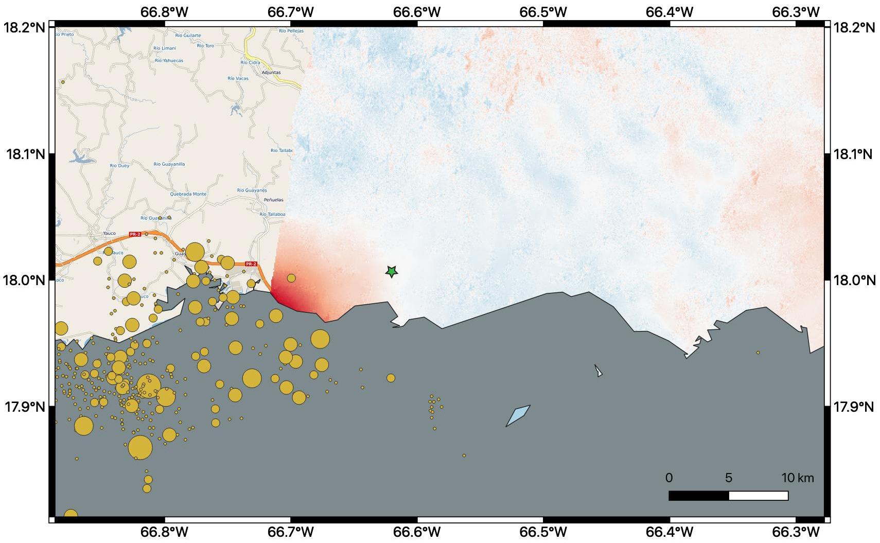
2020-01-10 |
Earth
|
ARIA
|
|
1710x1055x3 |
|
-
PIA23428:
-
Puerto Rico Quake Damage Visible From Space
Full Resolution:
TIFF
(2.476 MB)
JPEG
(189 kB)
|
|
|
2020-02-04 |
Earth
|
ECOSTRESS
|
|
772x440x3 |

|
-
PIA23430:
-
The ECOSTRESS Mission Spots Plants as They Wake Up
Full Resolution:
TIFF
(1.02 MB)
JPEG
(72.92 kB)
|
|
|
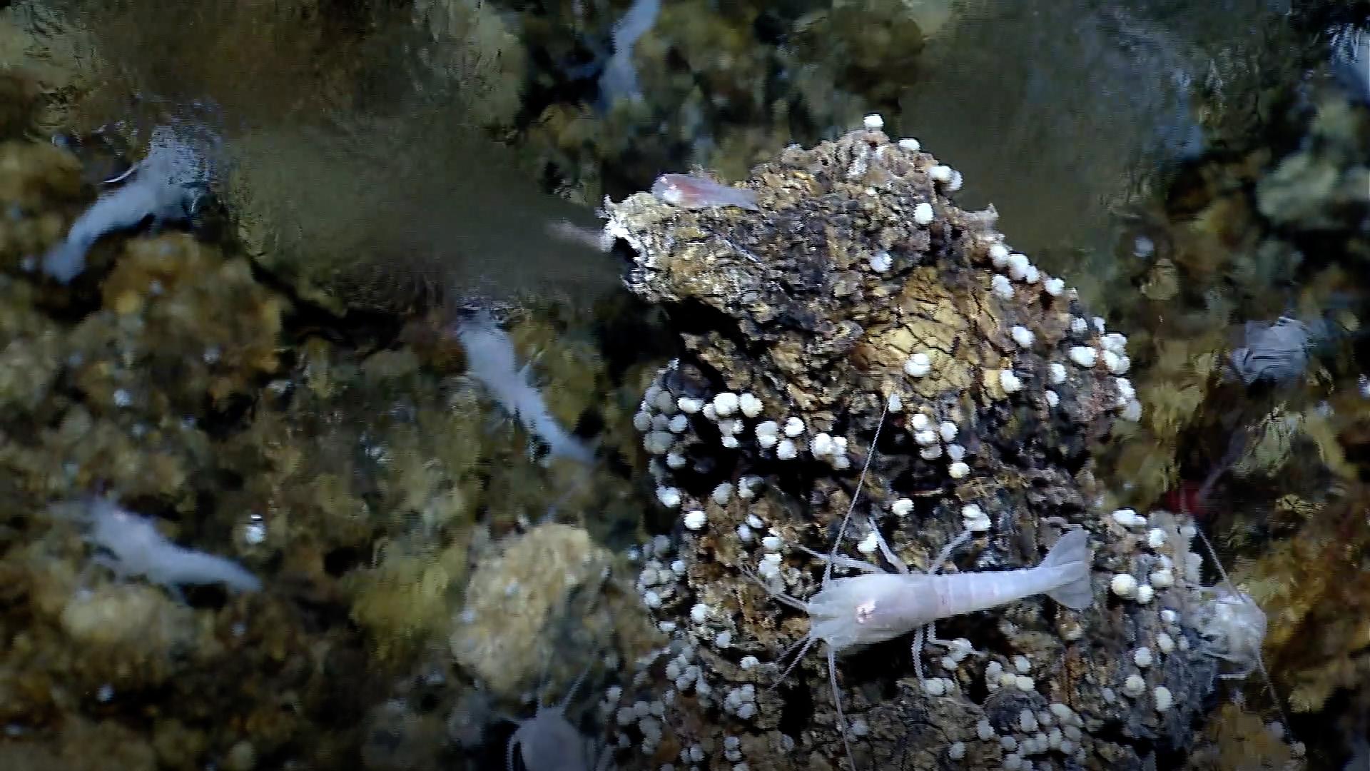
2020-04-15 |
Earth
|
|
|
1920x1080x3 |
|
-
PIA23686:
-
White Smoker Ocean Vents
Full Resolution:
TIFF
(6.172 MB)
JPEG
(270.2 kB)
|
|
|
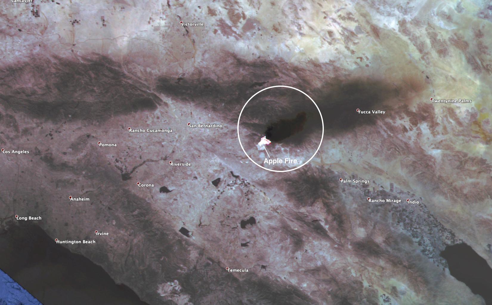
2020-08-03 |
Earth
|
ECOSTRESS
|
|
2908x2224x3 |
|
-
PIA23798:
-
ECOSTRESS Gauges the Apple Fire's Temperature From Space
Full Resolution:
TIFF
(14.41 MB)
JPEG
(620.1 kB)
|
|
|
2020-08-03 |
Earth
|
ECOSTRESS
|
|
1650x1023x3 |

|
-
PIA23799:
-
ECOSTRESS Spies Apple Fire's Smoke Plume
Full Resolution:
TIFF
(4.924 MB)
JPEG
(188.5 kB)
|
|
|
2020-08-07 |
Earth
|
ARIA
|
|
2944x2480x3 |
|
-
PIA23692:
-
ARIA Damage Map: Beirut Explosion Aftermath
Full Resolution:
TIFF
(19.6 MB)
JPEG
(1.471 MB)
|
|
|
2020-08-19 |
Earth
|
ECOSTRESS
|
|
3507x2480x3 |
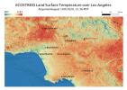
|
-
PIA23786:
-
Los Angeles Heat Wave
Full Resolution:
TIFF
(19.81 MB)
JPEG
(1.073 MB)
|
|
|
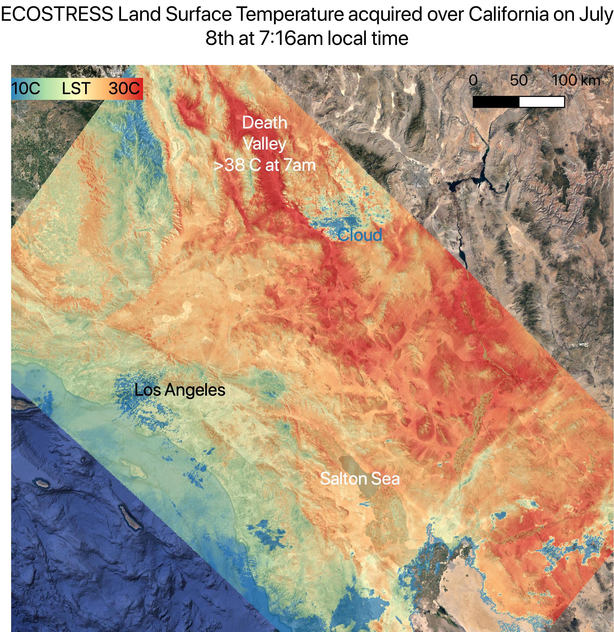
2020-08-19 |
Earth
|
ECOSTRESS
|
|
3447x2404x3 |
|
-
PIA23787:
-
Death Valley Heats Up
Full Resolution:
TIFF
(23.97 MB)
JPEG
(1.434 MB)
|
|
|
2020-08-27 |
Earth
|
ECOSTRESS
|
|
3507x2480x3 |
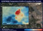
|
-
PIA23215:
-
NASA's ECOSTRESS Sees Fire-Induced Tornado From Space
Full Resolution:
TIFF
(21.72 MB)
JPEG
(1.14 MB)
|
|
|
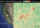
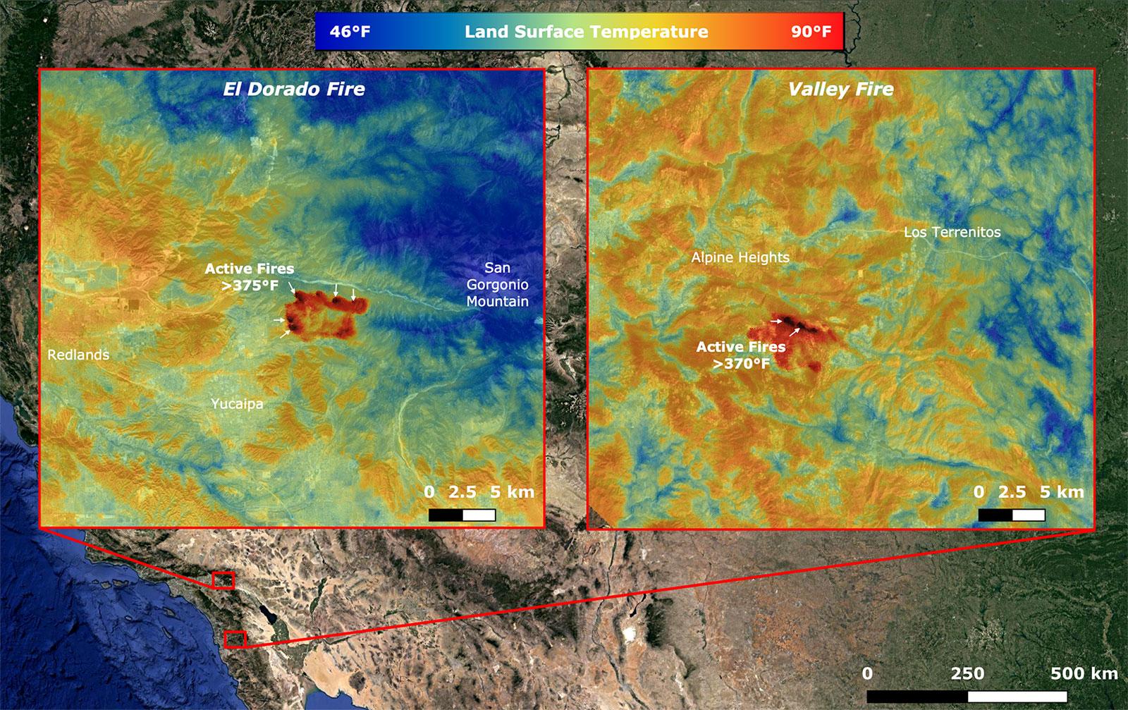
2020-09-08 |
Earth
|
ECOSTRESS
|
|
1600x1007x3 |
|
-
PIA23788:
-
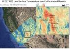
NASA's ECOSTRESS Takes Surface Temperature Around California Fires
Full Resolution:
TIFF
(4.835 MB)
JPEG
(361.7 kB)
|
|
|
2020-09-23 |
Earth
|
|
|
8000x5955x3 |
|
-
PIA23790:
-
OASIS Study Project (Illustration)
Full Resolution:
TIFF
(104.1 MB)
JPEG
(4.095 MB)
|
|
|
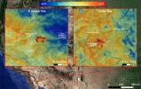
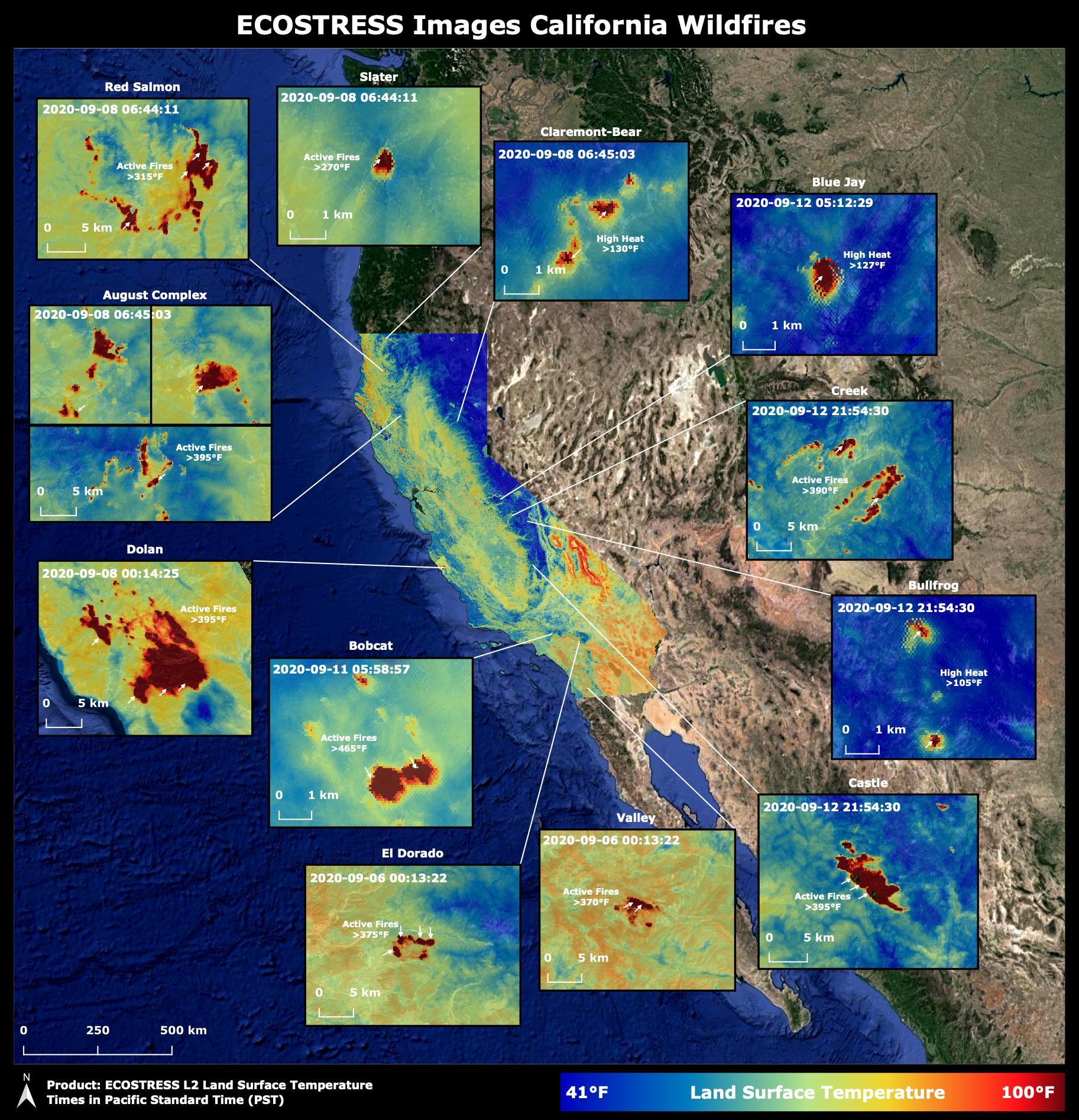
2020-10-02 |
Earth
|
ECOSTRESS
|
|
1825x1894x3 |

|
-
PIA23721:
-
NASA's ECOSTRESS Images California Wildfires From Space
Full Resolution:
TIFF
(10.37 MB)
JPEG
(633.2 kB)
|
|
|
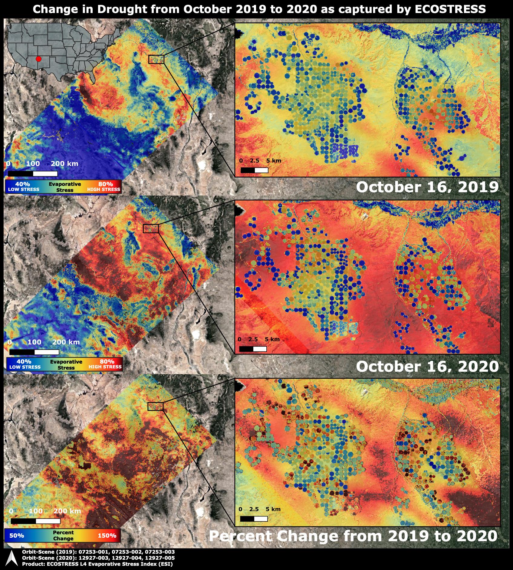
2020-10-28 |
Earth
|
ECOSTRESS
|
|
1695x1883x3 |

|
-
PIA24132:
-
ECOSTRESS Drought Stress Comparison
Full Resolution:
TIFF
(9.579 MB)
JPEG
(930 kB)
|
|
|
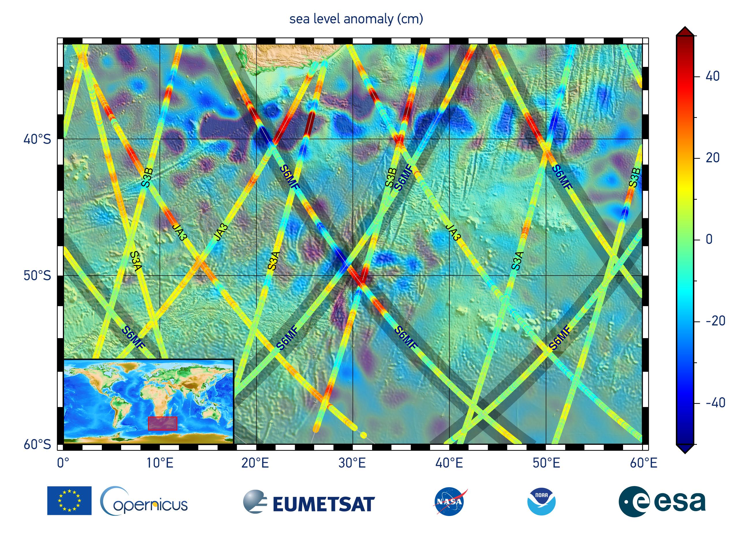
2020-12-10 |
Earth
|
Sentinel-6/Jason-CS
|
|
2600x1849x3 |
|
-
PIA24135:
-
Sentinel-6 Michael Freilich First Light Sea Level
Full Resolution:
TIFF
(10.71 MB)
JPEG
(704.9 kB)
|
|
|
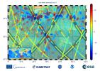
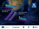
2020-12-10 |
Earth
|
Sentinel-6/Jason-CS
|
|
1216x900x3 |
|
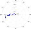
-
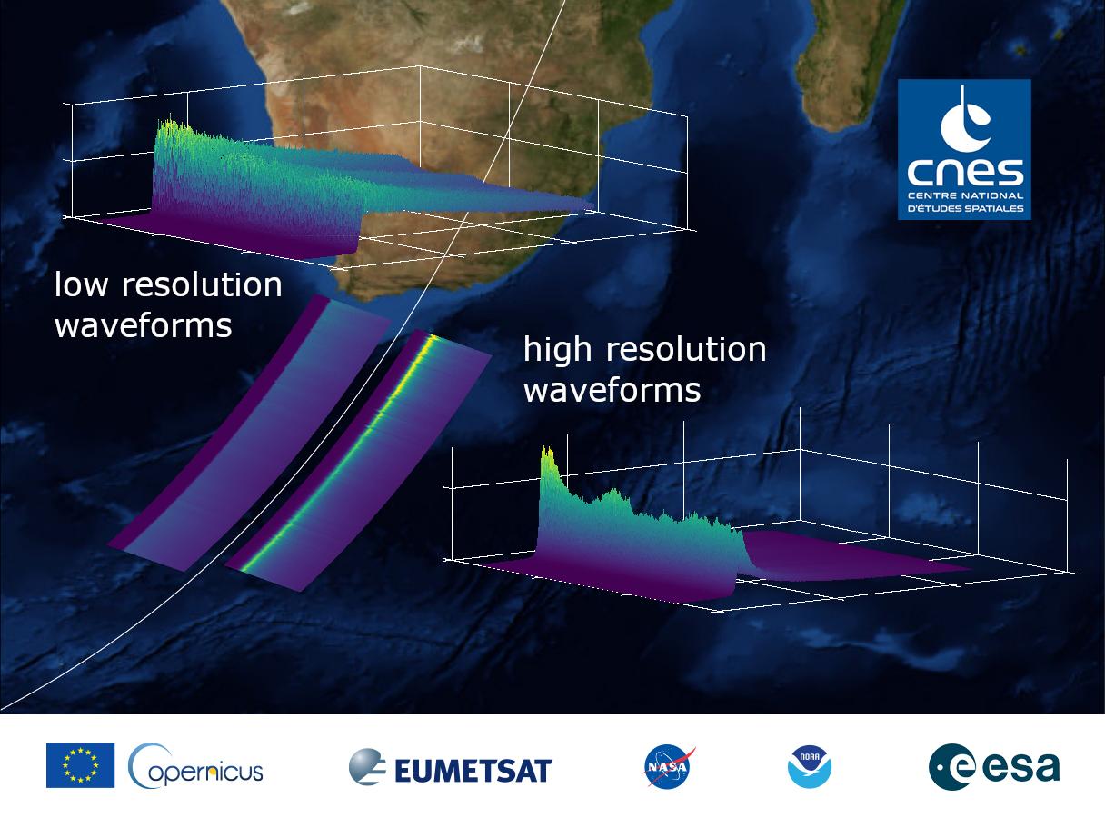
PIA24136:
-
Sentinel-6 Michael Freilich First Light Waveform
Full Resolution:
TIFF
(2.221 MB)
JPEG
(121.2 kB)
|
|
|
2021-01-25 |
Earth
|
OMG
|
|
3792x2846x3 |
|
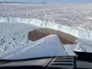
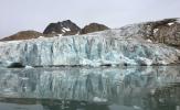
-
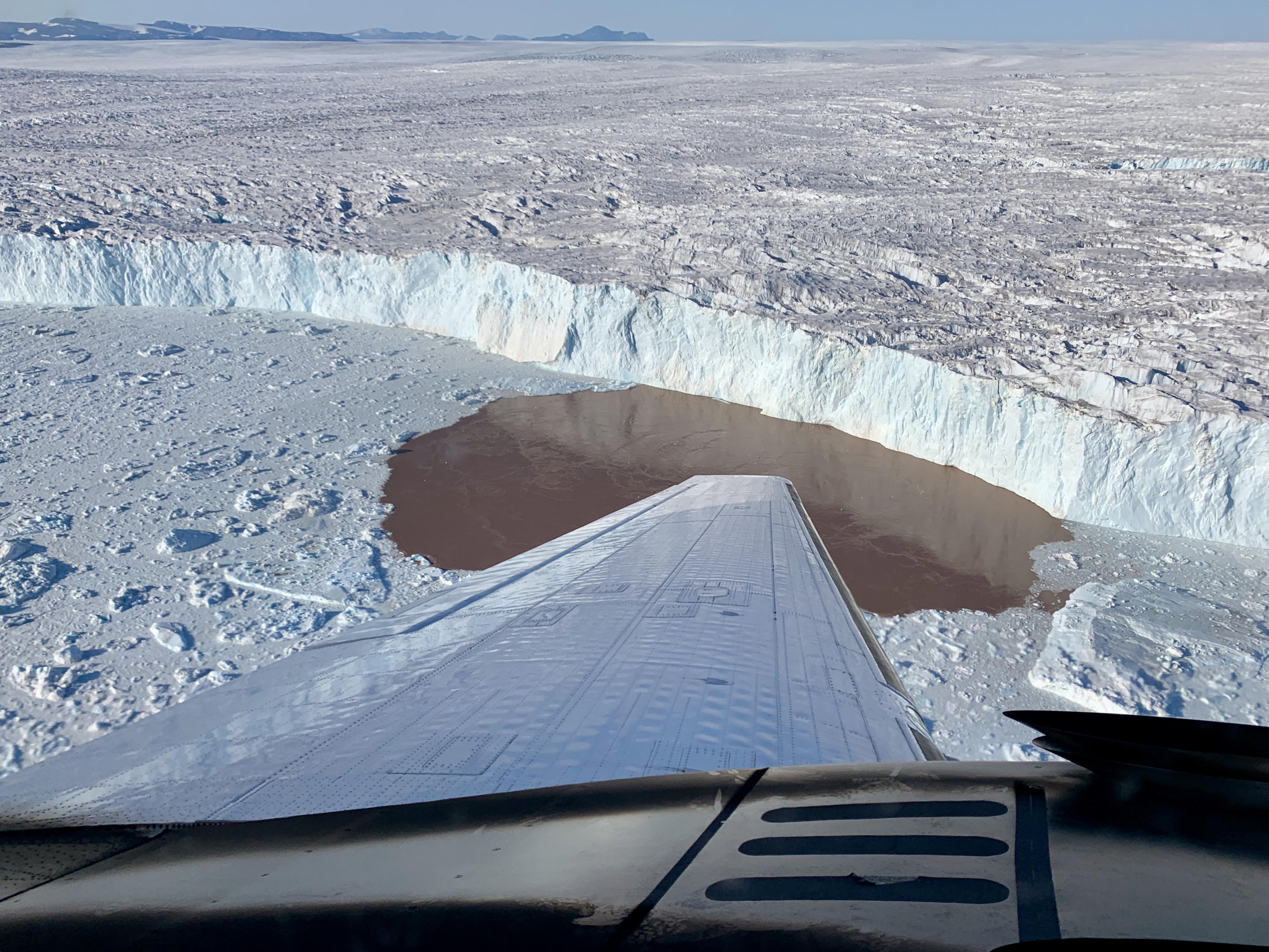
PIA24162:
-
Glacier Undercutting in Action
Full Resolution:
TIFF
(26.91 MB)
JPEG
(1.386 MB)
|
|
|
2021-01-27 |
Earth
|
|
|
1024x768x3 |

|
-
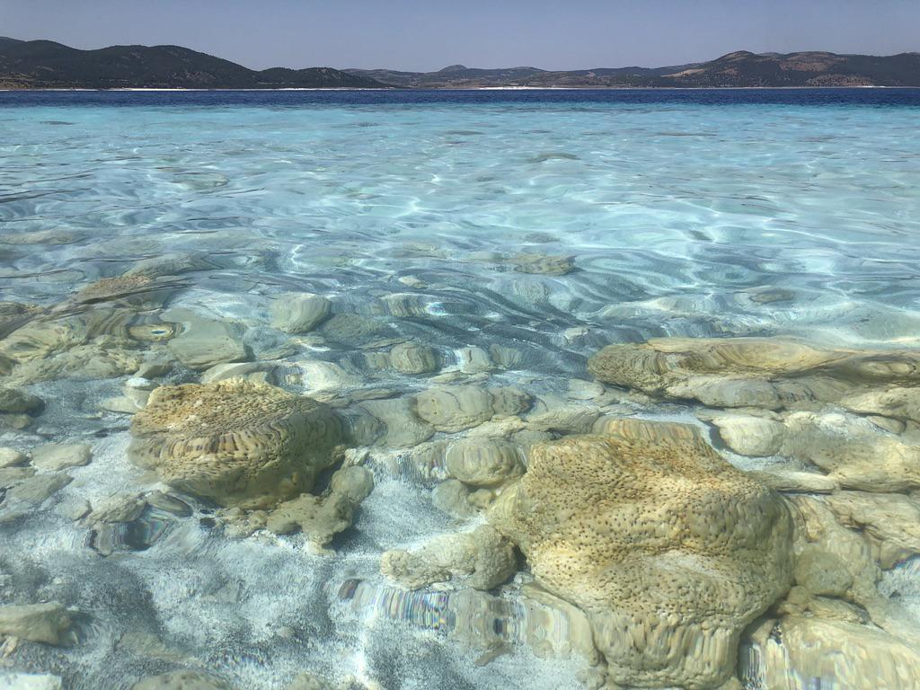
PIA24374:
-
Lake Salda Rocks
Full Resolution:
TIFF
(2.36 MB)
JPEG
(146.1 kB)
|
|
|
2021-01-27 |
Earth
|
|
|
1024x768x3 |

|
-
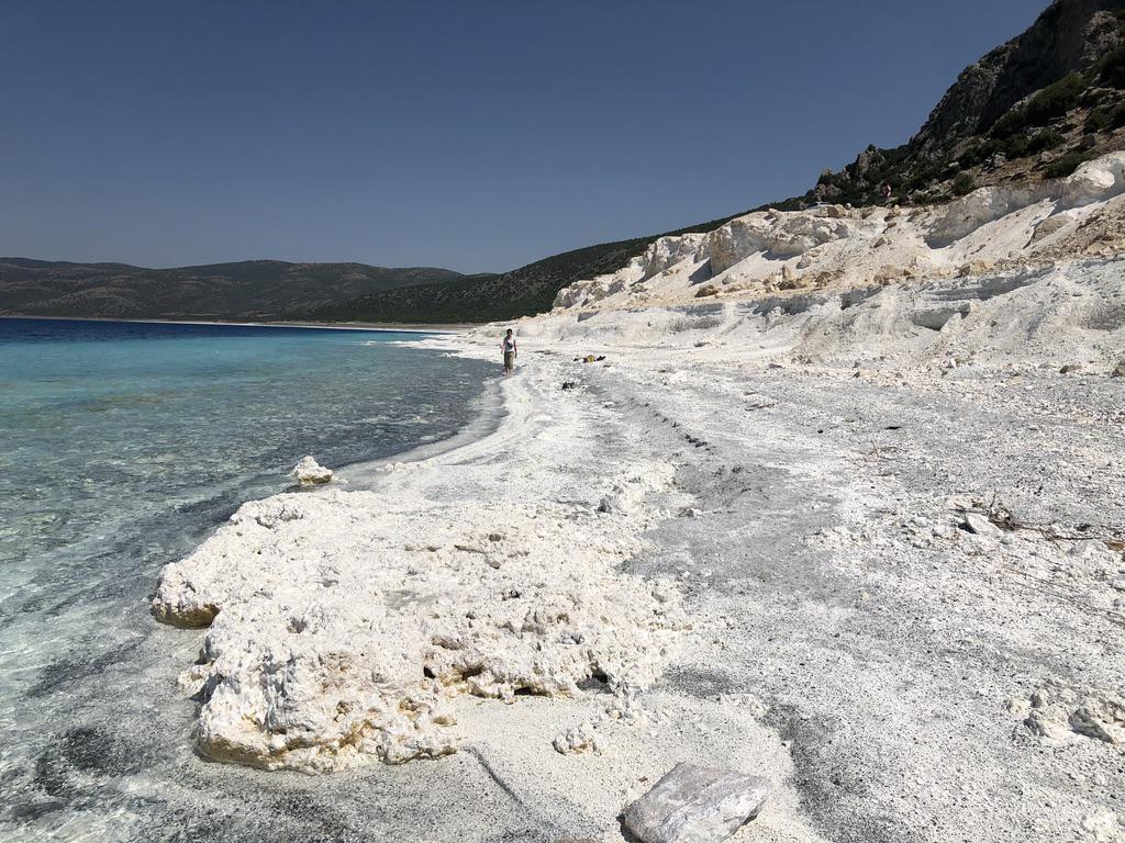
PIA24375:
-
Lake Salda Beach
Full Resolution:
TIFF
(2.112 MB)
JPEG
(189.6 kB)
|
|
|
2021-02-17 |
Earth
|
Mars 2020 Project
|
|
6000x4000x3 |
|
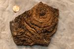
-
PIA24240:
-
Tumbiana Stromatolite
Full Resolution:
TIFF
(66.96 MB)
JPEG
(3.093 MB)
|
|
|
2021-06-21 |
Earth
|
Sentinel-6/Jason-CS
|
|
1536x1024x3 |
|
-
PIA24533:
-
Sentinel-6 Michael Freilich Sea Surface Height
Full Resolution:
TIFF
(1.492 MB)
JPEG
(78.4 kB)
|
|
|
2021-07-15 |
Earth
|
ECOSTRESS
|
|
1984x2041x3 |
|
-
PIA23694:
-
July 2021 Heat Wave Ground Temperature
Full Resolution:
TIFF
(12.15 MB)
JPEG
(746.2 kB)
|
|
|
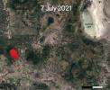
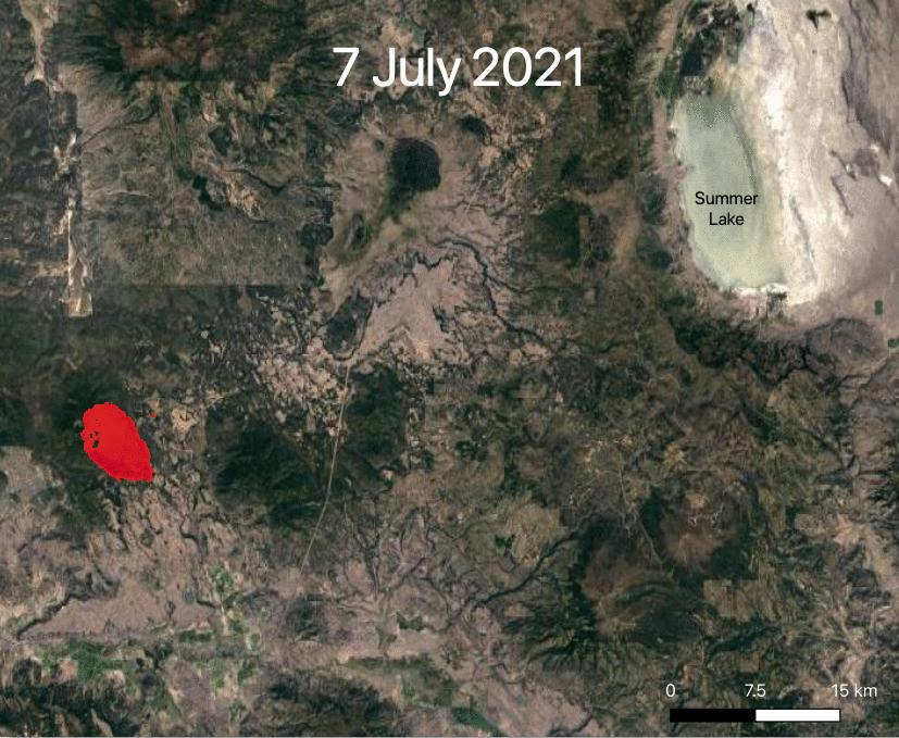
2021-07-29 |
Earth
|
ECOSTRESS
|
|
827x679x3 |
|
-
PIA23695:
-
ECOSTRESS Views 2021 Southern Oregon Bootleg Fire
Full Resolution:
TIFF
(1.685 MB)
JPEG
(109.8 kB)
|
|
|
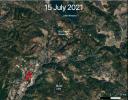
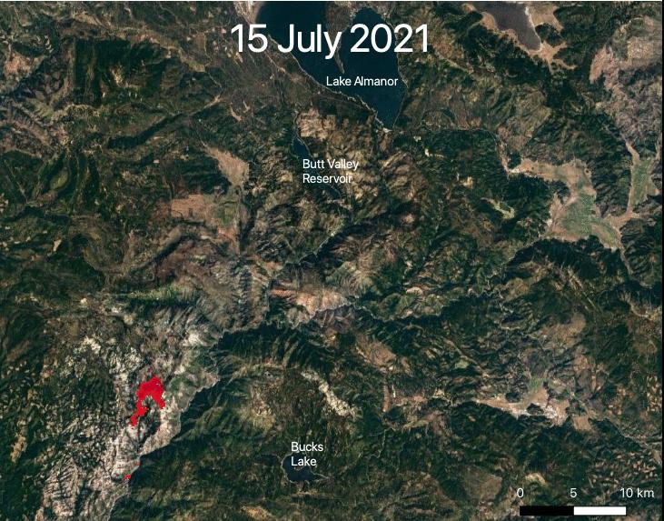
2021-07-29 |
Earth
|
ECOSTRESS
|
|
731x573x3 |
|
-
PIA23696:
-
ECOSTRESS Views 2021 Northern California Dixie Fire
Full Resolution:
TIFF
(1.257 MB)
JPEG
(113.3 kB)
|
|
|
2021-08-17 |
Earth
|
ARIA
|
|
2642x2072x3 |
|
-
PIA23697:
-
Satellite Data Shows Ground Motion from August 2021 Haiti Earthquake
Full Resolution:
TIFF
(2.886 MB)
JPEG
(298.8 kB)
|
|
|
2021-10-07 |
Earth
|
ECOSTRESS
|
|
3507x2480x3 |
|
-
PIA24209:
-
Glass Fire, September 27, 2020
Full Resolution:
TIFF
(14.05 MB)
JPEG
(854.1 kB)
|
|
|
2021-10-07 |
Earth
|
ECOSTRESS
|
|
3507x2480x3 |
|
-
PIA24210:
-
Hurricane Ida, August 27, 2021
Full Resolution:
TIFF
(21.59 MB)
JPEG
(1.144 MB)
|
|
|
2021-10-27 |
Earth
|
ECOSTRESS
|
|
3507x2480x3 |
|
-
PIA24916:
-
La Palma Volcano
Full Resolution:
TIFF
(16.12 MB)
JPEG
(719.5 kB)
|
|
|
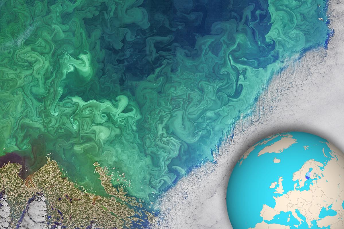
2021-12-17 |
Earth
|
Landsat
|
|
1200x800x3 |

|
-
PIA25033:
-
Phytoplankton Bloom in the South of Bothnia
Full Resolution:
TIFF
(2.881 MB)
JPEG
(176.5 kB)
|
|
|
2022-01-26 |
Earth
|
OMG
|
|
4032x2471x3 |
|
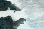
-
PIA24983:
-
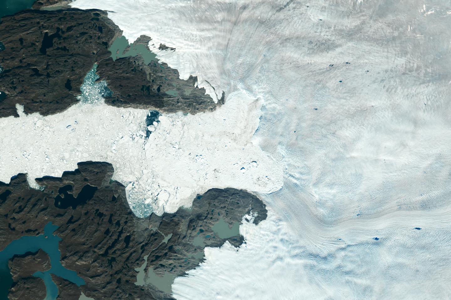
Apusiaajik Glacier, Greenland
Full Resolution:
TIFF
(24.23 MB)
JPEG
(1.213 MB)
|
|
|
2022-01-26 |
Earth
|
OMG
|
|
3024x2697x3 |

|
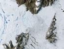
-
PIA24984:
-
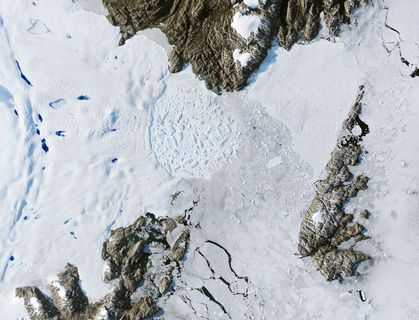
NASA's OMG at Thule Air Base, Greenland
Full Resolution:
TIFF
(16.96 MB)
JPEG
(565.8 kB)
|
|
|
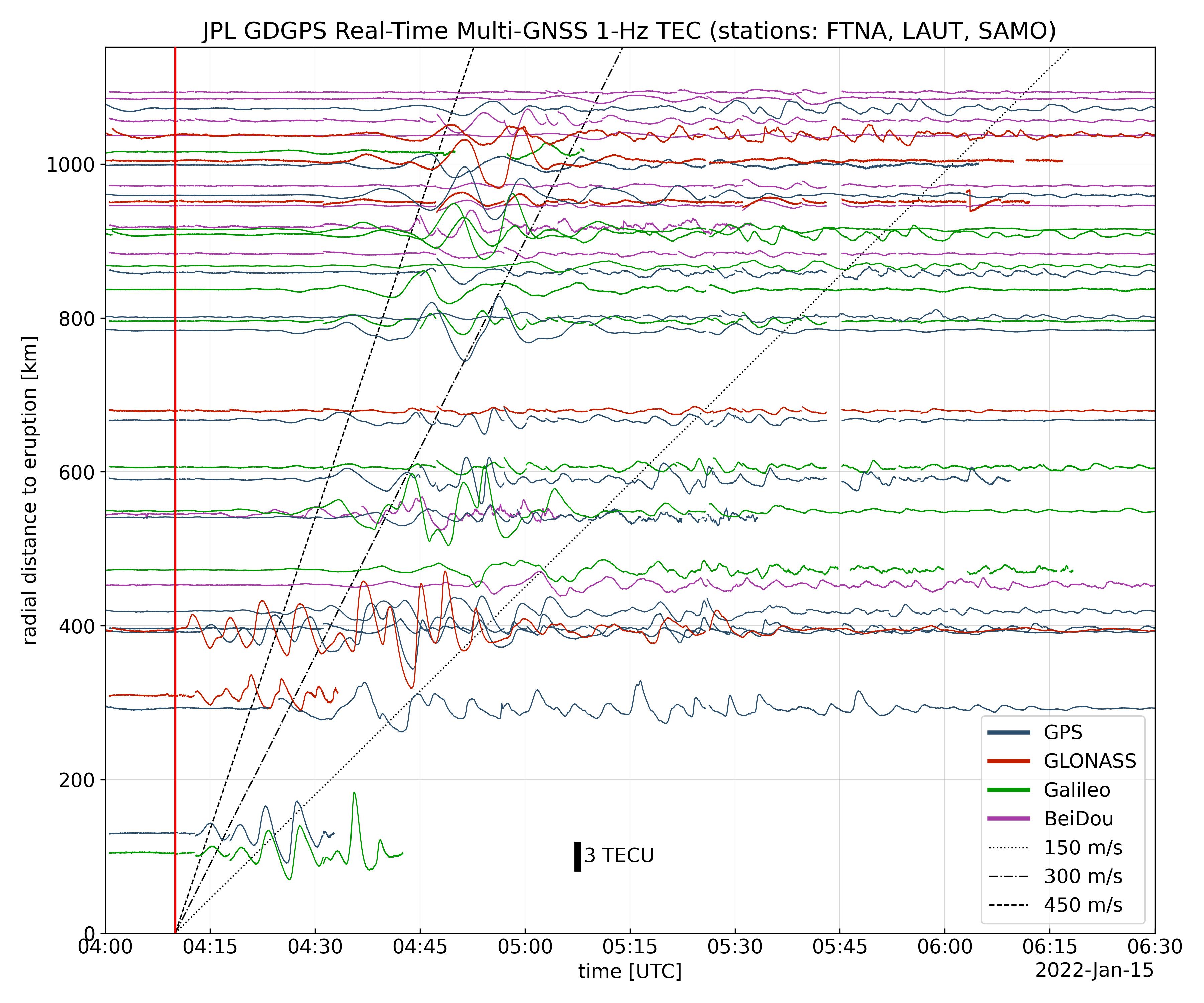
2022-01-27 |
Earth
|
Global Differential Global Positioning System (GDGPS)
|
|
3600x3000x3 |
|
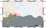
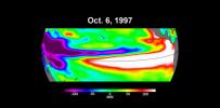
-
PIA24905:
-
Tonga Eruption Atmospheric Wave
Full Resolution:
TIFF
(3.165 MB)
JPEG
(1.025 MB)
|
|
|
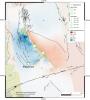
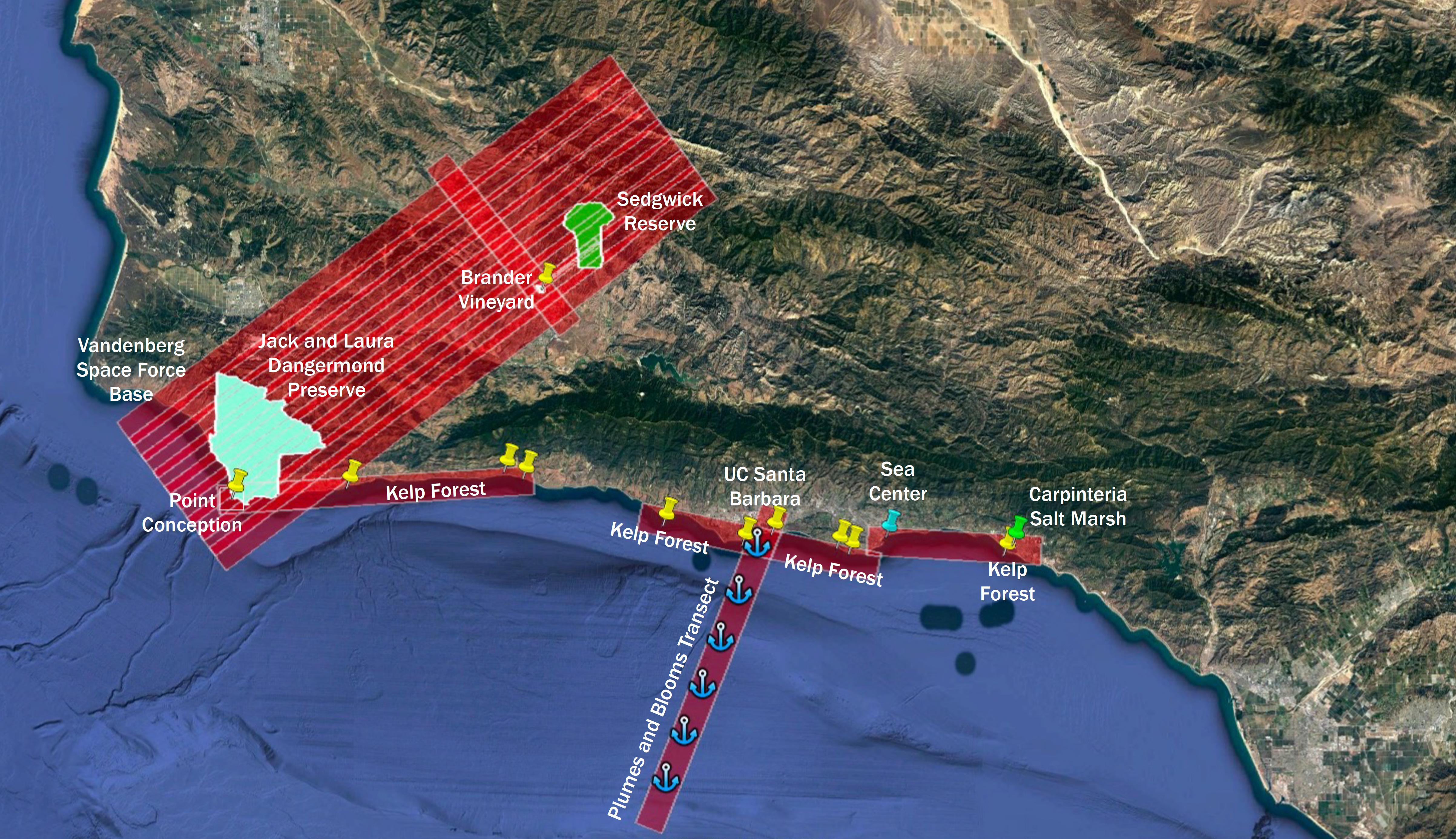
2022-04-18 |
Earth
|
Surface Biology and Geology High-Frequency Time Series (SHIFT)
|
|
4000x3000x3 |

|
-
PIA25143:
-
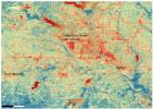
Aerial View of Point Conception, California, and the Dangermond Preserve
Full Resolution:
TIFF
(19 MB)
JPEG
(451.1 kB)
|
|
|
2022-04-18 |
Earth
|
Surface Biology and Geology High-Frequency Time Series (SHIFT)
|
|
4810x2774x3 |

|
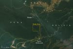
-
PIA25144:
-
SHIFT Campaign Research Plane Flight Area Map
Full Resolution:
TIFF
(39.35 MB)
JPEG
(1.602 MB)
|
|
|
2022-05-12 |
Earth
|
ECOSTRESS
|
|
3376x2477x3 |
|
-
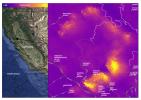
PIA24987:
-
ECOSTRESS Detects Heat Islands in Indian Heat Wave
Full Resolution:
TIFF
(25.1 MB)
JPEG
(2.193 MB)
|
|
|
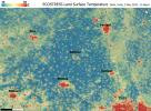
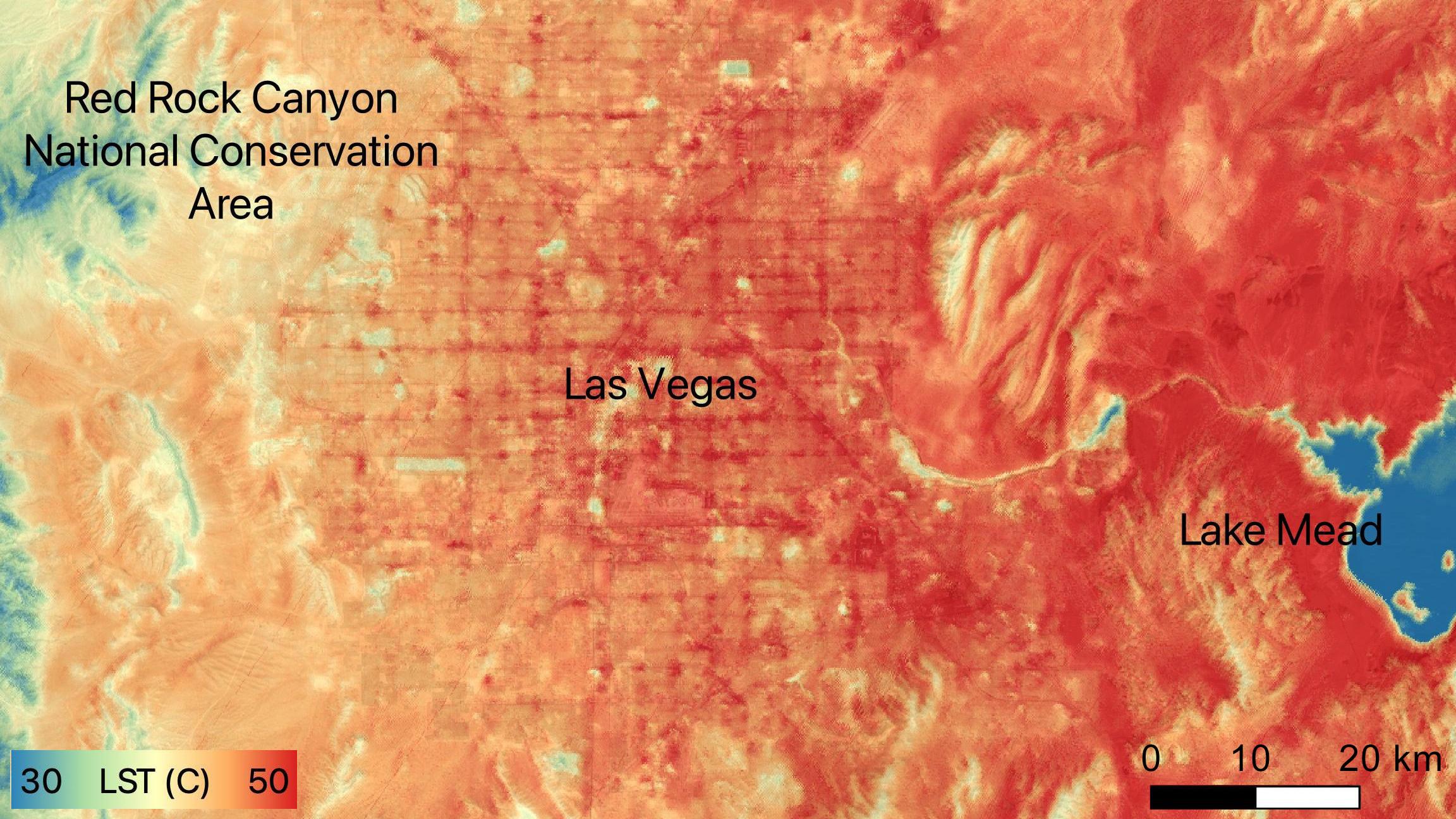
2022-06-15 |
Earth
|
ECOSTRESS
|
|
2304x1296x3 |

|
-
PIA24988:
-
NASA's ECOSTRESS Sees Las Vegas Streets Turn Up the Heat
Full Resolution:
TIFF
(8.962 MB)
JPEG
(479.4 kB)
|
|
|
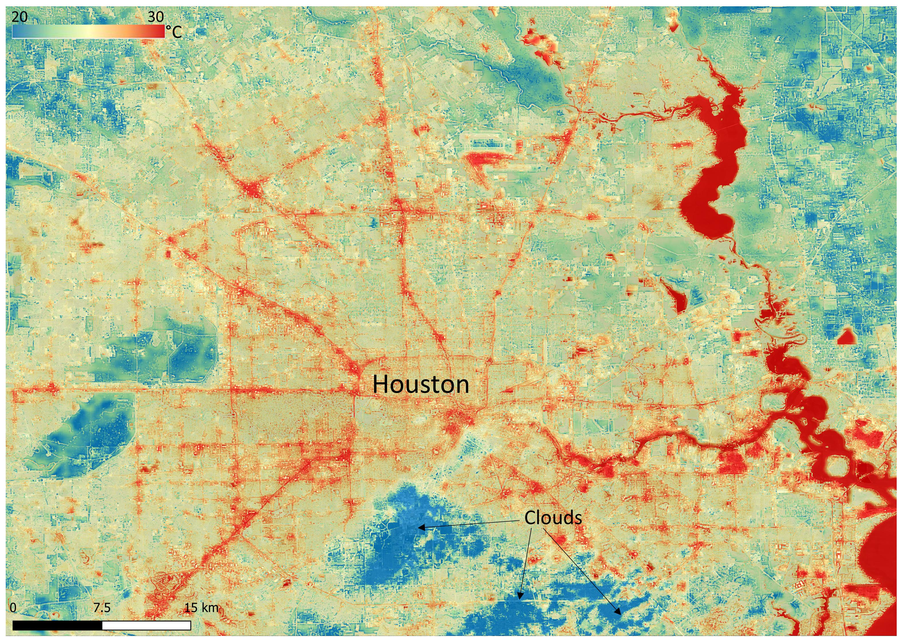
2022-06-22 |
Earth
|
ECOSTRESS
|
|
3161x2230x3 |
|
-
PIA25421:
-
NASA's ECOSTRESS Shows Surface Heat in Houston
Full Resolution:
TIFF
(21.16 MB)
JPEG
(1.711 MB)
|
|
|
2022-06-22 |
Earth
|
ECOSTRESS
|
|
3099x2201x3 |
|
-
PIA25422:
-
NASA's ECOSTRESS Shows Heat in Dallas and Fort Worth
Full Resolution:
TIFF
(20.47 MB)
JPEG
(2.22 MB)
|
|
|
2022-06-30 |
Earth
|
ECOSTRESS
|
|
3507x2480x3 |
|
-
PIA25280:
-
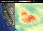
Colorado Fire
Full Resolution:
TIFF
(17.17 MB)
JPEG
(810.7 kB)
|
|
|
2022-06-30 |
Earth
|
ECOSTRESS
|
|
3507x2480x3 |
|
-
PIA25356:
-
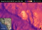
Sheep Fire
Full Resolution:
TIFF
(16.45 MB)
JPEG
(598.1 kB)
|
|
|
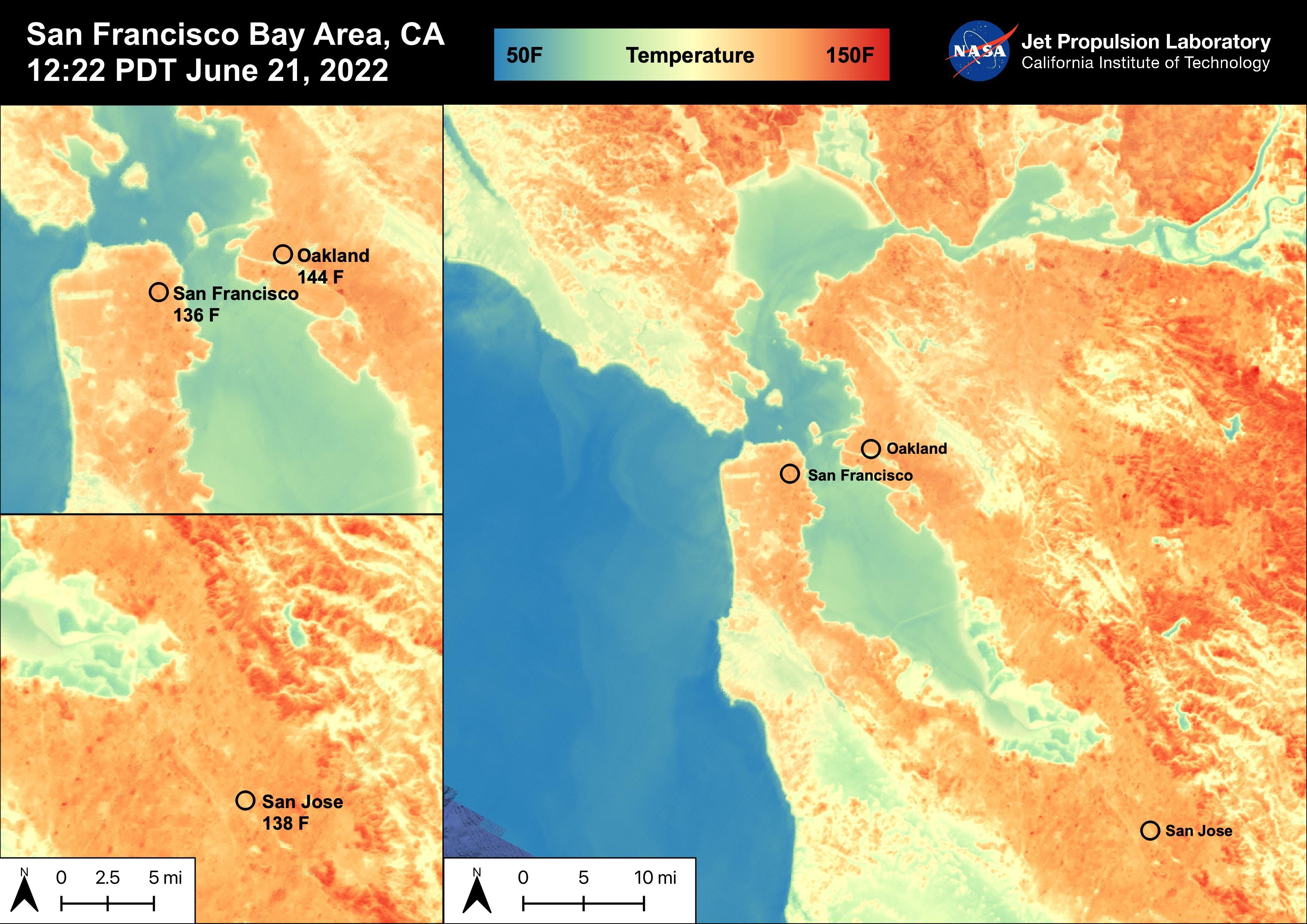
2022-06-30 |
Earth
|
ECOSTRESS
|
|
3507x2480x3 |
|
-
PIA25441:
-
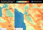
High Temperatures in the San Francisco Bay Area
Full Resolution:
TIFF
(21.01 MB)
JPEG
(919.1 kB)
|
|
|
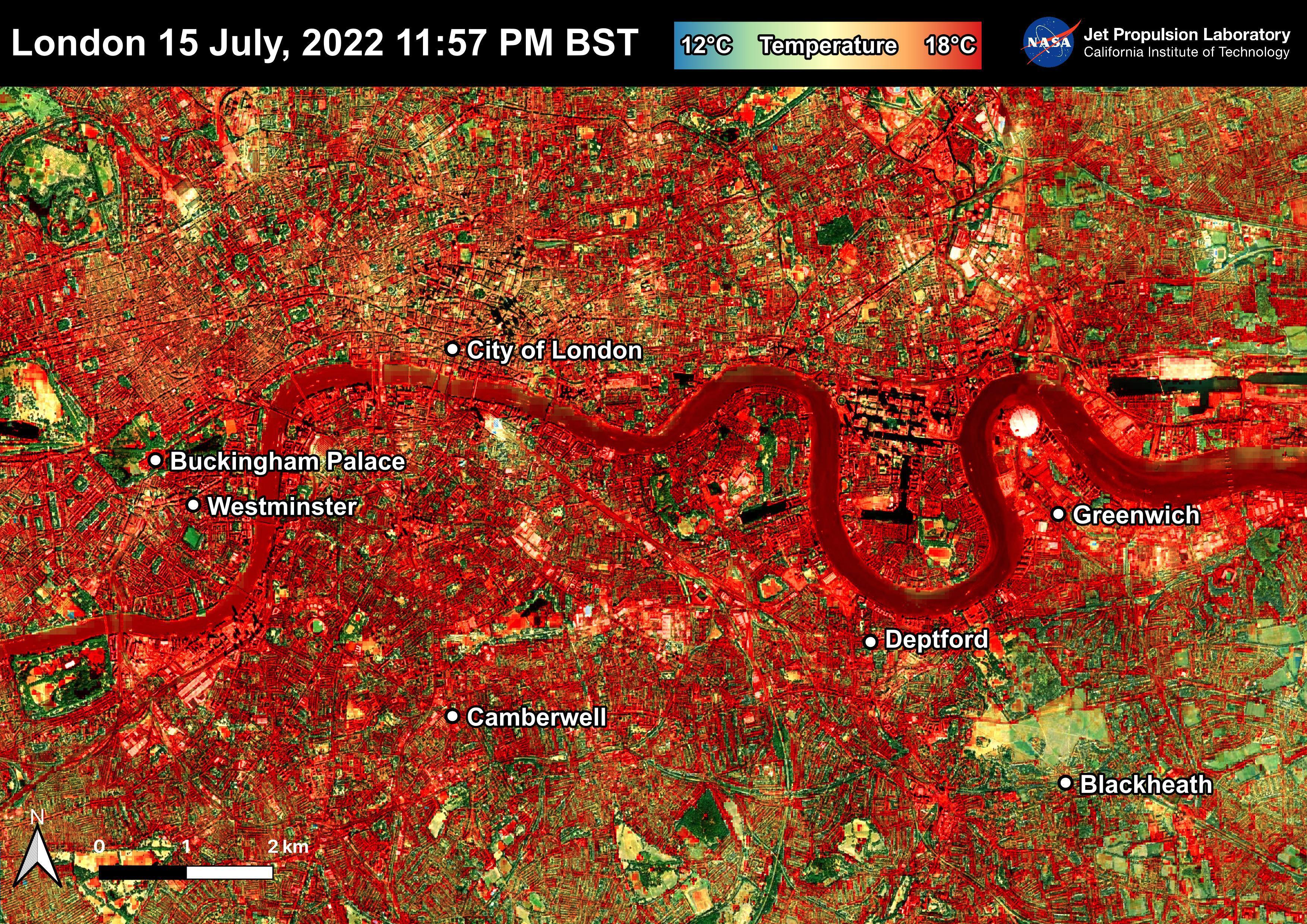
2022-07-22 |
Earth
|
ECOSTRESS
|
|
3507x2480x3 |
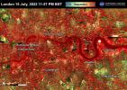
|
-
PIA25423:
-
NASA's ECOSTRESS Shows Overnight Heat in London
Full Resolution:
TIFF
(26.1 MB)
JPEG
(2.721 MB)
|
|
|
2022-08-04 |
Earth
|
ECOSTRESS
|
|
3507x2480x3 |
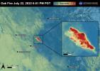
|
-
PIA25481:
-
The Oak Fire
Full Resolution:
TIFF
(21.67 MB)
JPEG
(865 kB)
|
|
|
2022-08-04 |
Earth
|
ECOSTRESS
|
|
3507x2480x3 |
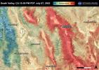
|
-
PIA25482:
-
Death Valley, CA
Full Resolution:
TIFF
(26.1 MB)
JPEG
(1.367 MB)
|
|
|
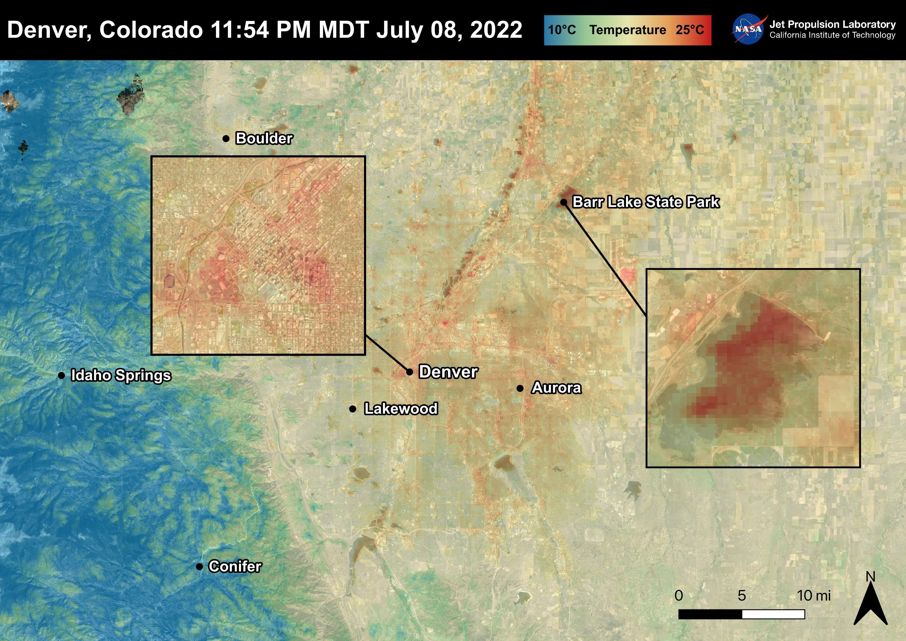
2022-08-04 |
Earth
|
ECOSTRESS
|
|
3507x2480x3 |
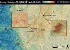
|
-
PIA25483:
-
Denver, CO
Full Resolution:
TIFF
(25.33 MB)
JPEG
(1.18 MB)
|
|
|
2022-08-04 |
Earth
|
ECOSTRESS
|
|
3507x2480x3 |
|
-
PIA25484:
-
The Electra Fire
Full Resolution:
TIFF
(23.43 MB)
JPEG
(1.034 MB)
|
|
|
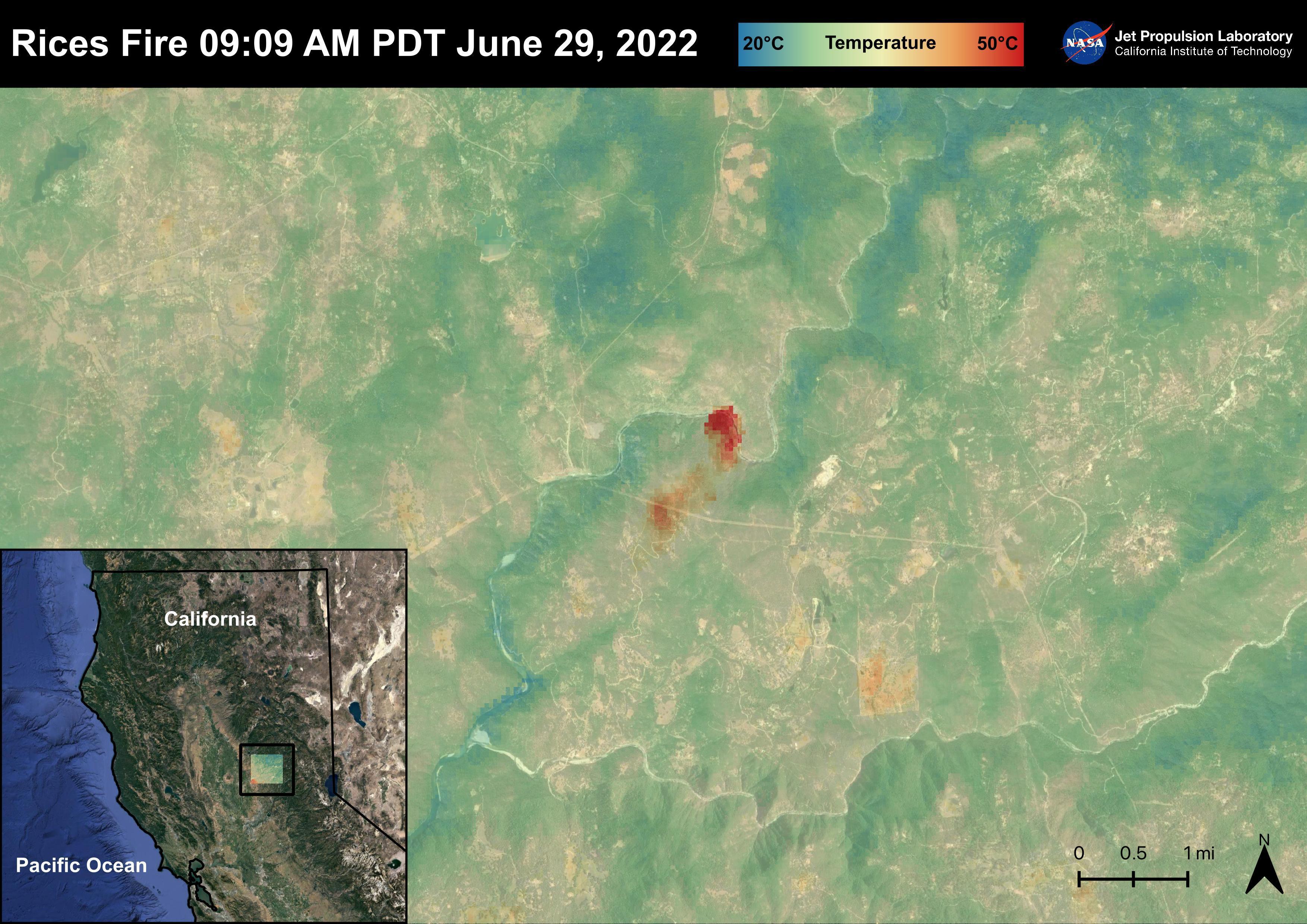
2022-08-04 |
Earth
|
ECOSTRESS
|
|
3507x2480x3 |
|
-
PIA25485:
-
The Rices Fire
Full Resolution:
TIFF
(23.34 MB)
JPEG
(1.067 MB)
|
|
|
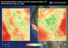
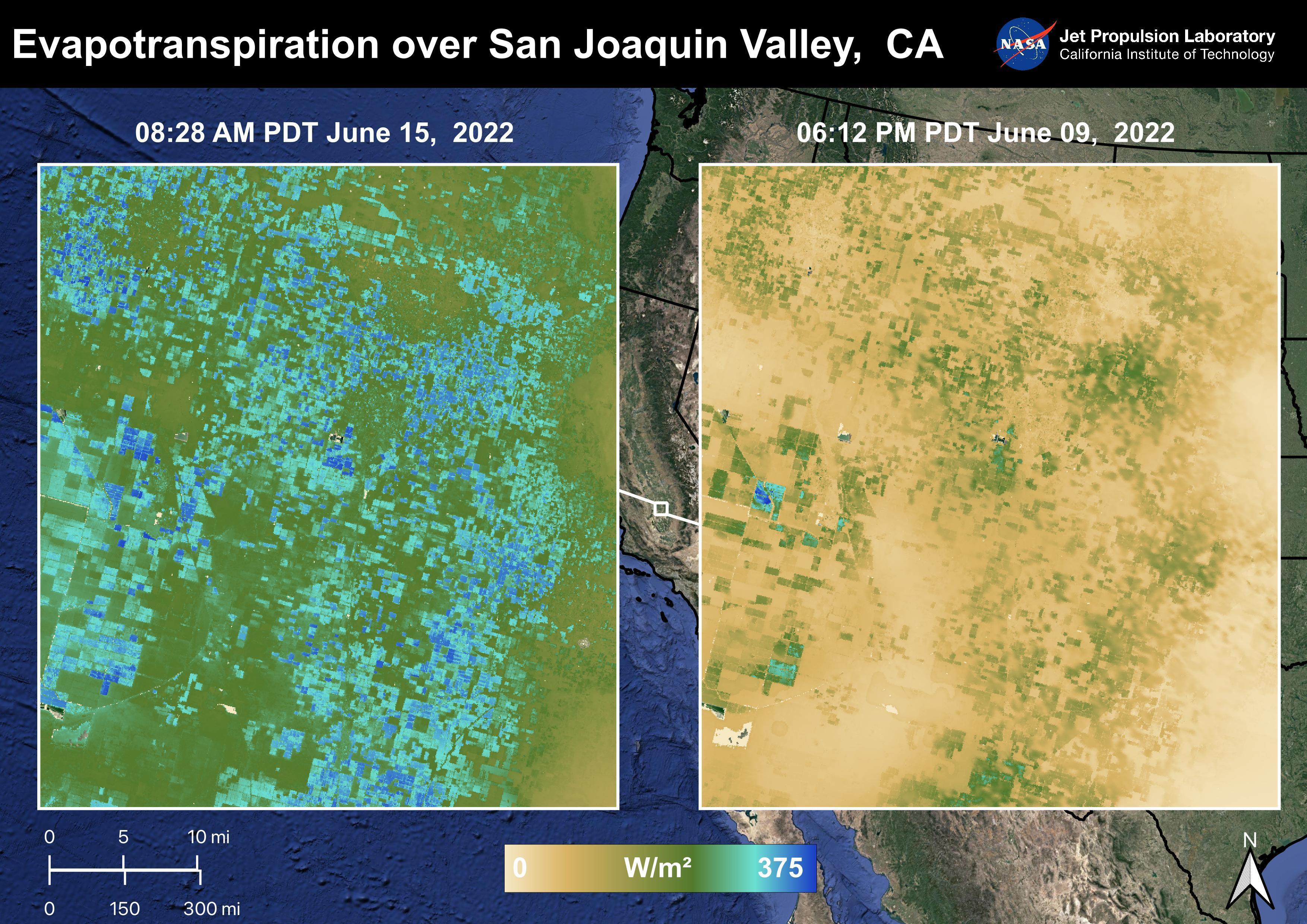
2022-08-04 |
Earth
|
ECOSTRESS
|
|
3507x2480x3 |

|
-
PIA25486:
-
Evapotranspiration over San Joaquin Valley
Full Resolution:
TIFF
(24.07 MB)
JPEG
(1.347 MB)
|
|
|
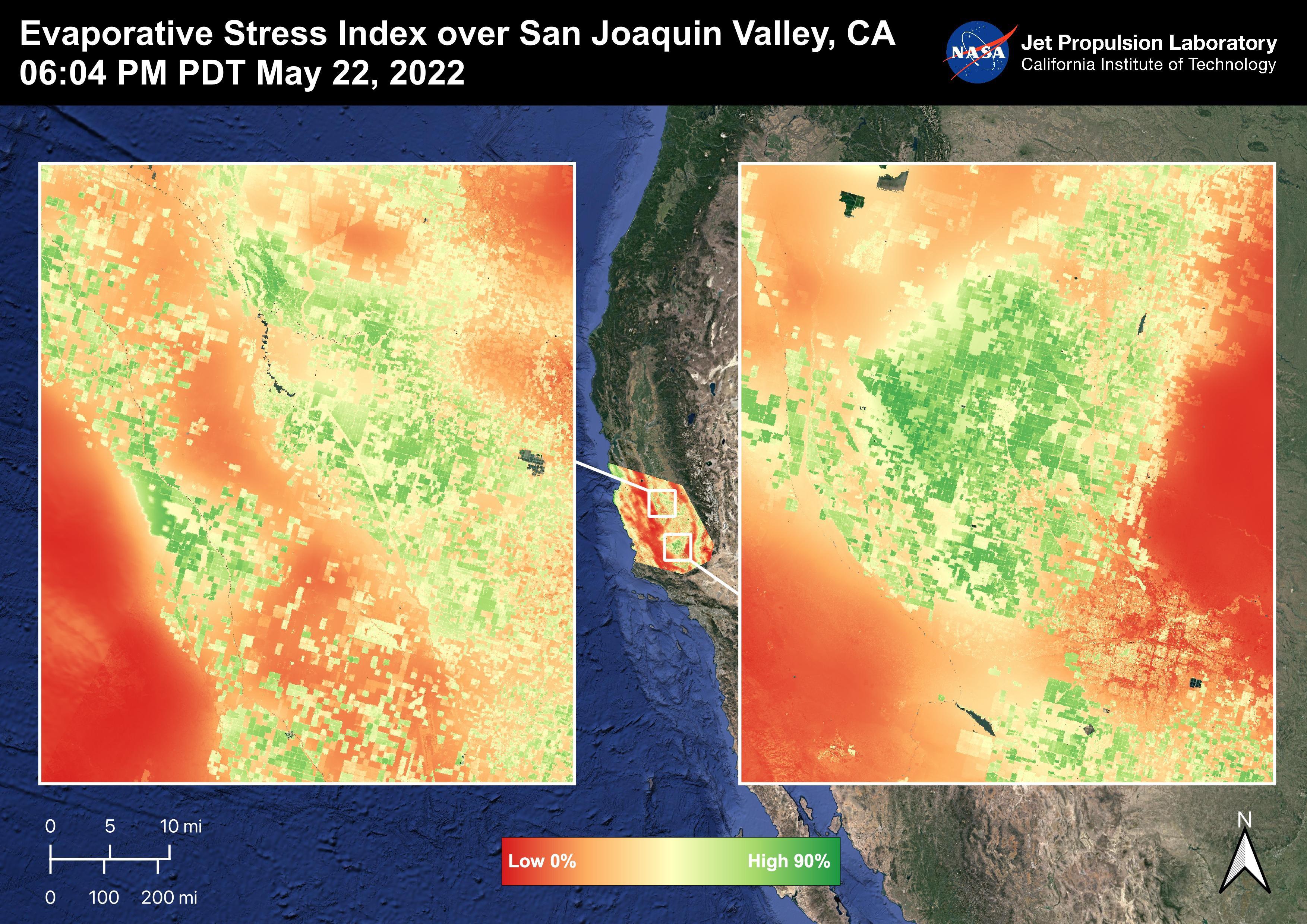
2022-08-04 |
Earth
|
ECOSTRESS
|
|
3507x2480x3 |
|
-
PIA25487:
-
Evaporative Stress Index over San Joaquin Valley
Full Resolution:
TIFF
(24.55 MB)
JPEG
(1.344 MB)
|
|
|
2022-08-04 |
Earth
|
ECOSTRESS
|
|
3507x2480x3 |
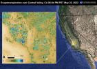
|
-
PIA25488:
-
Evapotranspiration over Central Valley
Full Resolution:
TIFF
(24.59 MB)
JPEG
(1.422 MB)
|
|
|
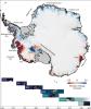
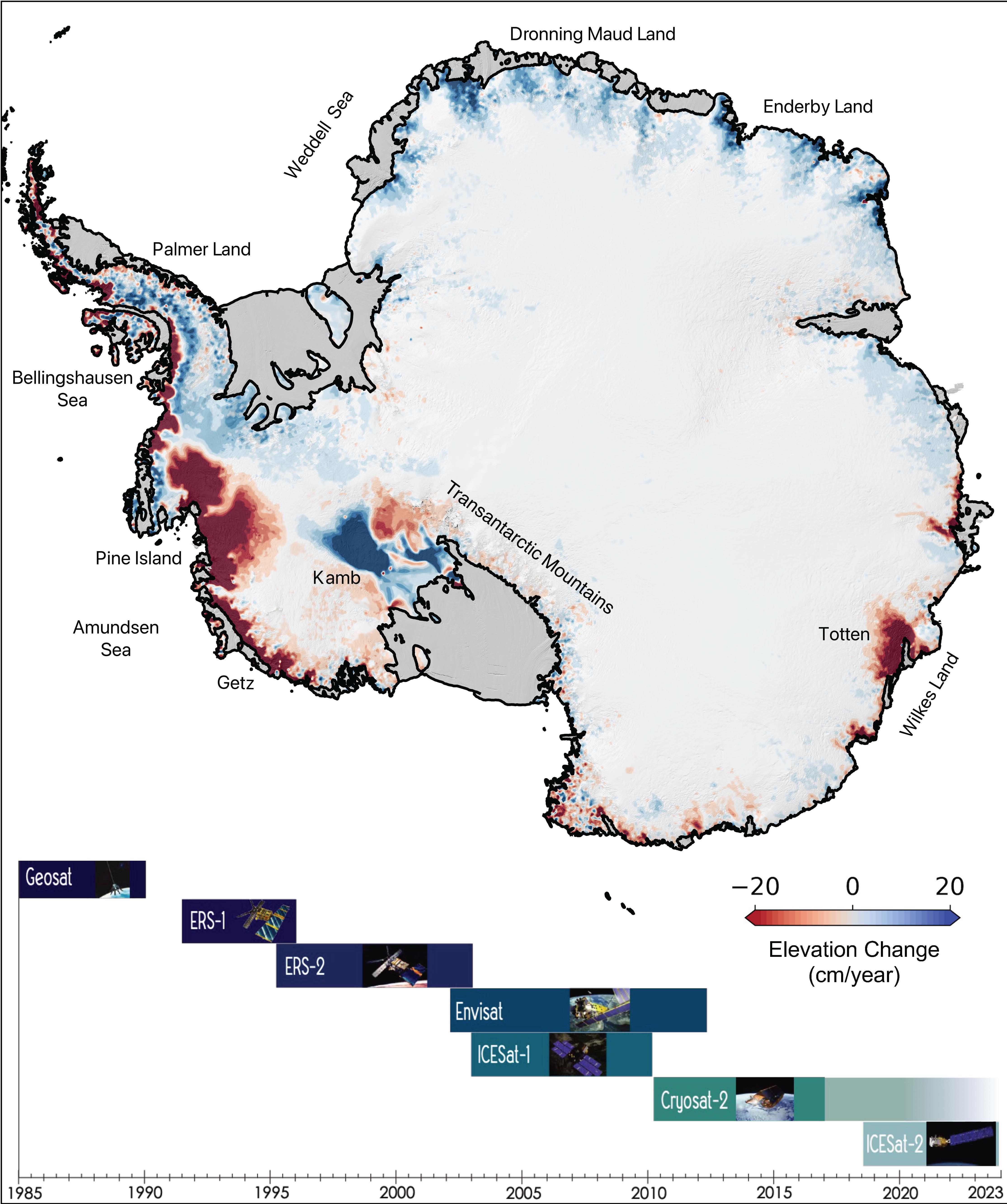
2022-08-10 |
Earth
|
|
|
4456x5324x3 |
|
-
PIA24990:
-
The Antarctic Ice Sheet's Changing Height
Full Resolution:
TIFF
(18.38 MB)
JPEG
(1.304 MB)
|
|
|
2022-10-11 |
Earth
|
S-MODE
|
|
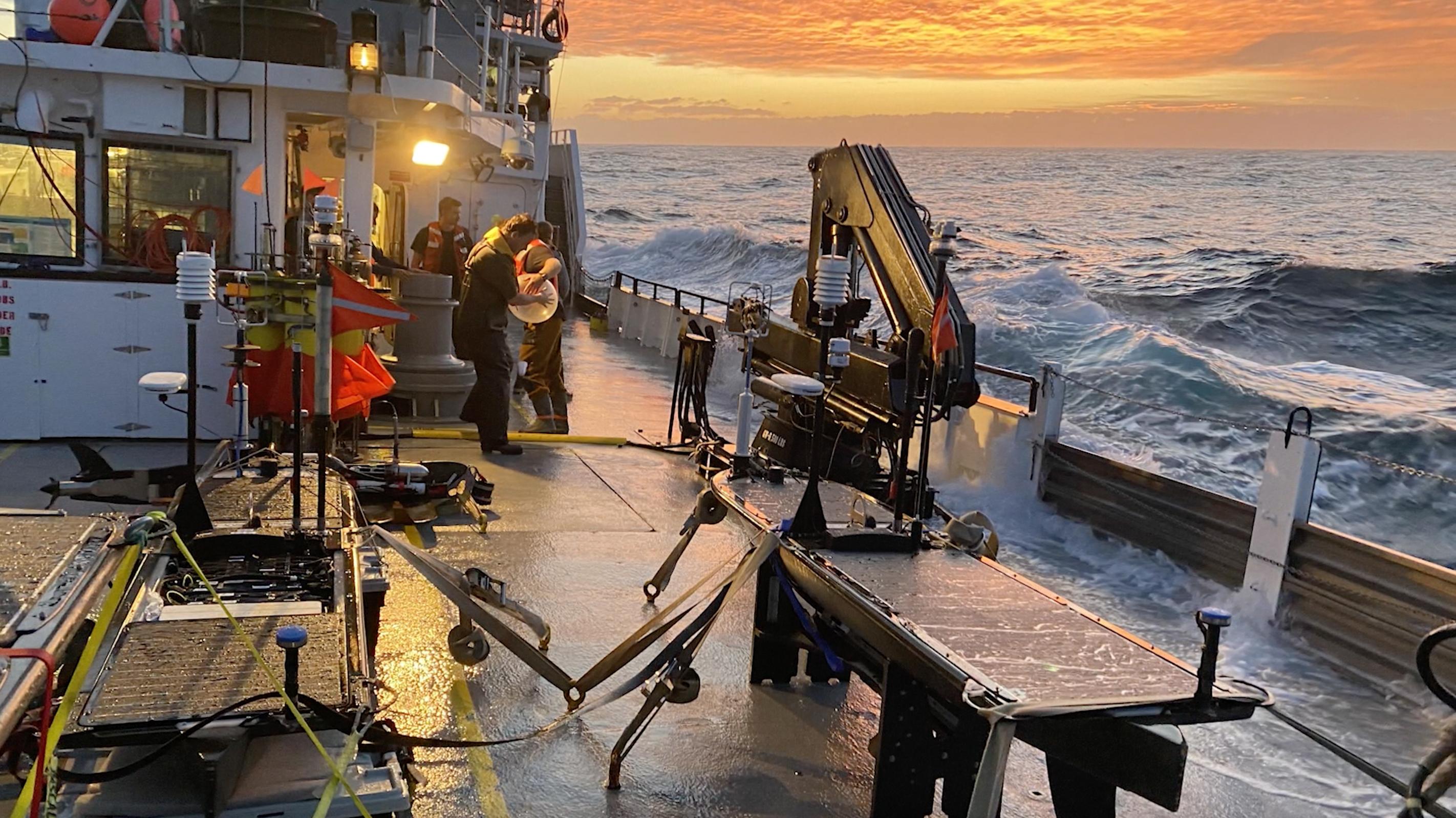
2844x1599x3 |

|
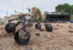
-
PIA25522:
-
High Seas at Sunset During S-MODE Field Campaign
Full Resolution:
TIFF
(13.65 MB)
JPEG
(611.5 kB)
|
|
|
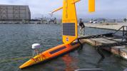
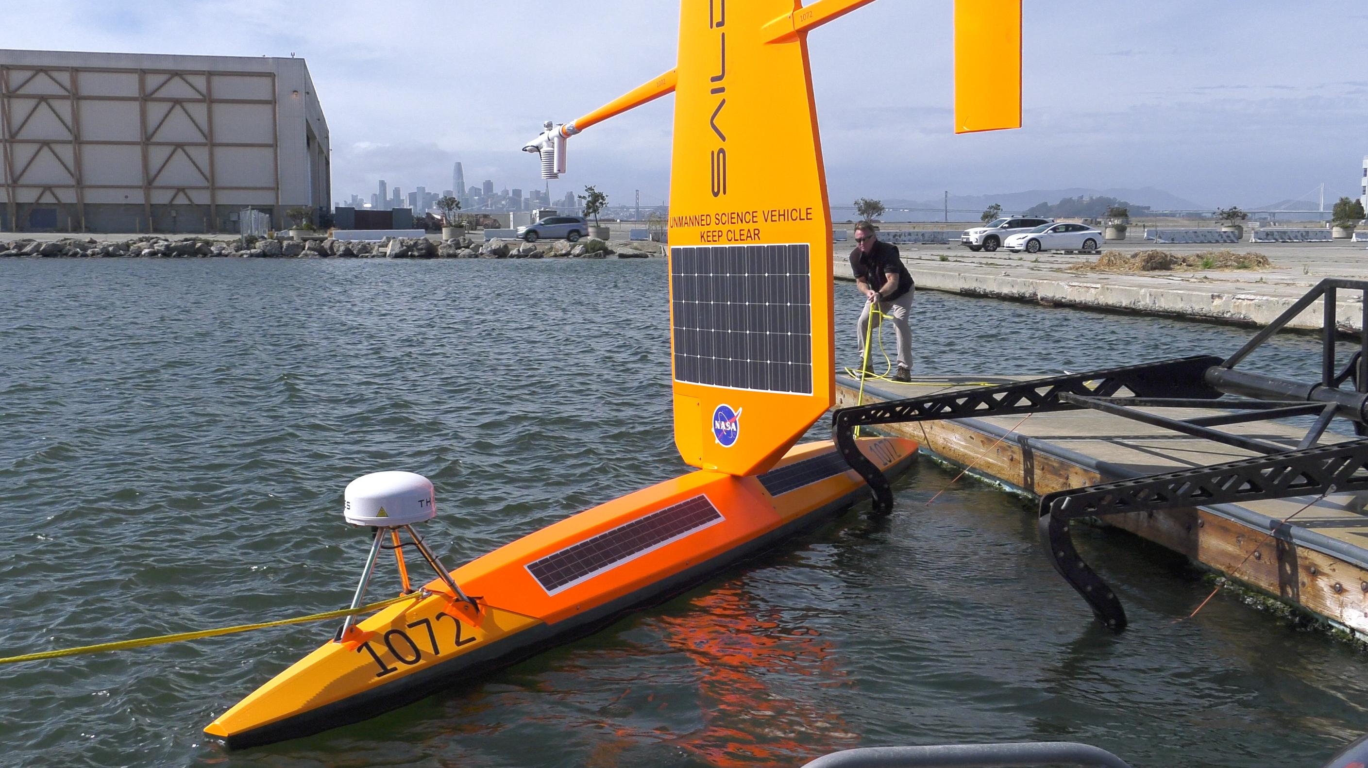
2022-10-11 |
Earth
|
S-MODE
|
|
2817x1582x3 |
|
-
PIA25523:
-
S-MODE Saildrone in San Francisco Waters
Full Resolution:
TIFF
(12.59 MB)
JPEG
(601.8 kB)
|
|
|
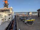
2022-10-11 |
Earth
|
S-MODE
|
|
4032x3024x3 |
|
-
PIA25524:
-
S-MODE Research Vessel and Marine Robots Prepare for Sea
Full Resolution:
TIFF
(29.16 MB)
JPEG
(1.602 MB)
|
|
|
2022-11-14 |
Earth
|
Surface Water and Ocean Topography (SWOT)
|
|
1920x1080x3 |
|
-
PIA25561:
-
SWOT Satellite will Improve Clarity and Detail of Sea Height Measurements
Full Resolution:
TIFF
(3.673 MB)
JPEG
(154 kB)
|
|
|
2023-03-17 |
Earth
|
|
|
3300x2550x3 |
|
-
PIA25775:
-
30 Years of Sea Level Rise
Full Resolution:
TIFF
(5.404 MB)
JPEG
(446.5 kB)
|
|
|
2023-03-24 |
Earth
|
|
|
1440x1570x3 |

|
-
PIA25773:
-
Sea Level Visualization of Gulf Stream
Full Resolution:
TIFF
(2.24 MB)
JPEG
(159 kB)
|
|
|
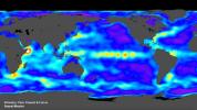
2023-05-12 |
Earth
|
Sentinel-6/Jason-CS
|
|
875x415x3 |
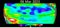
|
-
PIA25776:
-
Early El Niño Signs
Full Resolution:
TIFF
(598.3 kB)
JPEG
(51.43 kB)
|
|
|
2023-05-15 |
Earth
|
|
|
1440x700x3 |
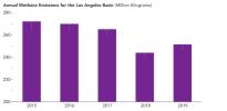
|
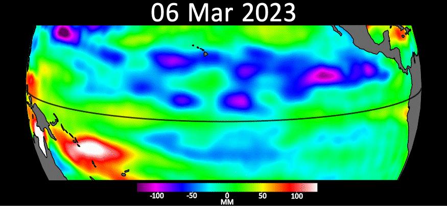
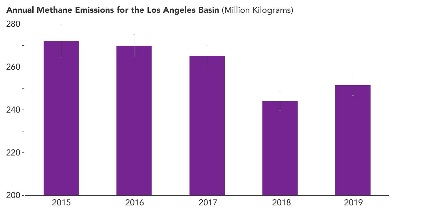
-
PIA25863:
-
Declining Methane Emissions in the Los Angeles Basin
Full Resolution:
TIFF
(181.3 kB)
JPEG
(46.55 kB)
|
|
|
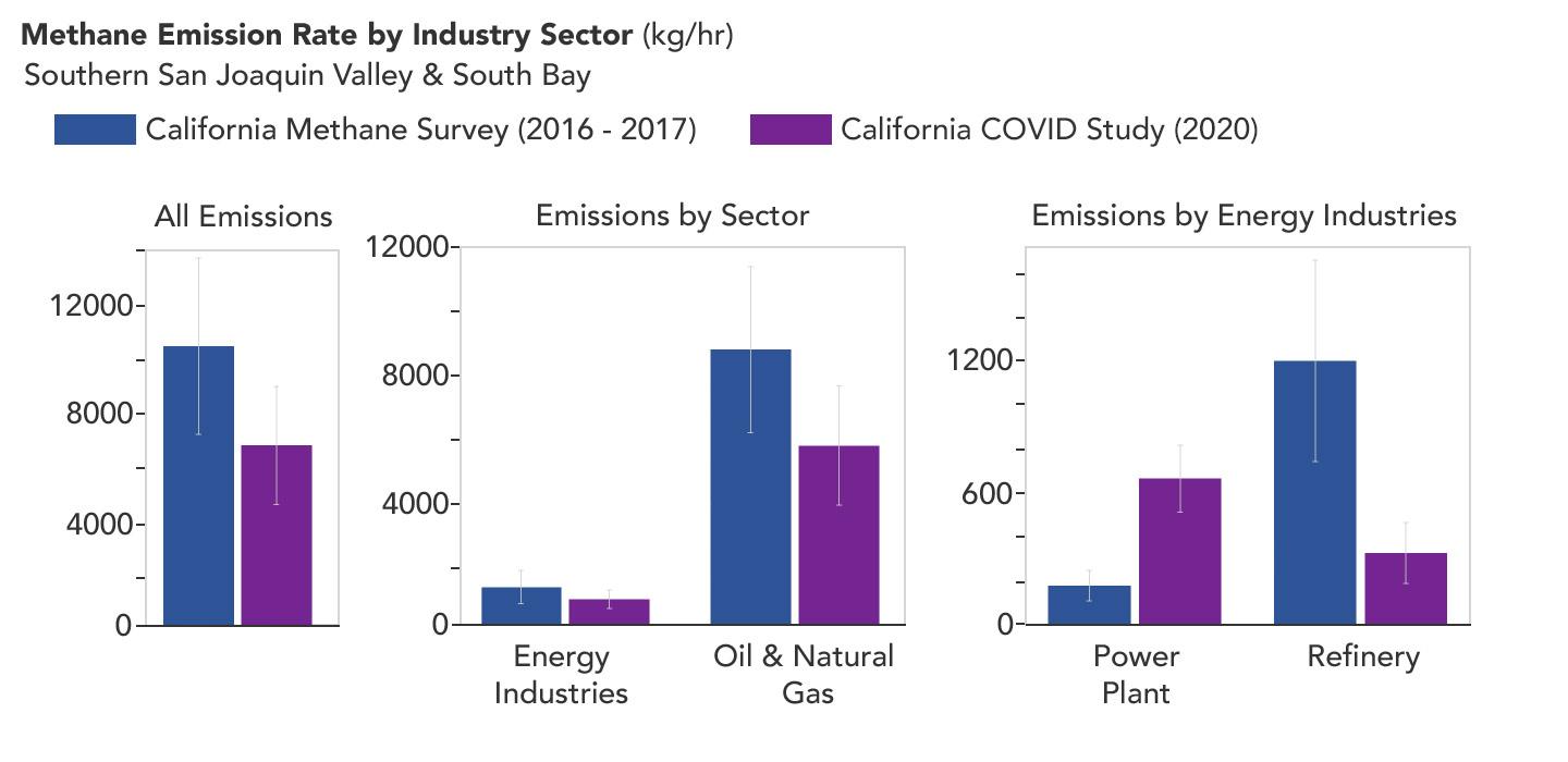
2023-05-15 |
Earth
|
|
|
1440x700x3 |

|
-
PIA25864:
-
Declining Methane Emissions at California Oil Fields and Refineries
Full Resolution:
TIFF
(325.1 kB)
JPEG
(73.03 kB)
|
|
|
2023-06-22 |
Earth
|
Terra
|
|
2741x2514x3 |
|
-
PIA25946:
-
Folded Rocks, Iran
Full Resolution:
TIFF
(20.68 MB)
JPEG
(1.742 MB)
|
|
|
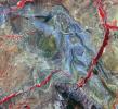
2023-06-27 |
Earth
|
Surface Water and Ocean Topography (SWOT)
|
|
1125x1122x3 |
|
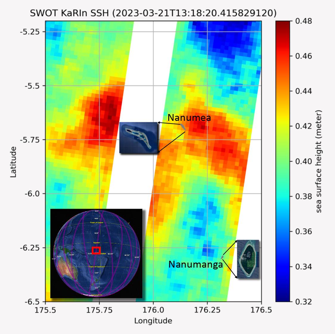
-
PIA25777:
-
SWOT Measures Tuvalu Sea Level
Full Resolution:
TIFF
(1.862 MB)
JPEG
(131.7 kB)
|
|
|
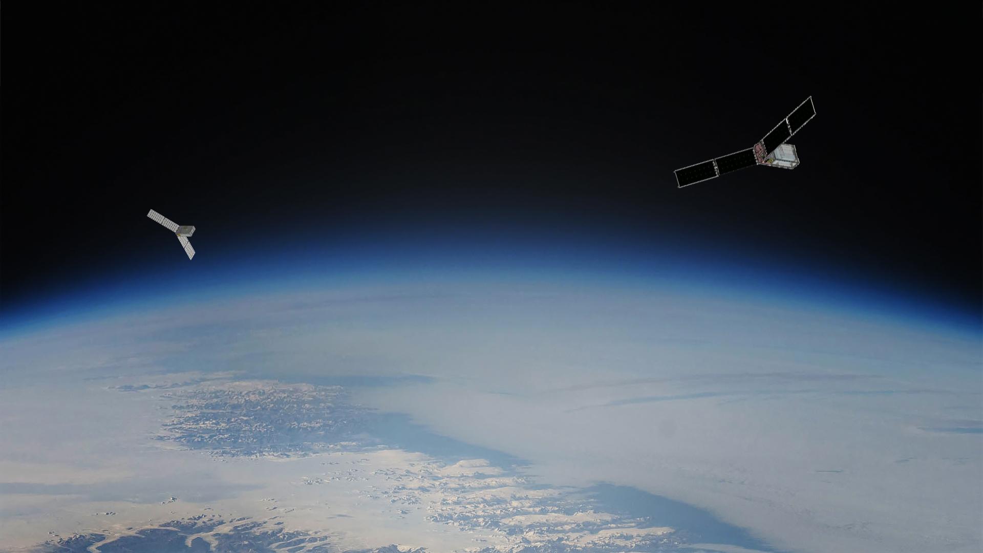
2023-08-14 |
Earth
|
Polar Radiant Energy in the Far-InfraRed Experiment (PREFIRE)
|
|
1920x1080x3 |
|
-
PIA25778:
-
PREFIRE Satellite Illustration
Full Resolution:
TIFF
(3.12 MB)
JPEG
(92.14 kB)
|
|
|
2023-10-18 |
Earth
|
Sentinel-6/Jason-CS
|
|
1586x783x3 |
|
-
PIA26099:
-
Comparing Sea Level During El Niño Events
Full Resolution:
TIFF
(303.4 kB)
JPEG
(200.3 kB)
|
|
|
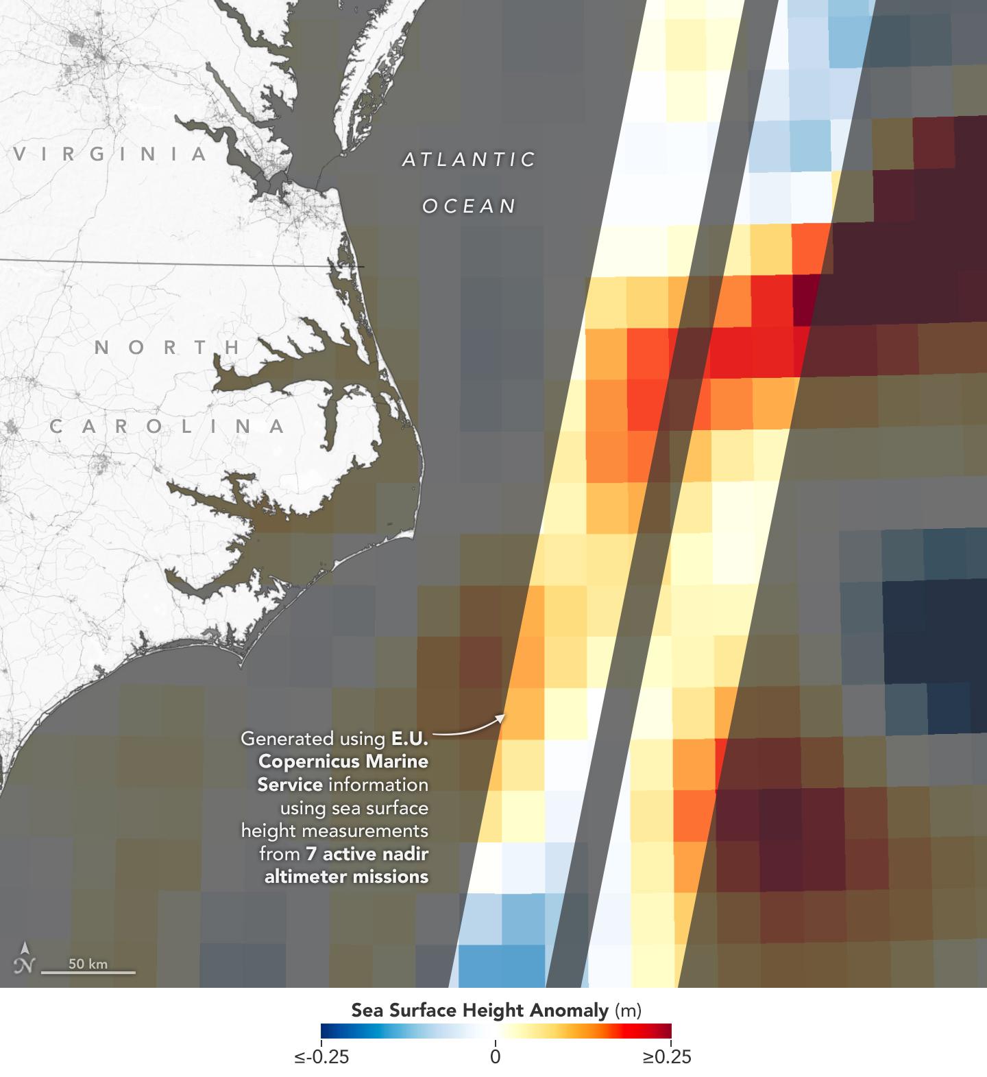
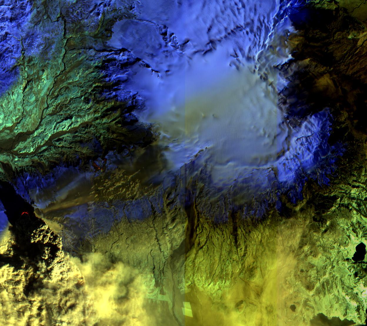
2023-10-27 |
Earth
|
NISAR
|
|
973x913x3 |
|
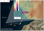
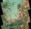
-
PIA26111:
-
Composite of Brazil's 'Arc of Deforestation' Shows Imagery NISAR Will Produce
Full Resolution:
TIFF
(2.666 MB)
JPEG
(396.6 kB)
|
|
|
2025-07-03 |
Earth
|
NISAR
|
|
1800x1275x3 |
|
-
PIA26112:
-
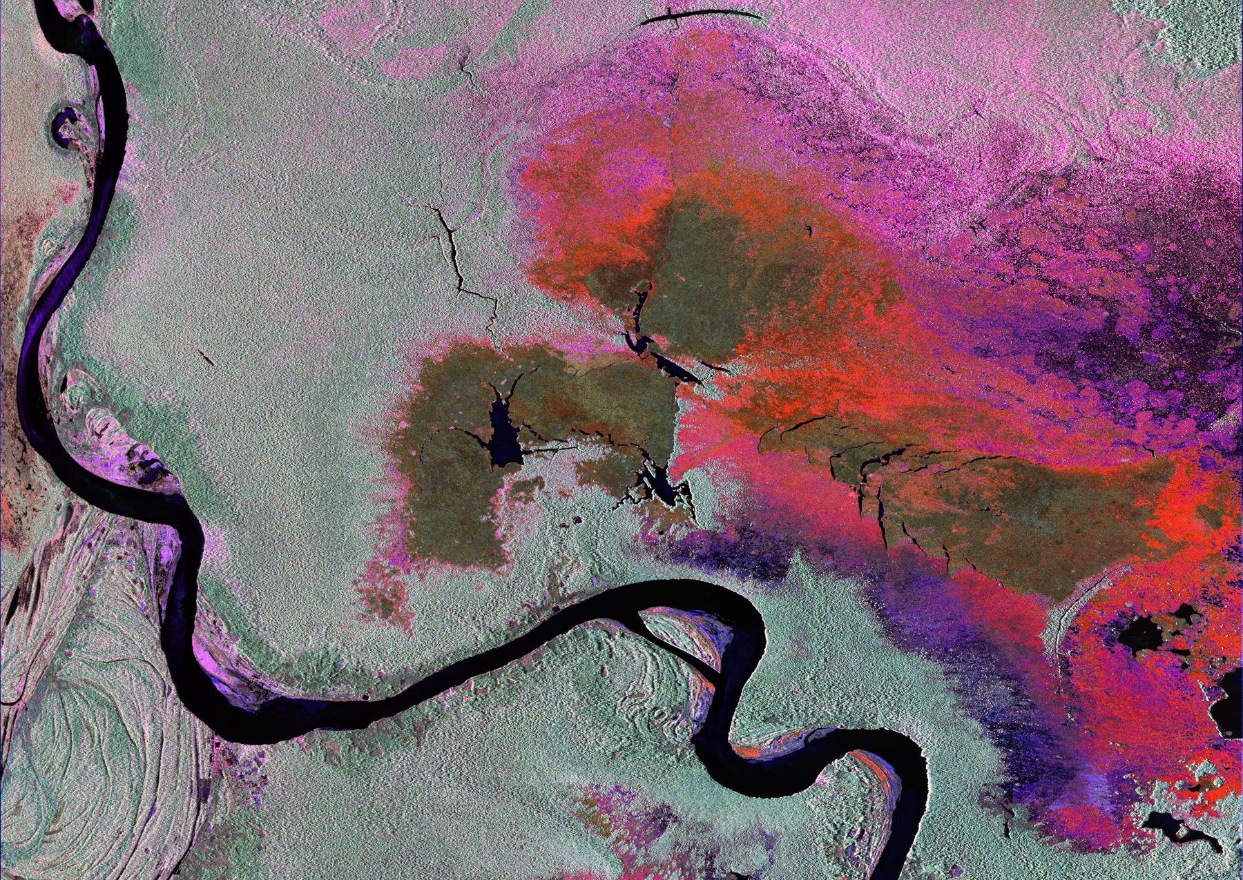
Radar Image of Amazonian Flooding Similar to Future NISAR Imagery
Full Resolution:
TIFF
(6.888 MB)
JPEG
(808.4 kB)
|
|
|
2024-01-17 |
Earth
|
Landsat
|
|
1440x960x3 |
|
-
PIA26117:
-
Retreat of Greenland's Jakobshavn Isbrae Glacier
Full Resolution:
TIFF
(4.134 MB)
JPEG
(231.5 kB)
|
|
|
2024-01-17 |
Earth
|
Landsat
|
|
1440x1100x3 |
|
-
PIA26118:
-
Retreat of Greenland's Zachariae Isstrom Glacier
Full Resolution:
TIFF
(4.298 MB)
JPEG
(315.8 kB)
|
|
|
2024-03-21 |
Earth
|
TOPEX/Poseidon
Sentinel-6 Michael Freilich
|
|
3300x2550x3 |
|
-
PIA26183:
-
2023 Sea Level Rise Update
Full Resolution:
TIFF
(5.199 MB)
JPEG
(459.8 kB)
|
|
|
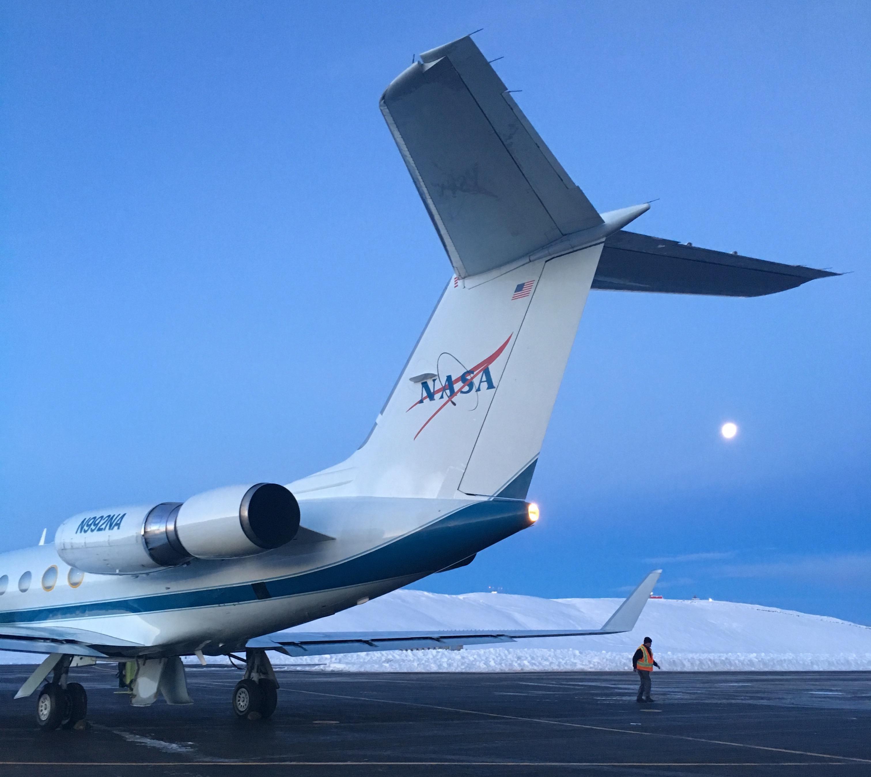
2024-05-15 |
Earth
|
Polar Radiant Energy in the Far-InfraRed Experiment (PREFIRE)
|
|
1583x891x3 |
|
-
PIA26185:
-
PREFIRE CubeSat in Earth Orbit (Artist's Concept)
Full Resolution:
TIFF
(1.666 MB)
JPEG
(47.7 kB)
|
|
|
2024-05-21 |
Earth
|
Polar Radiant Energy in the Far-InfraRed Experiment (PREFIRE)
|
|
6720x4480x3 |

|
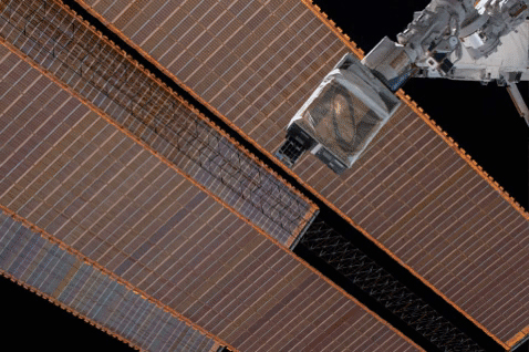
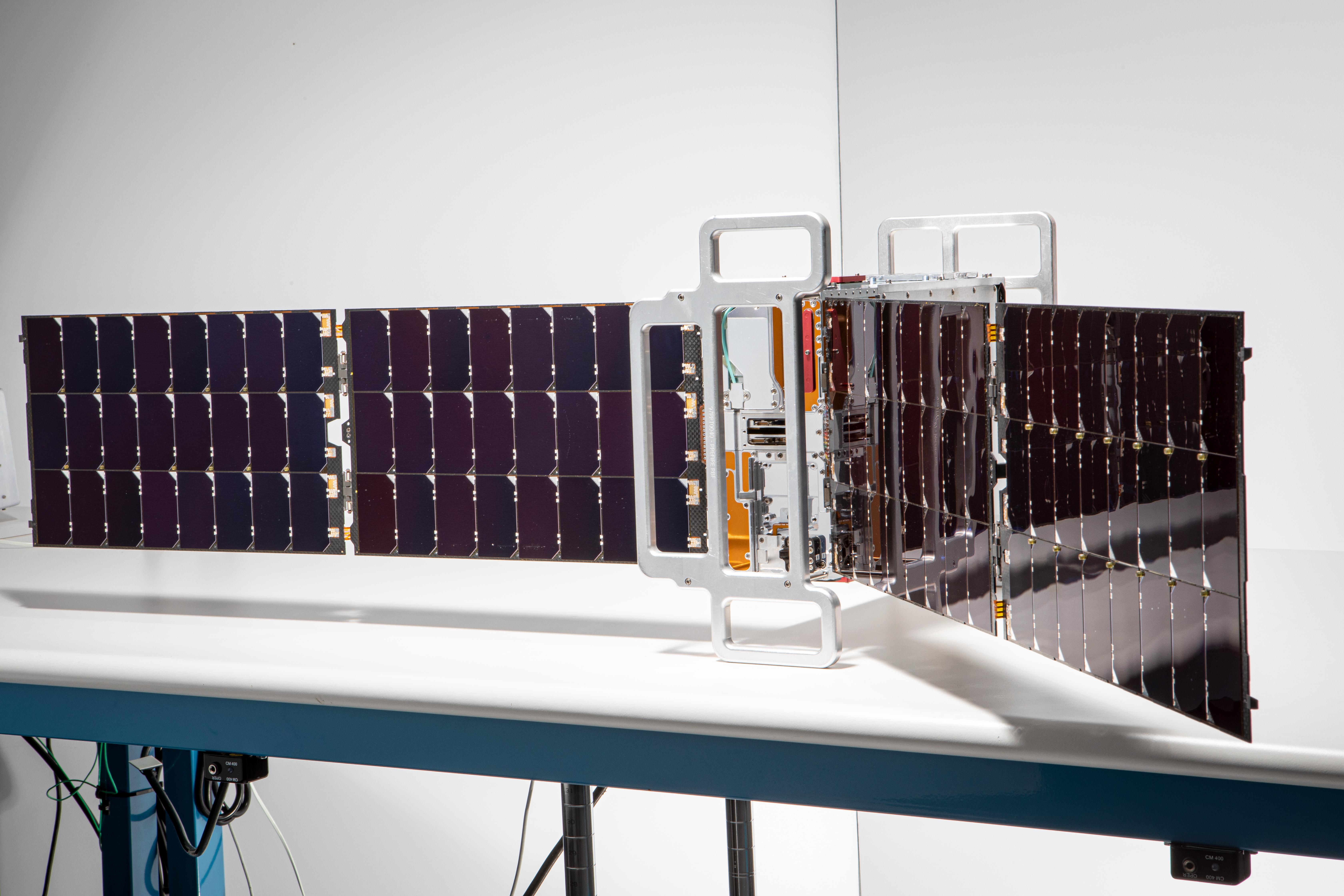
-
PIA26186:
-
PREFIRE CubeSat Image
Full Resolution:
TIFF
(56.6 MB)
JPEG
(2.543 MB)
|
|
|
2024-07-19 |
Earth
|
|
|
1654x1578x3 |
|
-
PIA26120:
-
Meandering Path of Earth's Spin Axis
Full Resolution:
TIFF
(362.3 kB)
JPEG
(108.7 kB)
|
|
|
2024-09-13 |
Earth
|
ECOSTRESS
|
|
3507x2480x3 |
|
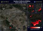
-
PIA26187:
-
Southern California Wildfires Captured by NASA's ECOSTRESS
Full Resolution:
TIFF
(19.8 MB)
JPEG
(1.341 MB)
|
|
|
2024-10-17 |
Earth
|
|
|
4928x3264x3 |

|
-
PIA26409:
-
Cryoconite Holes on Matanuska Glacier
Full Resolution:
TIFF
(24.12 MB)
JPEG
(923.8 kB)
|
|
|
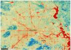
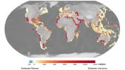
2024-12-11 |
Earth
|
|
|
7831x4404x3 |
|
-
PIA26491:
-
Projections of Saltwater Intrusion in Coastal Watersheds by 2100
Full Resolution:
TIFF
(26.01 MB)
JPEG
(2.08 MB)
|
|
|
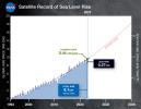
2025-03-13 |
Earth
|
TOPEX/Poseidon
Sentinel-6 Michael Freilich
|
|
3300x2550x3 |

|
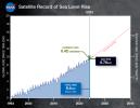
-
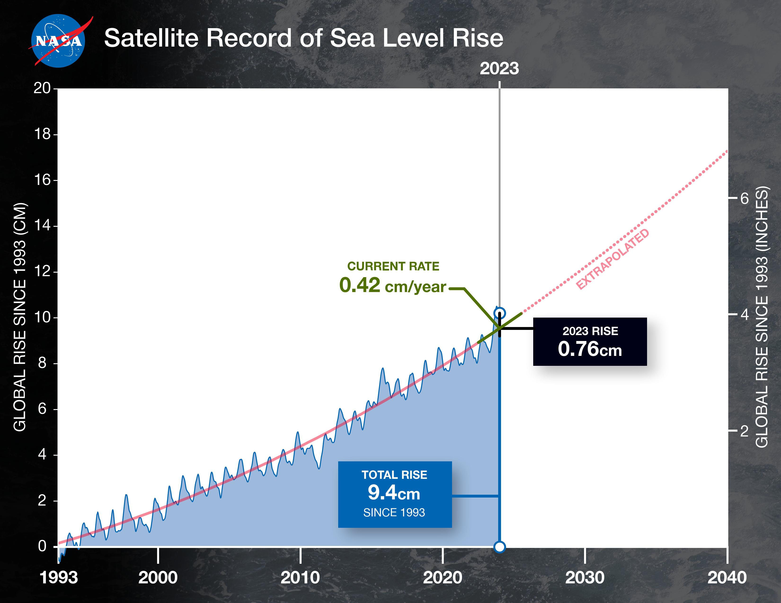
PIA26189:
-
Satellite Record of Sea Level Rise From 1993 to 2024
Full Resolution:
TIFF
(5.236 MB)
JPEG
(464.9 kB)
|
|
|
2025-07-03 |
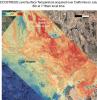
Earth
|
ECOSTRESS
|
|
3507x2480x3 |

|
-
PIA26190:
-
ECOSTRESS Captures Paris During Europe Heat Wave
Full Resolution:
TIFF
(24.59 MB)
JPEG
(3.007 MB)
|
|
|
2010-04-21 |
Earth
|
Earth Observing-1 (EO-1)
|
Advanced Land Imager (ALI)
|
1248x1110x3 |

|
-
PIA13053:
-
NASA Satellite Observes Iceland's Eyjafjallajökull Volcano in Infrared
Full Resolution:
TIFF
(4.161 MB)
JPEG
(231.8 kB)
|
|
|
2014-09-03 |
Earth
|
Earth Observing-1 (EO-1)
|
Advanced Land Imager (ALI)
|
1157x1024x3 |
|
-
PIA18796:
-
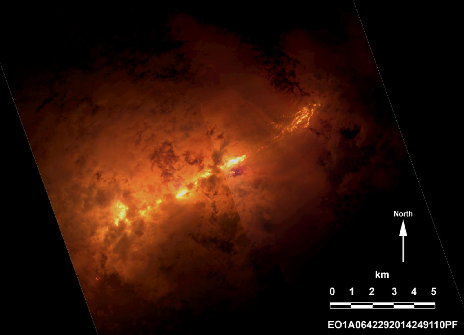
NASA Spacecraft Eyes Iceland Volcanic Eruption
Full Resolution:
TIFF
(3.556 MB)
JPEG
(67.52 kB)
|
|
|
2014-09-09 |
Earth
|
Earth Observing-1 (EO-1)
|
Advanced Land Imager (ALI)
|
1600x1155x3 |
|
-
PIA18802:
-
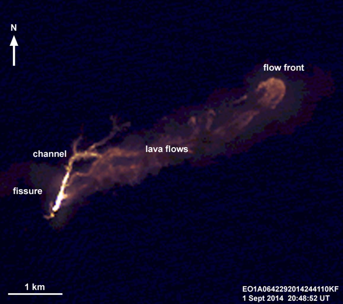
Progress of Icelandic Lava Flows Charted by NASA's EO-1 Spacecraft
Full Resolution:
TIFF
(5.546 MB)
JPEG
(84.23 kB)
|
|
|
2014-09-15 |
Earth
|
Earth Observing-1 (EO-1)
|
Advanced Land Imager (ALI)
|
1158x879x3 |
|
-
PIA18211:
-
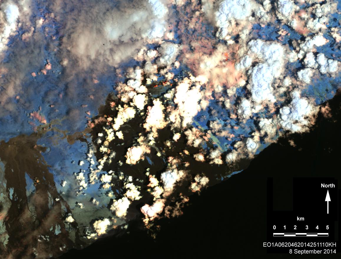
Hawaii Lava Threat Closely Monitored by NASA EO-1 Spacecraft
Full Resolution:
TIFF
(3.055 MB)
JPEG
(160.5 kB)
|
 Planetary Data System


