Figure A
Main image - maximum resolution version, 43783 x 14997 pixels (152 MB)
Figure A image - maximum resolution version, 43783 x 14997 pixels (236 MB)
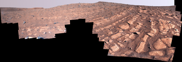
Scientists think that the bands of rocks seen in this image may have been formed by a very fast, deep river – the first of its kind evidence has been found for on Mars. NASA's Perseverance Mars rover captured this mosaic at a location nicknamed "Skrinkle Haven" using its Mastcam-Z camera between Feb. 28 and March 9, 2023 (between the 721st and 729th Martian days, or sols, of the mission).
The mosaic is made up of 203 individual images that were stitched together after being sent back from Mars. This natural color view is approximately how the scene would appear to an average person if they were on Mars.
Figure A is an enhanced color view that exaggerates subtle color differences in the scene.
"Skrinkle Haven" offers the clearest example of these curved rock layers – called "the curvilinear unit" – that had previously only been seen from space. Scientists are now debating what kind of powerfully flowing water formed those curves: a river like the Mississippi, which winds snakelike across the landscape, or a braided river like Nebraska's Platte, which forms small islands of sediment called sandbars.
When viewed from the ground, the curved layers are arranged in rows, and appear to ripple out across the landscape. They could be the remnants of a river's banks that shifted over time – or the remnants of sandbars that formed in the river. The layers were likely much taller in the past; scientists suspect that after these piles of sediment turned to rock, they were sand-blasted by wind over the course of eons and carved down to their present size.
Arizona State University leads the operations of the Mastcam-Z instrument, working in collaboration with Malin Space Science Systems in San Diego, on the design, fabrication, testing, and operation of the cameras, and in collaboration with the Niels Bohr Institute of the University of Copenhagen on the design, fabrication, and testing of the calibration targets.
A key objective for Perseverance's mission on Mars is astrobiology, including the search for signs of ancient microbial life. The rover will characterize the planet's geology and past climate, pave the way for human exploration of the Red Planet, and be the first mission to collect and cache Martian rock and regolith (broken rock and dust).
Subsequent NASA missions, in cooperation with ESA (European Space Agency), would send spacecraft to Mars to collect these sealed samples from the surface and return them to Earth for in-depth analysis.
The Mars 2020 Perseverance mission is part of NASA's Moon to Mars exploration approach, which includes Artemis missions to the Moon that will help prepare for human exploration of the Red Planet.
NASA's Jet Propulsion Laboratory, which is managed for the agency by Caltech in Pasadena, California, built and manages operations of the Perseverance rover.
For more about Perseverance:
mars.nasa.gov/mars2020/

 Planetary Data System


