A pair of weather instruments built at NASA's Jet Propulsion Laboratory in Southern California captured images of Hurricane Idalia as the storm approached the Gulf Coast of Florida on Aug. 29, 2023.
COWVR (short for Compact Ocean Wind Vector Radiometer) and TEMPEST (Temporal Experiment for Storms and Tropical Systems) observe the planet's atmosphere and surface from aboard the International Space Station, which passed in low Earth orbit over this area at about 11:34 a.m. EDT. Idalia was forecast to make landfall in Florida on Aug. 30.
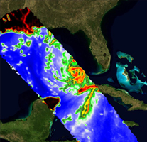
This image combines microwave emissions measurements from both COWVR and TEMPEST. White sections indicate the presence of clouds. Green portions indicate rain. Yellow, red, and black indicate where air and water vapor were moving most vigorously. Idalia's center is seen about 200 miles (322 kilometers) west of the Florida Keys, and rainfall is indicated on the western end of Cuba.
Figure A shows Idalia with solely COWVR data, collected at 34 GHz. About the size of a minifridge, COWVR measures natural microwave emissions over the ocean. The magnitude of the emissions increases with the amount of rain in the atmosphere, and the strongest rain produces the strongest microwave emissions.

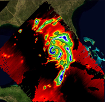
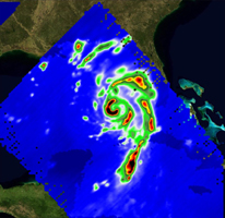
Figure AFigures B and C show the storm in data collected by TEMPEST at 89 and 165 GHz, respectively. Comparable in size to a cereal box, TEMPEST tracks microwaves at shorter wavelength than COWVR does, allowing it to see ice particles within the hurricane's cloudy regions that are thrust into the upper atmosphere by the storm.

Figure B

Figure C
Click on images for larger versionsCOWVR's development was funded by the U.S. Space Force, and TEMPEST was developed with NASA funding. The U.S. Space Test Program-Houston 8 (STP-H8) is responsible for hosting the instruments on the space station under Space Force funding in partnership with NASA.

