My
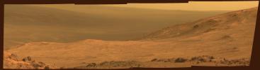
List |
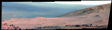
Catalog #
|
Target
|
Mission
|
Instrument
|
Addition Date
|
Size
|

|
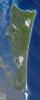
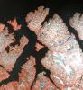
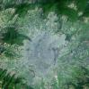
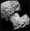
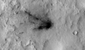
PIA17112 |
Earth |
Terra
|
ASTER
|
2013-06-25 |
1158x2904x3 |
|
- Title:
- North Stradbroke Island, Australia
|
|
|
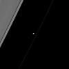
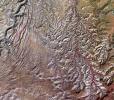
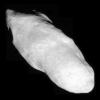
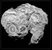
PIA17133 |
Prometheus |
Cassini-Huygens
|
ISS - Narrow Angle
|
2013-10-21 |
1015x1016x1 |
|
- Title:
- Two Shepherds
|
|
|
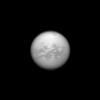
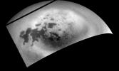
PIA17134 |
Titan |
Cassini-Huygens
|
ISS - Narrow Angle
|
2013-10-28 |
1003x1003x1 |
|
- Title:
- Senkyo Through the Clouds
|
|
|
PIA17140 |
Prometheus |
Cassini-Huygens
|
ISS - Narrow Angle
|
2013-12-09 |
1005x1005x1 |
|
- Title:
- Artists at Work
|
|
|
PIA17153 |
Prometheus |
Cassini-Huygens
|
ISS - Narrow Angle
|
2014-01-27 |
1016x1016x1 |
|
- Title:
- Pointing Toward Saturn
|
|
|
PIA17158 |
Prometheus |
Cassini-Huygens
|
ISS - Narrow Angle
|
2014-03-31 |
1020x1020x1 |
|
- Title:
- Prometheus' Handiwork
|
|
|
PIA17207 |
Prometheus |
Cassini-Huygens
|
ISS - Narrow Angle
|
2015-12-08 |
1020x1020x1 |
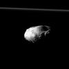
|
- Title:
- Prometheus Up Close
|
|
|
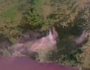
PIA17234 |
Earth |
Earth Observing-1 (EO-1)
|
Hyperion Hyperspectral Imager
|
2013-06-07 |
1200x1166x3 |
|
- Title:
- NASA's Earth Observing-1 Keeps Watchful Eye on South American Volcano Copahue
|
|
|
PIA17248 |
Earth |
CSIRO Parkes Observatory
|
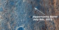
Parks Telescope
|
2013-07-08 |
3220x2225x3 |
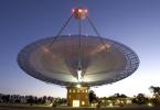
|
- Title:
- Parkes Telescope
|
|
|
PIA17263 |
Mars |
Mars Reconnaissance Orbiter (MRO)
|
MCS
|
2013-06-12 |
1883x2437x3 |
|
- Title:
- Scanning Martian Atmospheric Temperatures (Graphic)
|
|
|
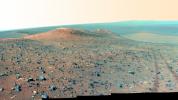
PIA17265 |
Mars |
Mars Exploration Rover (MER)
|
Panoramic Camera
|
2013-06-21 |
5274x1001x1 |
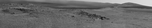
|
- Title:
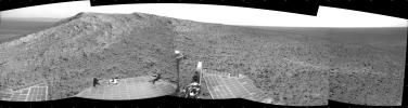
- 'Nobbys Head' on Opportunity's Southward Route
|
|
|
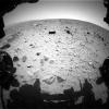
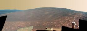
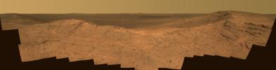
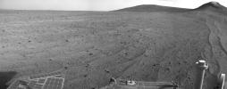
PIA17271 |
Mars |
Mars Exploration Rover (MER)
|
Hazcam
|
2013-07-02 |
1024x774x1 |
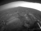
|
- Title:
- Opportunity's View in 'Botany Bay' Toward 'Solander Point'
|
|
|
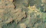
PIA17278 |
Mars |
Mars Exploration Rover (MER)
Mars Reconnaissance Orbiter (MRO)
|
HiRISE
|
2013-07-17 |
1616x839x3 |
|
- Title:
- Color View From Orbit Showing Opportunity in 'Botany Bay'
|
|
|
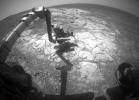
PIA17279 |
Mars |
Mars Science Laboratory (MSL)
|
Hazcam (MSL)
|
2013-07-17 |
4267x4267x1 |
|
- Title:
- One Down, Many Kilometers to Go
|
|
|
PIA17284 |
Earth |
Aqua
Terra
|
MODIS
MODIS
|
2013-06-13 |
1659x1452x3 |
|
- Title:
- Rates of Basal Melt of Antarctic Ice Shelves
|
|
|
PIA17305 |
Mars |
Mars Science Laboratory (MSL)
|
|
2013-08-27 |
1024x576x3 |
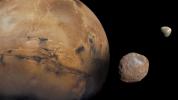
|
- Title:
- The Moons of Mars
|
|
|
PIA17312 |
Earth |
Terra
|
ASTER
|
2013-07-09 |
1578x1716x3 |
|
- Title:
- Kirkenes, Norway
|
|
|
PIA17355 |
Mars |
Mars Reconnaissance Orbiter (MRO)
Mars Science Laboratory (MSL)
|
HiRISE
|
2013-08-27 |
3300x2550x3 |
|
- Title:
- Curiosity's Progress on Route from 'Glenelg' to Mount Sharp
|
|
|
PIA17364 |
Mars |
Mars Exploration Rover (MER)
|
Panoramic Camera
|
2014-01-23 |
2940x3000x3 |
|
- Title:
- Mineral Detected from Orbit Found in Dark Veneers
|
|
|
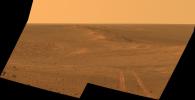
PIA17366 |
Mars |
Mars Exploration Rover (MER)
|
Navigation Camera
|
2013-10-23 |
4243x1135x1 |
|
- Title:
- Mars Hill-Climbing Opportunity at 'Solander Point'
|
|
|
PIA17383 |
Earth |
Terra
|
MISR
|
2013-07-20 |
904x755x3 |
|
- Title:
- NASA's MISR Instrument Captures View of Mountain Fire Near Idyllwild, Calif.
|
|
|
PIA17411 |
Earth |
Terra
|
ASTER
|
2013-08-16 |
2523x2922x3 |

|
- Title:
- Star Dunes, Algeria
|
|
|
PIA17413 |
Earth |
CloudSat
|
Cloud Profiling Radar (CPR)
MODIS
|
2013-08-22 |
1199x206x3 |
|
- Title:
- NASA's CloudSat Eyes Powerful Typhoon Utor
|
|
|
PIA17427 |
Earth |
Aqua
|
AIRS
|
2013-08-27 |
879x600x3 |

|
- Title:
- NASA's Aqua Spacecraft Images Pollution from California's Rim Fire
|
|
|
PIA17428 |
Earth |
Terra
|
MISR
|
2013-08-27 |
704x968x3 |
|
- Title:
- NASA's Terra Spacecraft Measures Height of California Rim Fire Smoke Plumes
|
|
|
PIA17429 |
Earth |
Terra
|
MISR
|
2013-08-27 |
1551x1258x3 |
|
- Title:
- NASA's Terra Spacecraft Eyes Smoke Plumes from Massive Rim Fire Near Yosemite
|
|
|
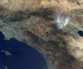
PIA17444 |
|
Spitzer Space Telescope
|
|
2013-09-24 |
4533x2550x3 |

|
- Title:
- Spitzer Trains Its Eyes on Exoplanets (Artist Concept)
|
|
|
PIA17446 |
|
Spitzer Space Telescope
|
Spitzer Space Telescope
|
2013-10-17 |
1024x683x3 |

|
- Title:
- Big Data on the Big Screen
|
|
|
PIA17449 |
|
Planck
|
Planck Telescope
|
2013-10-23 |
5645x3500x3 |

|
- Title:
- Planck and the Cosmic Microwave Background (Artist Concept)
|
|
|
PIA17454 |
Earth |
OSTM/Jason-2
|
Altimeter
|
2013-09-09 |
1100x960x3 |

|
- Title:
- 'La Nada' Climate Pattern Lingers in the Pacific
|
|
|
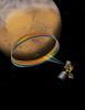
PIA17466 |
Vesta |
Dawn
Hubble Space Telescope
|
Framing Camera
Hubble Space Telescope
|
2013-09-27 |
683x807x3 |
|
- Title:
- Comparing Vesta's Topography
|
|
|
PIA17478 |
Vesta |
Dawn
|
Framing Camera
|
2013-11-06 |
1648x728x1 |
|
- Title:
- Bellicia Crater, in Visible Light
|
|
|
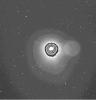
PIA17483 |
ISON |
Hubble Space Telescope
|
|
2013-07-02 |
1008x935x3 |
|
- Title:
- Comet ISON Brings Holiday Fireworks

|
|
|
PIA17504 |
Earth |
Terra
|
ASTER
|
2013-09-24 |
2003x3287x3 |
|
- Title:
- NASA Spacecraft Images Destructive Argentine Wildfire
|
|
|
PIA17513 |
Earth |
Terra
|
ASTER
|
2013-09-26 |
1460x1470x3 |
|
- Title:
- Kathmandu, Nepal
|
|
|
PIA17539 |
Earth |
Terra
|
ASTER
|
2013-10-17 |
1866x1632x3 |
|
- Title:
- Canyonlands National Park, Utah
|
|
|
PIA17577 |
Earth |
Terra
|
MISR
|
2013-10-24 |
1013x795x3 |
|
- Title:
- MISR Stereo Imagery of Blue Mountain Fires in New South Wales, Australia
|
|
|
PIA17583 |
Mars |
Mars Exploration Rover (MER)
|
Panoramic Camera
|
2013-11-13 |
9908x3546x3 |
|
- Title:
- 'Murray Ridge' on Rim of Endeavour Crater on Mars, False Color
|
|
|
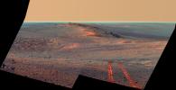
PIA17585 |
Mars |
Mars Exploration Rover (MER)
|
Navigation Camera
|
2013-11-13 |
4253x1820x1 |
|
- Title:
- Opportunity's View Climbing 'Murray Ridge'
|
|
|
PIA17586 |
Mars |
Mars Exploration Rover (MER)
Mars Reconnaissance Orbiter (MRO)
|
HiRISE
|
2013-11-13 |
8192x4298x3 |
|
- Title:
- A New Perspective on Murray Ridge
|
|
|
PIA17588 |
Mars |
Mars Exploration Rover (MER)
|
Navigation Camera
|
2013-11-13 |
3985x1776x3 |
|
- Title:
- 'Murray Ridge' in Stereo from Mars Rover Opportunity
|
|
|
PIA17589 |
Mars |
Mars Exploration Rover (MER)
Mars Reconnaissance Orbiter (MRO)
|
CTX
|
2013-12-03 |
4731x3605x3 |
|
- Title:
- Opportunity's Journey, Approaching 10th Anniversary
|
|
|
PIA17590 |
Mars |
Mars Exploration Rover (MER)
|
Navigation Camera
|
2013-12-03 |
1024x1024x1 |
|
- Title:
- Tracks of a Climb on Opportunity's Sol 3485
|
|
|
PIA17596 |
Mars |
Mars Reconnaissance Orbiter (MRO)
Mars Science Laboratory (MSL)
|
CTX
|
2013-12-09 |
3300x2550x3 |
|
- Title:
- Possible Extent of Ancient Lake in Gale Crater, Mars
|
|
|
PIA17661 |
Vesta |
Dawn
|
Framing Camera
|
2013-12-16 |
1437x863x3 |
|
- Title:
- Flowing in, Flowing out of Aelia
|
|
|
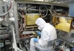
PIA17665 |
|
Rosetta
|
|
2014-01-24 |
718x476x3 |
|
- Title:
- Electronics for a Spectrometer
|
|
|
PIA17676 |
Mercury |
MESSENGER
|
MDIS - Narrow Angle
|
2013-11-08 |
1020x1024x1 |
|
- Title:
- Ride Along with MESSENGER: Movie 2
|
|
|
PIA17680 |
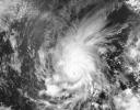
Earth |
Aqua
OSCAT
|
AIRS
OSCAT
|
2013-11-08 |
1200x600x3 |
|
- Title:
- Super Typhoon Haiyan
|
|
|
PIA17756 |
Mars |
Mars Exploration Rover (MER)
|
Panoramic Camera
|
2014-01-23 |
1035x651x3 |
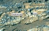
|
- Title:
- 'Esperance6' and 'Lihir' Rover Targets
|
|
|
PIA17758 |
Mars |
Mars Exploration Rover (MER)
Mars Reconnaissance Orbiter (MRO)
|
CTX
|
2014-01-23 |
4853x3687x3 |
|
- Title:
- Opportunity's First Decade of Driving on Mars
|
|
|
PIA17759 |
Mars |
Mars Exploration Rover (MER)
|
Panoramic Camera
|
2014-01-23 |
3408x2772x3 |
|
- Title:
- Self-Portrait by Opportunity Mars Rover in January 2014
|
|
|
PIA17761 |
Mars |
Mars Exploration Rover (MER)
|
Panoramic Camera
|
2014-01-21 |
1171x720x3 |
|
- Title:
- Rock That Appeared in Front of Opportunity on "Murray Ridge"
|
|
|
PIA17771 |
Earth |
Airborne Snow Observatory
|
|
2013-05-02 |
4000x3000x3 |
|
- Title:
- Tuolumne River Basin seen by NASA's Airborne Snow Observatory
|
|
|
PIA17772 |
Earth |
Airborne Snow Observatory
|
|
2013-05-02 |
910x1178x3 |
|
- Title:
- Snow Depth Depicted on Mt. Lyell by NASA's Airborne Snow Observatory
|
|
|
PIA17796 |
Comet |
Rosetta
|
OSIRIS
|
2014-03-27 |
2048x1966x3 |
|
- Title:
- Rosetta Images its Target
|
|
|
PIA17800 |
|
OCO-2
|
OCO-2
|
2008-12-09 |
8192x8192x3 |

|
- Title:
- OCO-2 in Space
|
|
|
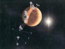
PIA17896 |
Earth |
OCO-2
|
OCO-2
|
2014-01-22 |
2560x1440x3 |

|
- Title:
- NASA's Orbiting Carbon Observatory (OCO-2) (Artist Concept)
|
|
|
PIA17898 |
|
SMAP
|
|
2014-01-22 |
8196x8196x3 |
|
- Title:
- NASA's Soil Moisture Active Passive (SMAP) (Artist Concept)
|
|
|
PIA17941 |
Mars |
Mars Exploration Rover (MER)
Mars Reconnaissance Orbiter (MRO)
|
HiRISE
|
2014-02-19 |
1416x1441x3 |
|
- Title:
- Opportunity Rover on 'Murray Ridge' Seen From Orbit
|
|
|
PIA17942 |
Mars |
Mars Exploration Rover (MER)
|
Panoramic Camera
|
2014-02-14 |
1020x1020x3 |
|
- Title:
- Where Martian 'Jelly Doughnut' Rock Came From
|
|
|
PIA17943 |
Mars |
Mars Exploration Rover (MER)
|
Panoramic Camera
|
2014-02-14 |
4383x934x3 |

|
- Title:
- Opportunity's Southward View of 'McClure-Beverlin Escarpment' on Mars
|
|
|
PIA17956 |
Mars |
Mars Exploration Rover (MER)
|
Hazcam
|
2014-03-27 |
1024x1024x1 |
|
- Title:
- Shadow Portrait of NASA Rover Opportunity on Martian Slope
|
|
|
PIA18032 |
Comet |
NEOWISE
|
NEOWISE Telescope
|
2014-02-27 |
1148x1148x3 |
|
- Title:
- An Infrared portrait of Comet NEOWISE (C/2014 C3)
|
|
|
PIA18042 |
|
OCO-2
|
OCO-2
|
2014-04-15 |
1993x3000x3 |
|
- Title:
- Lifting of NASA's OCO-2's Delta II Launch Vehicle
|
|
|
PIA18043 |
|
OCO-2
|
OCO-2
|
2014-04-15 |
1993x3000x3 |
|
- Title:
- Lifting NASA's OCO-2's Delta II Launch Vehicle Second Stage into Position for Mating
|
|
|
PIA18044 |
|
OCO-2
|
OCO-2
|
2014-04-15 |
1993x3000x3 |
|
- Title:
- Positioning NASA's OCO-2's Delta II Launch Vehicle Second Stage for Mating
|
|
|
PIA18045 |
|
OCO-2
|
OCO-2
|
2014-04-15 |
1993x3000x3 |
|
- Title:
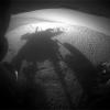
- Mating NASA's OCO-2's Delta II Launch Vehicle First and Second Stages
|
|
|
PIA18047 |
Earth |
Aqua
|
AIRS
|
2014-04-29 |
900x695x3 |
|
- Title:
- NASA Satellite Spots Severe Weather Outbreak in South
|
|
|
PIA18079 |
Mars |
Mars Exploration Rover (MER)
|
Panoramic Camera
|
2014-04-17 |
7694x6016x3 |
|
- Title:
- Self-Portrait by Freshly Cleaned Opportunity Mars Rover in March 2014
|
|
|
PIA18080 |
Mars |
Mars Exploration Rover (MER)
|
Panoramic Camera
|
2014-04-17 |
7694x6016x3 |
|
- Title:
- Self-Portrait by Freshly Cleaned Opportunity Mars Rover, False Color
|
|
|
PIA18094 |
Mars |
Mars Exploration Rover (MER)
|
Panoramic Camera
|
2014-05-19 |
5454x1264x3 |

|
- Title:
- Endeavour Crater Rim From 'Murray Ridge' on Mars, False Color
|
|
|
PIA18097 |
Earth |
Aqua
|
MODIS
|
2014-05-29 |
7091x5556x1 |
|
- Title:
- Hurricane Amanda
|
|
|
PIA18156 |
|
Aqua
|
|
2002-05-08 |
1280x720x3 |

|
- Title:
- Aqua Satellite Orbiting Earth (Artist's Concept)
|
|
|
PIA18157 |
|
ACRIMSAT
|
|
1999-12-21 |
800x688x3 |

|
- Title:
- Active Cavity Irradiance Monitor Satellite (ACRIMSAT) Artist's Concept
|
|
|
PIA18159 |
|
Clementine
|
|
1994-01-25 |
1024x768x3 |

|
- Title:
- Clementine Fully Deployed (Artist's Concept)
|
|
|
PIA18162 |
|
Lunar Prospector
|
|
1998-01-08 |
2000x1594x3 |

|
- Title:
- Lunar Prospector (Artist's Concept)
|
|
|
PIA18169 |
|
SDO
|
|
2010-02-11 |
1280x720x3 |
|
- Title:
- Solar Dynamics Observatory (Artist's Concept)
|
|
|
PIA18172 |
|
Solar TErrestrial RElations Observatory (STEREO)
|
|
2011-06-01 |
1280x720x3 |

|
- Title:
- Solar Terrestrial Relations Observatory Spacecraft (Artist's Concept)
|
|
|
PIA18175 |
|
Magellan
|
|
1990-08-10 |
818x615x3 |
|
- Title:
- Magellan Orbit (Artist's Concept)
|
|
|
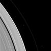
PIA18186 |
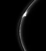
Prometheus |
Cassini-Huygens
|
ISS - Narrow Angle
|
2010-02-19 |
700x700x1 |
|
- Title:
- Prometheus Popping
|
|
|
PIA18211 |
Earth |
Earth Observing-1 (EO-1)
|
Advanced Land Imager (ALI)
|
2014-09-15 |
1158x879x3 |
|
- Title:
- Hawaii Lava Threat Closely Monitored by NASA EO-1 Spacecraft
|
|
|
PIA18270 |
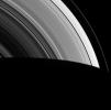
Prometheus |
Cassini-Huygens
|
ISS - Narrow Angle
|
2014-06-09 |
1018x1018x1 |

|
- Title:
- Gored of the Rings
|
|
|
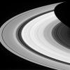
PIA18272 |
Prometheus |
Cassini-Huygens
|
ISS - Wide Angle
|
2014-07-14 |
983x975x1 |
|
- Title:
- A Dot Does a Lot
|
|
|
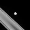
PIA18283 |
Tethys |
Cassini-Huygens
|
ISS - Narrow Angle
|
2014-09-22 |
1024x1024x1 |
|
- Title:
- The Odd Trio
|
|
|
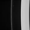
PIA18306 |
S Rings |
Cassini-Huygens
|
ISS - Narrow Angle
|
2015-03-23 |
1024x1024x1 |
|
- Title:
- Moon Convention
|
|
|
PIA18308 |
S Rings |
Cassini-Huygens
|
ISS - Wide Angle
|
2015-03-16 |
1024x1024x1 |
|
- Title:
- Groovy
|
|
|
PIA18324 |
Prometheus |
Cassini-Huygens
|
ISS - Narrow Angle
|
2015-07-06 |
958x1020x1 |
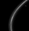
|
- Title:
- Ring Slicer
|
|
|
PIA18334 |
S Rings |
Cassini-Huygens
|
ISS - Narrow Angle
|
2015-09-21 |
1023x587x1 |
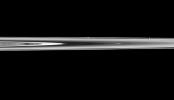
|
- Title:
- Moons In Hiding
|
|
|
PIA18337 |
S Rings |
Cassini-Huygens
|
ISS - Narrow Angle
|
2015-10-19 |
928x1020x1 |
|
- Title:
- Gored Clump in Saturn's F Ring
|
|
|
PIA18374 |
|
OCO-2
|
OCO-2
|
2014-05-15 |
10666x6000x3 |

|
- Title:
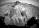
- NASA's Orbiting Carbon Observatory (OCO)-2 (Artist Concept)
|
|
|
PIA18375 |
|
OCO-2
|
OCO-2
|
2014-05-15 |
8192x8192x3 |

|
- Title:
- NASA's Orbiting Carbon Observatory (OCO)-2 (Artist Concept)
|
|
|
PIA18393 |
Mars |
Mars Exploration Rover (MER)
|
Panoramic Camera
|
2014-06-23 |
7843x2000x3 |
|
- Title:
- 'Pillinger Point' Overlooking Endeavour Crater on Mars
|
|
|
PIA18394 |
Mars |
Mars Exploration Rover (MER)
|
Panoramic Camera
|
2014-06-23 |
7843x2000x3 |
|
- Title:
- 'Pillinger Point' Overlooking Endeavour Crater on Mars (False Color)
|
|
|
PIA18404 |
Mars |
Mars Exploration Rover (MER)
Mars Reconnaissance Orbiter (MRO)
|
CTX
|
2014-07-28 |
2420x1838x3 |
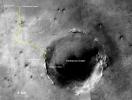
|
- Title:
- Opportunity's Journey Exceeds 25 Miles
|
|
|
PIA18414 |
Mars |
Mars Exploration Rover (MER)
|
Panoramic Camera
|
2014-07-28 |
3609x3130x3 |
|
- Title:
- 'Lunokhod 2 Crater' on Mars (False Color)
|
|
|
PIA18416 |
Mars |
Mars Exploration Rover (MER)
|
Panoramic Camera
|
2014-07-28 |
3609x3130x3 |
|
- Title:
- 'Lunokhod 2' Crater on Mars
|
|
|
PIA18421 |
Titan |
Cassini-Huygens
|
Imaging Science Subsystem
|
2014-08-12 |
1307x784x1 |
|
- Title:
- Northern Clouds Return to Titan
|
|
|
PIA18422 |
Comet |
Rosetta
|
OSIRIS
|
2014-07-31 |
423x442x1 |
|
- Title:
- Rosetta's Comet: Imaging the Coma
|
|
|
PIA18430 |
Titan |
Cassini-Huygens
|
Radar Mapper
|
2014-09-29 |
2000x658x1 |
|
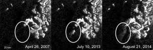
- Title:
- Mysterious Changing Feature in Ligeia Mare
|
|
|
PIA18435 |
Enceladus |
Cassini-Huygens
|
Imaging Science Subsystem
|
2014-11-04 |
15960x7980x3 |
|
- Title:
- Color Maps of Enceladus - 2014
|
|
|
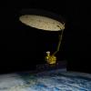
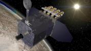
PIA18457 |
Earth |
OCO-2
|
OCO-2
|
2014-06-30 |
4928x3280x3 |
|
- Title:
- Orbiting Carbon Observatory-2 Ready to Blast Off
|
|
|
PIA18458 |
Earth |
OCO-2
|
OCO-2
|
2014-06-30 |
2232x1643x3 |
|
- Title:
- Key Events in the Launch of NASA's Orbiting Carbon Observatory-2
|
|
|
PIA18478 |
Mars |
Mars Science Laboratory (MSL)
|
Mastcam
|
2014-09-11 |
1319x1187x3 |
|
- Title:
- Loose Rock Leads to Incomplete Drilling
|
|
|
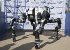
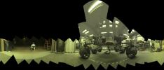
PIA18567 |
Earth |
|
RoboSimian
|
2014-07-16 |
1500x956x3 |

|
- Title:
- RoboSimian's Inner Workings
|
|
|
PIA18591 |
Mars |
Mars Exploration Rover (MER)
|
Panoramic Camera
|
2014-10-20 |
1020x1024x1 |
|
- Title:
- Mars Rover Opportunity's View of Passing Comet
|
|
|
PIA18592 |
Mars |
Mars Exploration Rover (MER)
|
Panoramic Camera
|
2014-10-20 |
1020x1024x1 |
|
- Title:
- Mars Rover Opportunity's View of Passing Comet (Short Exposure)
|
|
|
PIA18595 |
Mars |
Mars Exploration Rover (MER)
|
Navigation Camera
|
2014-08-14 |
7688x1962x1 |
|
- Title:
- Opportunity's Surroundings After 25 Miles on Mars
|
|
|
PIA18598 |
Mars |
Mars Exploration Rover (MER)
|
Navigation Camera
|
2014-08-29 |
2246x884x1 |
|
- Title:
- Opportunity's Rear-Facing View Ahead After a Drive
|
|
|
PIA18604 |
Mars |
Mars Exploration Rover (MER)
|
Panoramic Camera
|
2014-09-09 |
2285x1168x3 |
|
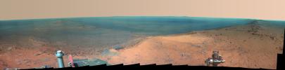
- Title:
- Rover Tracks in Northward View Along West Rim of Endeavour
|
|
|
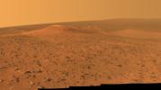
PIA18605 |
Mars |
Mars Exploration Rover (MER)
|
Panoramic Camera
|
2014-09-09 |
2285x1168x3 |
|
- Title:
- Rover Tracks in Northward View Along West Rim of Endeavour, False Color
|
|
|
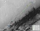
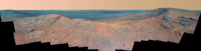
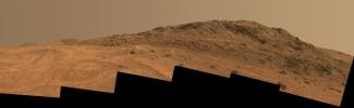
PIA18614 |
Mars |
Mars Exploration Rover (MER)
|
Panoramic Camera
|
2014-10-16 |
4457x2488x3 |
|
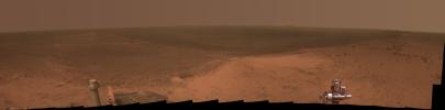
- Title:
- Opportunity's Northward View of 'Wdowiak Ridge'
|
|
|
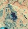
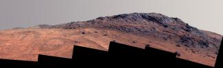
PIA18615 |
Mars |
Mars Exploration Rover (MER)
|
Panoramic Camera
|
2014-10-16 |
4461x2498x3 |
|
- Title:
- Opportunity's Northward View of 'Wdowiak Ridge' (False Color)
|
|
|
PIA18778 |
Comet |
Rosetta
|
OSIRIS
|
2014-08-25 |
1954x1896x1 |
|
- Title:
- Four Rosetta Candidate Landing Sites
|
|
|
PIA18779 |
Comet |
Rosetta
|
OSIRIS
|
2014-08-25 |
1893x1904x1 |
|
- Title:
- Two Large-Lobe Landing Sites for Rosetta
|
|
|
PIA18795 |
Earth |
Aqua
|
MODIS
|
2014-09-02 |
6843x3890x3 |
|
- Title:
- 2013 Yosemite Fire Assessed by NASA Satellite Data
|
|
|
PIA18799 |
Earth |
Earth Observing-1 (EO-1)
|
Advanced Land Imager (ALI)
Hyperion Hyperspectral Imager
|
2014-09-03 |
2800x4000x3 |
|
- Title:
- Iceland Volcanic Eruption Monitored by NASA EO-1 Spacecraft
|
|
|
PIA18826 |
Comet |
Rosetta
|
CIVA
|
2014-10-14 |
1024x1024x1 |
|
- Title:
- Rosetta Selflessly Offers Beautiful Comet Selfie
|
|
|
PIA18828 |
|
SMAP
|
|
2014-10-15 |
5396x3807x3 |
|
- Title:
- NASA's Soil Moisture Active Passive (SMAP) Lowered into Place
|
|
|
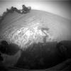
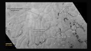
PIA18859 |
Mars |
Mars Express (MEX)
|
Mars Advanced Radar for Subsurface and Ionosphere Sounding (MARSIS)
|
2014-11-07 |
2373x2138x3 |
|
- Title:
- Radar-Detected Change in Martian Near-Polar Ionosphere After Comet's Flyby
|
|
|
PIA18860 |
Mars |
Mars Express (MEX)
|
Mars Advanced Radar for Subsurface and Ionosphere Sounding (MARSIS)
|
2014-11-07 |
2373x2138x3 |
|
- Title:
- Change in Mars' Mid-Latitude Ionosphere After Comet Flyby
|
|
|
PIA18862 |
Mars |
Mars Reconnaissance Orbiter (MRO)
|
HiRISE
|
2014-11-07 |
973x779x3 |
|
- Title:
- Brightness Rhythm of Mars Flyby Comet Is Clue to Rotation Rate
|
|
|
PIA18870 |
Comet |
Rosetta
|
CIVA
|
2014-11-12 |
1024x1024x1 |
|
- Title:
- Farewell Shot of Rosetta by Philae Lander
|
|
|
PIA18872 |
Comet |
Rosetta
|
CIVA
|
2014-11-11 |
1024x1024x1 |
|
- Title:
- Rosetta Mission Selfie at 30 Miles
|
|
|
PIA18879 |
Comet |
Rosetta
|
CIVA
|
2014-11-13 |
1451x1772x1 |
|
- Title:
- First Panoramic View from Comet Lander
|
|
|
PIA18885 |
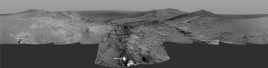
Mars |
Mars Exploration Rover (MER)
|
Microscopic Imager
|
2014-11-18 |
1760x1069x1 |
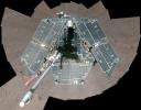
|
- Title:
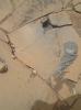
- Clues to Wet History in Texture of a Martian Rock
|
|
|
PIA18908 |
|
Spitzer Space Telescope
|
IRAC
|
2015-01-27 |
3000x1688x3 |
|
- Title:
- Finding 'Yellowballs' in our Milky Way
|
|
|
PIA18918 |
|
NuSTAR
XMM-Newton
|
|
2015-02-19 |
3000x2400x3 |
|
- Title:
- The Answer is Blowing in the Black Hole Wind
|
|
|
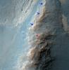
PIA19037 |
Mars |
Mars Science Laboratory (MSL)
|
Mastcam
|
2014-11-04 |
768x768x3 |
|
- Title:
- 'Confidence Hills' Drill Powder in Scoop
|
|
|
PIA19040 |
Comet |
Rosetta
|
OSIRIS
|
2014-11-06 |
2048x2048x1 |

|
- Title:
- Dark Side of Comet 67P/Churyumov-Gerasimenko
|
|
|
PIA19047 |
Titan |
Cassini-Huygens
|
Radar Mapper
|
2014-11-10 |
1500x728x1 |
|
- Title:
- Bright Feature Appears in Titan's Kraken Mare
|
|
|
PIA19054 |
Titan |
Cassini-Huygens
|
Radar Mapper
|
2015-02-12 |
1407x843x1 |
|
- Title:
- Leilah Fluctus Despeckled
|
|
|
PIA19066 |
Mars |
Mars Science Laboratory (MSL)
|
Mastcam
|
2014-11-25 |
4188x2799x3 |
|
- Title:
- Within Rover's Reach at Mars Target Area 'Alexander Hills'
|
|
|
PIA19067 |
Mars |
Mars Reconnaissance Orbiter (MRO)
Mars Science Laboratory (MSL)
|
HiRISE
|
2014-12-08 |
3300x2550x3 |
|
- Title:
- Curiosity Mars Rover's Route from Landing to Base of Mount Sharp
|
|
|
PIA19068 |
Mars |
Mars Science Laboratory (MSL)
|
Mastcam
|
2014-12-08 |
3619x2196x3 |
|
- Title:
- Inclined Martian Sandstone Beds Near 'Kimberley'
|
|
|
PIA19069 |
Mars |
Mars Science Laboratory (MSL)
|
Mastcam
|
2014-12-08 |
4657x1024x3 |
|
- Title:
- Bedding Pattern Interpreted as Martian Delta Deposition
|
|
|
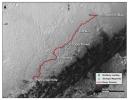
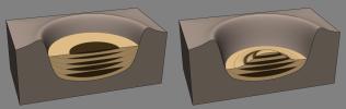
PIA19071 |
Mars |
Mars Science Laboratory (MSL)
|
|
2014-12-08 |
1931x1078x3 |
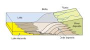
|
- Title:
- How a Delta Forms Where River Meets Lake
|
|
|
PIA19072 |
Mars |
Mars Science Laboratory (MSL)
|
Mastcam
|
2014-12-08 |
2440x1049x3 |
|
- Title:
- Sol 696 (July 22, 2014), Left
|
|
|
PIA19073 |
|
Mars Science Laboratory (MSL)
|
|
2014-12-08 |
1391x467x3 |
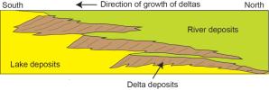
|
- Title:
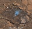
- Multiple Deltas Built Out Over Time
|
|
|
PIA19074 |
Mars |
Mars Science Laboratory (MSL)
|
Mastcam
|
2014-12-08 |
1588x1160x3 |
|
- Title:
- Sedimentary Signs of a Martian Lakebed
|
|
|
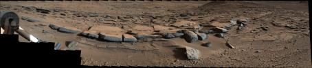
PIA19075 |
Mars |
Mars Science Laboratory (MSL)
|
Mastcam
|
2014-12-08 |
2011x1198x3 |

|
- Title:
- Thin-Laminated Rock in 'Pahrump Hills' Outcrop
|
|
|
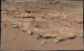
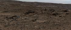
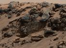
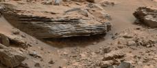
PIA19079 |
Mars |
Mars Science Laboratory (MSL)
|
|
2014-12-08 |
4030x1275x3 |
|
- Title:
- Sedimentation and Erosion in Gale Crater, Mars
|
|
|
PIA19081 |
Mars |
Mars Science Laboratory (MSL)
|
Mastcam
|
2014-12-08 |
2350x1026x3 |
|
- Title:
- Martian Rock's Evidence of Lake Currents
|
|
|
PIA19082 |
Mars |
Mars Exploration Rover (MER)
|
Hazcam
|
2014-12-11 |
1024x1024x1 |
|
- Title:
- Opportunity Pausing at a Bright Outcrop on Endeavour Rim, Sol 3854
|
|
|
PIA19090 |
Mars |
Mars Science Laboratory (MSL)
|
SAM
|
2014-12-16 |
960x720x3 |
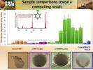
|
- Title:
- Comparing 'Cumberland' With Other Samples Analyzed by Curiosity
|
|
|
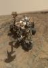
PIA19098 |
Mars |
Mars Exploration Rover (MER)
|
Navigation Camera
|
2015-01-08 |
2586x1007x1 |
|
- Title:
- Opportunity's View from Atop 'Cape Tribulation'
|
|
|
PIA19099 |
Mars |
Mars Exploration Rover (MER)
|
Navigation Camera
|
2015-01-08 |
4102x1091x1 |
|
- Title:
- Opportunity's Approach to 'Cape Tribulation' Summit
|
|
|
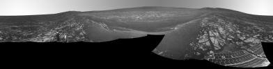
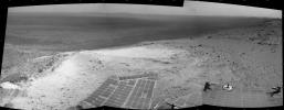
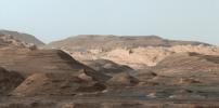
PIA19105 |
Mars |
Mars Science Laboratory (MSL)
|
MAHLI
|
2015-01-14 |
1196x1607x3 |
|
- Title:
- Results from Curiosity's Mini-Drill Test at 'Mojave'
|
|
|
PIA19109 |
Mars |
Mars Exploration Rover (MER)
|
Panoramic Camera
|
2015-01-22 |
8097x2000x3 |
|
- Title:
- High Viewpoint for 11-Year-Old Rover Mission on Mars
|
|
|
PIA19110 |
Mars |
Mars Exploration Rover (MER)
|
Panoramic Camera
|
2015-01-22 |
8108x2000x3 |
|
- Title:
- High Martian Viewpoint for 11-Year-Old Rover (False-Color Landscape)
|
|
|
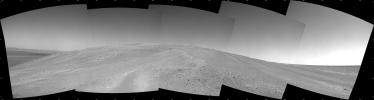
PIA19112 |
Mars |
Mars Exploration Rover (MER)
|
Navigation Camera
|
2015-01-27 |
3924x2052x3 |
|
- Title:
- Lander Trench Dug by Opportunity
|
|
|
PIA19113 |
Mars |
Mars Exploration Rover (MER)
|
Microscopic Imager
|
2015-01-27 |
1077x1077x3 |
|
- Title:
- Martian Concretions Near Fram Crater
|
|
|
PIA19141 |
Mars |
Mars Exploration Rover (MER)
|
HiRISE
|
2015-02-10 |
3602x2208x3 |
|
- Title:
- Opportunity Rover Nears Mars Marathon Feat
|
|
|
PIA19145 |
Mars |
Mars Science Laboratory (MSL)
|
Mastcam
|
2015-03-06 |
1278x1092x3 |
|
- Title:
- Curiosity's Drill After Drilling at 'Telegraph Peak'
|
|
|
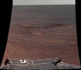
PIA19146 |
Mars |
Mars Exploration Rover (MER)
|
Hazcam
|
2015-03-05 |
1024x742x1 |
|
- Title:
- Blocky Rock is Exam Target for Mars Rover Opportunity
|
|
|
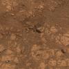
PIA19148 |
Mars |
Mars Science Laboratory (MSL)
|
HiRISE
|
2015-03-12 |
1138x711x3 |
|
- Title:
- Curiosity Heading Away from 'Pahrump Hills'
|
|
|
PIA19149 |
Earth |
Mars Science Laboratory (MSL)
|
SAM
|
2015-03-31 |
1019x702x3 |
|
- Title:
- Preparation for Analytical Measurements on Mars
|
|
|
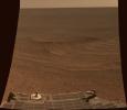
PIA19151 |
Mars |
Mars Exploration Rover (MER)
|
Panoramic Camera
|
2015-03-23 |
3687x1006x3 |
|
- Title:
- Mars 'Marathon Valley' Overlook
|
|
|
PIA19152 |
Mars |
Mars Exploration Rover (MER)
|
Panoramic Camera
|
2015-03-23 |
3687x1006x3 |
|
- Title:
- Mars 'Marathon Valley' Overlook (False Color)
|
|
|
PIA19154 |
Mars |
Mars Exploration Rover (MER)
|
CTX
|
2015-03-24 |
3360x2537x3 |
|
- Title:
- Opportunity Rover's Full Marathon-Length Traverse
|
|
|
PIA19155 |
Mars |
Mars Exploration Rover (MER)
|
Navigation Camera
|
2015-03-24 |
7719x1982x1 |
|
- Title:
- Opportunity's Approach to 'Marathon Valley'
|
|
|
PIA19157 |
Mars |
Mars Exploration Rover (MER)
Mars Reconnaissance Orbiter (MRO)
|
HiRISE
|
2015-03-24 |
3602x2208x3 |
|
- Title:
- Opportunity Rover Surpasses Marathon Distance
|
|
|
PIA19158 |
Mars |
Mars Exploration Rover (MER)
|
|
2015-03-24 |
3200x1400x3 |

|
- Title:
- Opportunity's Marathon Journey
|
|
|
PIA19159 |
Mars |
Mars Reconnaissance Orbiter (MRO)
Mars Science Laboratory (MSL)
|
HiRISE
|
2015-03-27 |
2072x1225x1 |
|
- Title:
- Changes in Scars From 2012 Mars Landing
|
|
|
PIA19160 |
Mars |
Mars Exploration Rover (MER)
|
Hazcam
|
2015-03-27 |
1024x736x1 |
|
- Title:
- Mars Rover Opportunity Examines Bright 'Athens'
|
|
|
PIA19328 |
Earth |
|
RoboSimian
|
2015-06-09 |
6681x4772x3 |
|
- Title:
- RoboSimian at DARPA Robotics Challenge
|
|
|
PIA19332 |
|
Spitzer Space Telescope
|
|
2015-04-14 |
3840x2160x3 |
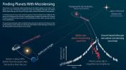
|
- Title:
- Infographic: Finding Planets With Microlensing
|
|
|
PIA19333 |
|
Spitzer Space Telescope
|
|
2015-04-14 |
3556x2000x3 |
|
- Title:
- Map of Exoplanets Found in Our Galaxy (Artist's Concept)
|
|
|
PIA19335 |
|
NuSTAR
|
NuSTAR
|
2015-05-07 |
3000x1679x3 |

|
- Title:
- Tracing Titanium's Escape
|
|
|
PIA19354 |
|
NEOWISE
|
|
2015-03-26 |
1799x1799x3 |

|
- Title:
- NEOWISE Wise to Comet Lovejoy
|
|
|
PIA19387 |
Mars |
Mars Science Laboratory (MSL)
|
Navcam (MSL)
|
2015-04-13 |
3368x832x3 |
|
- Title:
- Scene From 'Artist's Drive' on Mars (Stereo)
|
|
|
PIA19393 |
Mars |
Mars Exploration Rover (MER)
|
Panoramic Camera
|
2015-04-30 |
6322x2492x3 |
|
- Title:
- Rock Spire in 'Spirit of St. Louis Crater' on Mars
|
|
|
PIA19394 |
Mars |
Mars Exploration Rover (MER)
|
Panoramic Camera
|
2015-04-30 |
6322x2492x3 |
|
- Title:
- Rock Spire in 'Spirit of St. Louis Crater' on Mars (False Color)
|
|
|
PIA19395 |
Mars |
Mars Exploration Rover (MER)
|
Panoramic Camera
|
2015-04-30 |
6176x2492x3 |
|
- Title:
- Rock Spire in 'Spirit of St. Louis Crater' on Mars (Stereo)
|
|
|
PIA19401 |
Mars |
Mars Science Laboratory (MSL)
|
Mastcam
|
2015-05-08 |
1619x1154x3 |
|
- Title:
- Sunset Sequence in Mars' Gale Crater (Animation)
|
|
|
PIA19420 |
Mercury |
MESSENGER
|
MLA
|
2015-04-16 |
3750x3752x3 |
|
- Title:
- The Ups and Downs of Mercury's Topography
|
|
|
PIA19676 |
Mars |
Mars Science Laboratory (MSL)
|
Mastcam
|
2015-07-01 |
3946x2455x3 |
|
- Title:
- Geological Contact Zone Near 'Marias Pass' on Mars
|
|
|
PIA19677 |
Mars |
Mars Science Laboratory (MSL)
|
MAHLI
|
2015-07-01 |
1584x1184x3 |
|
- Title:
- Diverse Grains in Mars Sandstone Target 'Big Arm'
|
|
|
PIA19686 |
Pluto |
New Horizons
|
LORRI
|
2015-06-11 |
1024x768x3 |
|
- Title:
- Faces of Pluto
|
|
|
PIA19691 |
Pluto |
New Horizons
|
LORRI
|
2015-06-22 |
1024x768x3 |
|
- Title:
- Features on the Close Approach Hemisphere
|
|
|
PIA19700 |
Pluto |
New Horizons
|
LORRI
|
2015-07-07 |
985x493x3 |
|
- Title:
- The Whale and the Donut
|
|
|
PIA19709 |
Charon |
New Horizons
|
LORRI
|
2015-07-15 |
1050x794x3 |
|
- Title:
- Charon's Surprising Youthful and Varied Terrain
|
|
|
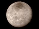
PIA19711 |
Hydra |
New Horizons
|
LORRI
|
2015-07-15 |
1050x704x1 |
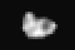
|
- Title:
- Hydra Emerges from the Shadows
|
|
|
PIA19714 |
Pluto |
New Horizons
|
LORRI
|
2015-07-17 |
1280x720x3 |
|
- Title:
- Portion of Pluto's Sputnik Planum (Sputnik Plain)
|
|
|
PIA19810 |
Mars |
Mars Science Laboratory (MSL)
|
MAHLI
|
2015-08-19 |
4320x1845x3 |
|
- Title:
- Test Rover at JPL During Preparation for Mars Rover's Low-Angle Selfie
|
|
|
PIA19819 |
Mars |
Mars Exploration Rover (MER)
|
Panoramic Camera
|
2015-09-25 |
5725x1758x3 |
|
- Title:
- 'Hinners Point' Above Floor of 'Marathon Valley' on Mars
|
|
|
PIA19820 |
Mars |
Mars Exploration Rover (MER)
|
Panoramic Camera
|
2015-09-25 |
5725x1758x3 |
|
- Title:
- 'Hinners Point' Above Floor of 'Marathon Valley' on Mars (Enhanced Color)
|
|
|
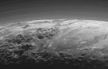
PIA19841 |
Pluto |
New Horizons
|
LORRI
|
2015-07-17 |
1280x720x3 |
|
- Title:
- Frozen Plains in the Heart of Pluto's 'Heart'
|
|
|
PIA19857 |
Pluto |
New Horizons
|
LORRI
|
2015-07-25 |
1920x1080x3 |

|
- Title:
- Pluto in True Color
|
|
|
PIA19866 |
Charon |
New Horizons
|
LORRI
|
2015-07-30 |
9520x4760x1 |
|
- Title:
- Global Map of Pluto's Moon Charon
|
|
|
PIA19872 |
|
Spitzer Space Telescope
|
Spitzer Space Telescope
|
2015-08-20 |
4800x2700x3 |

|
- Title:
- NASA's Spitzer 12th Anniversary Space Calendar
|
|
|
PIA19912 |
Mars |
Mars Science Laboratory (MSL)
|
Mastcam
|
2015-10-02 |
2279x1127x3 |
|
- Title:
- Mount Sharp Comes In Sharply
|
|
|
PIA19920 |
Mars |
Mars Science Laboratory (MSL)
|
MAHLI
|
2015-10-13 |
7149x10036x3 |
|
- Title:
- Curiosity Self-Portrait at 'Big Sky' Drilling Site
|
|
|
PIA19926 |
Mars |
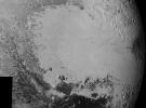
Mars Science Laboratory (MSL)
|
MAHLI
|
2015-11-11 |
573x438x3 |
|
- Title:
- Injection of Light Material into an Older Dark Vein
|
|
|
PIA19934 |
Pluto |
New Horizons
|
LORRI
|
2015-09-10 |
1217x1105x1 |
|
- Title:
- Chaos Region
|
|
|
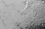
PIA19936 |
Pluto |
New Horizons
|
LORRI
|
2015-09-10 |
3446x2558x1 |
|
- Title:
- Surface Variety
|
|
|
PIA19943 |
Pluto |
New Horizons
|
MVIC
|
2015-09-17 |
1301x911x1 |
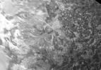
|
- Title:
- Intricate Valley Glaciers on Pluto
|
|
|
PIA19944 |
Pluto |
New Horizons
|
MVIC
|
2015-09-17 |
1330x860x1 |
|
- Title:
- Valley Glaciers on Pluto
|
|
|
PIA19947 |
Pluto |
New Horizons
|
MVIC
|
2015-09-17 |
2055x1321x1 |
|
- Title:
- Closer Look: Majestic Mountains and Frozen Plains
|