An unusually quiet start to the spring 2014 tornado season in the United States ended abruptly April 27, as a severe weather outbreak moved through the central and southern U.S. April 27-29. According to the National Weather Service, as of this morning, nearly 200 tornado warnings had been issued and more than 110 tornados had been reported, resulting in multiple fatalities across several states.
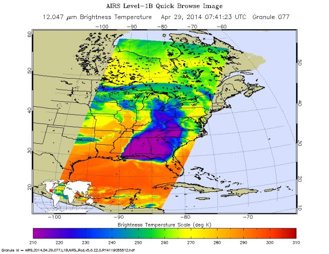
NASA's Aqua spacecraft passed over the region early in the morning on April 29 at 3:41 a.m. EDT (07:41 UTC). Its Atmospheric Infrared Sounder (AIRS) instrument captured this false-color infrared image of the slow-moving low-pressure system that spawned the strong supercell thunderstorms. The AIRS image showed very cold cloud top temperatures, indicating that the thunderstorms had strong uplift that pushed cloud tops near the top of the troposphere (Earth's lowest atmospheric layer). Temperatures drop to just under minus 64 degrees Fahrenheit (220 kelvin) at the top of the troposphere.
In the early morning imagery from April 29, AIRS data showed minimum cloud temperatures to be near minus 118 degrees Fahrenheit (190 kelvin), which is even colder than temperatures on April 28. This means the storms seen by AIRS on April 29 were higher in the atmosphere and had the potential to be stronger than those on April 28. On April 28, AIRS data showed some thunderstorms with cloud tops as cold as minus 100 degrees Fahrenheit (200 kelvin).
A low-pressure center associated with the fronts is located over Iowa. A warm front extends east of the low, bringing warm, moist air into the southeastern U.S. A stationary front stretches south from that low-pressure area to another low-pressure area over eastern Texas. NOAA's National Weather Service Storm Prediction Center is forecasting severe thunderstorms over parts of the U.S. Gulf Coast on April 29.
About AIRS
The Atmospheric Infrared Sounder, AIRS, in conjunction with the Advanced Microwave Sounding Unit, AMSU, senses emitted infrared and microwave radiation from Earth to provide a three-dimensional look at Earth's weather and climate. Working in tandem, the two instruments make simultaneous observations all the way down to Earth's surface, even in the presence of heavy clouds. With more than 2,000 channels sensing different regions of the atmosphere, the system creates a global, three-dimensional map of atmospheric temperature and humidity, cloud amounts and heights, greenhouse gas concentrations, and many other atmospheric phenomena. Launched into Earth orbit in 2002, the AIRS and AMSU instruments fly onboard NASA's Aqua spacecraft and are managed by NASA's Jet Propulsion Laboratory in Pasadena, Calif., under contract to NASA. JPL is a division of the California Institute of Technology in Pasadena.
More information about AIRS can be found at http://airs.jpl.nasa.gov.