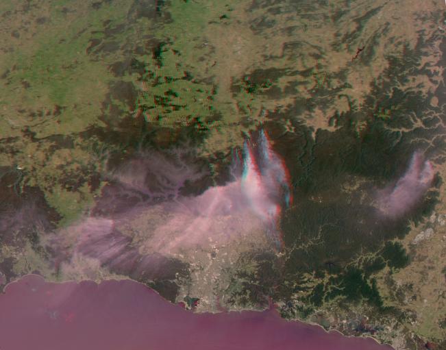
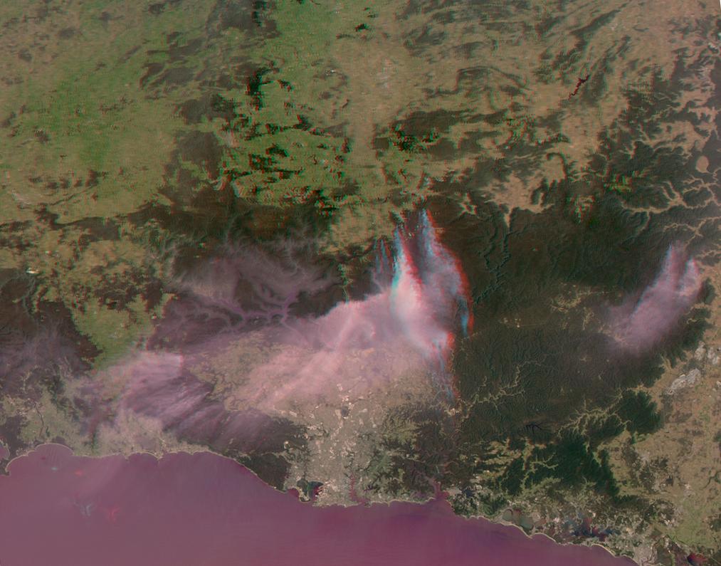
A mild winter and an extremely hot September in Australia have led to an early start to the fire season Down Under. A number of significant bush fires continue to rage in the Blue Mountains to the west and north of Sydney, the most populous city in the country, with nearly 4.6 million people. The ongoing fires have led to the announcement of a state of emergency for the area, and days of high temperatures and strong winds have exacerbated the situation.
The Multi-angle Imaging SpectroRadiometer (MISR) instrument on NASA's Terra spacecraft passed over the region around 11:00 a.m. AEDT (00:00 UTC) on Oct. 20, 2013. This stereo anaglyph is a composite of images from two of MISR's nine cameras; the nadir (0°) camera is shown in the blue/green channels and the Ba (45.6° aft) camera is shown in the red channel. The images have been rotated clockwise so that north is to the right and west is toward the top. The anaglyph can be viewed with standard red/blue 3D glasses with the red lens over the left eye.
Sydney itself is in the bottom center of the image, with much of its area covered by a thin cloud of smoke. The Blue Mountains rise about 0.6 miles (1 kilometer) above sea level, and analysis of the MISR data shows that the plume extending over the city is at an altitude of just over 1 mile (2 kilometers). On this date, the winds were relatively light and the temperature was around 77 degrees Fahrenheit (25 degrees Celsius). The fires to the north have plumes that are somewhat lower in altitude.
The image extends from about 32.35 degrees south to 34.8 degrees south and 149.1 degrees east to 151.8 degrees east, covering about 168 miles (270 kilometers) in the north-south direction and 158 miles (255 kilometers) in the east-west direction. The images are a portion of the data acquired during Terra orbit 73608 from blocks 116 to 118 within World Reference System-2 path 90.
MISR was built and is managed by NASA's Jet Propulsion Laboratory, Pasadena, Calif., for NASA's Science Mission Directorate, Washington, D.C. The Terra spacecraft is managed by NASA's Goddard Space Flight Center, Greenbelt, Md. The MISR data were obtained from the NASA Langley Research Center Atmospheric Science Data Center, Hampton, Va. JPL is a division of the California Institute of Technology in Pasadena.