My
List |
Addition Date
|
Target
|
Mission
|
Instrument
|
Size
|

|
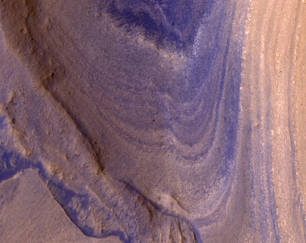
2024-10-10 |
Mars
|
Mars Reconnaissance Orbiter (MRO)
|
HiRISE
|
1998x1223x1 |

|
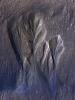
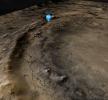
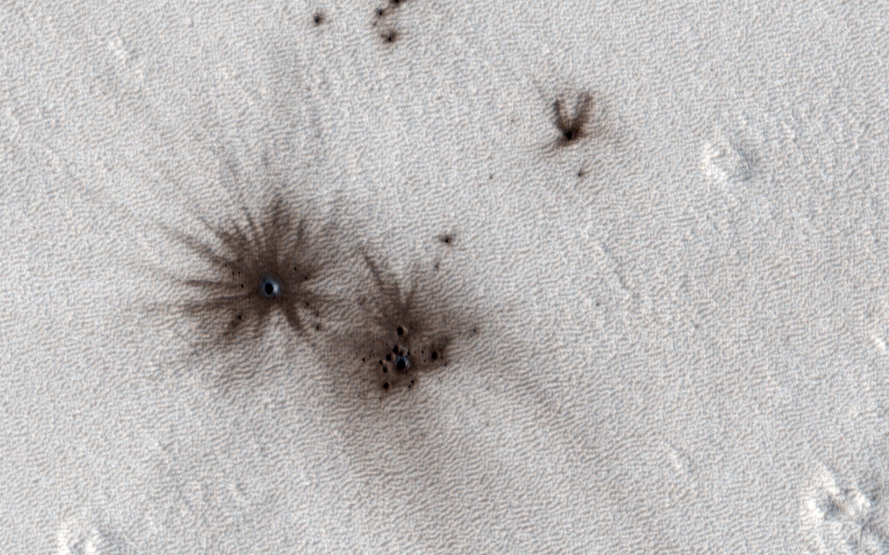
-
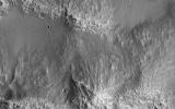
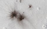
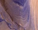
PIA26408:
-
Dusty Water Ice in Mars' Dao Vallis
Full Resolution:
TIFF
(2.361 MB)
JPEG
(310.2 kB)
|
|
|
2024-10-10 |
Mars
|
Mars Reconnaissance Orbiter (MRO)
|
HiRISE
|
3232x4333x3 |
|
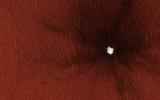
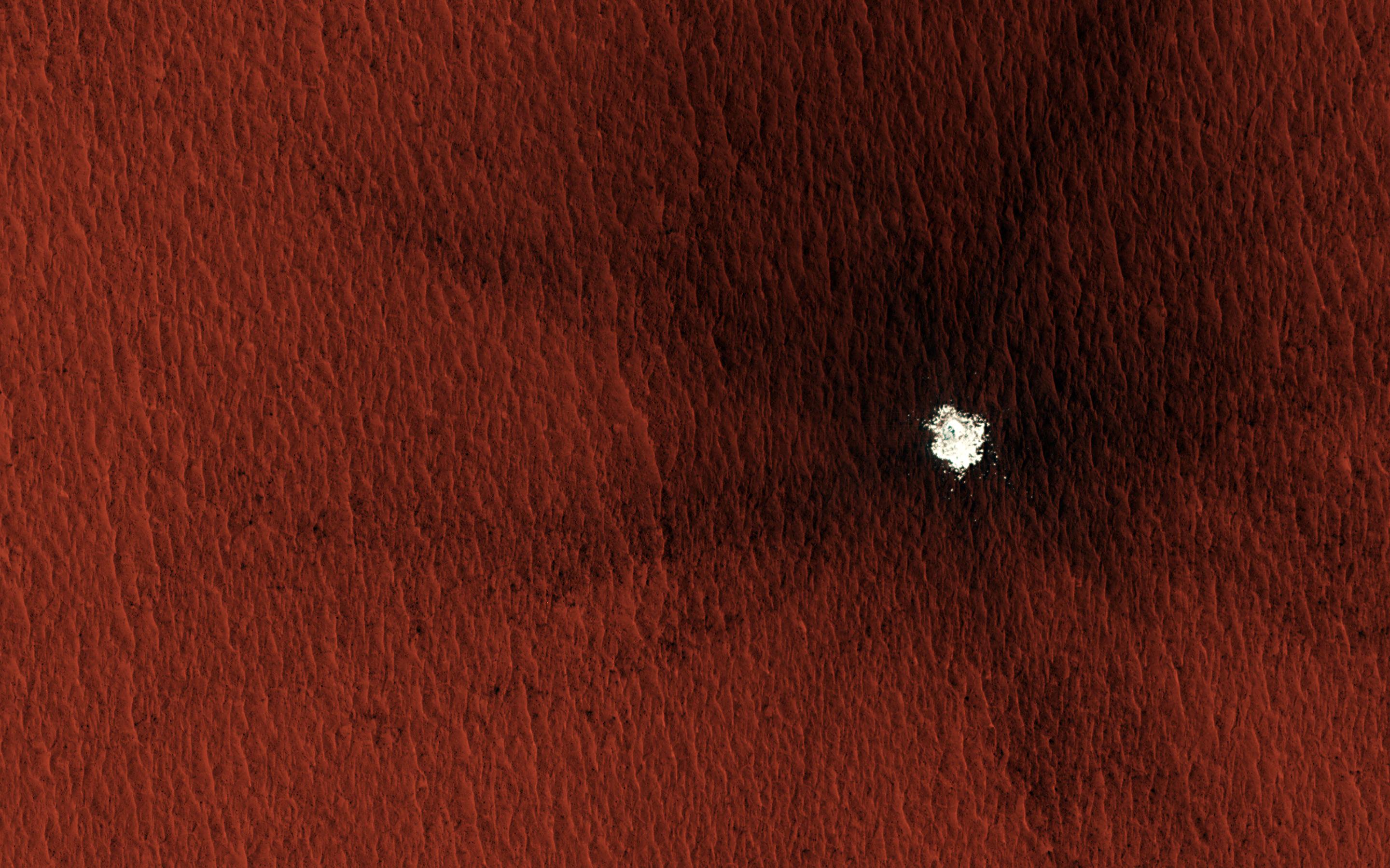
-
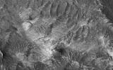
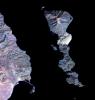
PIA26407:
-
Dusty Water Ice in Mars' Terra Sirenum
Full Resolution:
TIFF
(41.04 MB)
JPEG
(1.397 MB)
|
|
|
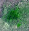
2024-10-09 |
Earth
|
|
ASTER
MODIS
|
1440x1090x3 |
|
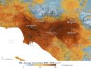
-
PIA26415:
-
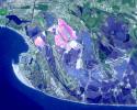
Particulate Pollution and Warehouses in the Los Angeles Region
Full Resolution:
TIFF
(3.991 MB)
JPEG
(272.1 kB)
|
|
|
2024-10-02 |
Asteroid
|
|
ATLAS
|
1367x970x3 |
|
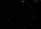
-
PIA26452:
-
Asteroid 2024 PT5's Orbit Around the Sun (Animation)
Full Resolution:
TIFF
(195.3 kB)
JPEG
(38.41 kB)
|
|
|
2024-10-02 |
Earth
|
|
SAR
|
2480x3507x3 |
|
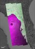
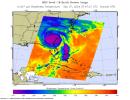
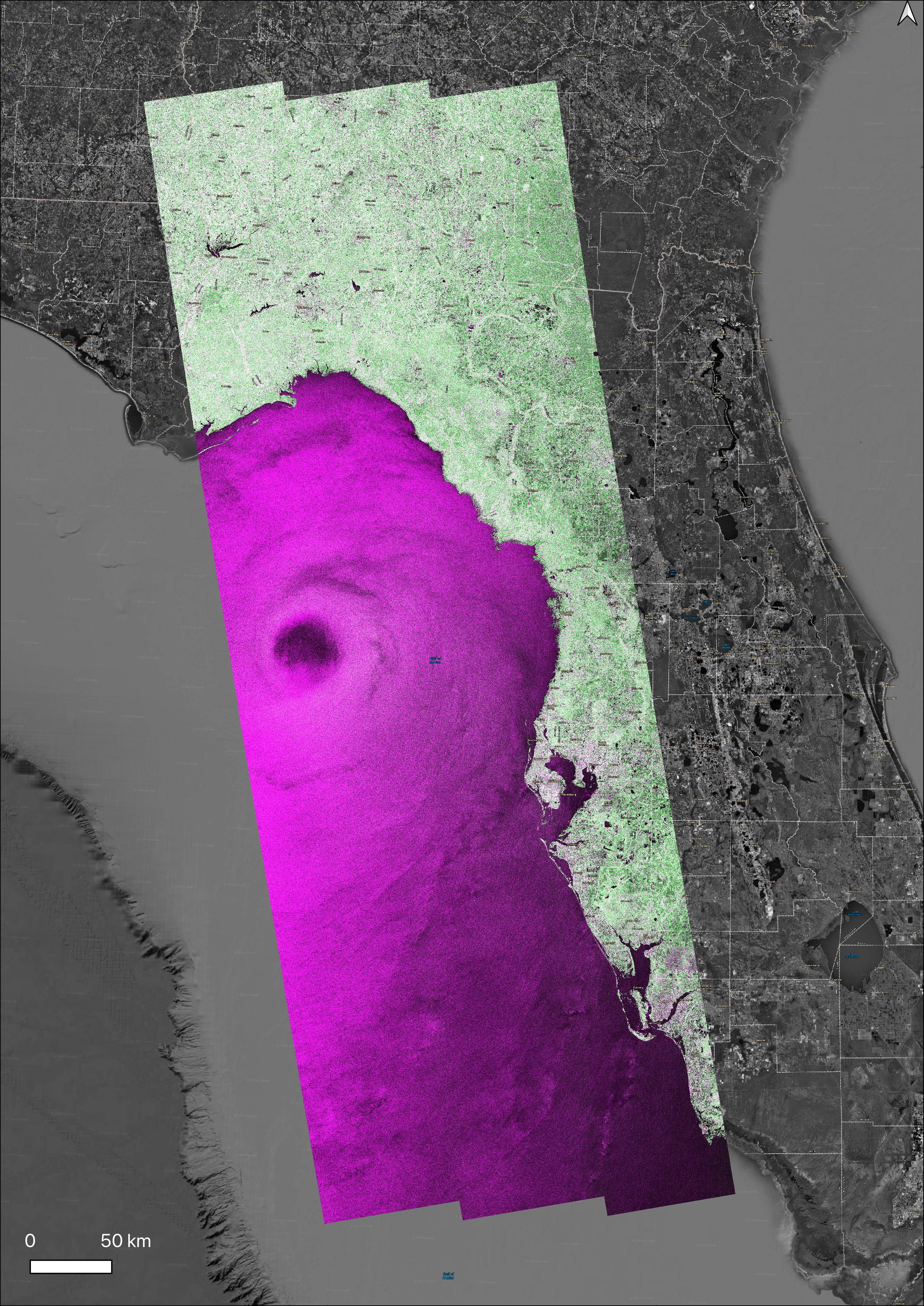
-
PIA26414:
-
NASA's OPERA Project Generates Radar Image of Hurricane Helene
Full Resolution:
TIFF
(18.81 MB)
JPEG
(2.337 MB)
|
|
|
2024-09-27 |
Earth
|
Aqua
|
AIRS
|
900x695x3 |
|
-
PIA26413:
-
NASA's AIRS Instrument Captures Hurricane Helene
Full Resolution:
TIFF
(805.8 kB)
JPEG
(118 kB)
|
|
|
2024-09-27 |
Earth
|
Terra
|
ASTER
|
1073x1143x3 |
|
-
PIA26395:
-
Araxa Mine, Brazil
Full Resolution:
TIFF
(3.681 MB)
JPEG
(251.1 kB)
|
|
|
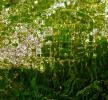
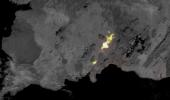
2024-09-25 |
Earth
|
Carbon Mapper Coalition
|
Carbon Mapper Imaging Spectrometer
|
1133x1326x3 |
|
-
PIA26412:
-
Tanager-1 First Light
Full Resolution:
TIFF
(2.663 MB)
JPEG
(215.2 kB)
|
|
|
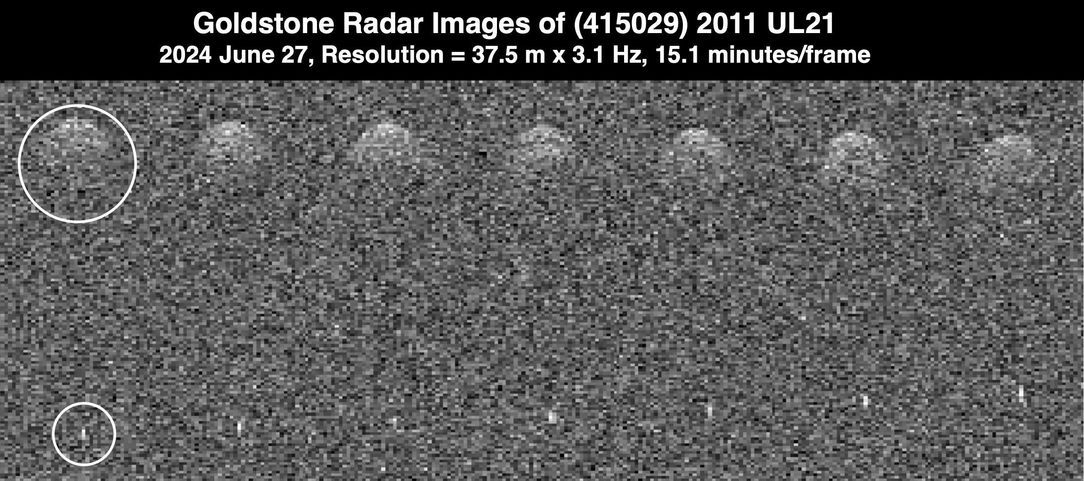
2024-09-17 |
Asteroid
|
Deep Space Network (DSN)
|
Deep Space Network
|
4757x3262x1 |
|
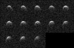
-
PIA26451:
-
NASA's Planetary Radar Spies (Another) Peanut-Shaped Asteroid
Full Resolution:
TIFF
(11.11 MB)
JPEG
(3.026 MB)
|
|
|
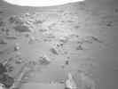
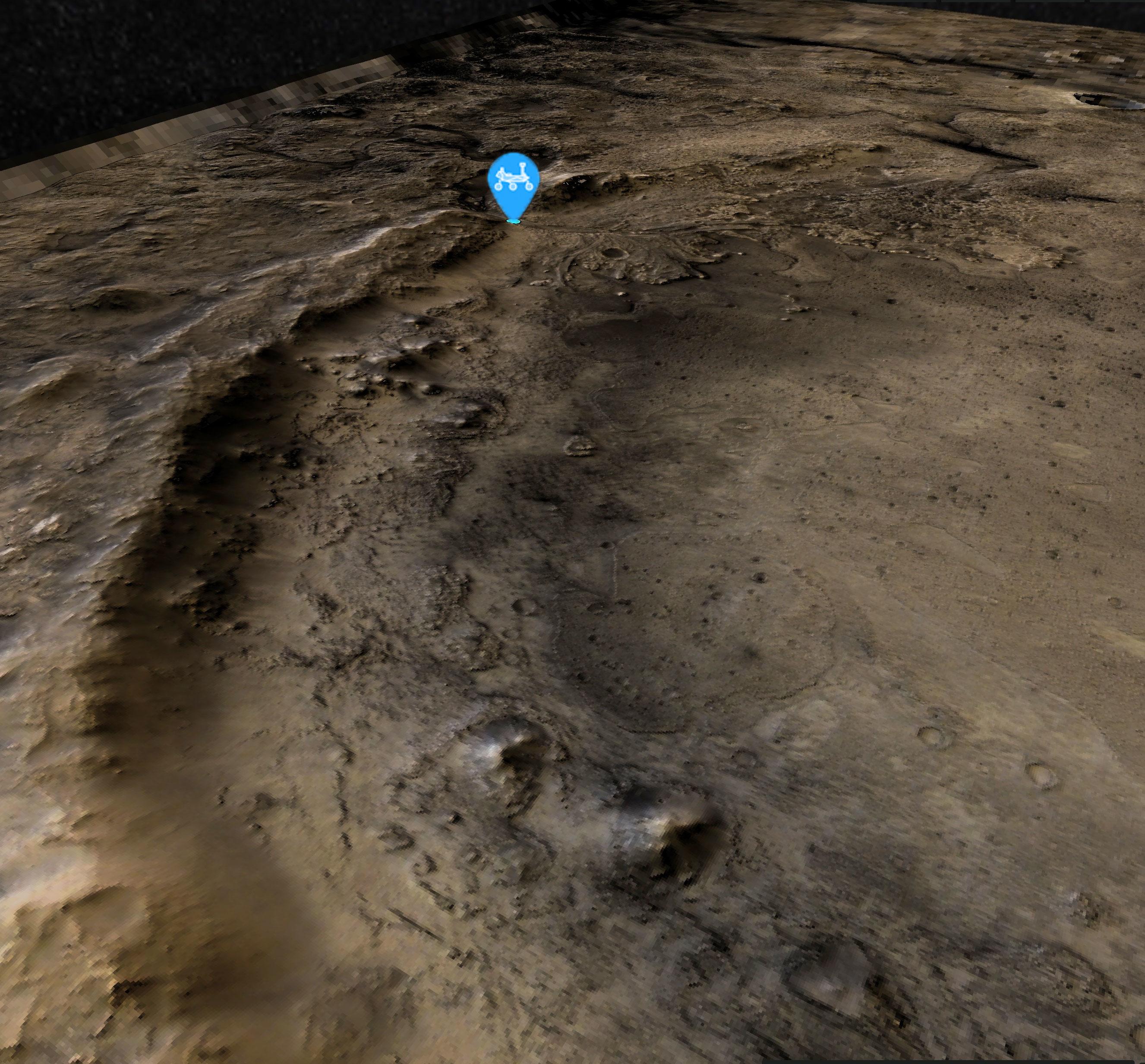
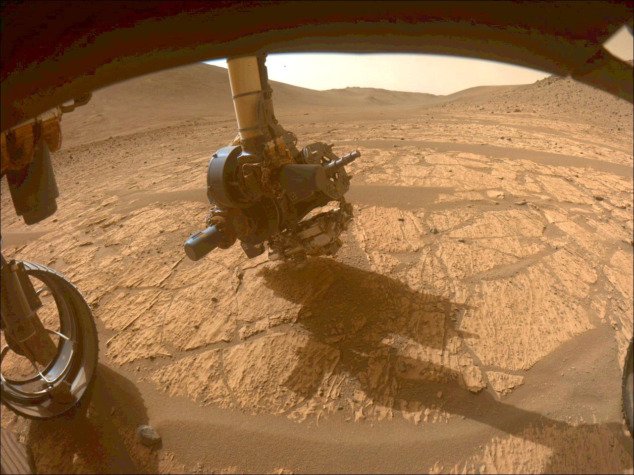
2024-09-13 |
Mars
|
Mars 2020 Rover
|
Navigation Camera (M2020)
|
1280x960x1 |
|
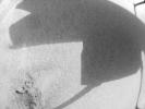
-
PIA26376:
-
NASA's Perseverance Is Going Up and Up
Full Resolution:
TIFF
(701.1 kB)
JPEG
(151 kB)
|
|
|
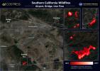
2024-09-13 |
Earth
|
ECOSTRESS
|
|
3507x2480x3 |
|
-
PIA26187:
-
Southern California Wildfires Captured by NASA's ECOSTRESS
Full Resolution:
TIFF
(19.8 MB)
JPEG
(1.341 MB)
|
|
|
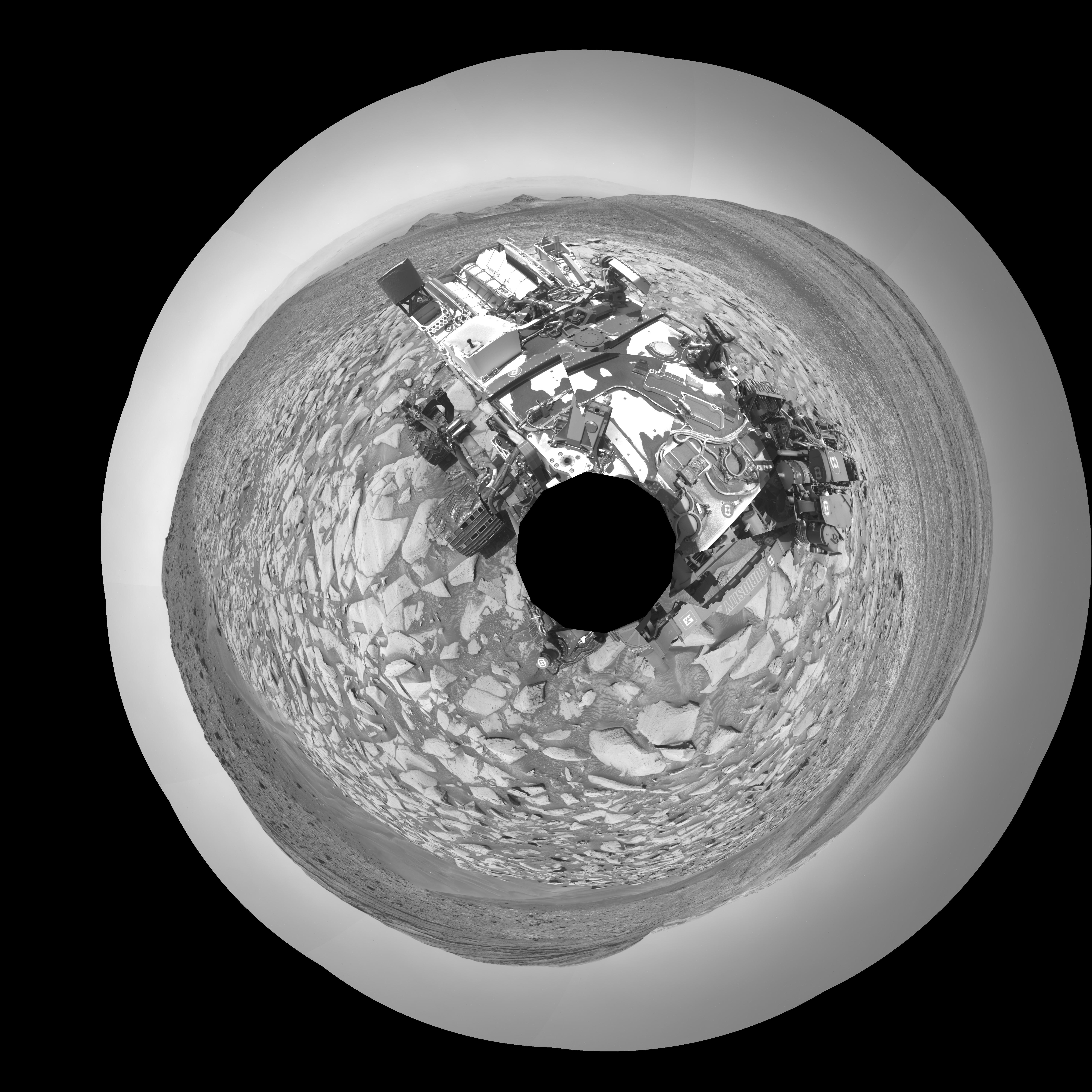
2024-09-13 |
Mars
|
Mars Science Laboratory (MSL)
|
Mastcam
|
1080x2100x3 |

|
-
PIA26362:
-
Curiosity Views Earth Setting, Phobos Rising
Full Resolution:
TIFF
(4.06 MB)
JPEG
(111.7 kB)
|
|
|
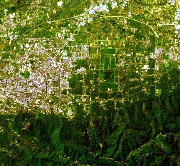
2024-08-30 |
Earth
|
Terra
|
ASTER
|
613x565x3 |
|
-
PIA26394:
-
Terra Cotta Army, China
Full Resolution:
TIFF
(1.04 MB)
JPEG
(103 kB)
|
|
|
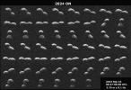
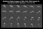
2024-08-29 |
Asteroid
|
Deep Space Network (DSN)
|
Deep Space Network
|
1474x990x1 |
|
-
PIA26389:
-
Goldstone Planetary Radar Observes Peanut-Shaped Asteroid
Full Resolution:
TIFF
(1.226 MB)
JPEG
(269.2 kB)
|
|
|
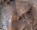
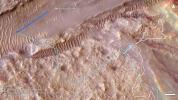
2024-08-27 |
Mars
|
Mars Reconnaissance Orbiter (MRO)
|
HiRISE
|
2653x2464x3 |
|
-
PIA26402:
-
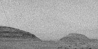
Perseverance's Location at the Base of Jezero Crater's Rim
Full Resolution:
TIFF
(16.77 MB)
JPEG
(874.2 kB)
|
|
|
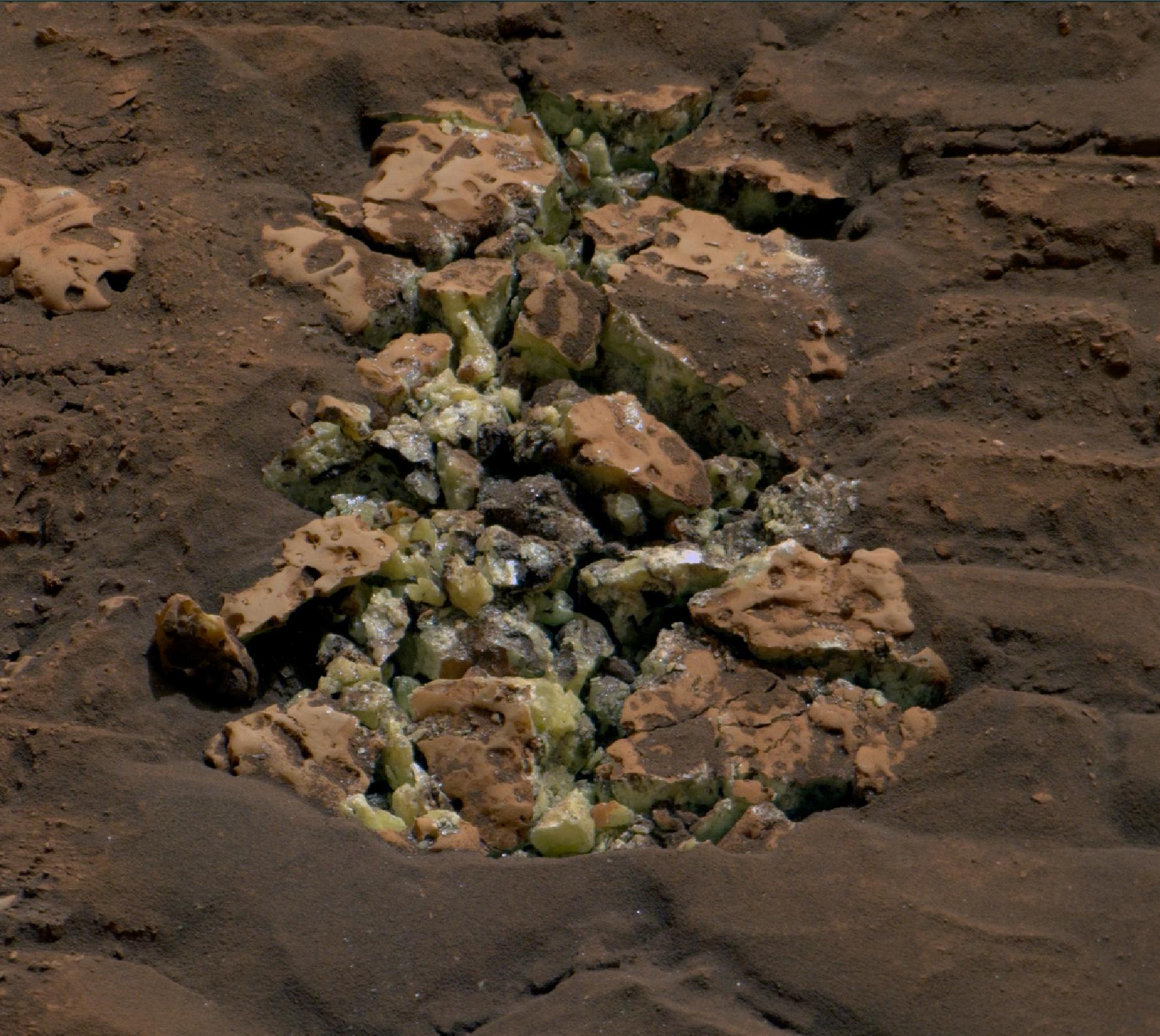
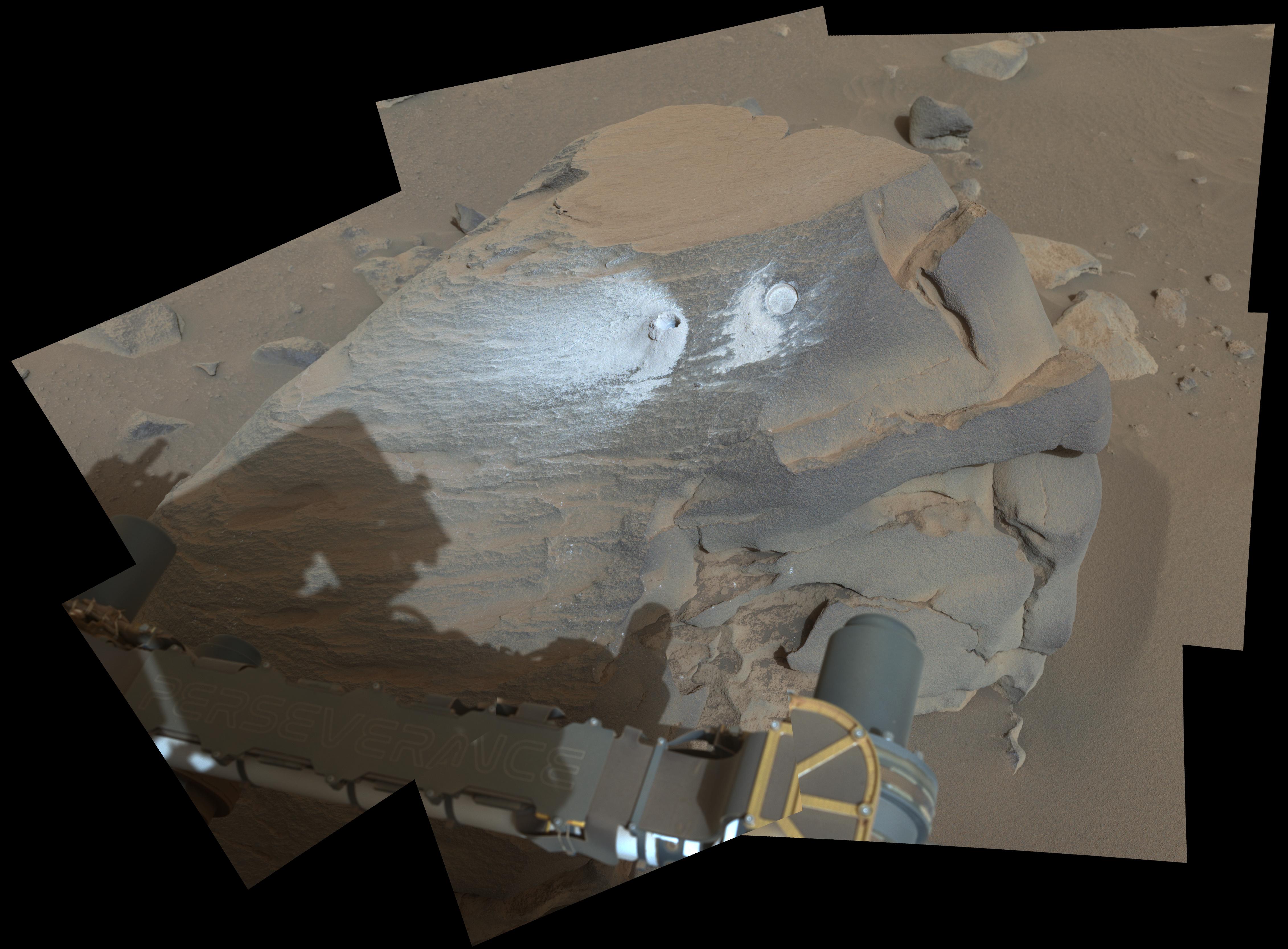
2024-08-27 |
Mars
|
Mars Science Laboratory (MSL)
|
MAHLI
|
4200x2700x3 |
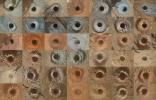
|
-
PIA26403:
-
Curiosity's 42 Drill Holes
Full Resolution:
TIFF
(34.04 MB)
JPEG
(2.717 MB)
|
|
|
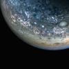
2024-08-20 |
Jupiter
|
Juno
|
JunoCam
|
3772x2122x3 |
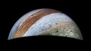
|
-
PIA26350:
-
JunoCam Captures Jupiter on 62nd Flyby
Full Resolution:
TIFF
(9.624 MB)
JPEG
(365.7 kB)
|
|
|
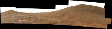
2024-08-14 |
Mars
|
Mars Reconnaissance Orbiter (MRO)
|
HiRISE
|
1129x929x3 |
|
-
PIA26374:
-
Perseverance's Climb to 'Witch Hazel Hill'
Full Resolution:
TIFF
(3.148 MB)
JPEG
(155.5 kB)
|
|
|
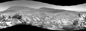
2024-08-14 |
Mars
|
Mars 2020 Rover
|
Mastcam-Z
|
22332x5856x3 |
|
-
PIA26373:
Perseverance Rover's View Up Crater
Full Resolution:
TIFF
(195.4 MB)
JPEG
(14.3 MB)
|
|
|
2024-08-14 |
Mars
|
Mars 2020 Rover
|
Navigation Camera (M2020)
|
2560x1920x3 |
|
-
PIA26372:
-
Perseverance Looks Back at 'Bright Angel'
Full Resolution:
TIFF
(9.854 MB)
JPEG
(676.2 kB)
|
|
|
2024-08-07 |
Earth
|
Terra
|
ASTER
|
799x773x3 |
|
-
PIA26393:
-
Tofua Island, Tonga Islands
Full Resolution:
TIFF
(1.49 MB)
JPEG
(59.23 kB)
|
|
|
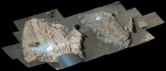
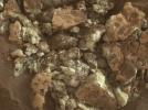
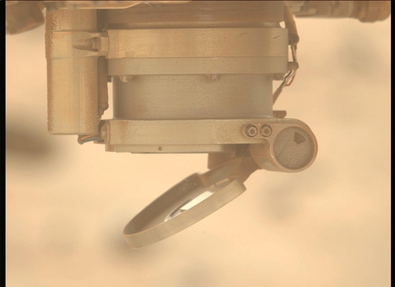
2024-07-25 |
Mars
|
Mars 2020 Rover
|
Scanning Habitable Environments with Raman & Luminescence for Organics and Chemicals (SHERLOC)
|
10502x7458x3 |
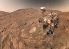
|
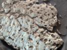
-
PIA26344:
-
Perseverance's Selfie With 'Cheyava Falls'
Full Resolution:
TIFF
(189.5 MB)
JPEG
(7.951 MB)
|
|
|
2024-07-25 |
Mars
|
Mars 2020 Rover
|
Mastcam-Z
|
14444x6175x3 |
|
-
PIA26401:
-
Mastcam-Z Views the 'Cheyava Falls' Workspace
Full Resolution:
TIFF
(160.2 MB)
JPEG
(10.14 MB)
|
|
|
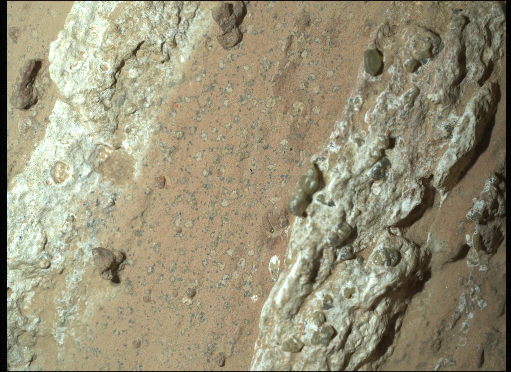
2024-07-25 |
Mars
|
Mars 2020 Rover
|
Mastcam-Z
|
1471x1400x3 |
|
-
PIA26370:
-
Mastcam-Z Views 'Leopard Spots' in Perseverance's Drill Bit
Full Resolution:
TIFF
(6.181 MB)
JPEG
(222.4 kB)
|
|
|
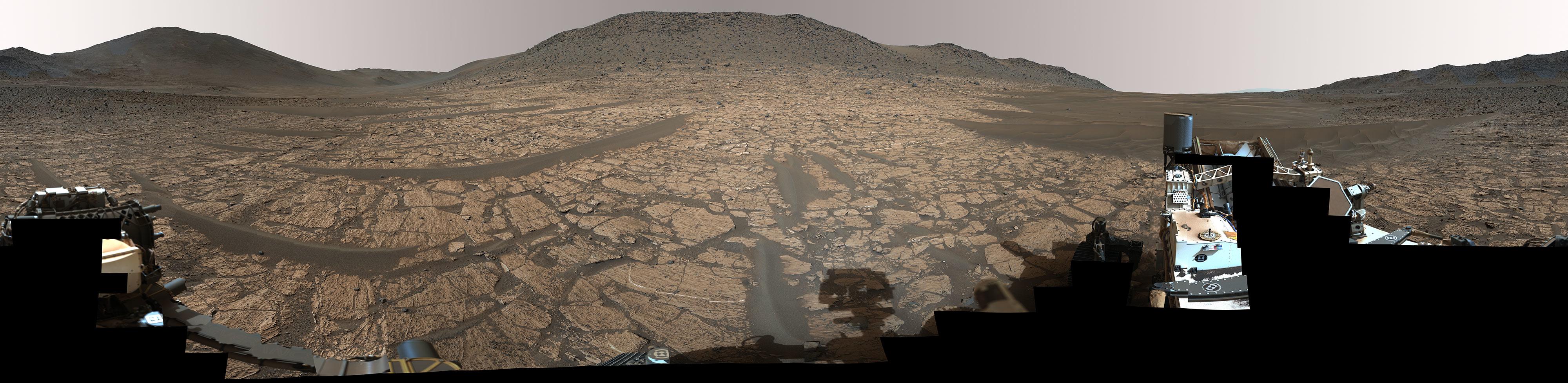
2024-07-25 |
Mars
|
Mars 2020 Rover
|
Mastcam-Z
|
27000x6600x3 |

|
-
PIA26369:
Perseverance Captures 'Bright Angel' in 360 Degrees
Full Resolution:
TIFF
(387 MB)
JPEG
(23.66 MB)
|
|
|
2024-07-25 |
Mars
|
Mars 2020 Rover
|
Scanning Habitable Environments with Raman & Luminescence for Organics and Chemicals (SHERLOC)
|
1648x1200x3 |

|
-
PIA26368:
-
Perseverance Finds a Rock With 'Leopard Spots'
Full Resolution:
TIFF
(5.935 MB)
JPEG
(324.1 kB)
|
|
|
2024-07-19 |
Earth
|
Terra
|
ASTER
|
1777x1921x3 |
|
-
PIA26392:
-
Mount Mabu, Mozambique
Full Resolution:
TIFF
(10.24 MB)
JPEG
(796.9 kB)
|
|
|
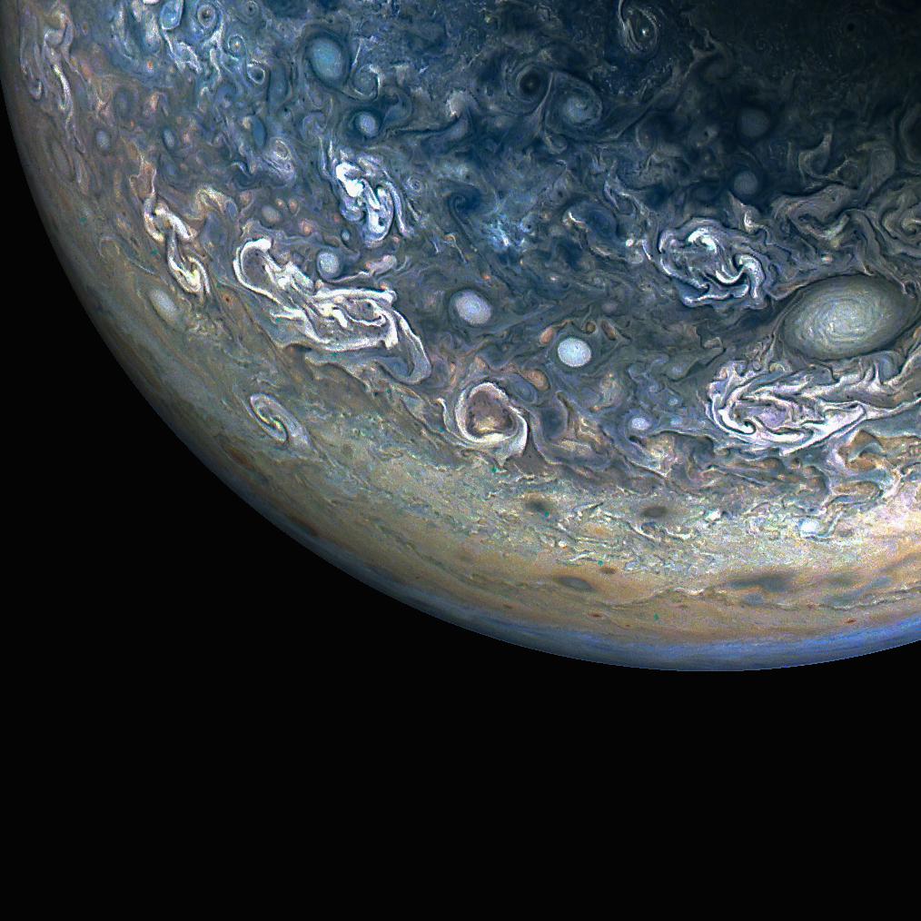
2024-07-19 |
Jupiter
|
Juno
|
JunoCam
|
1014x1014x3 |
|
-
PIA25729:
-
NASA's Juno Mission Captures the Colorful and Chaotic Clouds of Jupiter
Full Resolution:
TIFF
(2.268 MB)
JPEG
(135.2 kB)
|
|
|
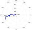
2024-07-19 |
Earth
|
|
|
1654x1578x3 |
|
-
PIA26120:
-
Meandering Path of Earth's Spin Axis
Full Resolution:
TIFF
(362.3 kB)
JPEG
(108.7 kB)
|
|
|
2024-07-18 |
Mars
|
Mars Science Laboratory (MSL)
|
Mastcam
|
15169x4445x3 |
|
-
PIA26364:
-
Curiosity's Detailed View of 'Fascination Turret'
Full Resolution:
TIFF
(126 MB)
JPEG
(12.16 MB)
|
|
|
2024-07-18 |
Mars
|
Mars Science Laboratory (MSL)
|
Mastcam
|
29240x8311x3 |
|
-
PIA26363:
Curiosity Takes a 360-Degree View of Gediz Vallis Channel
Full Resolution:
TIFF
(449.3 MB)
JPEG
(34.34 MB)
|
|
|
2024-07-18 |
Mars
|
Mars Science Laboratory (MSL)
|
MAHLI
|
1607x1196x3 |
|
-
PIA26307:
-
Curiosity Captures Close-Up of Sulfur Crystals
Full Resolution:
TIFF
(5.768 MB)
JPEG
(322.3 kB)
|
|
|
2024-07-18 |
Mars
|
Mars Science Laboratory (MSL)
|
Mastcam
|
22115x5629x3 |
|
-
PIA26366:
Curiosity Views Rocks With 'Halos'
Full Resolution:
TIFF
(170 MB)
JPEG
(17.1 MB)
|
|
|
2024-07-18 |
Mars
|
Mars Science Laboratory (MSL)
|
Mastcam
|
16155x5850x3 |
|
-
PIA26367:
-
Curiosity Views Gediz Vallis Channel
Full Resolution:
TIFF
(230.6 MB)
JPEG
(19.43 MB)
|
|
|
2024-07-18 |
Mars
|
Mars Science Laboratory (MSL)
|
MAHLI
|
1607x1196x3 |
|
-
PIA26308:
-
Curiosity Views Rock Made of Sulfur at 'Snow Lake'
Full Resolution:
TIFF
(5.768 MB)
JPEG
(410 kB)
|
|
|
2024-07-18 |
Mars
|
Mars Science Laboratory (MSL)
|
Mastcam
|
1779x1590x3 |
|
-
PIA26309:
-
Curiosity Views Sulfur Crystals Within a Crushed Rock
Full Resolution:
TIFF
(8.072 MB)
JPEG
(398.4 kB)
|
|
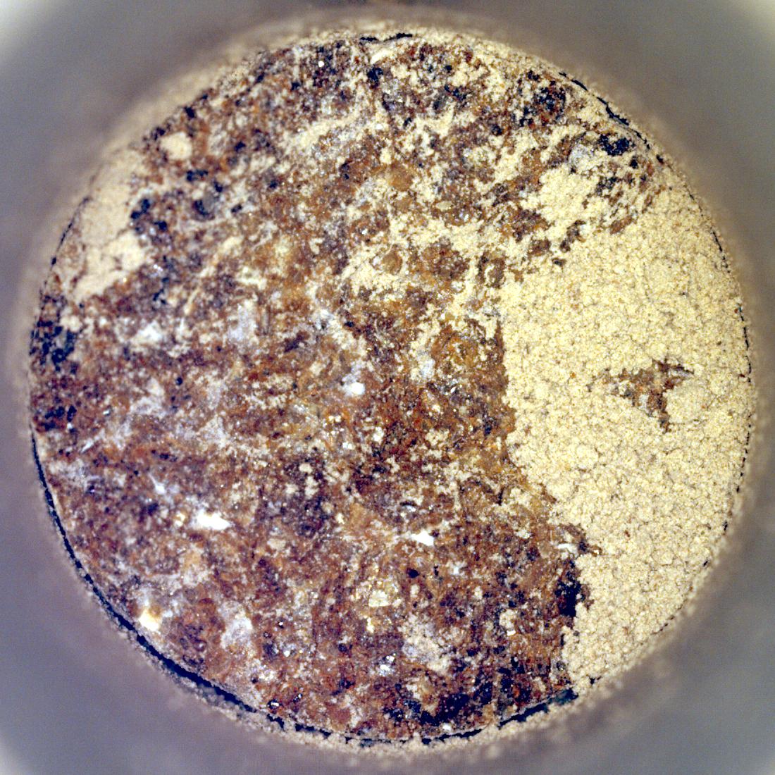
|
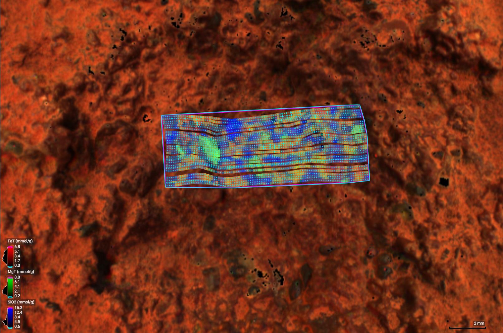
2024-07-16 |
Mars
|
Mars 2020 Rover
|
Planetary Instrument for X-ray Lithochemistry (PIXL)
|
1614x1070x3 |

|
-
PIA26365:
-
Perseverance's PIXL Instrument Examines 'Thunderbolt Peak'
Full Resolution:
TIFF
(5.183 MB)
JPEG
(219.9 kB)
|
|
|
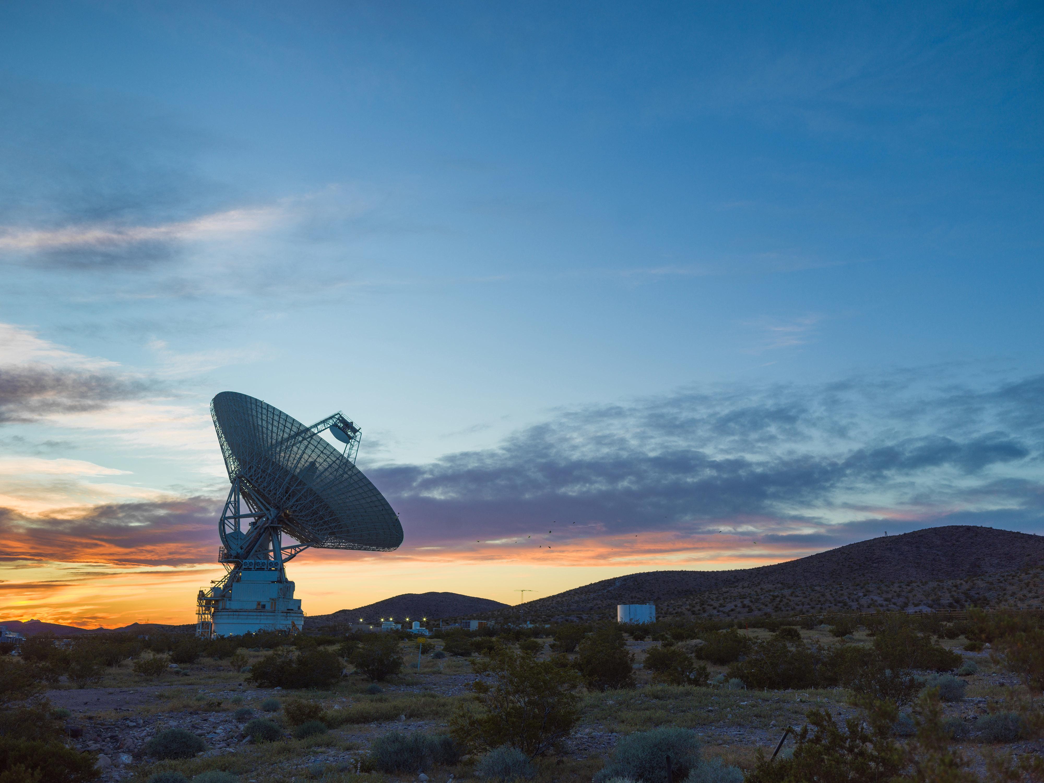
2024-07-03 |
Asteroid
|
Deep Space Network (DSN)
|
Deep Space Network
|
4000x3000x3 |
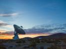
|
-
PIA26150:
-
The Goldstone Solar System Radar at Sunset
Full Resolution:
TIFF
(24.75 MB)
JPEG
(985.8 kB)
|
|
|
2024-07-03 |
Asteroid
|
Deep Space Network (DSN)
|
Deep Space Network
|
2192x974x1 |
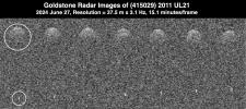
|
-
PIA26384:
-
Goldstone Planetary Radar Observes Binary Asteroid 2011 UL21
Full Resolution:
TIFF
(1.765 MB)
JPEG
(357 kB)
|
|
|
2024-07-03 |
Asteroid
|
Deep Space Network (DSN)
|
Deep Space Network
|
7202x8058x1 |
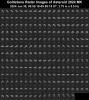
|
-
PIA26383:
-
Detailed Planetary Radar Observations of Asteroid 2024 MK
Full Resolution:
TIFF
(25.86 MB)
JPEG
(5.619 MB)
|
|
|
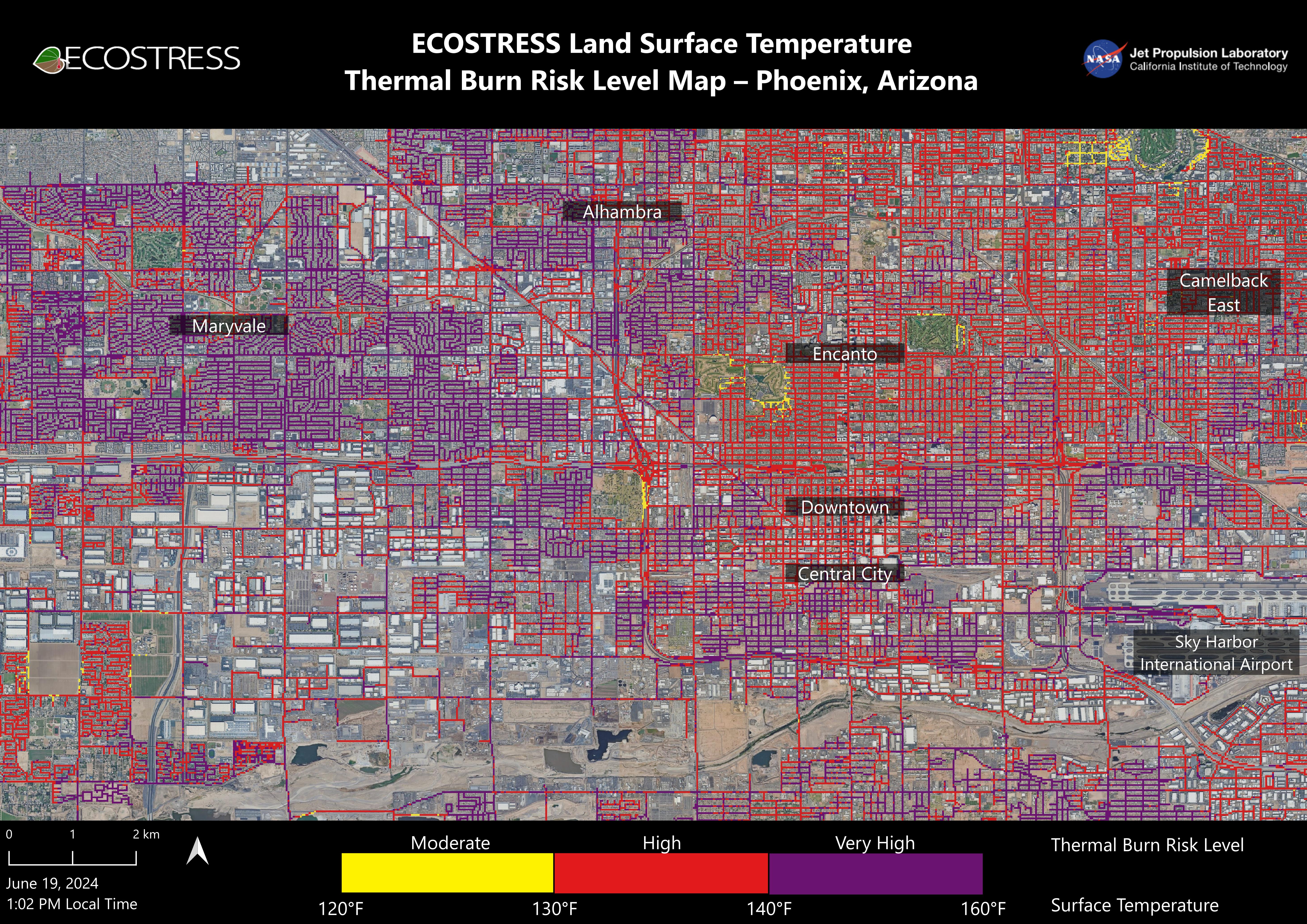
2024-07-02 |
Earth
|
ECOSTRESS
|
ECOSTRESS
|
5846x4133x3 |
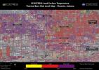
|
-
PIA25529:
-
NASA's ECOSTRESS Maps Burn Risk Across Phoenix Streets
Full Resolution:
TIFF
(56.15 MB)
JPEG
(5.17 MB)
|
|
|
2024-06-27 |
Earth
|
Terra
|
ASTER
|
1129x1013x3 |
|
-
PIA26391:
-
Handa Island, Scotland
Full Resolution:
TIFF
(3.026 MB)
JPEG
(189 kB)
|
|
|
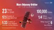
2024-06-27 |
Mars
|
2001 Mars Odyssey
|
THEMIS
|
1920x1080x3 |
|
-
PIA26361:
-
Odyssey's Accomplishments at Its 100,000th Orbit
Full Resolution:
TIFF
(5.213 MB)
JPEG
(209.6 kB)
|
|
|
2024-06-27 |
Mars
|
2001 Mars Odyssey
|
THEMIS
|
14152x1600x3 |

|
-
PIA26305:
Odyssey's THEMIS Views Olympus Mons
Full Resolution:
TIFF
(37.75 MB)
JPEG
(1.634 MB)
|
|
|
2024-06-26 |
Mars
|
Mars 2020 Rover
|
Hazard Avoidance Camera (M2020)
|
1280x960x3 |
|
-
PIA26320:
-
Perseverance's Abrasion Patch at 'Walhalla Glades'
Full Resolution:
TIFF
(2.686 MB)
JPEG
(204.5 kB)
|
|
|
2024-06-26 |
Mars
|
Mars 2020 Rover
|
Mastcam-Z
|
1648x1200x3 |
|
-
PIA26338:
-
Moving the Lens Cover on Perseverance's SHERLOC
Full Resolution:
TIFF
(3 MB)
JPEG
(122.7 kB)
|
|
|
2024-06-26 |
Mars
|
Mars 2020 Rover
|
Navigation Camera (M2020)
|
1280x480x3 |
|
-
PIA26339:
-
Checking the Cover on Perseverance's SHERLOC
Full Resolution:
TIFF
(523.6 kB)
JPEG
(53.46 kB)
|
|
|
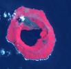
2024-06-21 |
Earth
|
Terra
|
ASTER
|
419x380x3 |

|
-
PIA26326:
-
Fernandina Volcano, Galapagos
Full Resolution:
TIFF
(357.3 kB)
JPEG
(20.66 kB)
|
|
|
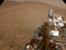
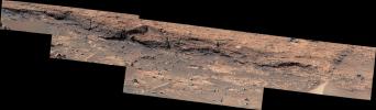
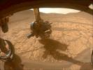
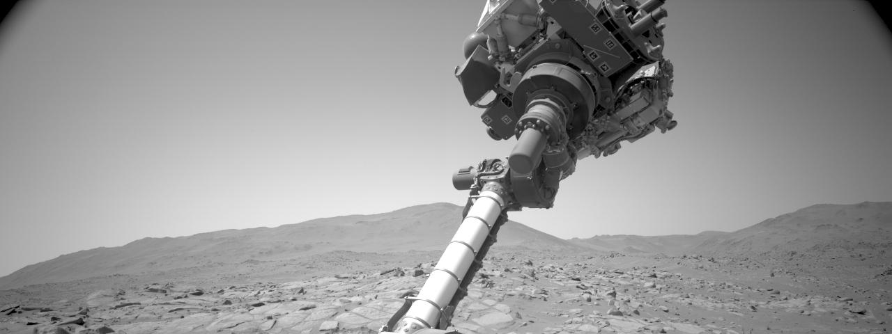
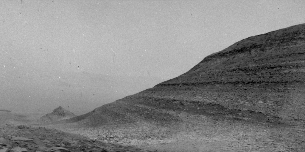
2024-06-13 |
Mars
|
Mars 2020 Rover
|
Navigation Camera (M2020)
|
2557x790x3 |
|
-
PIA26336:
-
Perseverance Views 'Bright Angel'
Full Resolution:
TIFF
(4.31 MB)
JPEG
(342.2 kB)
|
|
|
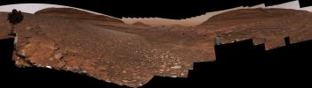
2024-06-13 |
Mars
|
Mars 2020 Rover
|
Mastcam-Z
|
26911x3744x3 |
|
-
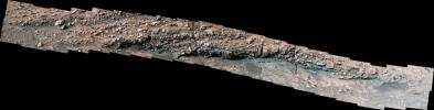
PIA26335:
Perseverance's View of Neretva Vallis River Channel
Full Resolution:
TIFF
(194.1 MB)
JPEG
(8.016 MB)
|
|
|
2024-06-13 |
Mars
|
Mars Reconnaissance Orbiter (MRO)
|
HiRISE
|
1627x757x3 |

|
-
PIA26334:
-
Perseverance's Path to 'Bright Angel' in Mars' Jezero Crater
Full Resolution:
TIFF
(3.696 MB)
JPEG
(286.5 kB)
|
|
|
2024-06-13 |
Mars
|
Mars 2020 Rover
|
Mastcam-Z
|
12657x2680x3 |
|
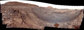
-
PIA26333:
Standing Out on Mars' 'Mount Washburn'
Full Resolution:
TIFF
(68.05 MB)
JPEG
(3.459 MB)
|
|
|
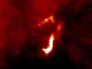
2024-06-10 |
Mars
|
MAVEN
|
Imaging Ultraviolet Spectrograph (IUVS)
|
1800x1800x3 |

|
-
PIA26304:
-
MAVEN Detects Auroras During Solar Storm in 2024
Full Resolution:
TIFF
(4.746 MB)
JPEG
(186.8 kB)
|
|
|
2024-06-10 |
Mars
|
Mars Science Laboratory (MSL)
|
Navcam (MSL)
|
1024x512x3 |

|
-
PIA26303:
-
Curiosity Sees Specks Caused By 2024 Solar Storm While Recording a Wind Gust on Mars
Full Resolution:
TIFF
(470.6 kB)
JPEG
(70.9 kB)
|
|
|
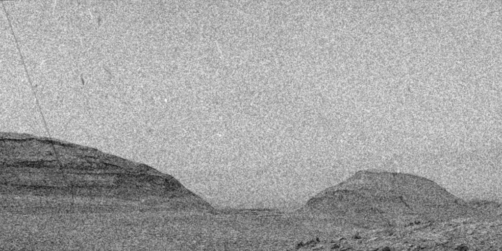
2024-06-10 |
Mars
|
Mars Science Laboratory (MSL)
|
Navcam (MSL)
|
1024x512x3 |
|
-
PIA26302:
-
Curiosity Sees Streaks and Specks During 2024 Solar Storm
Full Resolution:
TIFF
(525 kB)
JPEG
(114.3 kB)
|
|
|
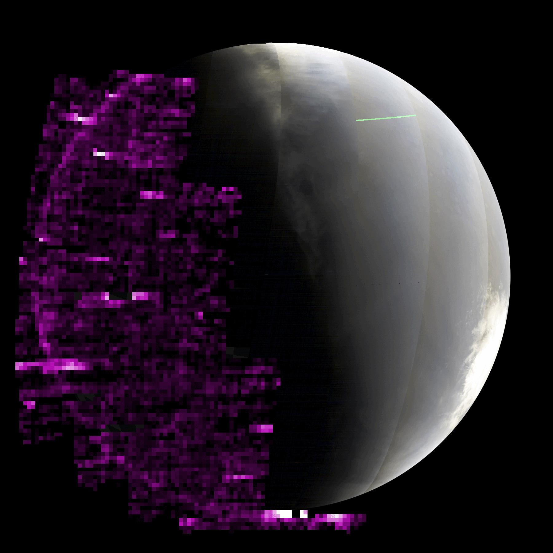
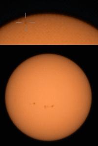
2024-06-10 |
Sol (our sun)
|
Mars 2020 Rover
|
Mastcam-Z
|
256x256x3 |
|
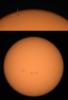
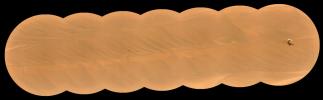
-
PIA26301:
-
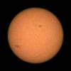
Perseverance Views Sunspots
Full Resolution:
TIFF
(83.3 kB)
JPEG
(5.605 kB)
|
|
|
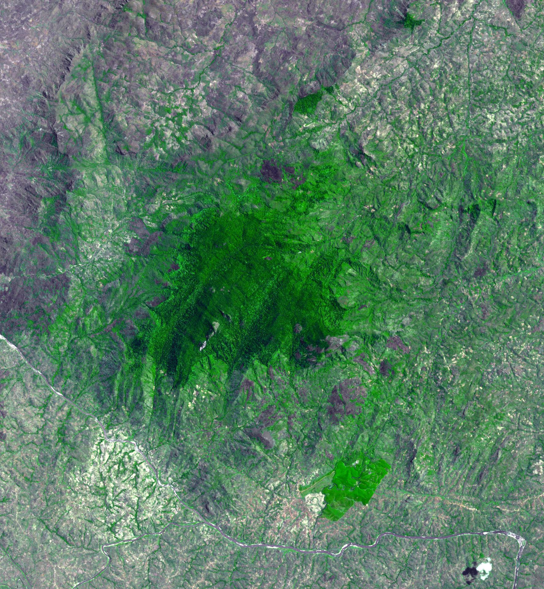
2024-05-30 |
Earth
|
Terra
|
ASTER
|
1219x978x3 |
|
-
PIA26325:
-
Salin-de-Giraud, France
Full Resolution:
TIFF
(3.578 MB)
JPEG
(225.7 kB)
|
|
|
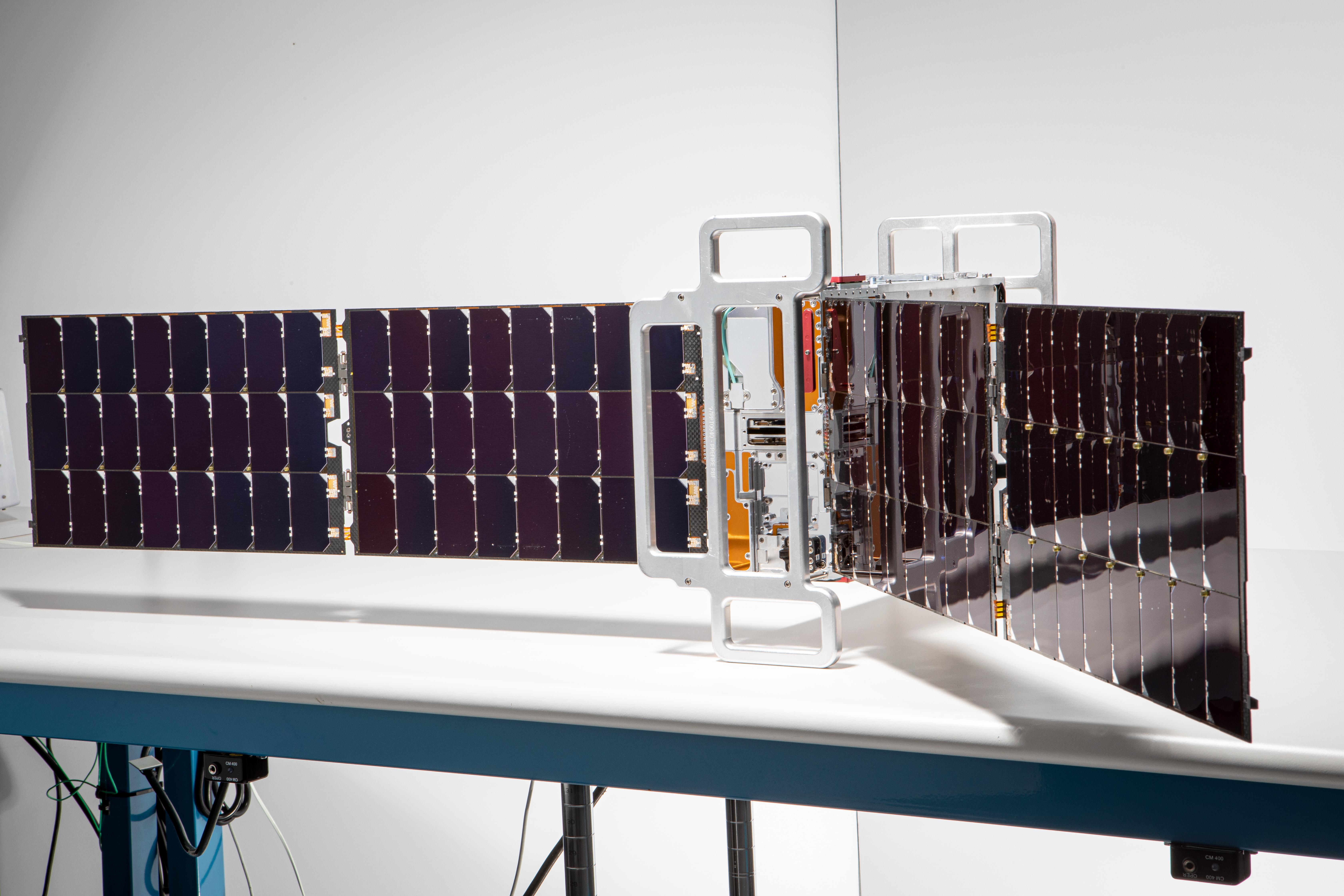
2024-05-21 |
Earth
|
Polar Radiant Energy in the Far-InfraRed Experiment (PREFIRE)
|
|
6720x4480x3 |

|
-
PIA26186:
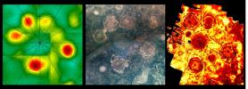
-
PREFIRE CubeSat Image
Full Resolution:
TIFF
(56.6 MB)
JPEG
(2.543 MB)
|
|
|
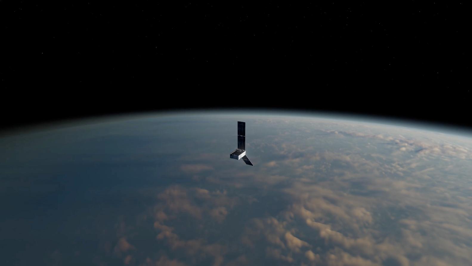
2024-05-15 |
Earth
|
Polar Radiant Energy in the Far-InfraRed Experiment (PREFIRE)
|
|
1583x891x3 |
|
-
PIA26185:
-
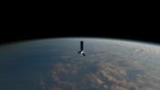
PREFIRE CubeSat in Earth Orbit (Artist's Concept)
Full Resolution:
TIFF
(1.666 MB)
JPEG
(47.7 kB)
|
|
|
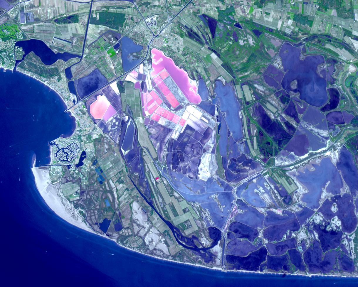
2024-05-07 |
Earth
|
SWOT
|
KaRIn
|
4000x2250x3 |
|
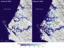
-
PIA26343:
-
SWOT Captures Flooding in Bangladesh
Full Resolution:
TIFF
(19.36 MB)
JPEG
(1.312 MB)
|
|
|
2024-04-30 |
Earth
|
Terra
|
ASTER
|
882x726x3 |
|
-
PIA26290:
-
Dinosaur Provincial Park, Canada
Full Resolution:
TIFF
(1.922 MB)
JPEG
(144.4 kB)
|
|
|
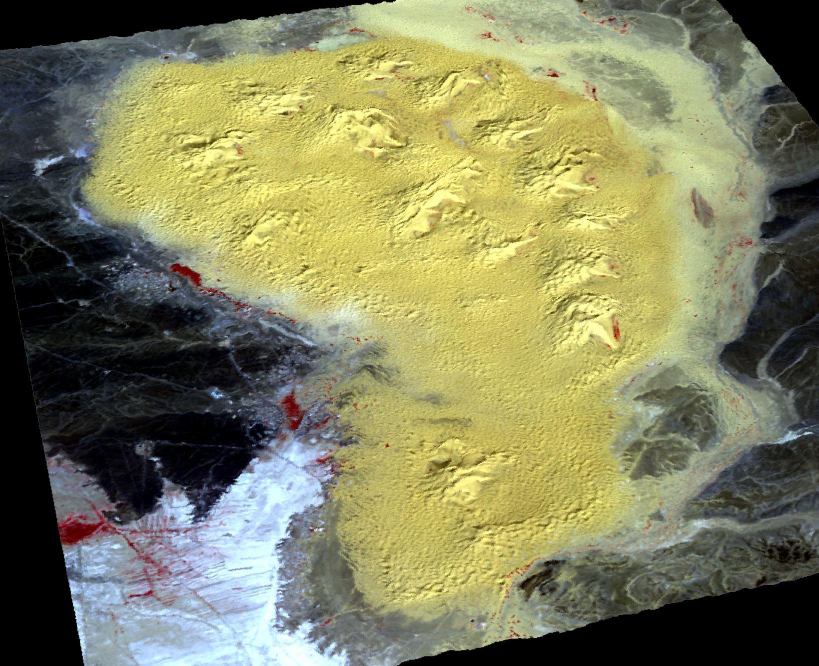
2024-04-29 |
Mars
|
Mars Reconnaissance Orbiter (MRO)
|
HiRISE
|
2880x1800x3 |
|
-
PIA26330:
-
Defrosting Dunes
Full Resolution:
TIFF
(15.56 MB)
JPEG
(896.1 kB)
|
|
|
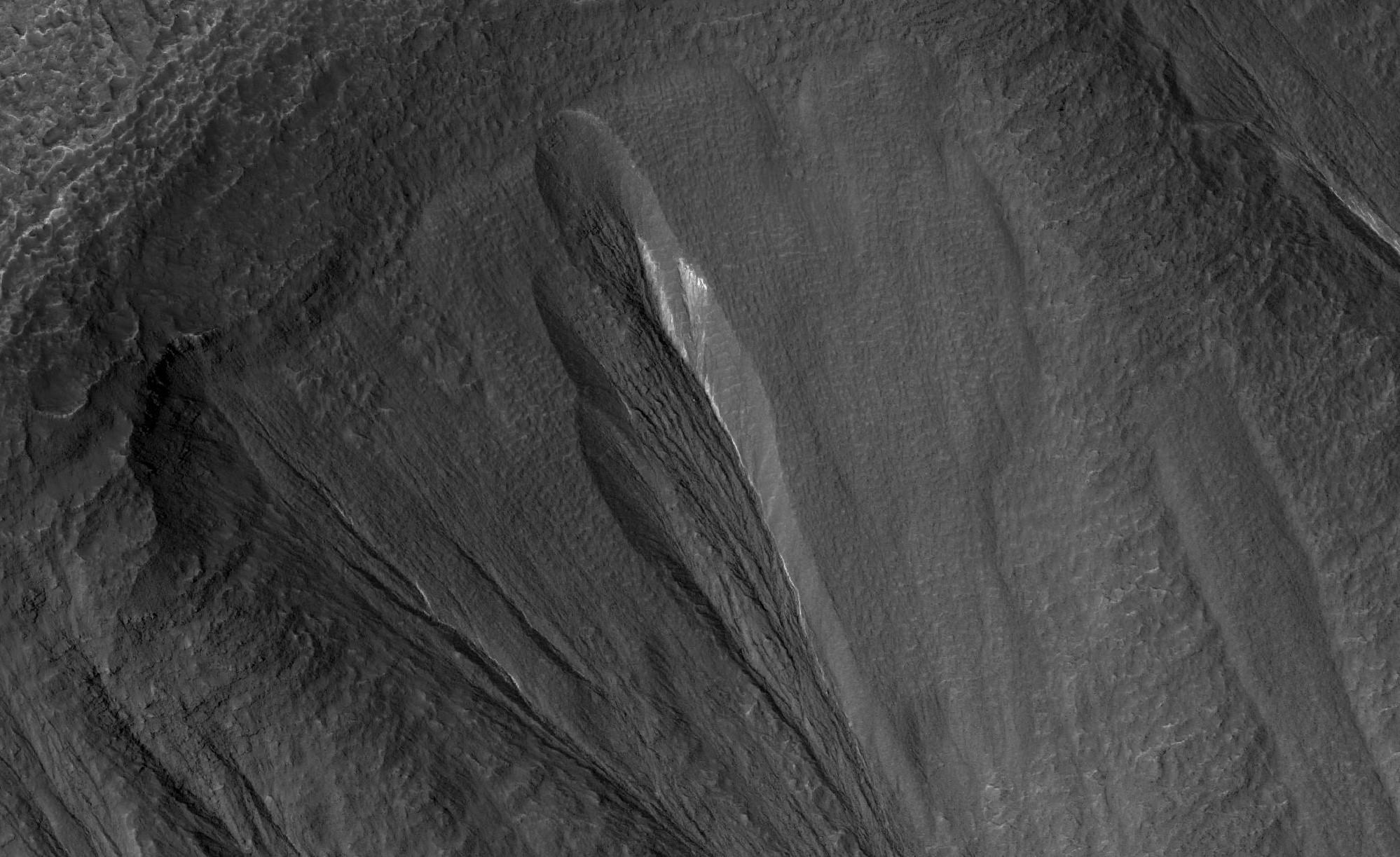
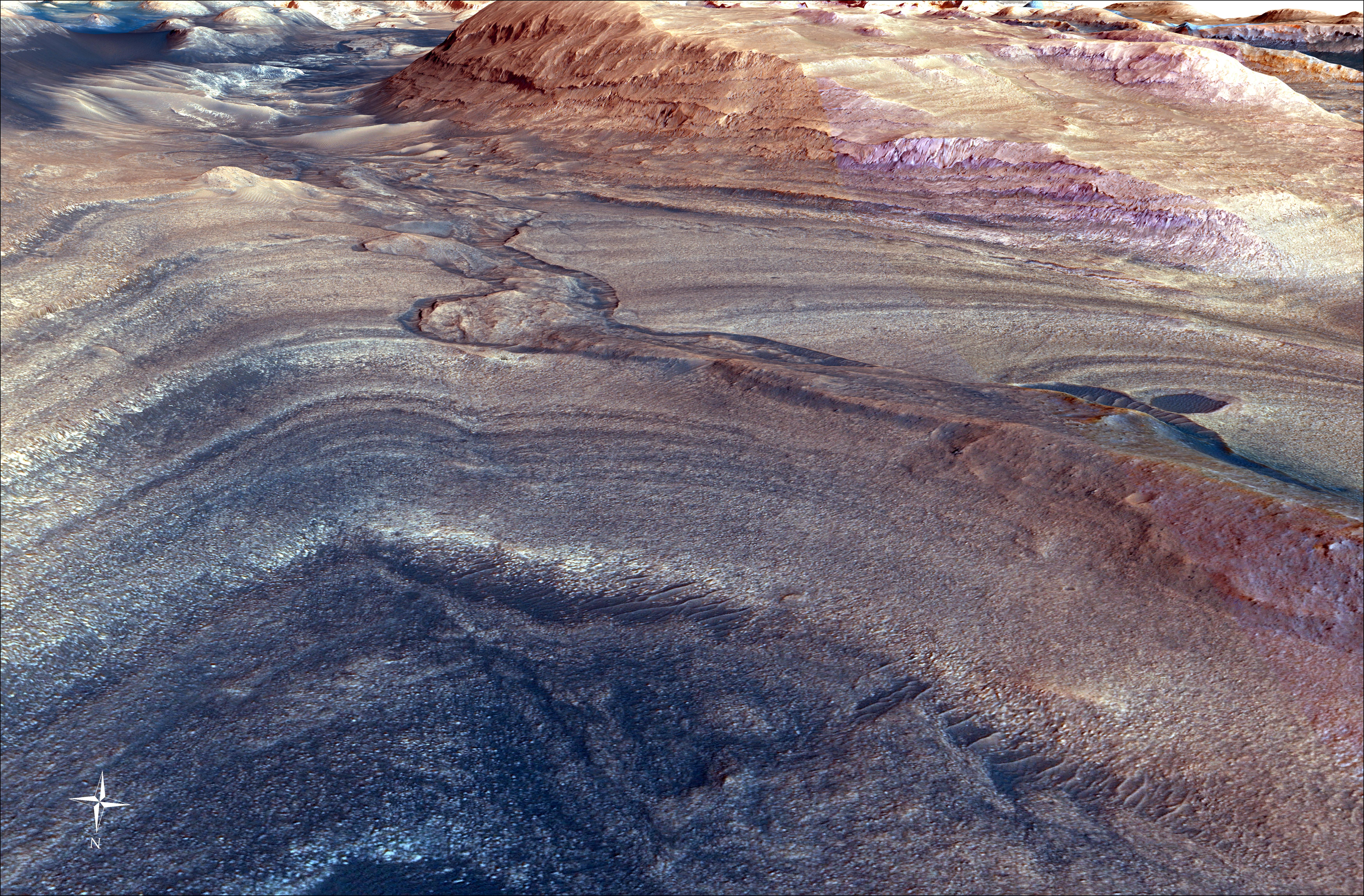
2024-04-29 |
Mars
|
Mars Reconnaissance Orbiter (MRO)
|
HiRISE
|
2880x1800x3 |
|
-
PIA26329:
-
Gullies in the Depths of Hellas
Full Resolution:
TIFF
(5.191 MB)
JPEG
(1.187 MB)
|
|
|
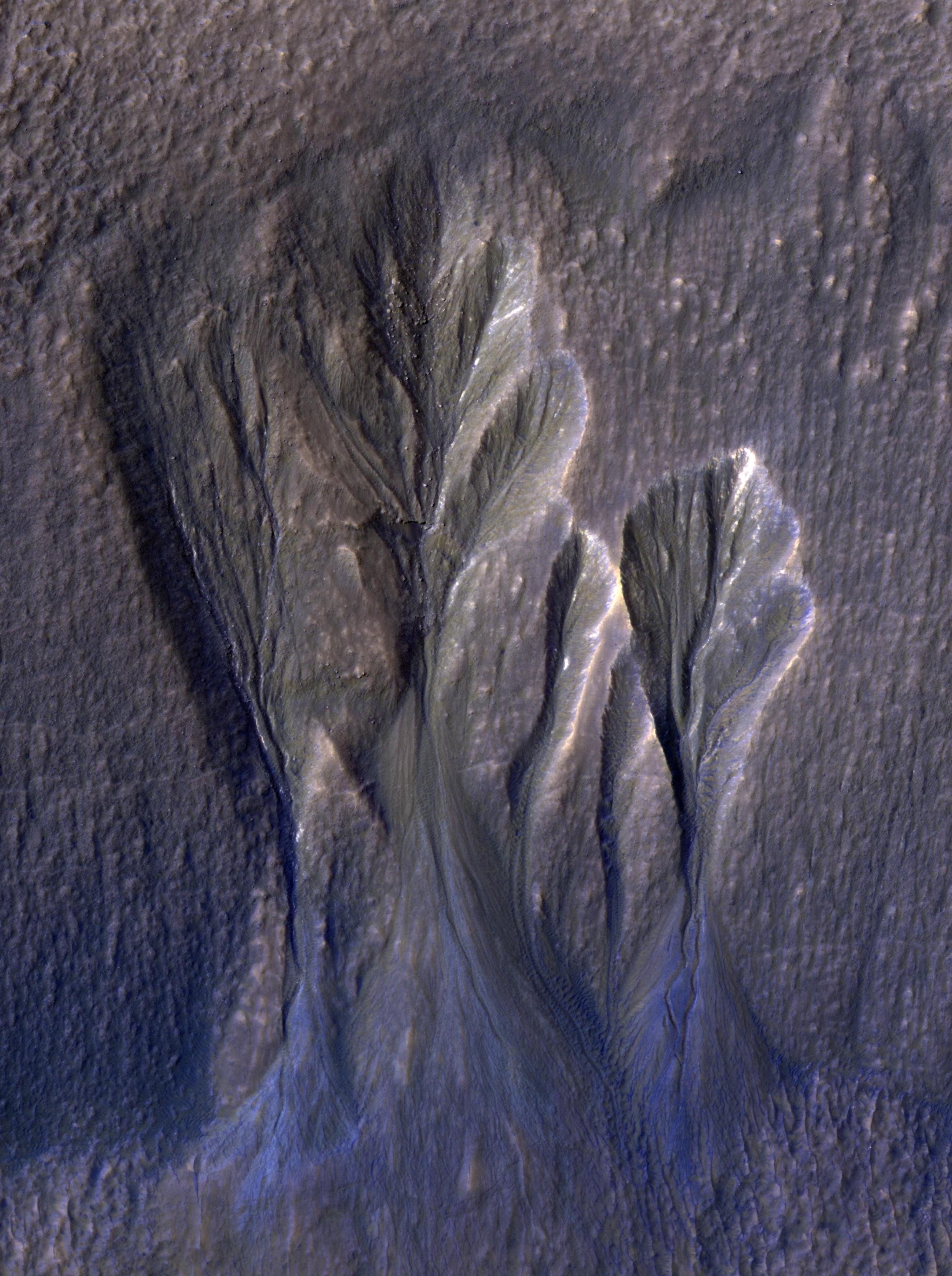
2024-04-29 |
Mars
|
Mars Reconnaissance Orbiter (MRO)
|
HiRISE
|
2880x1800x3 |
|
-
PIA26328:
-
Sediment Ponds in Tithonium Chasma
Full Resolution:
TIFF
(8.125 MB)
JPEG
(1.106 MB)
|
|
|
2024-04-29 |
Mars
|
Mars Reconnaissance Orbiter (MRO)
|
HiRISE
|
2880x1800x3 |
|
-
PIA26327:
-
Hydrated Sulfates in Melas Chasma
Full Resolution:
TIFF
(8.101 MB)
JPEG
(1.07 MB)
|
|
|
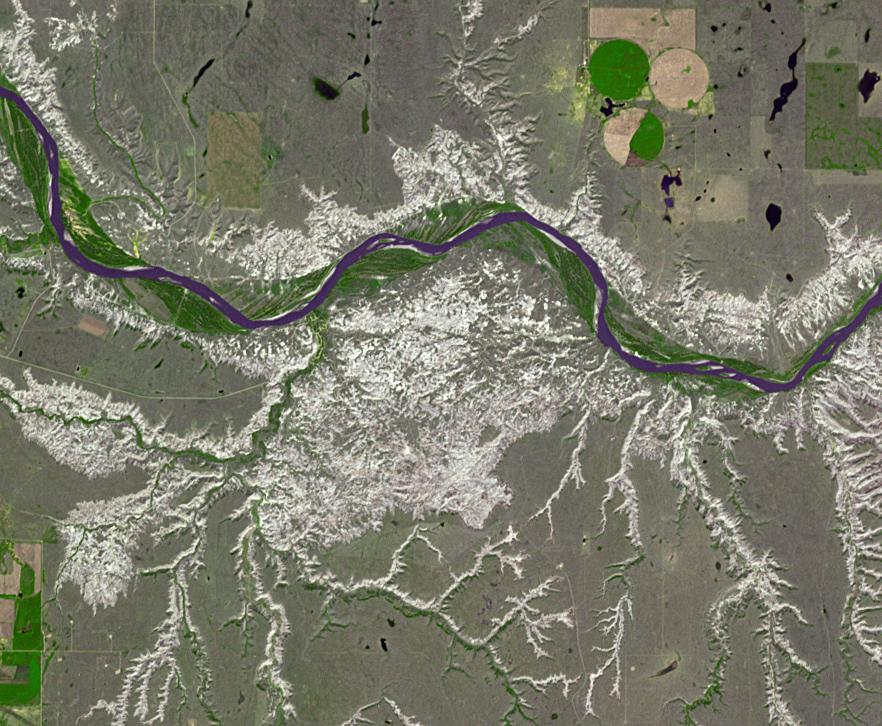
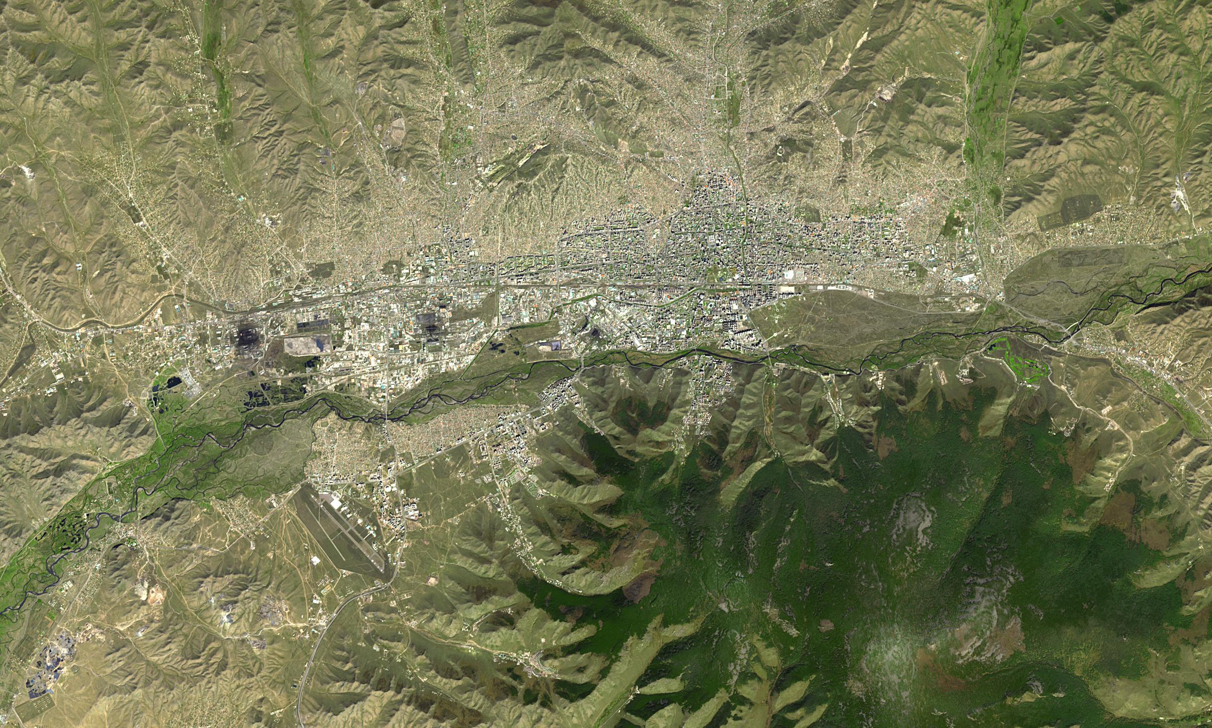
2024-04-26 |
Earth
|
Terra
|
ASTER
|
2441x1468x3 |

|
-
PIA26289:
-
Ulaanbaatar, Mongolia
Full Resolution:
TIFF
(10.75 MB)
JPEG
(854.9 kB)
|
|
|
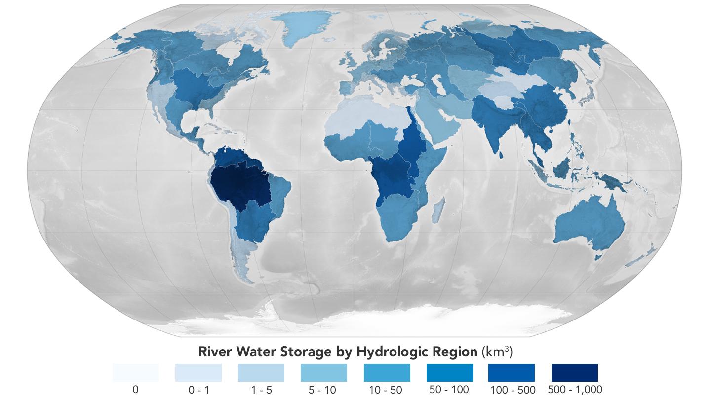
2024-04-26 |
Earth
|
|
|
1440x810x3 |
|
-
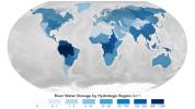
PIA26119:
-
Global Accounting of Earth's River Storage and Flow
Full Resolution:
TIFF
(1.377 MB)
JPEG
(104.8 kB)
|
|
|
2024-04-18 |
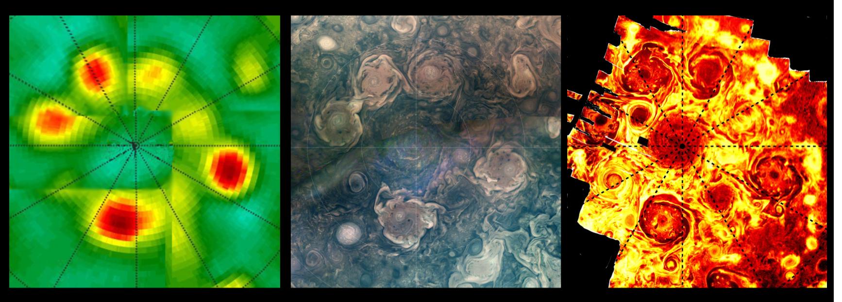
Jupiter
|
Juno
|
JunoCam
|
1734x623x3 |
|
-
PIA26295:
-
NASA's Juno Catches 3 Waves of Jupiter's Polar Cyclones
Full Resolution:
TIFF
(3.145 MB)
JPEG
(179 kB)
|
|
|
2024-04-17 |
Mars
|
Mars Helicopter
|
|
8256x5504x3 |

|
-
PIA26319:
-
Ingenuity Team's Final Shift
Full Resolution:
TIFF
(132.5 MB)
JPEG
(8.841 MB)
|
|
|
2024-04-17 |
Mars
|
Mars Helicopter
|
|
8256x5504x3 |

|
-
PIA26317:
-
Ingenuity Fist Bump
Full Resolution:
TIFF
(118.6 MB)
JPEG
(8.06 MB)
|
|
|
2024-04-17 |
Mars
|
Mars Helicopter
|
|
8256x5504x3 |

|
-
PIA26316:
-
Ingenuity Project Manager Says Goodbye
Full Resolution:
TIFF
(99.36 MB)
JPEG
(6.555 MB)
|
|
|
2024-04-17 |
Mars
|
Mars Helicopter
|
|
8256x5504x3 |

|
-
PIA26315:
-
Ingenuity Team Lead All Smiles
Full Resolution:
TIFF
(126.8 MB)
JPEG
(8.698 MB)
|
|
|
2024-04-16 |
Mars
|
Mars Helicopter
|
|
8256x5504x3 |

|
-
PIA26318:
-
Mars Helicopter Team Witnesses Final Downlink
Full Resolution:
TIFF
(119 MB)
JPEG
(8.659 MB)
|
|
|
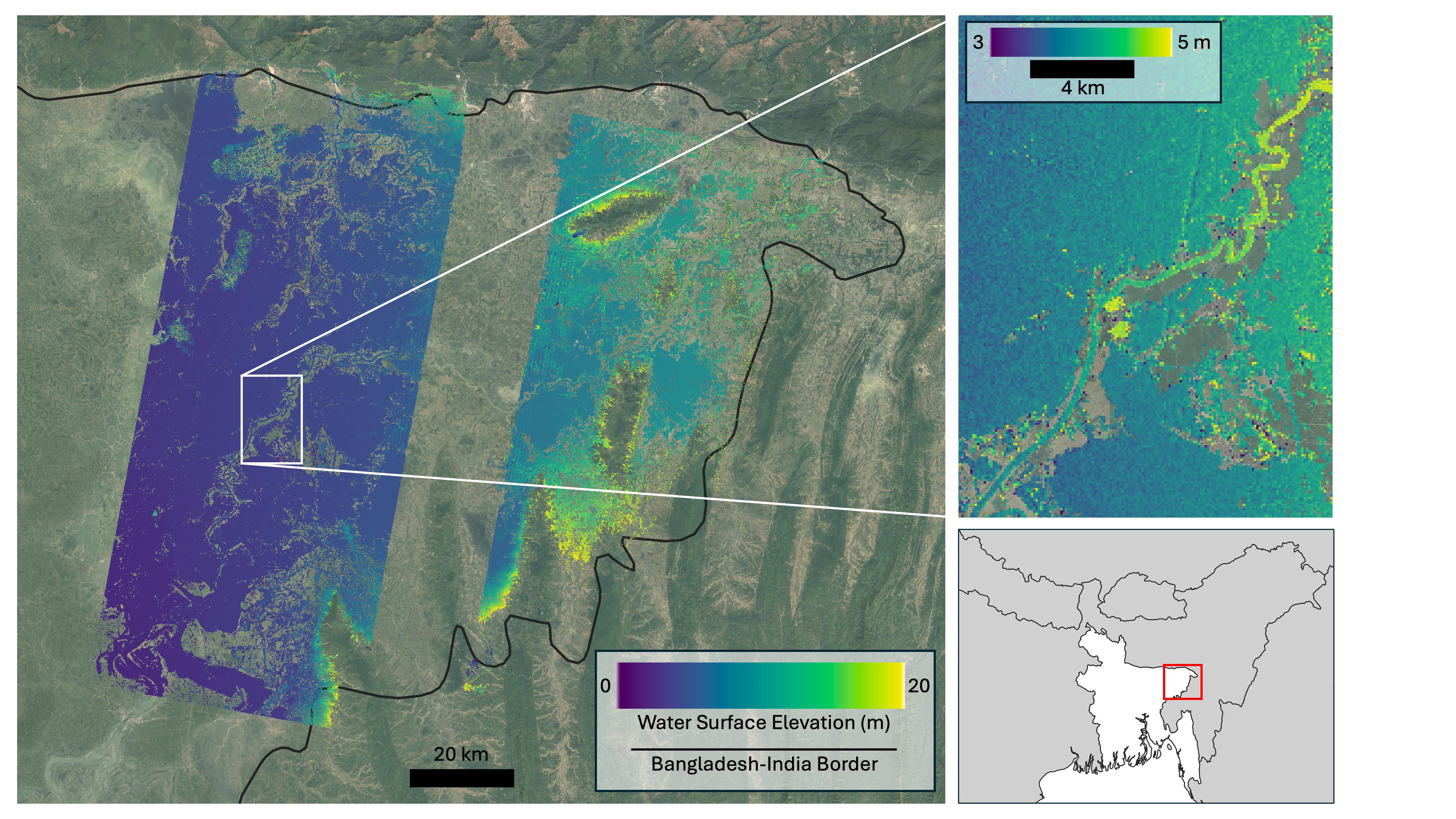
2024-04-15 |
Earth
|
SWOT
|
KaRIn
|
1440x1090x3 |
|
-
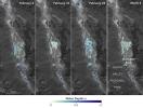
PIA26184:
-
SWOT Death Valley Lake Depth
Full Resolution:
TIFF
(2.295 MB)
JPEG
(265.3 kB)
|
|
|
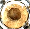
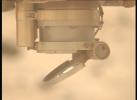
2024-04-03 |
Mars
|
Mars 2020 Rover
|
Hazard Avoidance Camera (M2020)
|
838x517x3 |
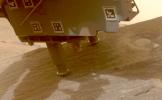
|
-
PIA26314:
-
Perseverance Cores 'Bunsen Peak'
Full Resolution:
TIFF
(825.3 kB)
JPEG
(51.66 kB)
|
|
|
2024-04-03 |
Mars
|
Mars 2020 Rover
|
|
1100x1100x3 |
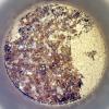
|
-
PIA26313:
-
Perseverance's 'Bunsen Peak' Sample
Full Resolution:
TIFF
(3.631 MB)
JPEG
(261.1 kB)
|
|
|
2024-04-03 |
Mars
|
Mars 2020 Rover
|
Mastcam-Z
|
4524x3334x3 |
|
-
PIA26312:
-
Perseverance's View of 'Bunsen Peak'
Full Resolution:
TIFF
(27.75 MB)
JPEG
(1.119 MB)
|
|
|
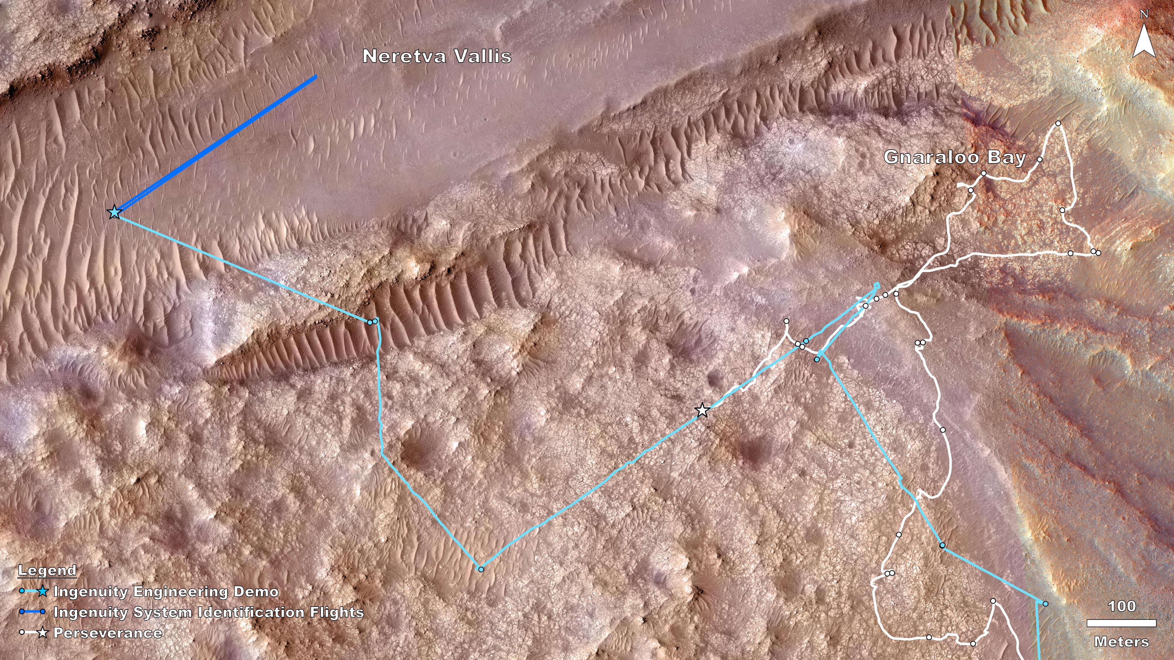
2024-03-29 |
Mars
|
Mars Helicopter
|
|
4000x2250x3 |
|
-
PIA26311:
-
Rover, Helicopter Locations in Jezero Crater
Full Resolution:
TIFF
(27.01 MB)
JPEG
(1.883 MB)
|
|
|
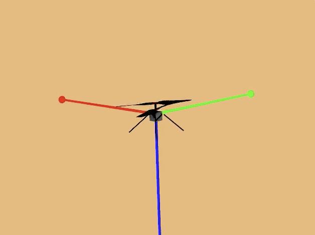
2024-03-29 |
Mars
|
Mars Helicopter
|
|
628x469x3 |
|
-
PIA26240:
-
Animation of Mars Helicopter Flight Test
Full Resolution:
TIFF
(104.3 kB)
JPEG
(9.195 kB)
|
|
|
2024-03-29 |
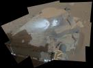
Mars
|
Mars Science Laboratory (MSL)
|
Navcam (MSL)
|
5759x5759x1 |
|
-
PIA26310:
-
Curiosity Takes a Navcam Selfie
Full Resolution:
TIFF
(18.79 MB)
JPEG
(2.288 MB)
|
|
|
2024-03-29 |
Mars
|
Mars Science Laboratory (MSL)
|
Navcam (MSL)
|
3432x1503x1 |
|
-
PIA26247:
-
Curiosity Looks Back Down the Slope
Full Resolution:
TIFF
(3.619 MB)
JPEG
(569.4 kB)
|
|
|
2024-03-29 |
Mars
|
Mars Science Laboratory (MSL)
|
Navcam (MSL)
|
7696x2774x1 |
|
-
PIA26246:
-
Curiosity Arrives at Gediz Vallis Channel
Full Resolution:
TIFF
(14.07 MB)
JPEG
(2.033 MB)
|
|
|
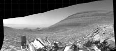
2024-03-29 |
Mars
|
Mars Reconnaissance Orbiter (MRO)
|
HiRISE
|
7003x4603x3 |

|
-
PIA26241:
-
Curiosity's Route to Gediz Vallis Channel (Rendering)
Full Resolution:
TIFF
(96.74 MB)
JPEG
(5.638 MB)
|
|
|
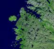
2024-03-29 |
Earth
|
Terra
|
ASTER
|
800x600x3 |
|
-
PIA26288:
-
March 2024 Iceland Eruption
Full Resolution:
TIFF
(958.1 kB)
JPEG
(31.88 kB)
|
|
|
2024-03-26 |
Earth
|
Terra
|
ASTER
|
1639x1333x3 |

|
-
PIA26287:
-
Star Dunes, Morocco
Full Resolution:
TIFF
(6.557 MB)
JPEG
(367.1 kB)
|
|
|
2024-03-26 |
Mars
|
Mars Reconnaissance Orbiter (MRO)
|
HiRISE
|
2880x1800x3 |
|
-
PIA26324:
-
Searching for Distant Secondary Craters
Full Resolution:
TIFF
(15.56 MB)
JPEG
(1.134 MB)
|
|
|
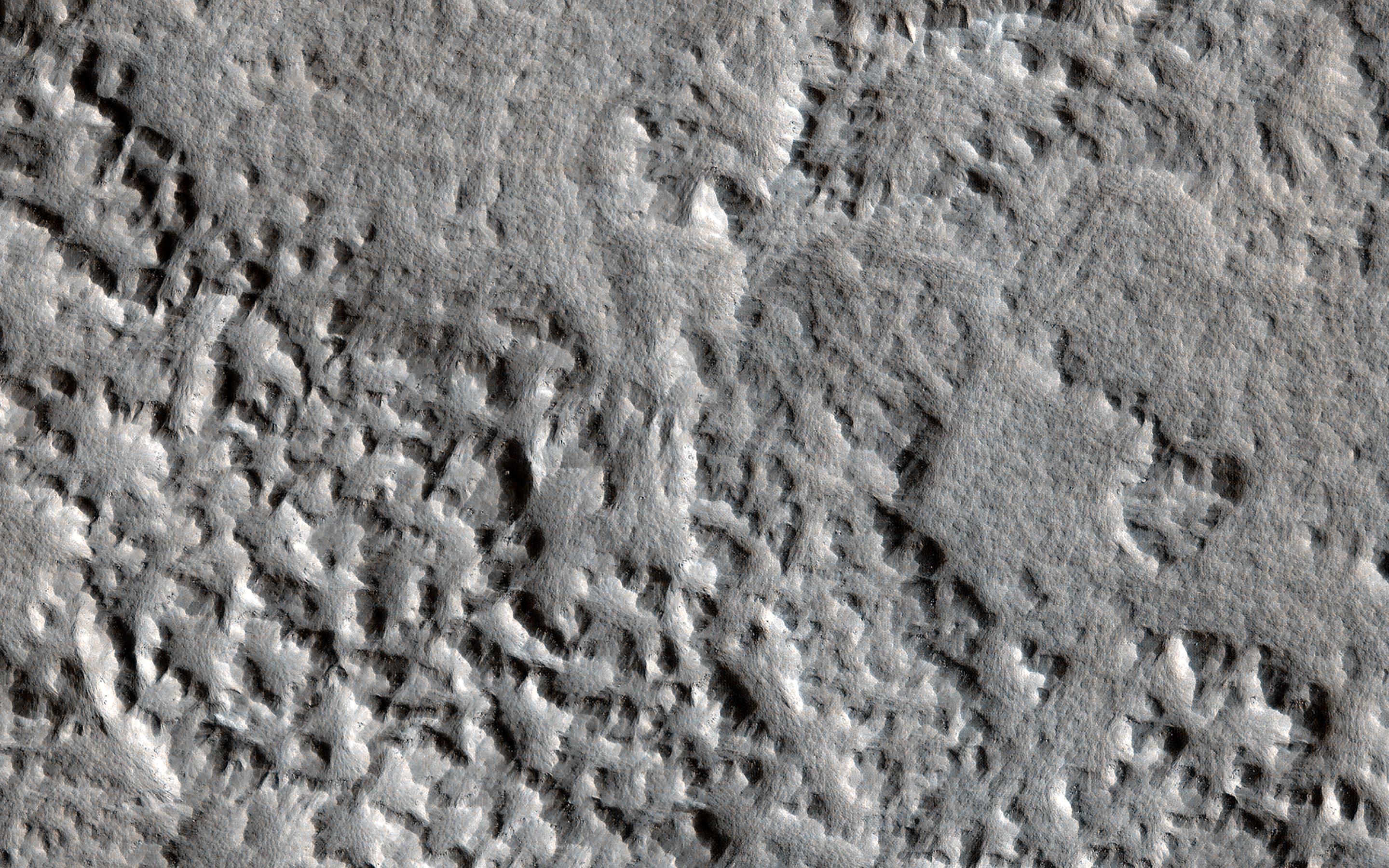
2024-03-26 |
Mars
|
Mars Reconnaissance Orbiter (MRO)
|
HiRISE
|
2880x1800x3 |
|
-
PIA26323:
-
A Song of Ice and Tectonics
Full Resolution:
TIFF
(15.56 MB)
JPEG
(638.8 kB)
|
|
|
2024-03-26 |
Mars
|
Mars Reconnaissance Orbiter (MRO)
|
HiRISE
|
2880x1800x3 |
|
-
PIA26322:
-
Mars Atmosphere Fights Back!
Full Resolution:
TIFF
(13.22 MB)
JPEG
(711.7 kB)
|
|
|
2024-03-26 |
Mars
|
Mars Reconnaissance Orbiter (MRO)
|
HiRISE
|
2880x1800x3 |
|
-
PIA26321:
-
Mars Mysteries: Unveiling the Icy Craters
Full Resolution:
TIFF
(12.88 MB)
JPEG
(730.7 kB)
|
|
|
2024-03-21 |
Earth
|
TOPEX/Poseidon
Sentinel-6 Michael Freilich
|
|
3300x2550x3 |

|
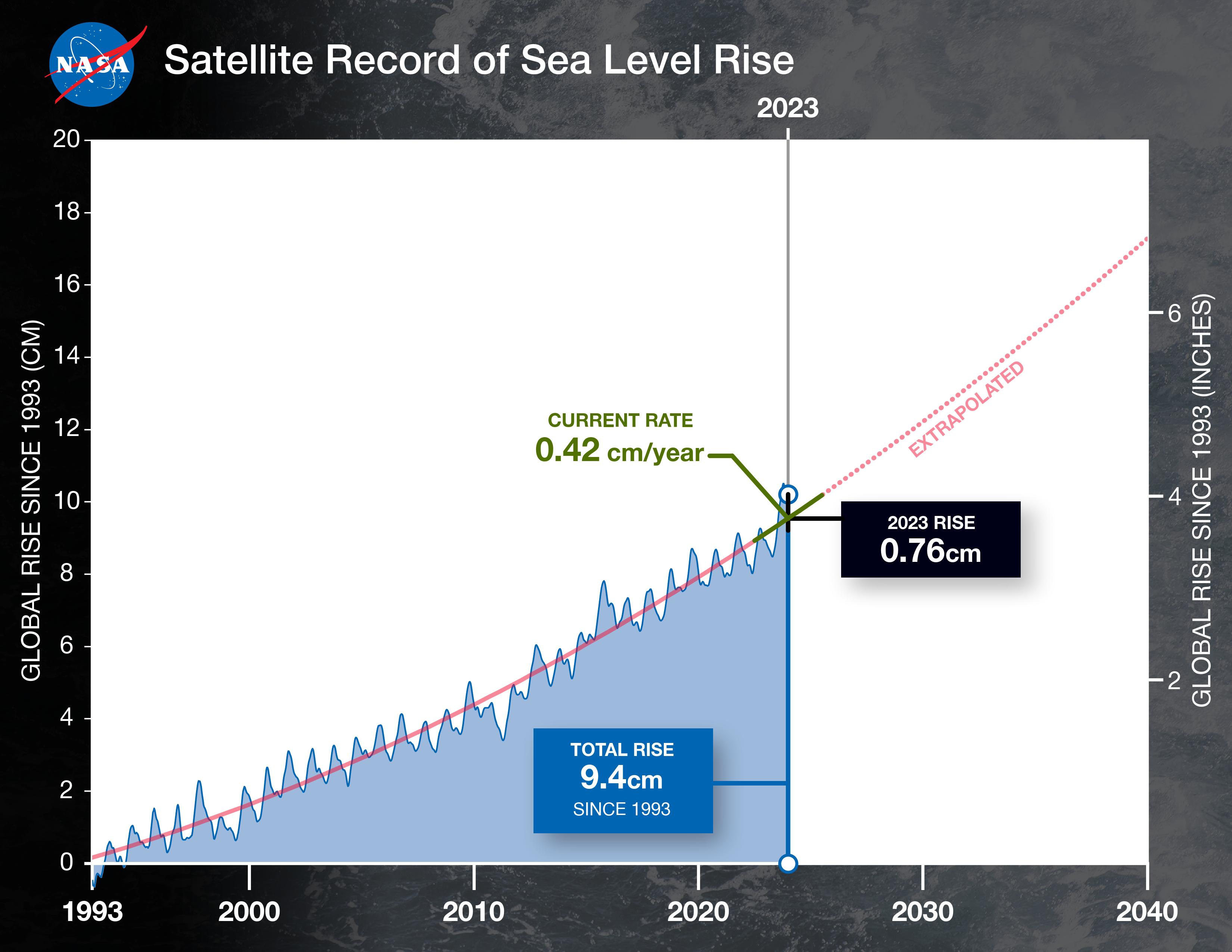
-
PIA26183:
-
2023 Sea Level Rise Update
Full Resolution:
TIFF
(5.199 MB)
JPEG
(459.8 kB)
|
|
|
2024-03-21 |
Earth
|
Terra
|
ASTER
|
1578x1514x3 |

|
-
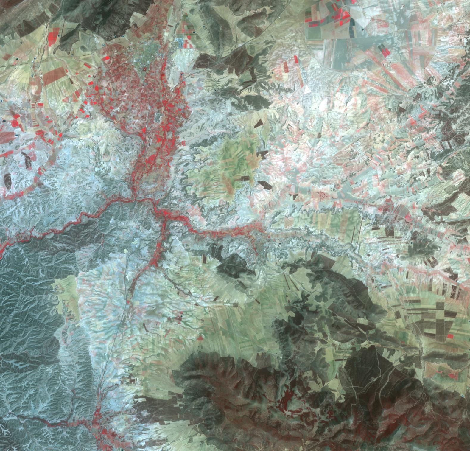
PIA26286:
-
Orce, Spain
Full Resolution:
TIFF
(7.17 MB)
JPEG
(425.4 kB)
|
|
|
2024-03-05 |
Mercury
|
Mars 2020 Rover
|
Mastcam-Z
|
200x296x3 |
|
-
PIA26250:
-
Perseverance Views a Transit of Mercury
Full Resolution:
TIFF
(98.58 kB)
JPEG
(5.215 kB)
|
|
|
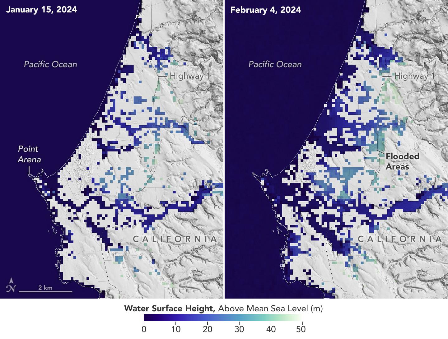
2024-03-05 |
Earth
|
SWOT
|
KaRIn
|
1440x1090x3 |
|
-
PIA26182:
-
California Coastal Flooding Captured in SWOT Data
Full Resolution:
TIFF
(2.527 MB)
JPEG
(255.1 kB)
|
|
|
2024-02-29 |
Mars
|
Mars Reconnaissance Orbiter (MRO)
|
HiRISE
|
1013x804x3 |
|
-
PIA26245:
-
HiRISE Spots Curiosity Driving Toward Upper Gediz Vallis
Full Resolution:
TIFF
(2.444 MB)
JPEG
(132.2 kB)
|
|
|
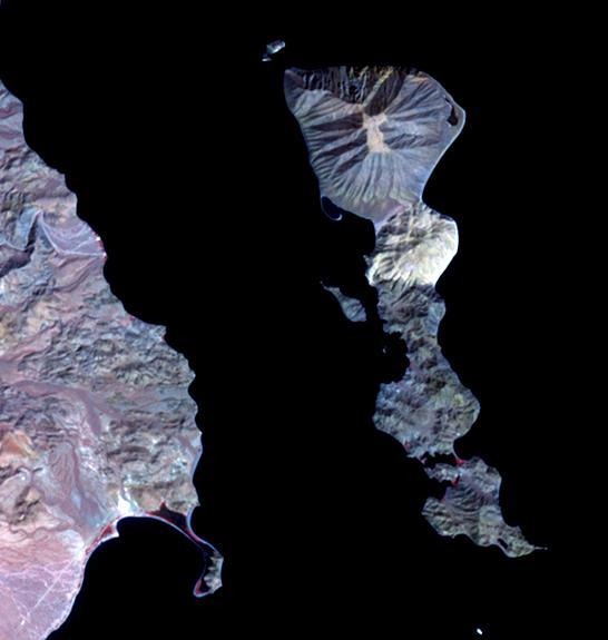
2024-02-27 |
Earth
|
Terra
|
ASTER
|
546x575x3 |
|
-
PIA26284:
-
Smith Island, Gulf of California
Full Resolution:
TIFF
(393.5 kB)
JPEG
(29.75 kB)
|
|
|
2024-02-27 |
Mars
|
Mars Helicopter
|
|
640x480x1 |
|
-
PIA26244:
-
Ingenuity's Navcam Reveals a Missing Rotor Blade
Full Resolution:
TIFF
(176.6 kB)
JPEG
(36.83 kB)
|
|
|
2024-02-27 |
Mars
|
Mars 2020 Rover
|
SuperCam
|
7371x2284x3 |
|
-
PIA26238:
-
SuperCam's RMI Spots Ingenuity's Broken Rotor
Full Resolution:
TIFF
(23.33 MB)
JPEG
(897.8 kB)
|
|
|
2024-02-27 |
Mars
|
Mars 2020 Rover
|
Mastcam-Z
|
24346x5500x3 |

|
-
PIA26237:
Ingenuity at 'Valinor Hills'
Full Resolution:
TIFF
(257.5 MB)
JPEG
(11.04 MB)
|
|
|
2024-02-26 |
Asteroid
|
Deep Space Network (DSN)
|
Deep Space Network
|
3410x2222x1 |
|
-
PIA26149:
-
NASA's Planetary Radar Images Slow-Spinning Asteroid 2008 OS7
Full Resolution:
TIFF
(1.567 MB)
JPEG
(725.4 kB)
|
|
|
2024-02-15 |
Earth
|
Terra
|
ASTER
|
2016x1184x3 |
|
-
PIA26283:
-
Grindavik, Iceland Eruption
Full Resolution:
TIFF
(3.026 MB)
JPEG
(243.4 kB)
|
 Planetary Data System


