PDS logoPlanetary Data System
PDS Information
Find a Node - Use these links to navigate to any of the 8 publicly accessible PDS Nodes.

This bar indicates that you are within the PDS enterprise which includes 6 science discipline nodes and 2 support nodes which are overseen by the Project Management Office at NASA's Goddard Space Flight Center (GSFC). Each node is led by an expert in the subject discipline, supported by an advisory group of other practitioners of that discipline, and subject to selection and approval under a regular NASA Research Announcement.
Click here to return to the Photojournal Home Page Click here to view a list of Photojournal Image Galleries Photojournal_inner_header
Latest Images  |  Spacecraft & Technology  |  Animations  |  Space Images App  |  Feedback  |  Photojournal Search  

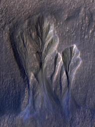
PIA26407: Dusty Water Ice in Mars' Terra Sirenum
 Target Name:  Mars
 Is a satellite of:  Sol (our sun)
 Mission:  Mars Reconnaissance Orbiter (MRO)
 Spacecraft:  Mars Reconnaissance Orbiter (MRO)
 Instrument:  HiRISE
 Product Size:  3232 x 4333 pixels (w x h)
 Produced By:  University of Arizona
 Full-Res TIFF:  PIA26407.tif (41.04 MB)
 Full-Res JPEG:  PIA26407.jpg (1.397 MB)

Click on the image above to download a moderately sized image in JPEG format (possibly reduced in size from original)

Original Caption Released with Image:

This image from NASA's Mars Reconnaissance Orbiter (MRO) shows white material believed to be dusty water ice lining the edges of Martian gullies in a region named Terra Sirenum. Scientists believe dust particles within this ice act similarly to dust that falls onto glaciers on Earth, warming up in sunlight and causing subsurface pockets of meltwater to form.

On Earth, the dust that builds up on glaciers is called cryoconite, and the pockets it forms are called cryoconite holes. These pockets of water on our planet are often teeming with simple life, including algae, fungi, and cyanobacteria. Scientists believe similar shallow pools of water could exist on Mars, and may also be excellent places to search for life on the Red Planet today.

This enhanced-color image was captured by MRO's HiRISE (High-Resolution Imaging Science Experiment) camera on Dec. 25, 2016.

The blue color at the bottom of the gullies is likely coarse sand (not ice); the hue would not actually be perceptible to the human eye. HiRISE is able to detect this color by looking at the scene in far-infrared wavelengths.

The University of Arizona, in Tucson, operates HiRISE, which was built by Ball Aerospace & Technologies Corp., in Boulder, Colorado. NASA's Jet Propulsion Laboratory, a division of Caltech in Pasadena, California, manages the Mars Reconnaissance Orbiter Project for NASA's Science Mission Directorate in Washington.

For more information, visit: science.nasa.gov/mission/mars-reconnaissance-orbiter

Image Credit:
NASA/JPL-Caltech/University of Arizona

Image Addition Date:
2024-10-10