PDS logoPlanetary Data System
PDS Information
Find a Node - Use these links to navigate to any of the 8 publicly accessible PDS Nodes.

This bar indicates that you are within the PDS enterprise which includes 6 science discipline nodes and 2 support nodes which are overseen by the Project Management Office at NASA's Goddard Space Flight Center (GSFC). Each node is led by an expert in the subject discipline, supported by an advisory group of other practitioners of that discipline, and subject to selection and approval under a regular NASA Research Announcement.
Click here to return to the Photojournal Home Page Click here to view a list of Photojournal Image Galleries Photojournal_inner_header
Latest Images  |  Spacecraft & Technology  |  Animations  |  Space Images App  |  Feedback  |  Photojournal Search  

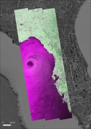
PIA26414: NASA's OPERA Project Generates Radar Image of Hurricane Helene
 Target Name:  Earth
 Is a satellite of:  Sol (our sun)
 Spacecraft:  Copernicus Sentinel-1A
 Instrument:  SAR 
 Product Size:  2480 x 3507 pixels (w x h)
 Produced By:  JPL
 Full-Res TIFF:  PIA26414.tif (18.81 MB)
 Full-Res JPEG:  PIA26414.jpg (2.337 MB)

Click on the image above to download a moderately sized image in JPEG format (possibly reduced in size from original)

Original Caption Released with Image:

NASA's Observational Products for End-Users from Remote Sensing Analysis (OPERA) project generated a radar image of Hurricane Helene on Friday, Sept. 26, 2024, at 7:38 p.m. local time, as the storm approached the Florida coast. One of the largest storms to develop in the Gulf of Mexico in the last century, Helene made landfall as a Category 4 hurricane in the Big Bend area of Florida at about 11:10 p.m.

The data shown in the image is from the synthetic aperture radar (SAR) instrument on the Copernicus Sentinel-1A satellite, operated by the European Space Agency (ESA), and processed by OPERA into a data product called OPERA RTC-S1. The OPERA RTC-S1 image was converted to a false color image. In this color scale, vegetated areas appear green, urban areas appear white/pink, calm water appears black, and rough water appears purple or magenta. The eye of the hurricane can be clearly seen as a large dark patch in the Gulf of Mexico. The OPERA RTC-S1 image was superimposed on a Google Earth satellite background shown in grayscale and the ESRI Boundaries Places layer.

The OPERA project, managed by NASA's Jet Propulsion Laboratory in Southern California and funded by the U.S. Group on Earth Observation's Satellite Needs Working Group, creates remote sensing products to address Earth observation needs across U.S. civilian federal agencies.

The image contains modified Copernicus Sentinel data processed by ESA, Google Earth Satellite Imagery, and OPERA RTC-S1 imagery.

More information about OPERA can be found at https://www.jpl.nasa.gov/go/opera/.

Image Credit:
NASA/JPL-Caltech and ESA

Image Addition Date:
2024-10-02