My
List |
Addition Date
|
Target
|
Mission
|
Instrument
|
Size
|

|
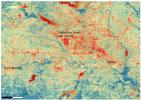
2024-11-14 |
Earth
|
Earth Surface Mineral Dust Source Investigation (EMIT)
|
EMIT
|
1771x1179x3 |
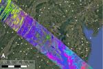
|
-
PIA26418:
-
NASA's EMIT Collects Data on Mid-Atlanic Plant Communities
Full Resolution:
TIFF
(6.267 MB)
JPEG
(631.5 kB)
|
|
|
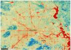
2024-11-14 |
Earth
|
Earth Surface Mineral Dust Source Investigation (EMIT)
|
EMIT
|
1942x1356x3 |
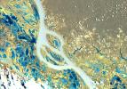
|
-
PIA26417:
-
NASA's EMIT Scans the Amazon River in Northern Brazil
Full Resolution:
TIFF
(7.903 MB)
JPEG
(575.4 kB)
|
|
|
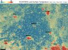
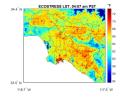
2024-09-13 |
Earth
|
ECOSTRESS
|
|
3507x2480x3 |
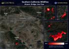
|
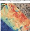
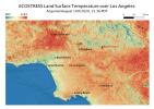
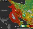
-
PIA26187:
-
Southern California Wildfires Captured by NASA's ECOSTRESS
Full Resolution:
TIFF
(19.8 MB)
JPEG
(1.341 MB)
|
|
|
2024-07-02 |
Earth
|
ECOSTRESS
|
ECOSTRESS
|
5846x4133x3 |
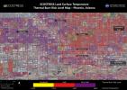
|
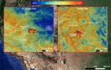
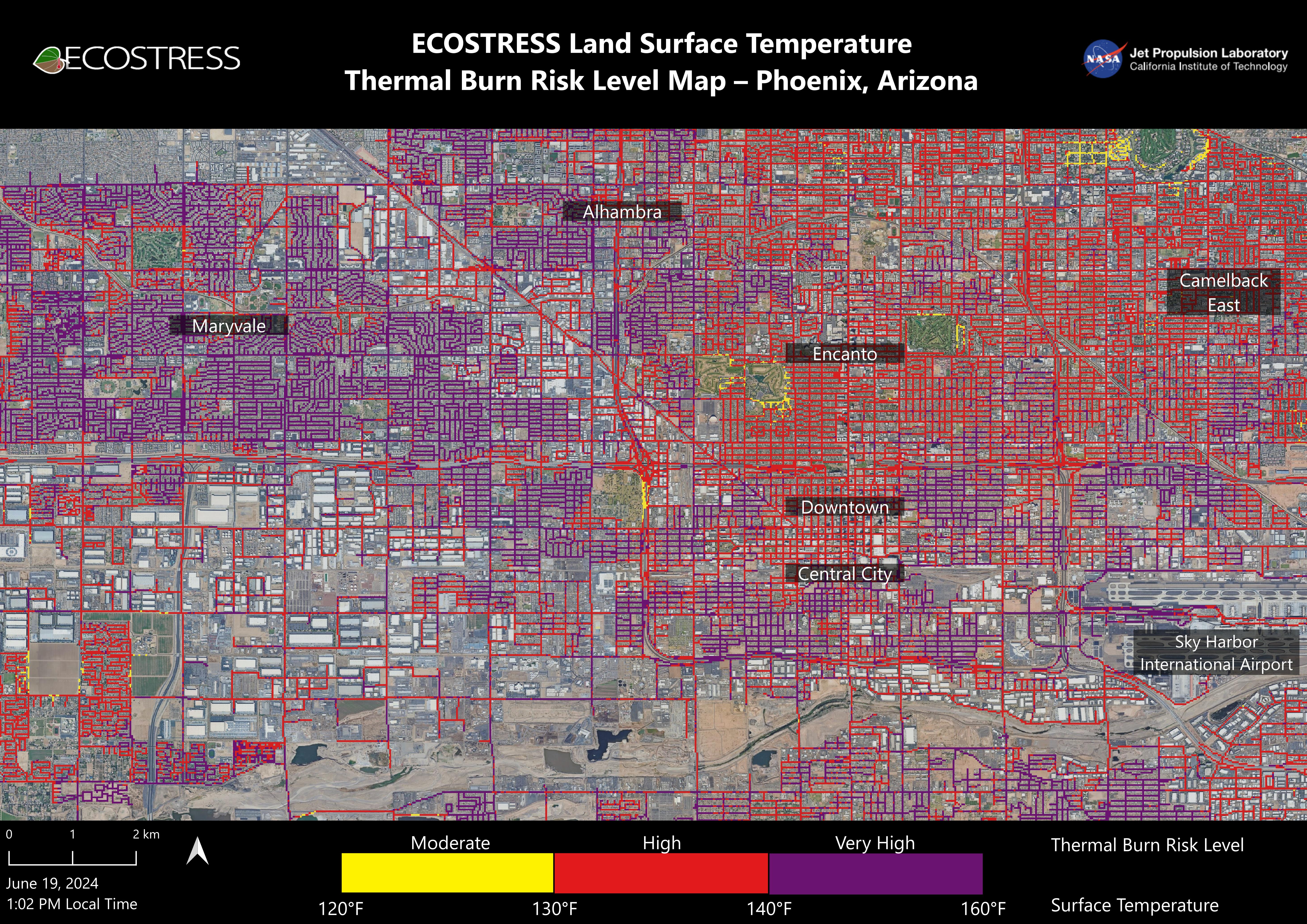
-
PIA25529:
-
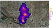
NASA's ECOSTRESS Maps Burn Risk Across Phoenix Streets
Full Resolution:
TIFF
(56.15 MB)
JPEG
(5.17 MB)
|
|
|
2023-12-11 |
Earth
|
Earth Surface Mineral Dust Source Investigation (EMIT)
|
EMIT
|
5836x2174x3 |
|
-
PIA26116:
-
NASA's EMIT Mission Produces Maps of Arid Region Surface Minerals
Full Resolution:
TIFF
(21.27 MB)
JPEG
(819.1 kB)
|
|
|
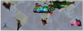
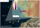
2023-11-17 |
Earth
|
Earth Surface Mineral Dust Source Investigation (EMIT)
|
EMIT
|
3499x1700x3 |
|
-
PIA26113:
-
EMIT Identifying Methane Plumes Around the Globe
Full Resolution:
TIFF
(17.85 MB)
JPEG
(1.131 MB)
|
|
|
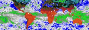
2023-08-29 |
Earth
|
COWVR
|
COWVR
TEMPEST
|
1606x1527x3 |

|
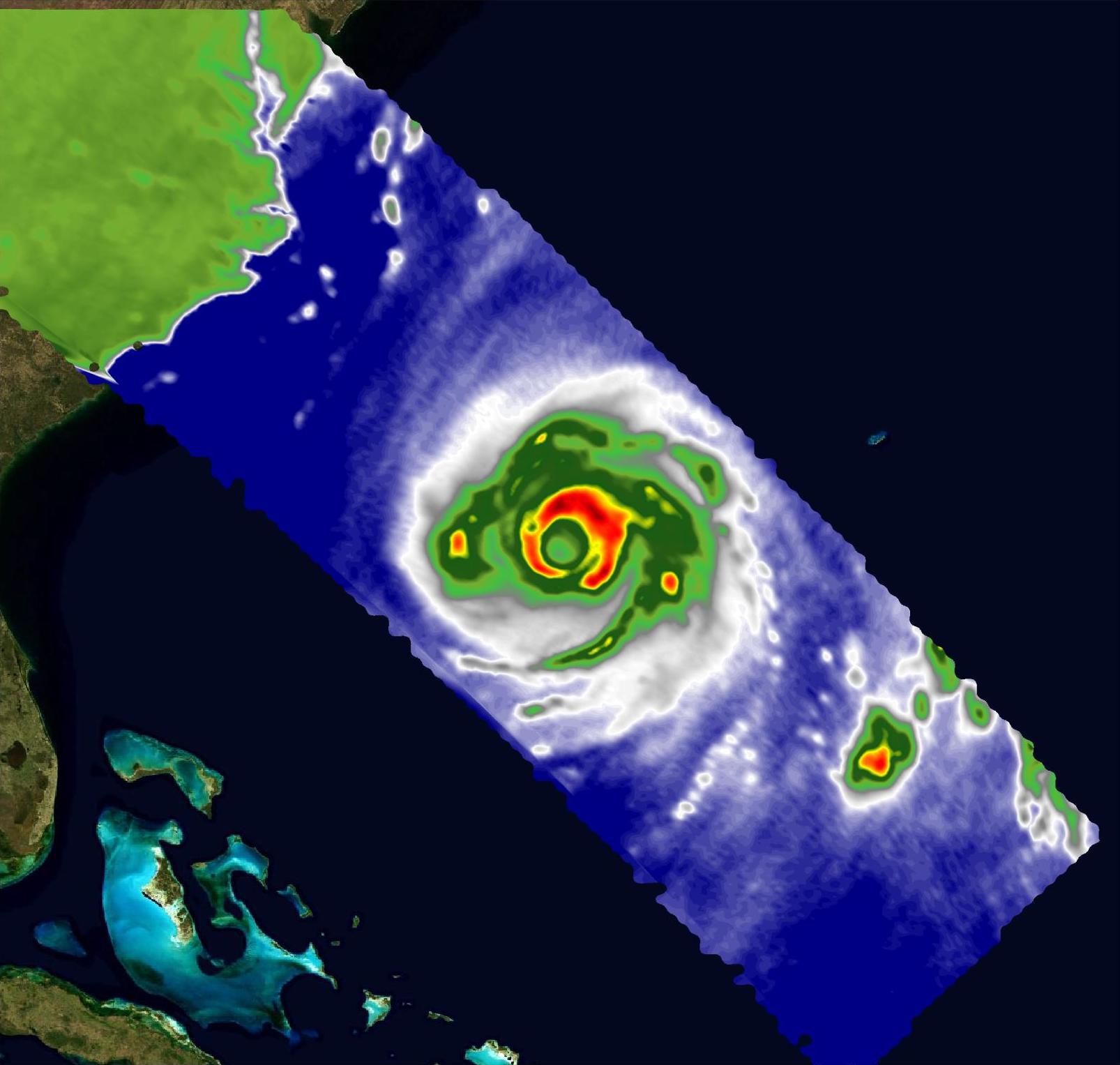
-
PIA25870:
-
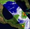
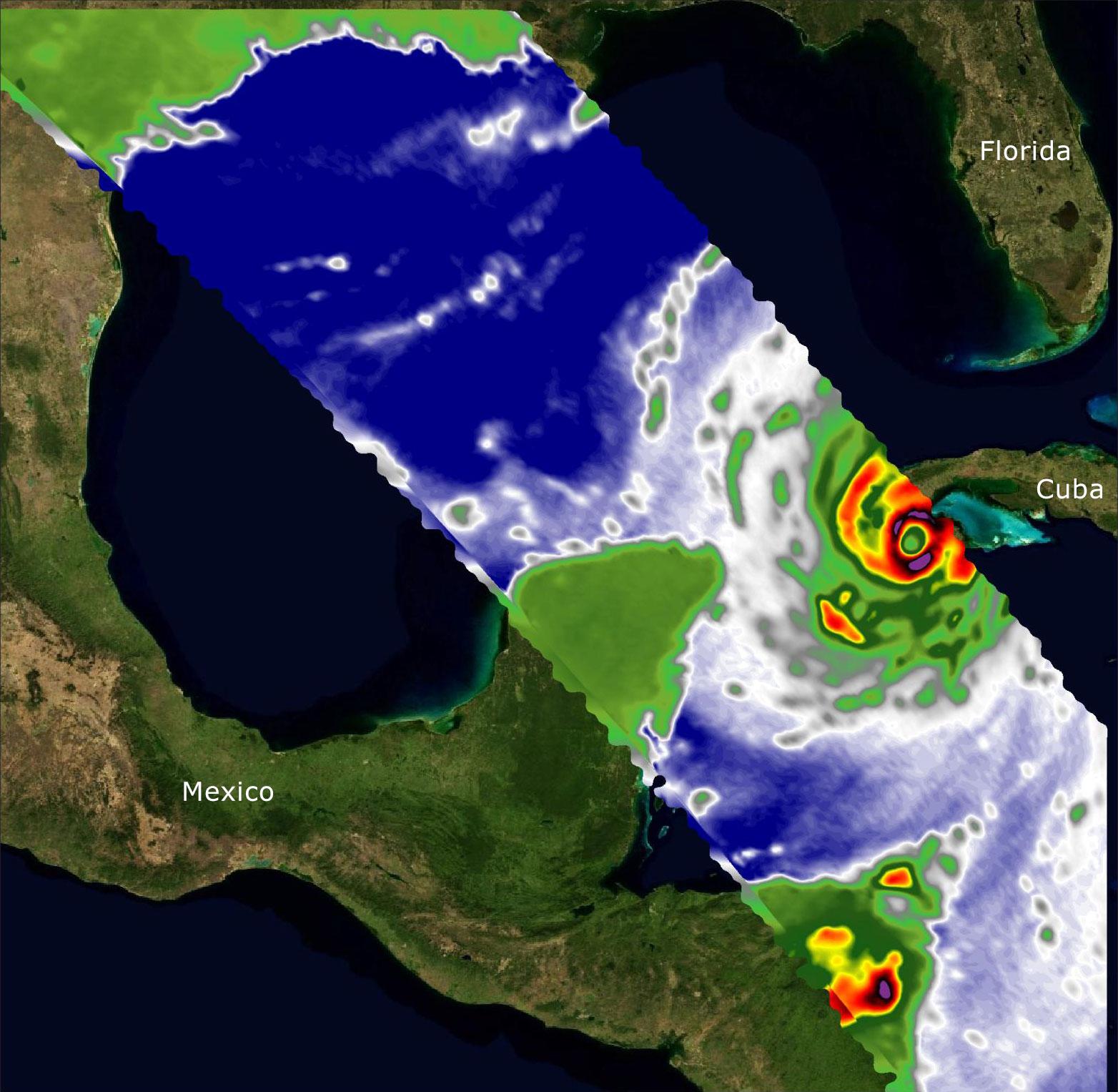
COWVR, TEMPEST Capture Vital Data on Hurricane Franklin
Full Resolution:
TIFF
(3.924 MB)
JPEG
(155.7 kB)
|
|
|
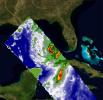
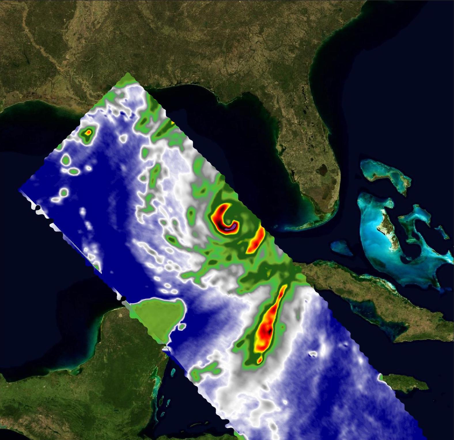
2023-08-29 |
Earth
|
COWVR
|
COWVR
TEMPEST
|
1576x1527x3 |
|
-
PIA25569:
-
COWVR, TEMPEST Capture Vital Data on Hurricane Idalia
Full Resolution:
TIFF
(5.962 MB)
JPEG
(250.3 kB)
|
|
|
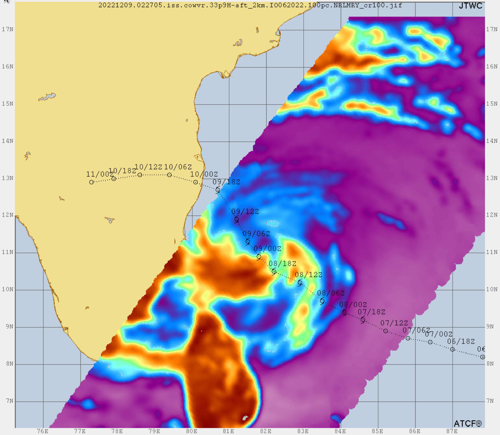
2023-02-23 |
Earth
|
COWVR
|
COWVR
TEMPEST
|
1752x1526x3 |

|
-
PIA25565:
-
COWVR, TEMPEST Track Tropical Cyclone Mandous
Full Resolution:
TIFF
(4.653 MB)
JPEG
(210.3 kB)
|
|
|
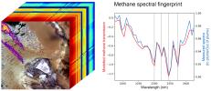
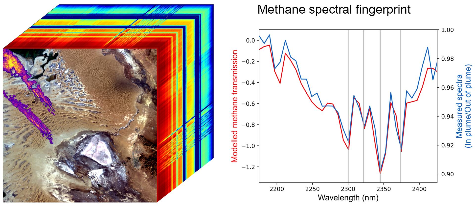
2022-10-25 |
Earth
|
Earth Surface Mineral Dust Source Investigation (EMIT)
|
EMIT
|
1925x834x3 |
|
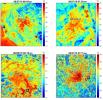
-
PIA25593:
-
EMIT Methane Spectral Fingerprint
Full Resolution:
TIFF
(2.575 MB)
JPEG
(246.3 kB)
|
|
|
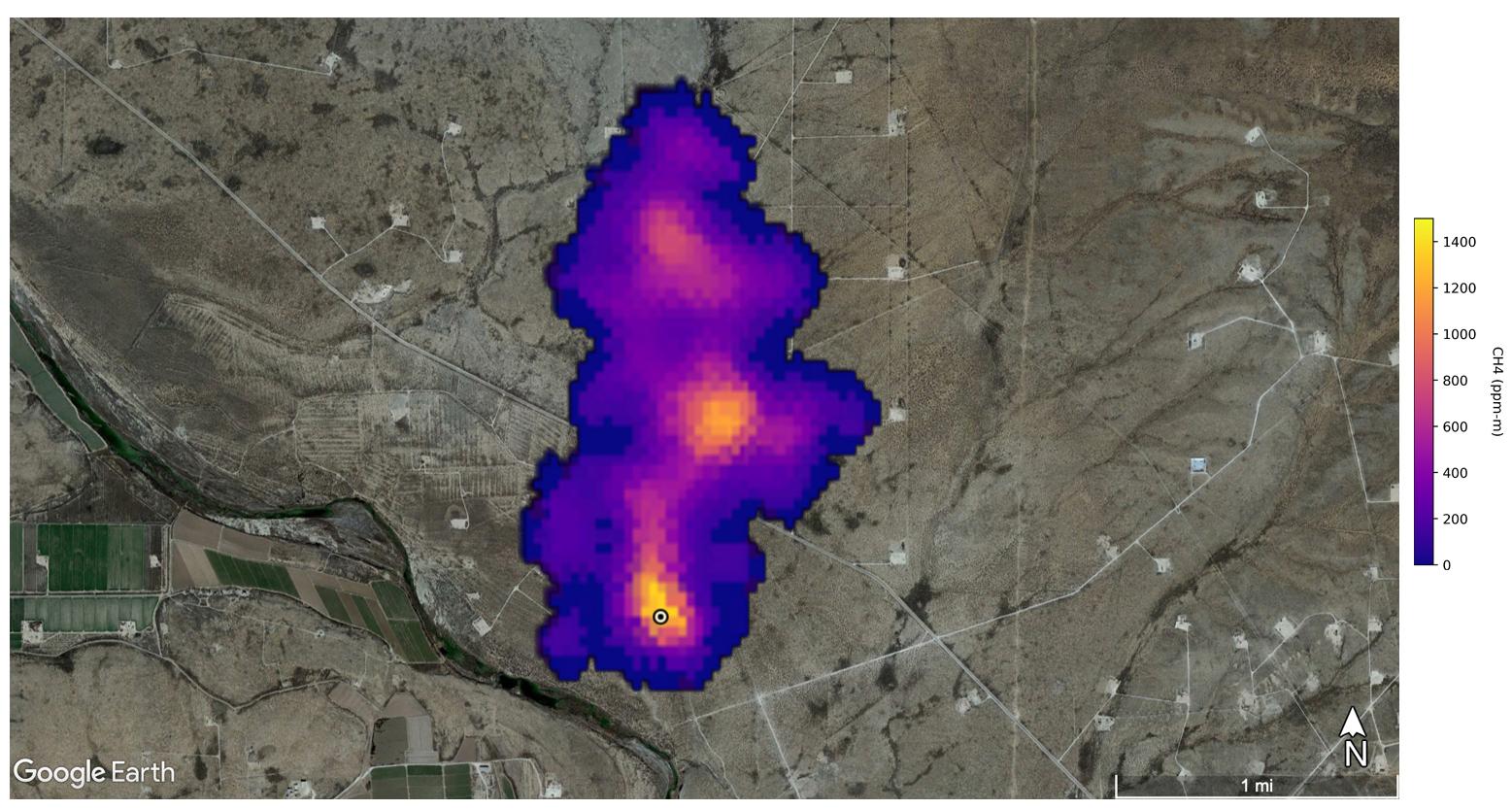
2022-10-25 |
Earth
|
Earth Surface Mineral Dust Source Investigation (EMIT)
|
EMIT
|
1557x834x3 |
|
-
PIA25592:
-
EMIT Spots Methane Hotspots
Full Resolution:
TIFF
(3.464 MB)
JPEG
(204.9 kB)
|
|
|
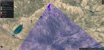
2022-10-12 |
Earth
|
Earth Surface Mineral Dust Source Investigation (EMIT)
|
EMIT
|
2457x2370x3 |
|
-
PIA25430:
-
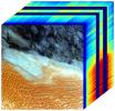
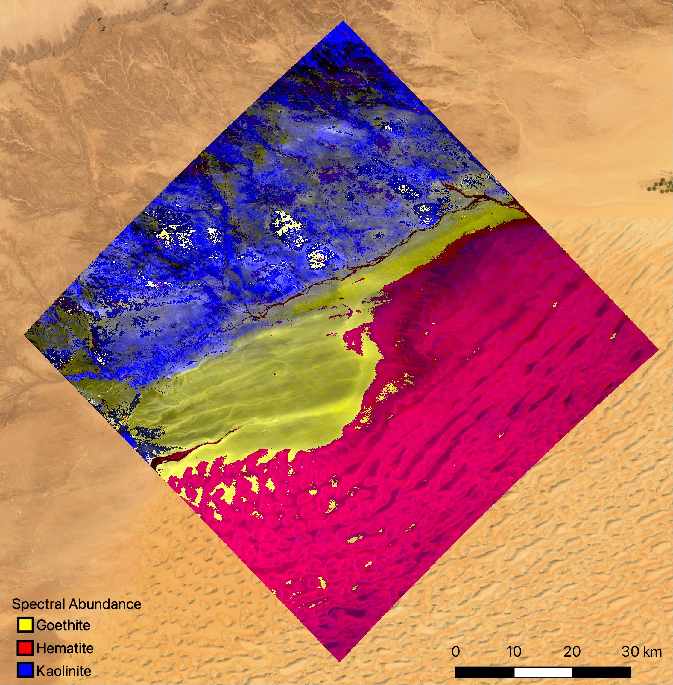
NASA's EMIT Mission Generates Image Cube of Surface Minerals in Southwestern Libya
Full Resolution:
TIFF
(15.61 MB)
JPEG
(788.9 kB)
|
|
|
2022-10-12 |
Earth
|
Earth Surface Mineral Dust Source Investigation (EMIT)
|
EMIT
|
1489x1039x3 |

|
-
PIA25429:
-
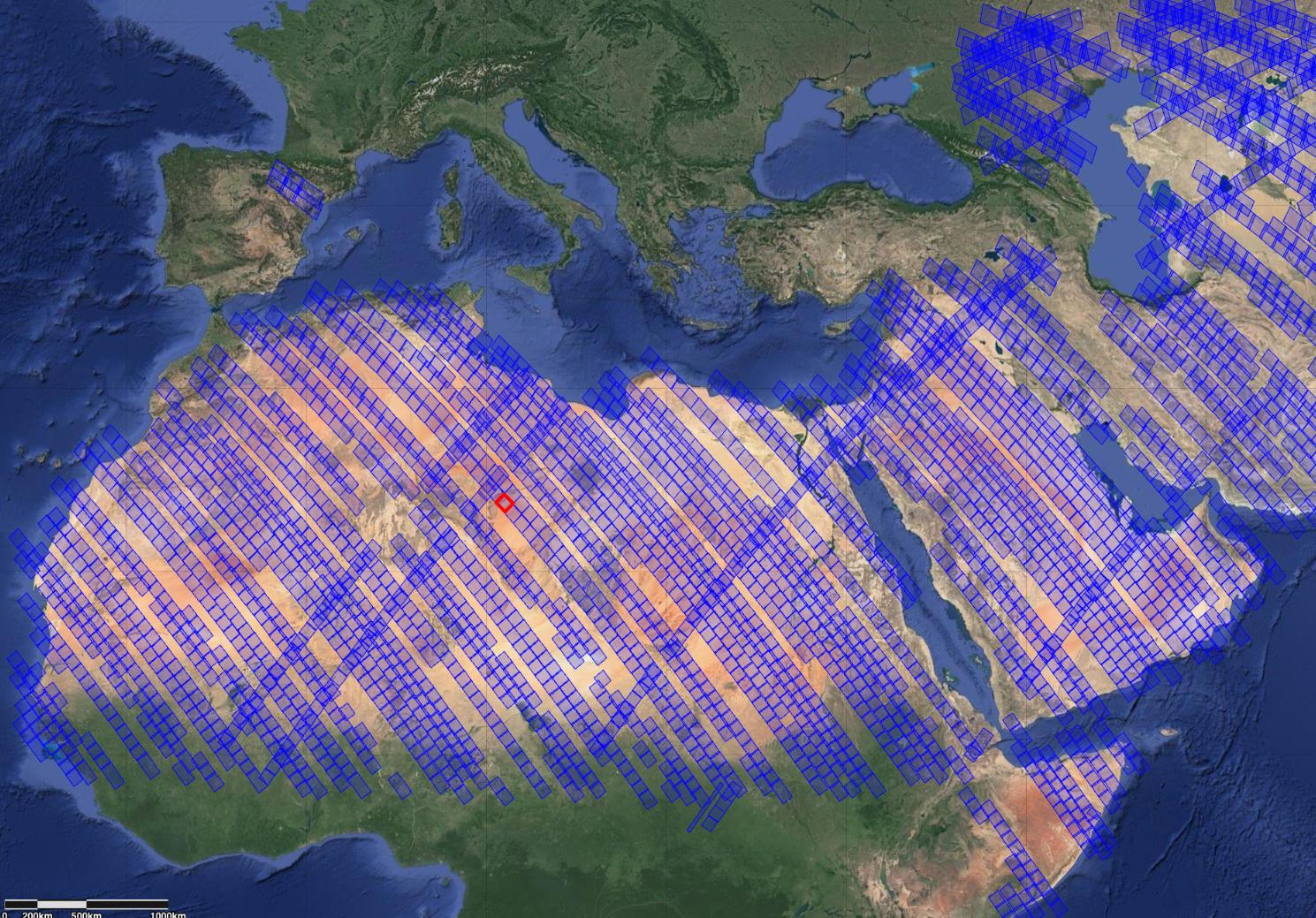
NASA's EMIT Measures Surface Dust in North Africa, Europe, the Middle East, Central Asia
Full Resolution:
TIFF
(4.643 MB)
JPEG
(393.1 kB)
|
|
|
2022-10-12 |
Earth
|
Earth Surface Mineral Dust Source Investigation (EMIT)
|
EMIT
|
1435x891x3 |

|
-
PIA25428:
-
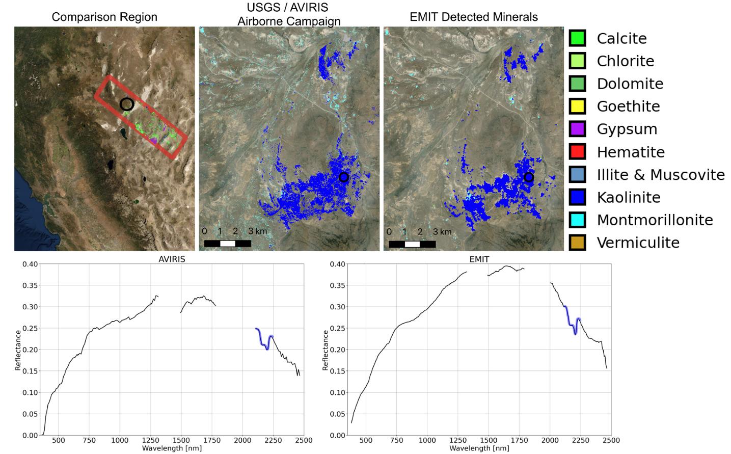
NASA's EMIT Collects Mineral Maps, Spectral Fingerprints From Nevada
Full Resolution:
TIFF
(1.876 MB)
JPEG
(184.9 kB)
|
|
|
2022-10-12 |
Earth
|
Earth Surface Mineral Dust Source Investigation (EMIT)
|
EMIT
|
774x750x3 |
|
-
PIA25427:
-
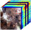
NASA's EMIT Generates Image Cube of Surface Minerals in Northwest Nevada
Full Resolution:
TIFF
(1.689 MB)
JPEG
(146.8 kB)
|
|
|
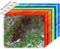
2022-10-12 |
Earth
|
Earth Surface Mineral Dust Source Investigation (EMIT)
|
EMIT
|
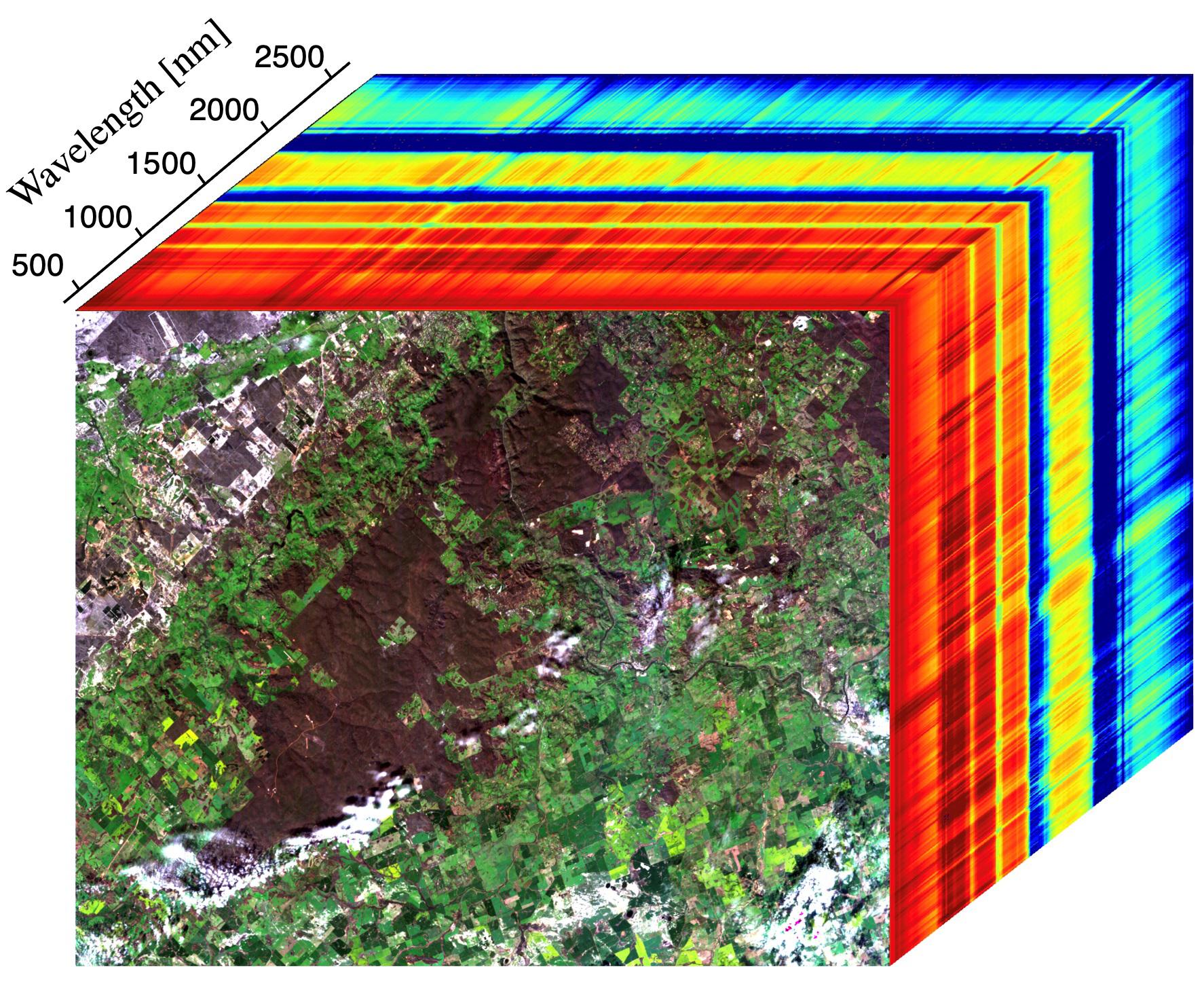
2249x2289x3 |

|
-
PIA25424:
-
EMIT Instrument's First Light
Full Resolution:
TIFF
(14.73 MB)
JPEG
(813.9 kB)
|
|
|
2022-09-28 |
Earth
|
COWVR
|
COWVR
TEMPEST
|
1564x1527x3 |
|
-
PIA25425:
-
COWVR and TEMPEST Image Hurricane Ian
Full Resolution:
TIFF
(5.736 MB)
JPEG
(250.1 kB)
|
|
|
2022-08-04 |
Earth
|
ECOSTRESS
|
|
3507x2480x3 |
|
-
PIA25488:
-
Evapotranspiration over Central Valley
Full Resolution:
TIFF
(24.59 MB)
JPEG
(1.422 MB)
|
|
|
2022-08-04 |
Earth
|
ECOSTRESS
|
|
3507x2480x3 |
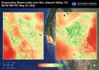
|
-
PIA25487:
-
Evaporative Stress Index over San Joaquin Valley
Full Resolution:
TIFF
(24.55 MB)
JPEG
(1.344 MB)
|
|
|
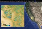
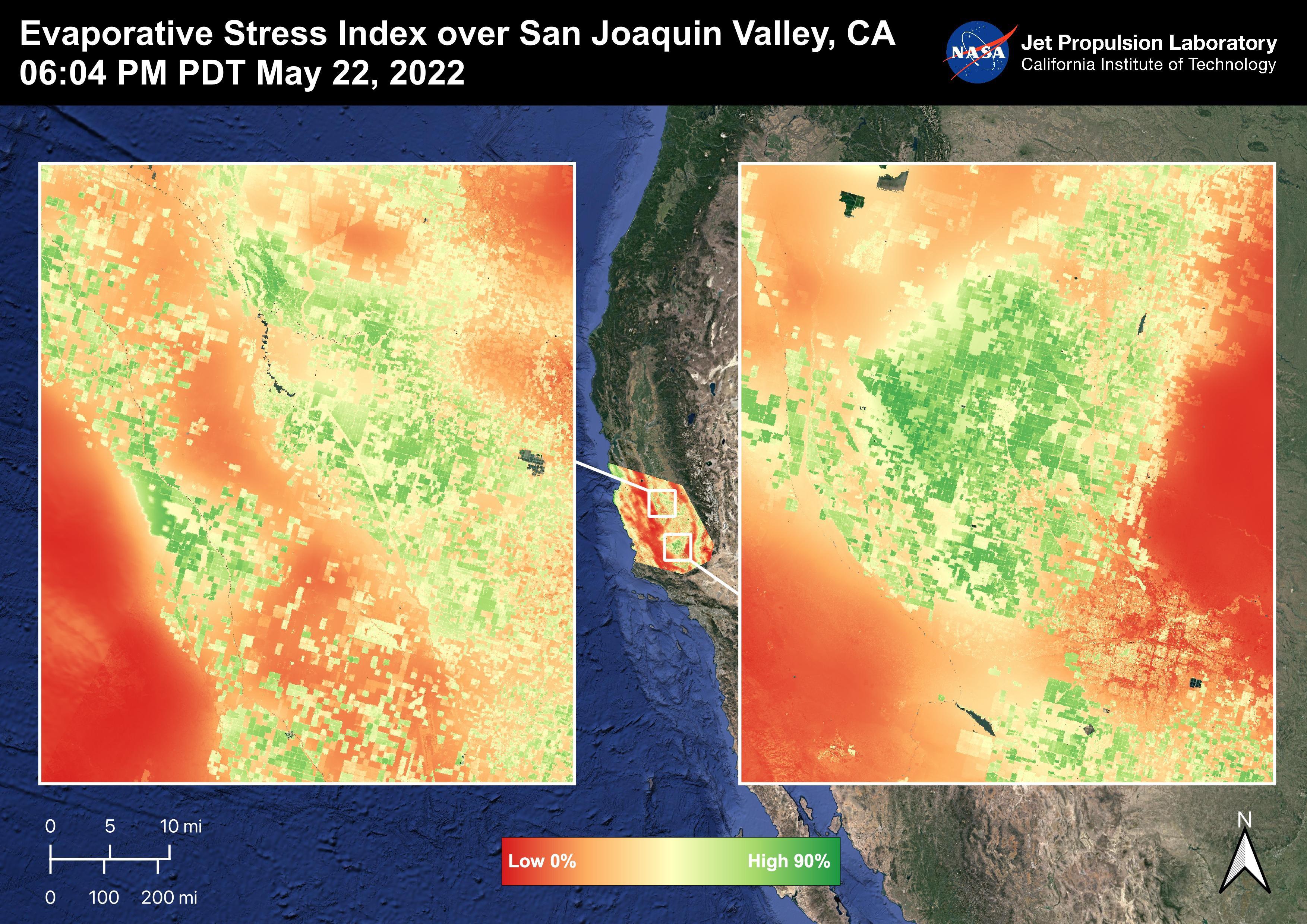
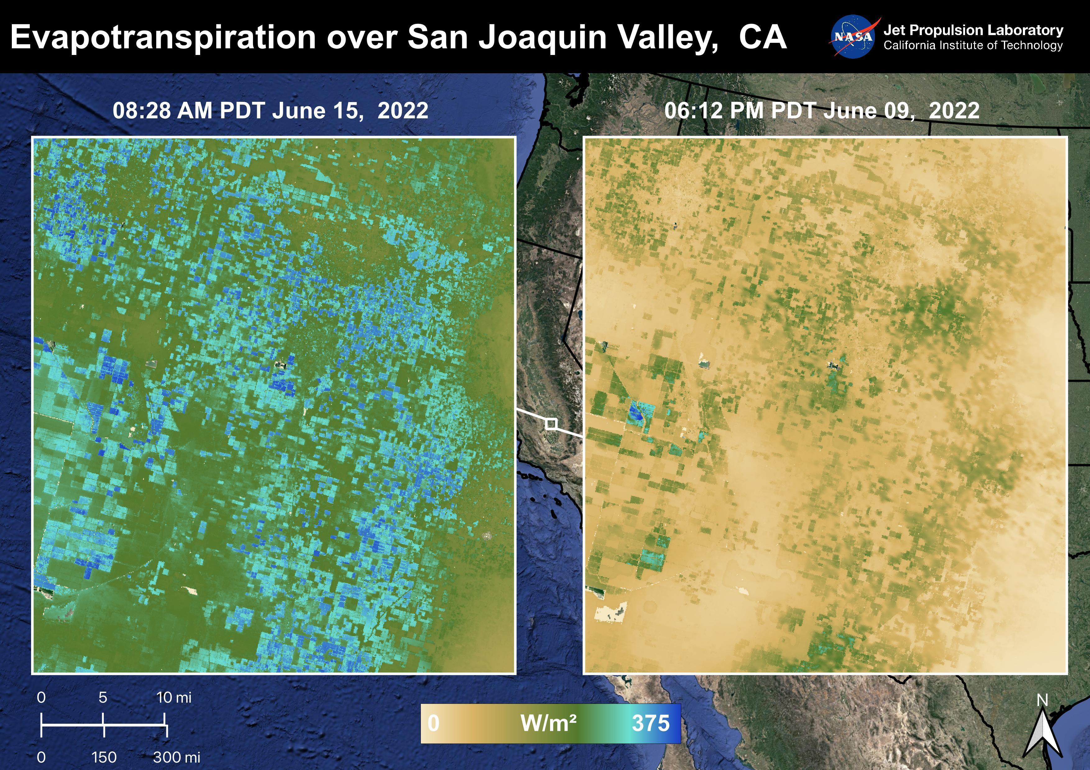
2022-08-04 |
Earth
|
ECOSTRESS
|
|
3507x2480x3 |

|
-
PIA25486:
-
Evapotranspiration over San Joaquin Valley
Full Resolution:
TIFF
(24.07 MB)
JPEG
(1.347 MB)
|
|
|
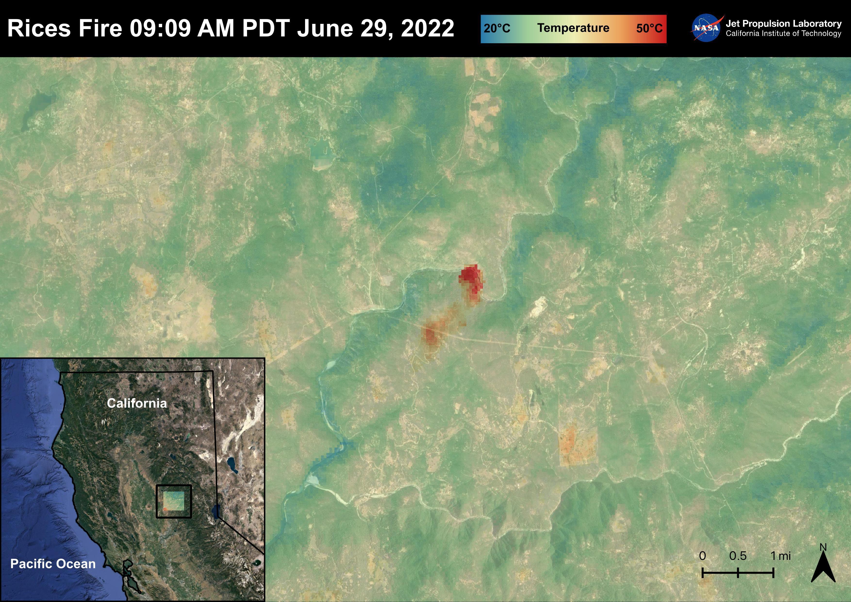
2022-08-04 |
Earth
|
ECOSTRESS
|
|
3507x2480x3 |
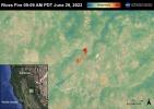
|
-
PIA25485:
-
The Rices Fire
Full Resolution:
TIFF
(23.34 MB)
JPEG
(1.067 MB)
|
|
|
2022-08-04 |
Earth
|
ECOSTRESS
|
|
3507x2480x3 |
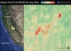
|
-
PIA25484:
-
The Electra Fire
Full Resolution:
TIFF
(23.43 MB)
JPEG
(1.034 MB)
|
|
|
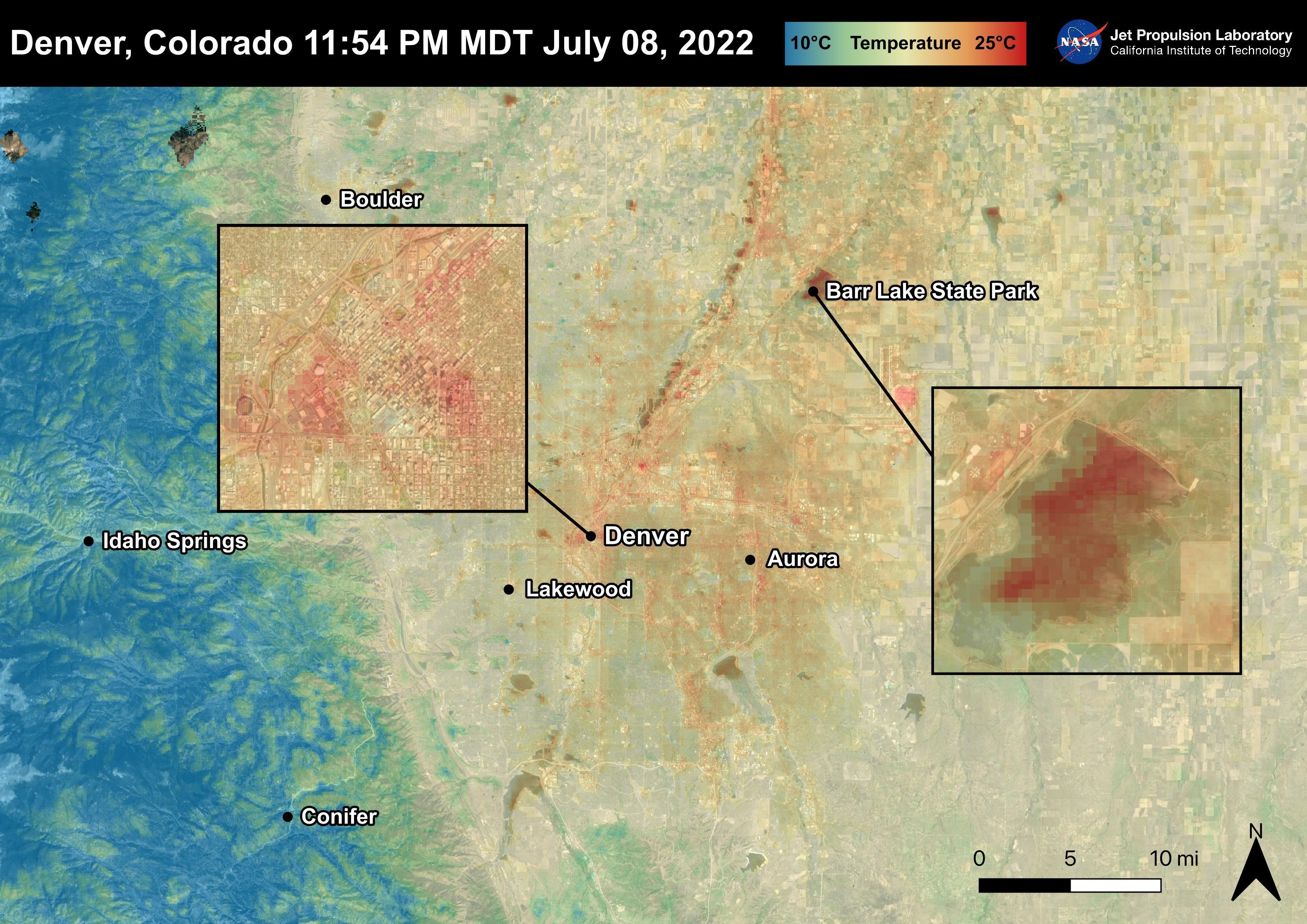
2022-08-04 |
Earth
|
ECOSTRESS
|
|
3507x2480x3 |
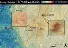
|
-
PIA25483:
-
Denver, CO
Full Resolution:
TIFF
(25.33 MB)
JPEG
(1.18 MB)
|
|
|
2022-08-04 |
Earth
|
ECOSTRESS
|
|
3507x2480x3 |
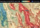
|
-
PIA25482:
-
Death Valley, CA
Full Resolution:
TIFF
(26.1 MB)
JPEG
(1.367 MB)
|
|
|
2022-08-04 |
Earth
|
ECOSTRESS
|
|
3507x2480x3 |
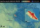
|
-
PIA25481:
-
The Oak Fire
Full Resolution:
TIFF
(21.67 MB)
JPEG
(865 kB)
|
|
|
2022-07-29 |
Earth
|
Earth Surface Mineral Dust Source Investigation (EMIT)
|
EMIT
|
1774x1458x3 |
|
-
PIA24529:
-
EMIT Instrument's First Light
Full Resolution:
TIFF
(7.334 MB)
JPEG
(508.6 kB)
|
|
|
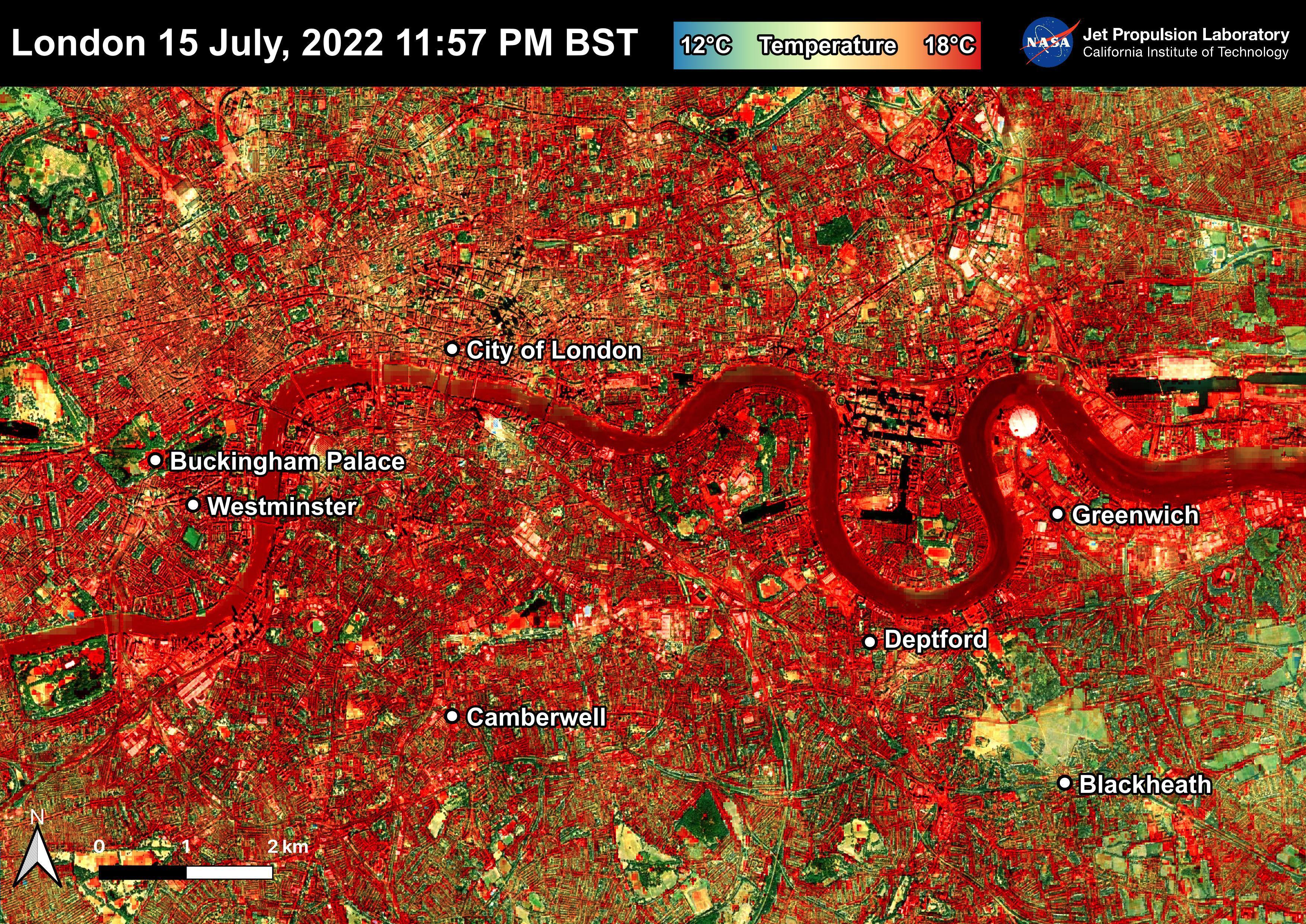
2022-07-22 |
Earth
|
ECOSTRESS
|
|
3507x2480x3 |
|
-
PIA25423:
-
NASA's ECOSTRESS Shows Overnight Heat in London
Full Resolution:
TIFF
(26.1 MB)
JPEG
(2.721 MB)
|
|
|
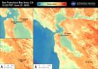
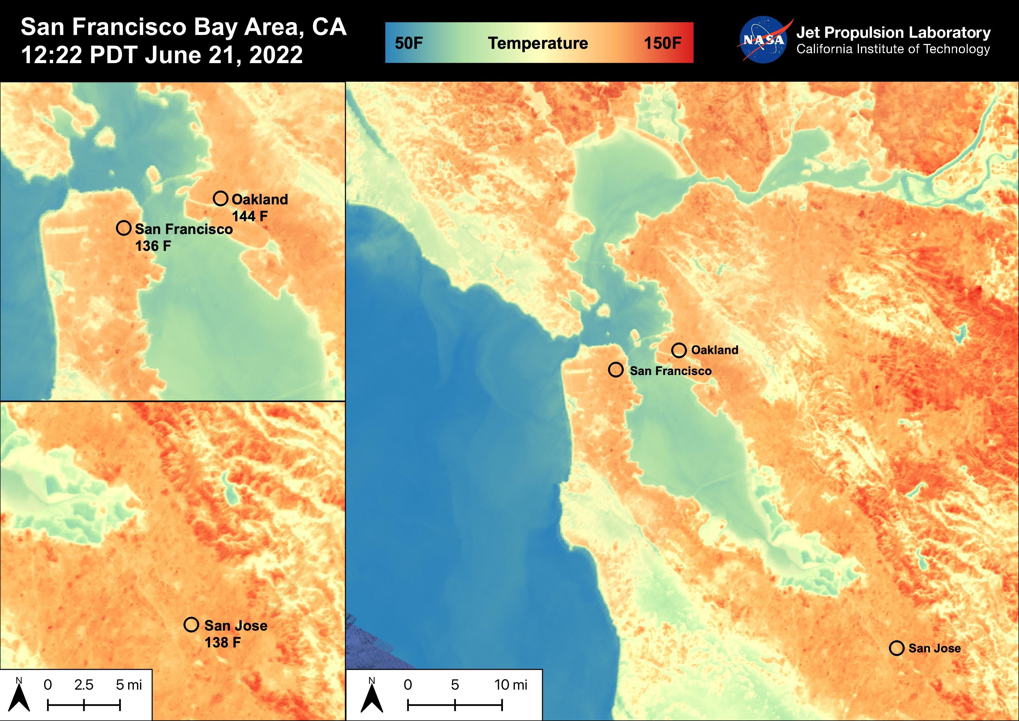
2022-06-30 |
Earth
|
ECOSTRESS
|
|
3507x2480x3 |
|
-
PIA25441:
-
High Temperatures in the San Francisco Bay Area
Full Resolution:
TIFF
(21.01 MB)
JPEG
(919.1 kB)
|
|
|
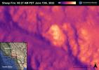
2022-06-30 |
Earth
|
ECOSTRESS
|
|
3507x2480x3 |
|
-
PIA25356:
-
Sheep Fire
Full Resolution:
TIFF
(16.45 MB)
JPEG
(598.1 kB)
|
|
|
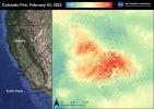
2022-06-30 |
Earth
|
ECOSTRESS
|
|
3507x2480x3 |
|
-
PIA25280:
-
Colorado Fire
Full Resolution:
TIFF
(17.17 MB)
JPEG
(810.7 kB)
|
|
|
2022-06-22 |
Earth
|
ECOSTRESS
|
|
3099x2201x3 |
|
-
PIA25422:
-
NASA's ECOSTRESS Shows Heat in Dallas and Fort Worth
Full Resolution:
TIFF
(20.47 MB)
JPEG
(2.22 MB)
|
|
|
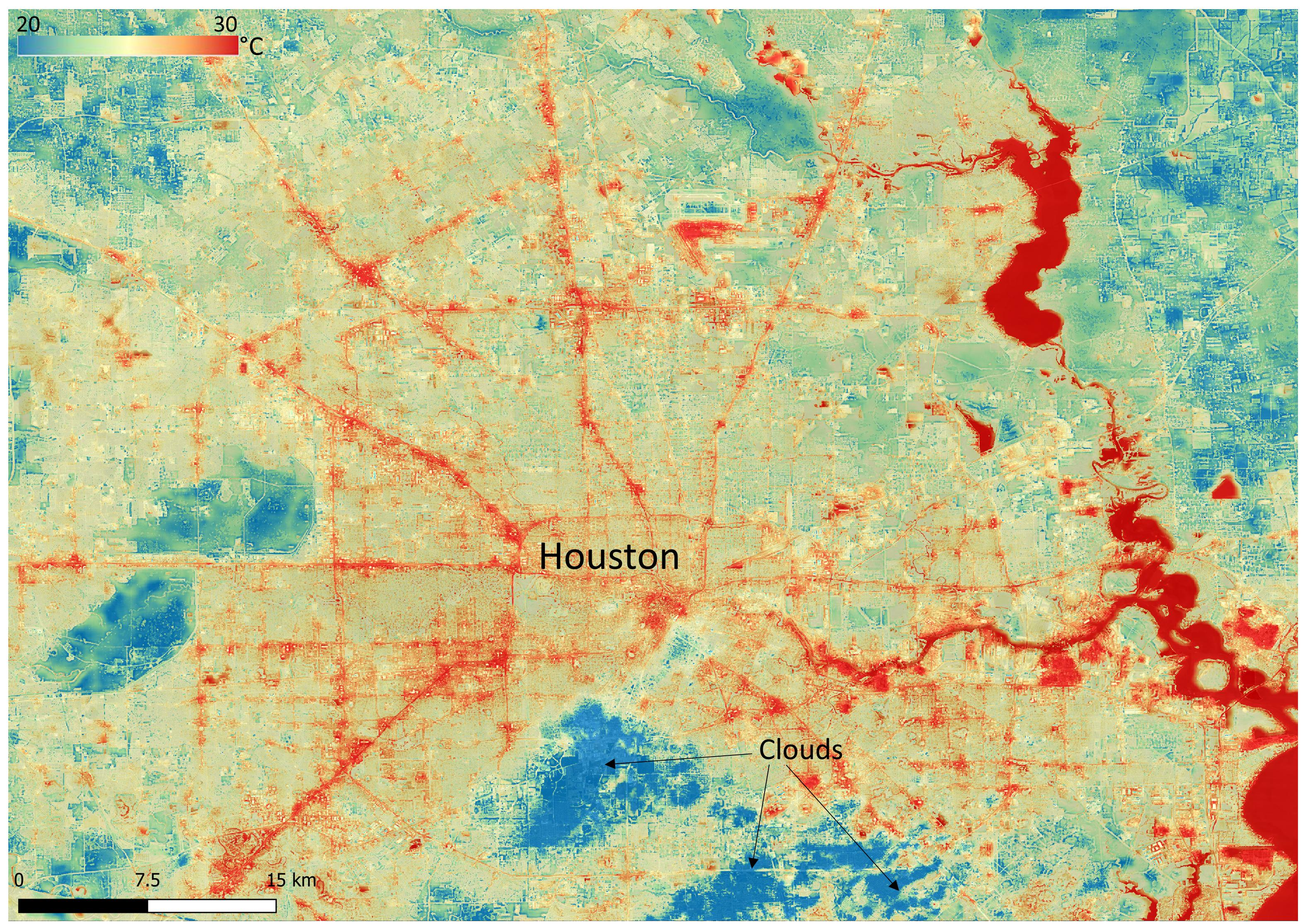
2022-06-22 |
Earth
|
ECOSTRESS
|
|
3161x2230x3 |
|
-
PIA25421:
-
NASA's ECOSTRESS Shows Surface Heat in Houston
Full Resolution:
TIFF
(21.16 MB)
JPEG
(1.711 MB)
|
|
|
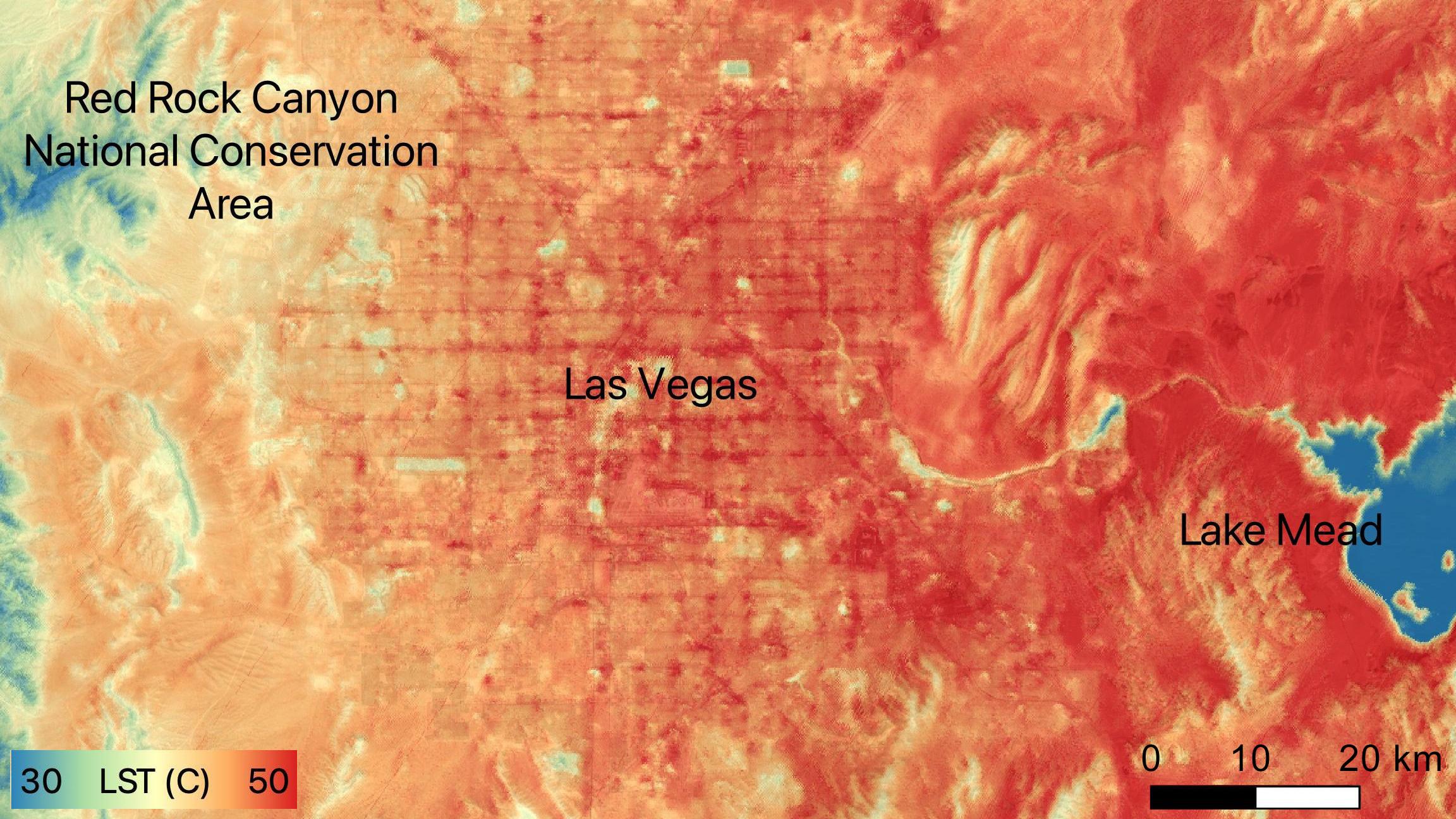
2022-06-15 |
Earth
|
ECOSTRESS
|
|
2304x1296x3 |

|
-
PIA24988:
-
NASA's ECOSTRESS Sees Las Vegas Streets Turn Up the Heat
Full Resolution:
TIFF
(8.962 MB)
JPEG
(479.4 kB)
|
|
|
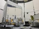
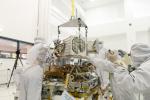
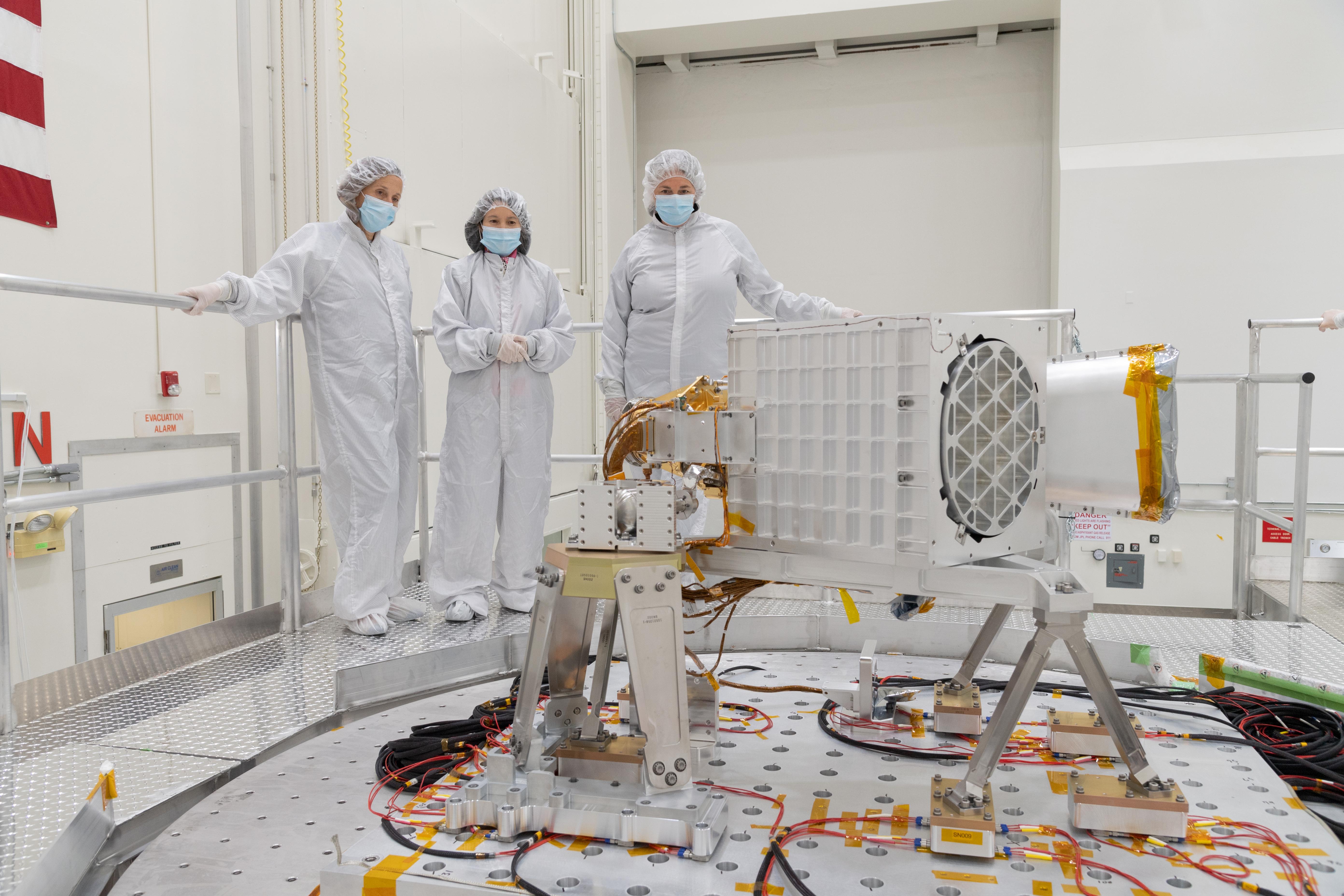
2022-06-01 |
Earth
|
Earth Surface Mineral Dust Source Investigation (EMIT)
|
EMIT
|
5568x3712x3 |

|
-
PIA25150:
-
EMIT Put to the Test at JPL
Full Resolution:
TIFF
(43.37 MB)
JPEG
(1.852 MB)
|
|
|
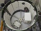
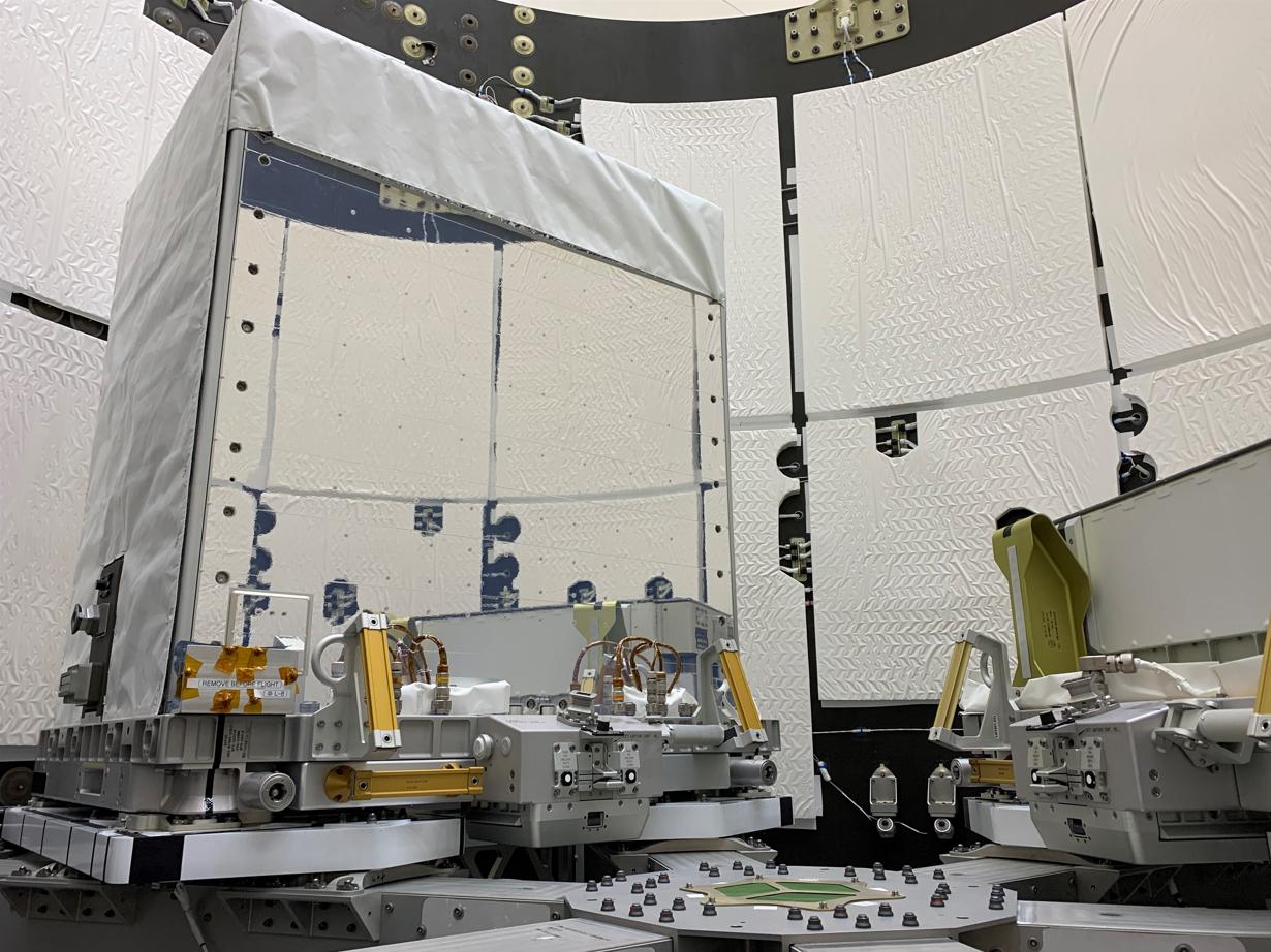
2022-05-12 |
Earth
|
Earth Surface Mineral Dust Source Investigation (EMIT)
|
EMIT
|
1230x922x3 |
|
-
PIA25149:
-
EMIT Inside SpaceX Falcon 9 Trunk Ahead of Transport
Full Resolution:
TIFF
(2.82 MB)
JPEG
(178.1 kB)
|
|
|
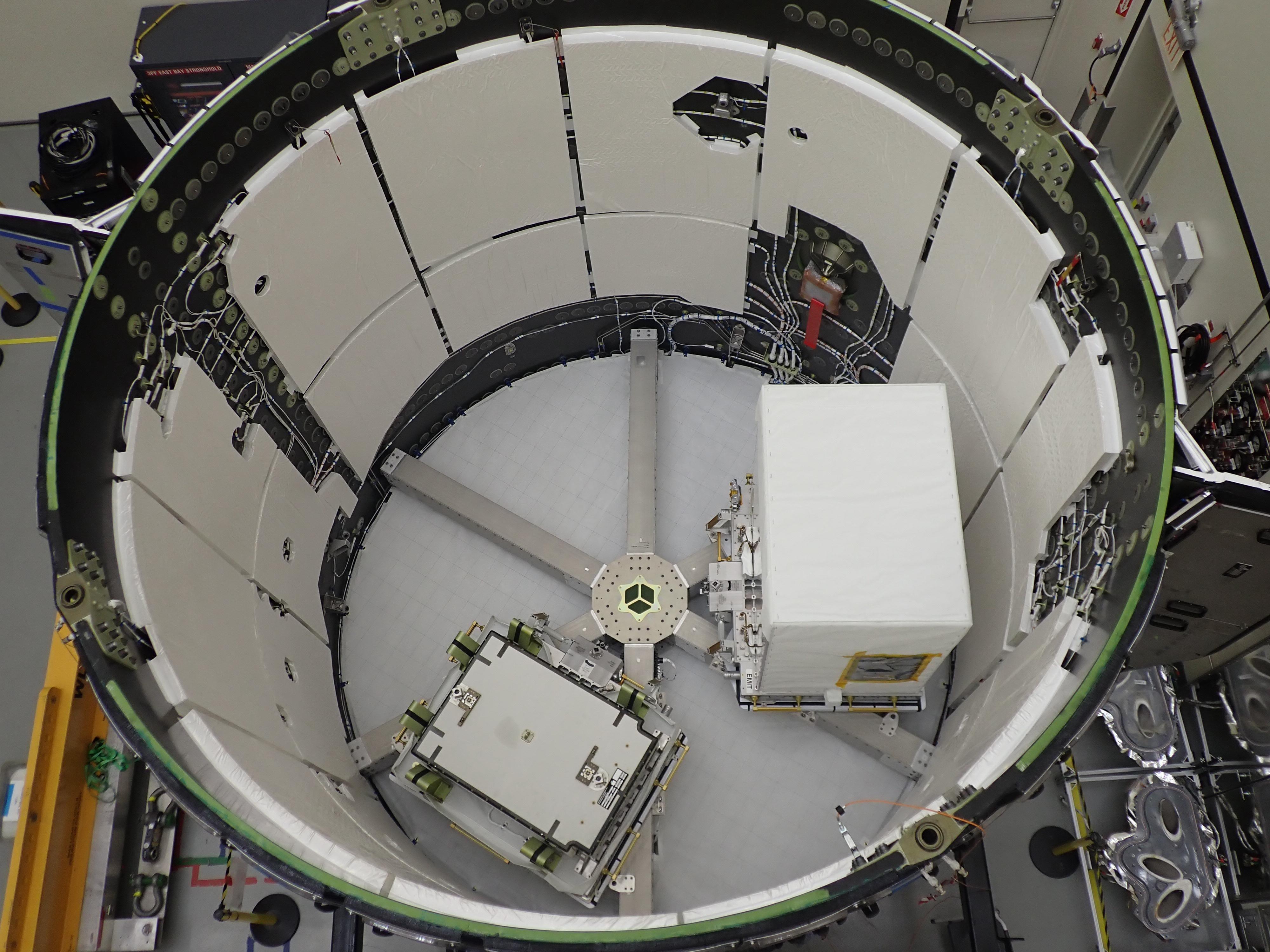
2022-05-12 |
Earth
|
Earth Surface Mineral Dust Source Investigation (EMIT)
|
EMIT
|
4000x3000x3 |
|
-
PIA25148:
-
EMIT Loaded Into SpaceX Falcon 9 Trunk Before Transport
Full Resolution:
TIFF
(28.26 MB)
JPEG
(1.117 MB)
|
|
|
2022-05-12 |
Earth
|
ECOSTRESS
|
|
3376x2477x3 |
|
-
PIA24987:
-
ECOSTRESS Detects Heat Islands in Indian Heat Wave
Full Resolution:
TIFF
(25.1 MB)
JPEG
(2.193 MB)
|
|
|
2022-05-02 |
Earth
|
Earth Surface Mineral Dust Source Investigation (EMIT)
|
EMIT
|
7955x5303x3 |
|
-
PIA25146:
-
EMIT's Components Come Together at JPL
Full Resolution:
TIFF
(89.44 MB)
JPEG
(5.066 MB)
|
|
|
2022-05-02 |
Earth
|
Earth Surface Mineral Dust Source Investigation (EMIT)
|
EMIT
|
2522x1199x3 |

|
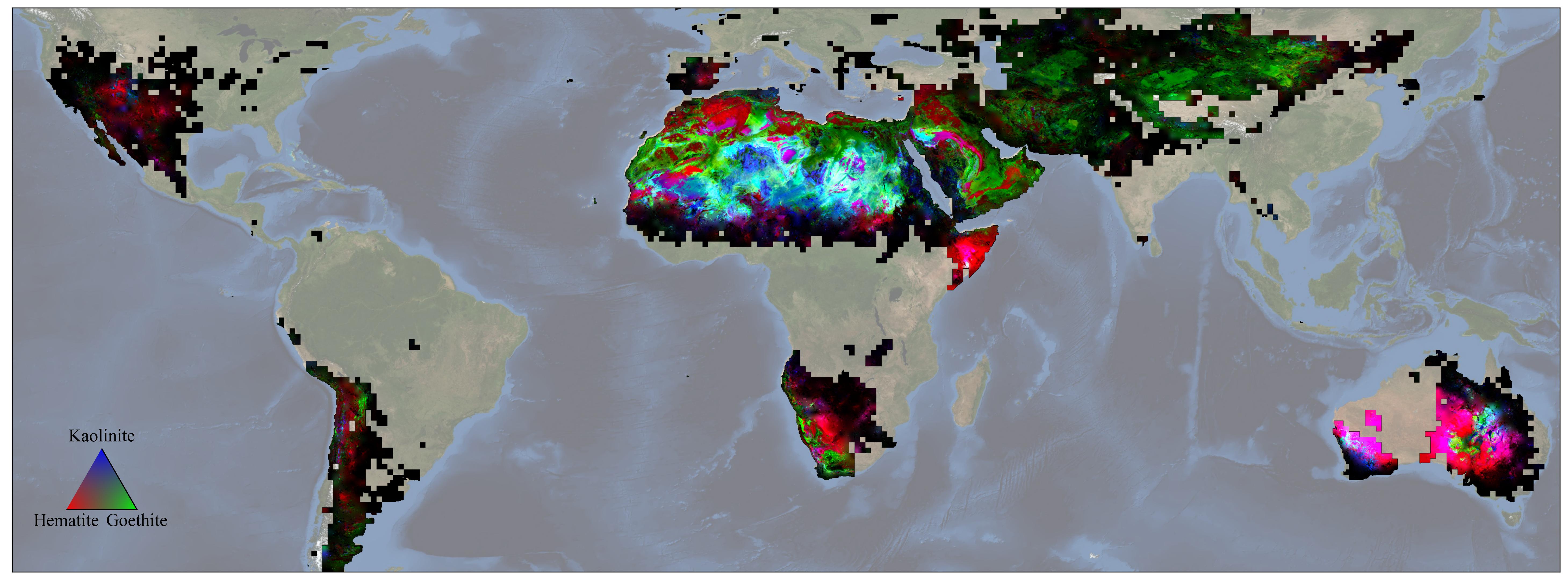
-
PIA25145:
-
Global Mineral Dust Source Regions to Be Measured by EMIT
Full Resolution:
TIFF
(1.717 MB)
JPEG
(167.4 kB)
|
|
|
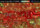
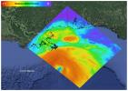
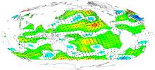
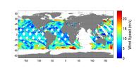
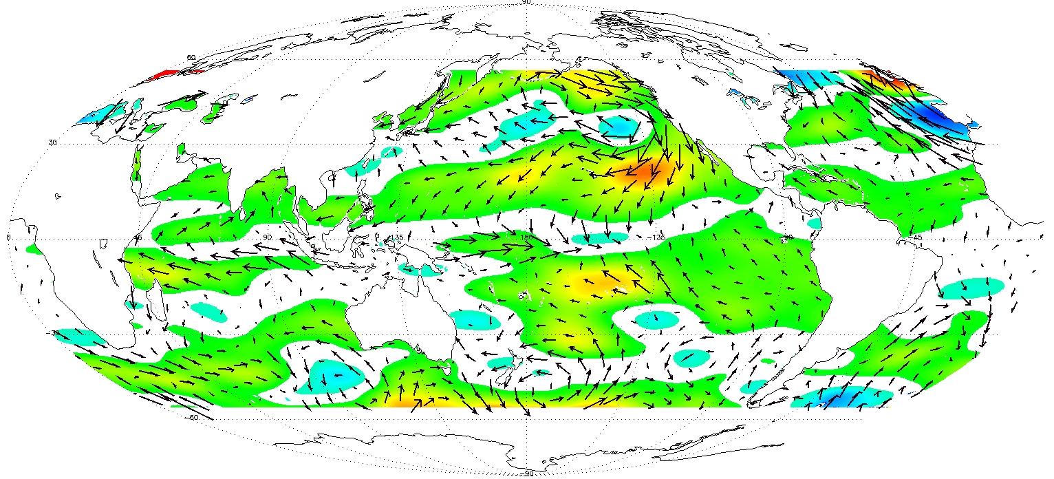
2022-02-08 |
Earth
|
COWVR
|
Compact Ocean Wind Vector Radiometer (COWVR)
|
8817x3019x3 |
|
-
PIA24985:
-
COWVR's New Map
Full Resolution:
TIFF
(78.07 MB)
JPEG
(4.831 MB)
|
|
|
2021-10-27 |
Earth
|
ECOSTRESS
|
|
3507x2480x3 |
|
-
PIA24916:
-
La Palma Volcano
Full Resolution:
TIFF
(16.12 MB)
JPEG
(719.5 kB)
|
|
|
2021-10-07 |
Earth
|
ECOSTRESS
|
|
3507x2480x3 |
|
-
PIA24210:
-
Hurricane Ida, August 27, 2021
Full Resolution:
TIFF
(21.59 MB)
JPEG
(1.144 MB)
|
|
|
2021-10-07 |
Earth
|
ECOSTRESS
|
|
3507x2480x3 |
|
-
PIA24209:
-
Glass Fire, September 27, 2020
Full Resolution:
TIFF
(14.05 MB)
JPEG
(854.1 kB)
|
|
|
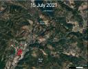
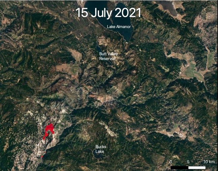
2021-07-29 |
Earth
|
ECOSTRESS
|
|
731x573x3 |
|
-
PIA23696:
-
ECOSTRESS Views 2021 Northern California Dixie Fire
Full Resolution:
TIFF
(1.257 MB)
JPEG
(113.3 kB)
|
|
|
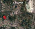
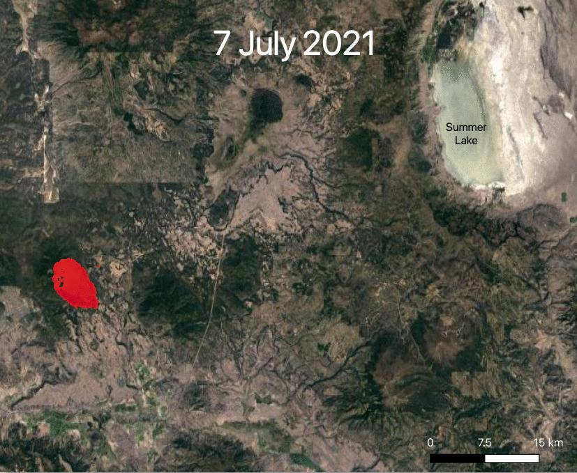
2021-07-29 |
Earth
|
ECOSTRESS
|
|
827x679x3 |
|
-
PIA23695:
-
ECOSTRESS Views 2021 Southern Oregon Bootleg Fire
Full Resolution:
TIFF
(1.685 MB)
JPEG
(109.8 kB)
|
|
|
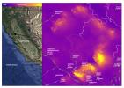
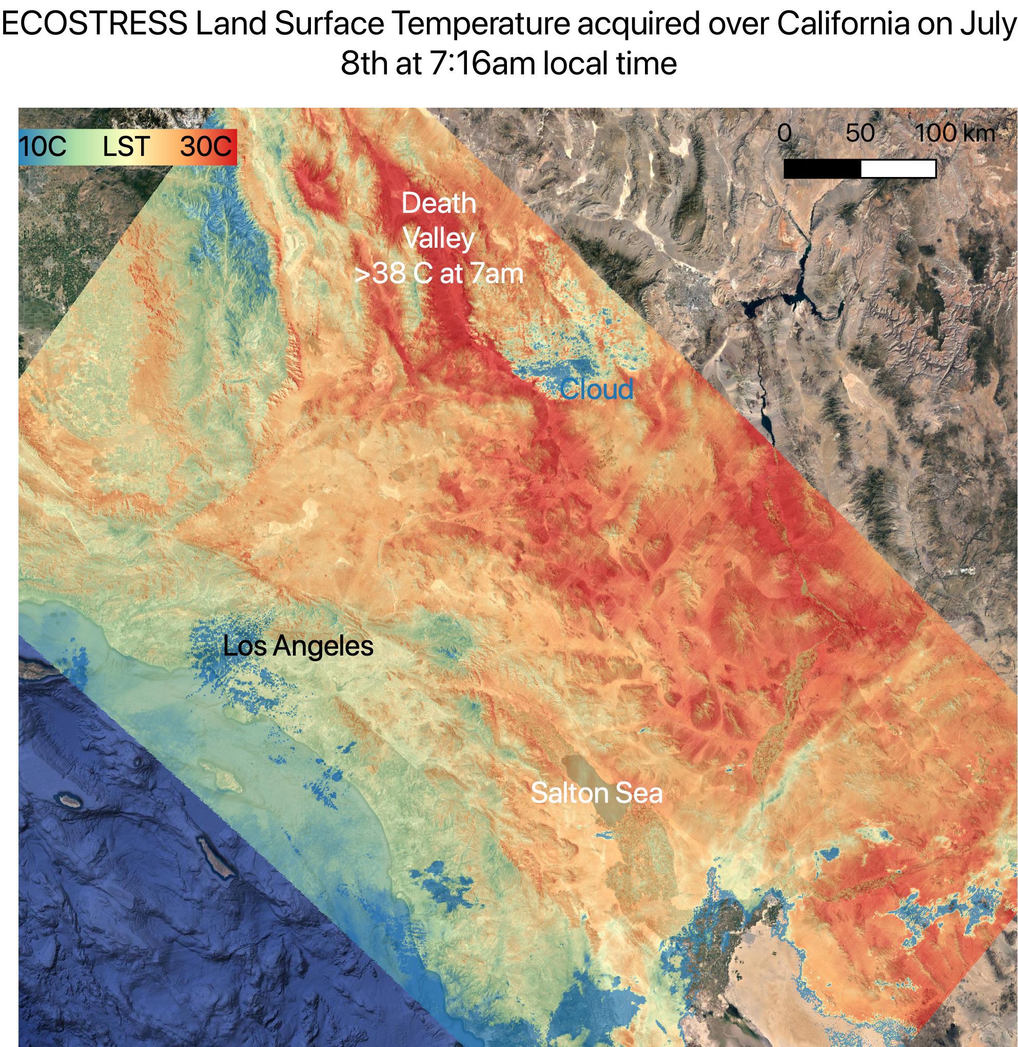
2021-07-15 |
Earth
|
ECOSTRESS
|
|
1984x2041x3 |
|
-
PIA23694:
-
July 2021 Heat Wave Ground Temperature
Full Resolution:
TIFF
(12.15 MB)
JPEG
(746.2 kB)
|
|
|
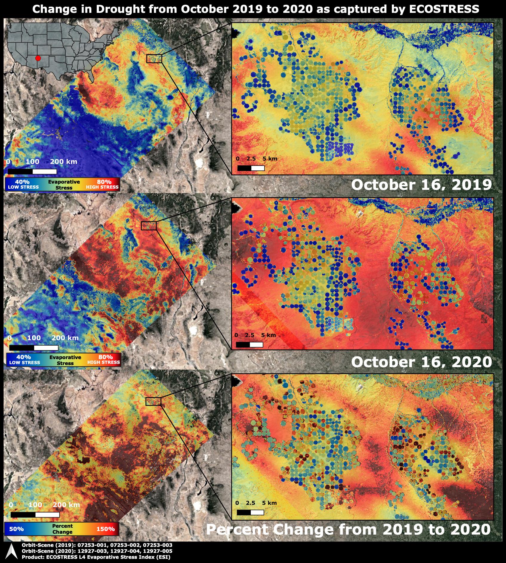
2020-10-28 |
Earth
|
ECOSTRESS
|
|
1695x1883x3 |

|
-
PIA24132:
-
ECOSTRESS Drought Stress Comparison
Full Resolution:
TIFF
(9.579 MB)
JPEG
(930 kB)
|
|
|
2020-10-02 |
Earth
|
ECOSTRESS
|
|
1825x1894x3 |

|
-
PIA23721:
-
NASA's ECOSTRESS Images California Wildfires From Space
Full Resolution:
TIFF
(10.37 MB)
JPEG
(633.2 kB)
|
|
|
2020-09-08 |
Earth
|
ECOSTRESS
|
|
1600x1007x3 |
|
-
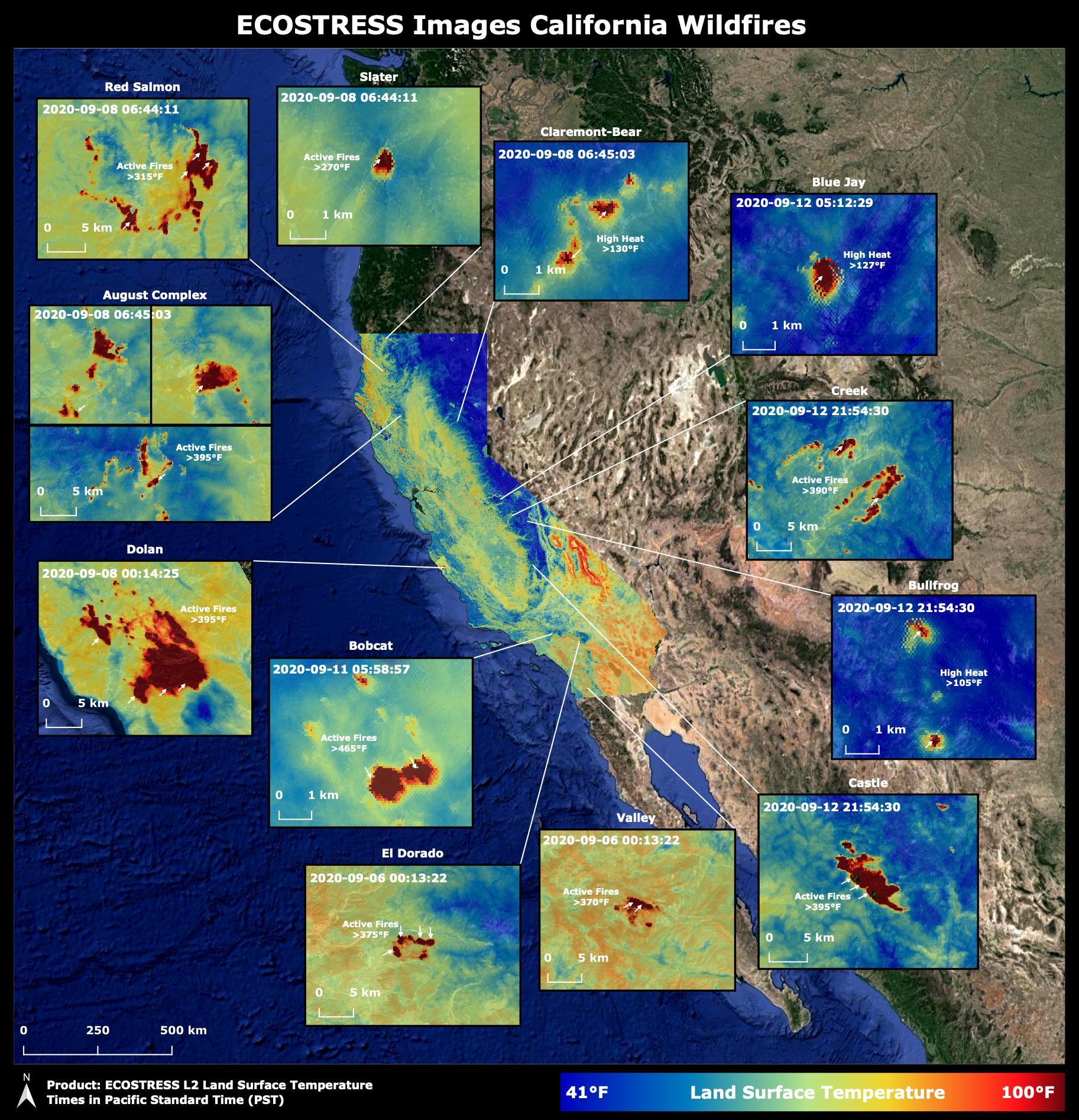
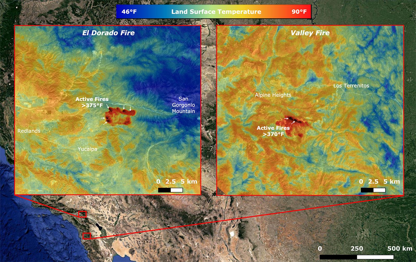
PIA23788:
-
NASA's ECOSTRESS Takes Surface Temperature Around California Fires
Full Resolution:
TIFF
(4.835 MB)
JPEG
(361.7 kB)
|
|
|
2020-08-27 |
Earth
|
ECOSTRESS
|
|
3507x2480x3 |
|
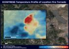
-
PIA23215:
-
NASA's ECOSTRESS Sees Fire-Induced Tornado From Space
Full Resolution:
TIFF
(21.72 MB)
JPEG
(1.14 MB)
|
|
|
2020-08-19 |
Earth
|
ECOSTRESS
|
|
3447x2404x3 |
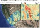
|
-
PIA23787:
-
Death Valley Heats Up
Full Resolution:
TIFF
(23.97 MB)
JPEG
(1.434 MB)
|
|
|
2020-08-19 |
Earth
|
ECOSTRESS
|
|
3507x2480x3 |
|
-
PIA23786:
-
Los Angeles Heat Wave
Full Resolution:
TIFF
(19.81 MB)
JPEG
(1.073 MB)
|
|
|
2020-08-03 |
Earth
|
ECOSTRESS
|
|
1650x1023x3 |

|
-
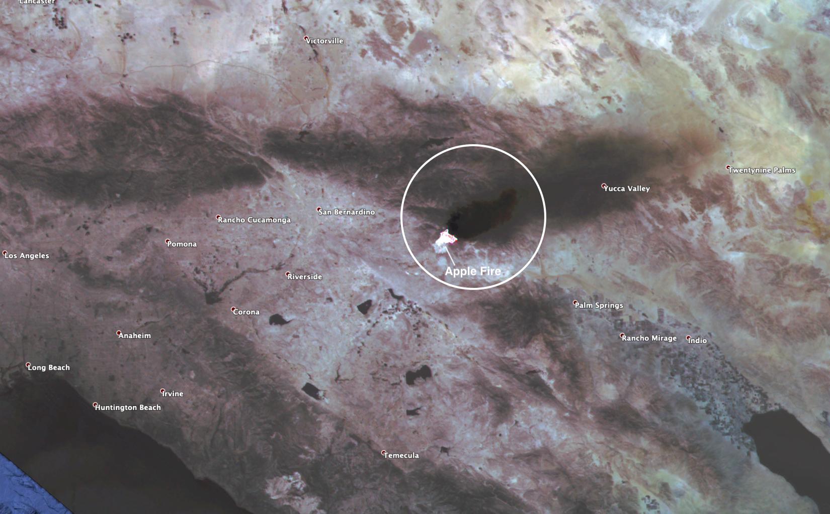
PIA23799:
-
ECOSTRESS Spies Apple Fire's Smoke Plume
Full Resolution:
TIFF
(4.924 MB)
JPEG
(188.5 kB)
|
|
|
2020-08-03 |
Earth
|
ECOSTRESS
|
|
2908x2224x3 |
|
-
PIA23798:
-
ECOSTRESS Gauges the Apple Fire's Temperature From Space
Full Resolution:
TIFF
(14.41 MB)
JPEG
(620.1 kB)
|
|
|
2020-02-04 |
Earth
|
ECOSTRESS
|
|
772x440x3 |

|
-
PIA23430:
-
The ECOSTRESS Mission Spots Plants as They Wake Up
Full Resolution:
TIFF
(1.02 MB)
JPEG
(72.92 kB)
|
|
|
2019-11-05 |
Earth
|
ECOSTRESS
|
|
720x715x3 |
|
-
PIA23432:
-
Drought-Stressed Forest Fueled Amazon Fires
Full Resolution:
TIFF
(1.545 MB)
JPEG
(112.1 kB)
|
|
|
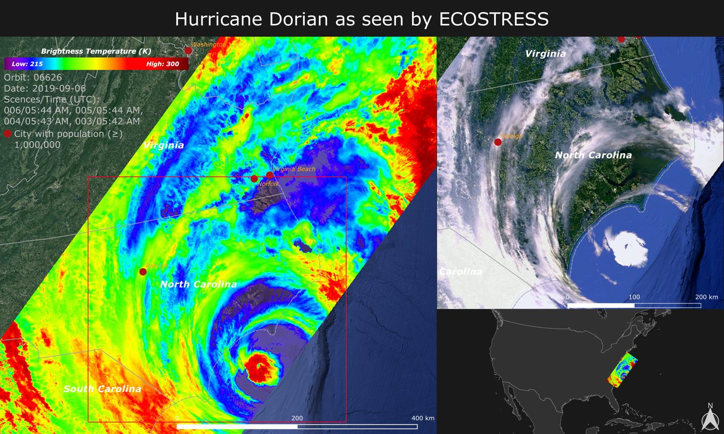
2019-09-18 |
Earth
|
ECOSTRESS
|
|
1430x857x3 |

|
-
PIA23422:
-
NASA Images Hurricane Dorian's Temperature from Space
Full Resolution:
TIFF
(3.196 MB)
JPEG
(252.8 kB)
|
|
|
2019-08-28 |
Earth
|
ECOSTRESS
|
|
1867x1132x3 |
|
-
PIA23357:
-
Amazon Fires Seen by NASA's ECOSTRESS
Full Resolution:
TIFF
(6.142 MB)
JPEG
(260.2 kB)
|
|
|
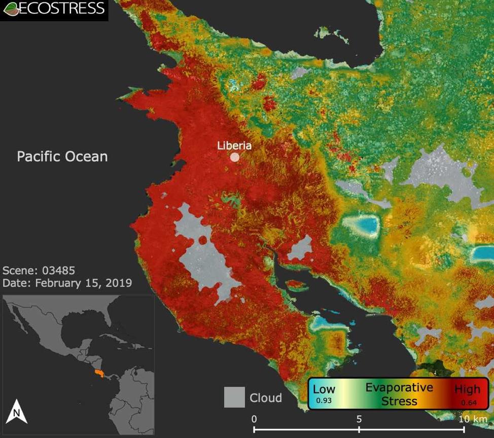
2019-08-08 |
Earth
|
ECOSTRESS
|
|
974x864x3 |
|
-
PIA22839:
-
ECOSTRESS Focuses on Costa Rican Drought
Full Resolution:
TIFF
(1.922 MB)
JPEG
(129.8 kB)
|
|
|
2019-07-12 |
Earth
|
Orbiting Carbon Observatory (OCO-3)
|
OCO-3
|
1440x841x3 |
|
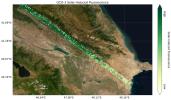
-
PIA23353:
-
OCO-3's First Solar-Induced Fluorescence Measurements
Full Resolution:
TIFF
(3.003 MB)
JPEG
(203.5 kB)
|
|
|
2019-07-12 |
Earth
|
Orbiting Carbon Observatory (OCO-3)
|
OCO-3
|
1007x701x3 |

|
-
PIA23352:
-
OCO-3's First CO2 Measurements
Full Resolution:
TIFF
(1.255 MB)
JPEG
(99.61 kB)
|
|
|
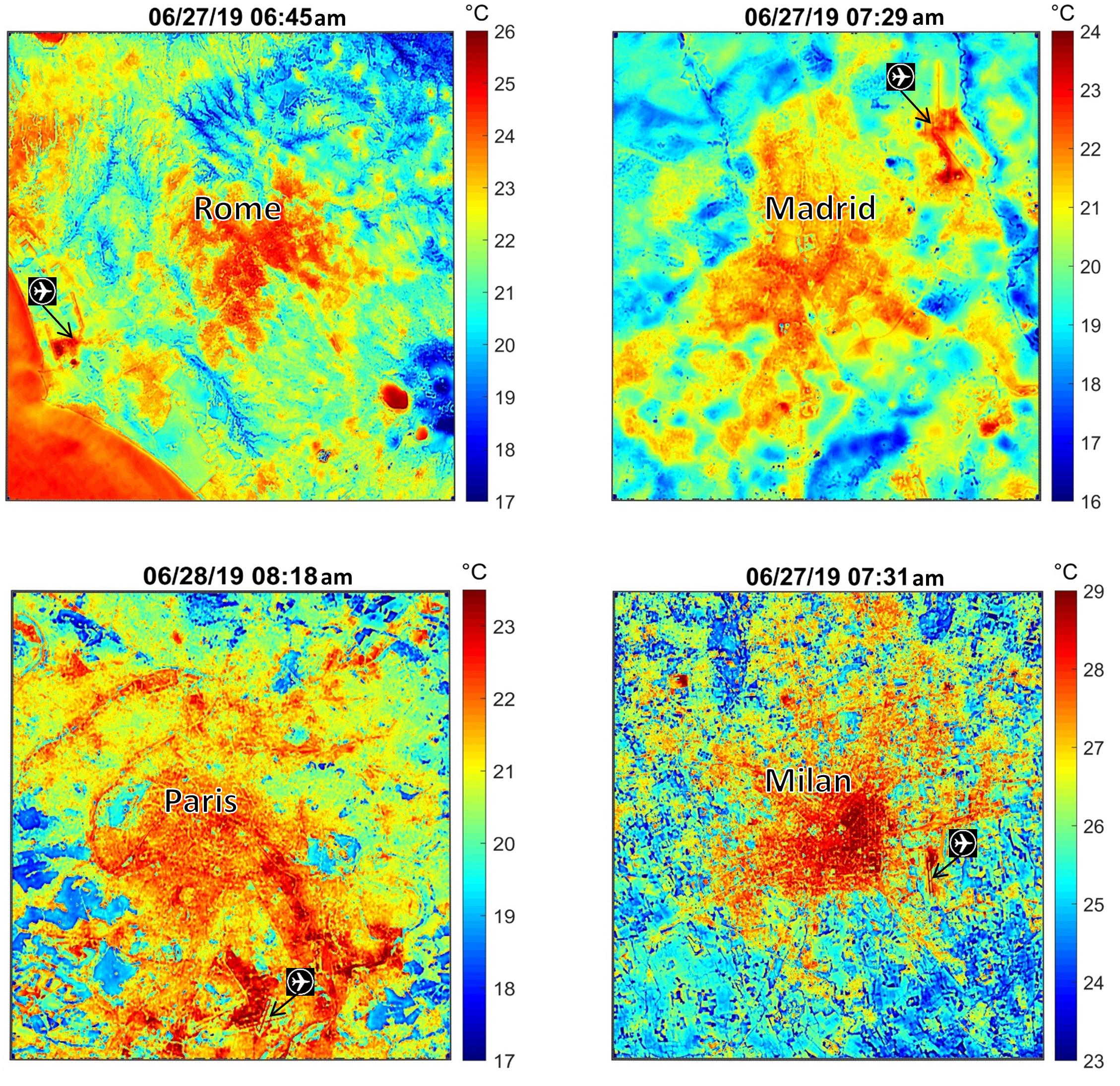
2019-07-02 |
Earth
|
ECOSTRESS
|
|
2258x2190x3 |
|
-
PIA23148:
-
NASA's ECOSTRESS Maps Europe Heat Wave
Full Resolution:
TIFF
(13.41 MB)
JPEG
(928.6 kB)
|
|
|
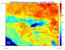
2018-09-18 |
Earth
|
ECOSTRESS
|
|
1473x1105x3 |
|
-
PIA22703:
-
NASA's ECOSTRESS Detects Surface Temperature Variations in Los Angeles
Full Resolution:
TIFF
(2.25 MB)
JPEG
(180.7 kB)
|
|
|
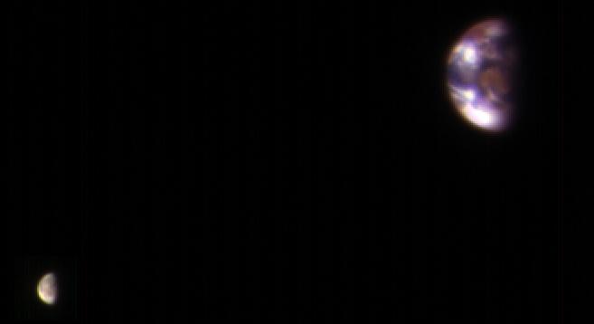
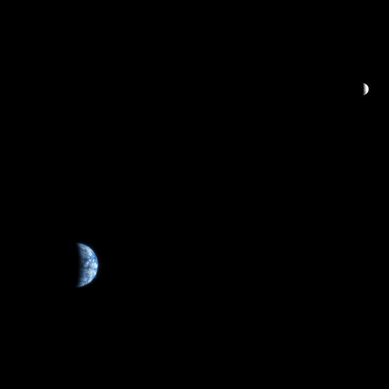
2017-01-06 |
Earth
|
Mars Reconnaissance Orbiter (MRO)
|
HiRISE
|
657x358x3 |

|
-
PIA21260:
-
Earth and Its Moon, as Seen From Mars
Full Resolution:
TIFF
(213.9 kB)
JPEG
(7.02 kB)
|
|
|
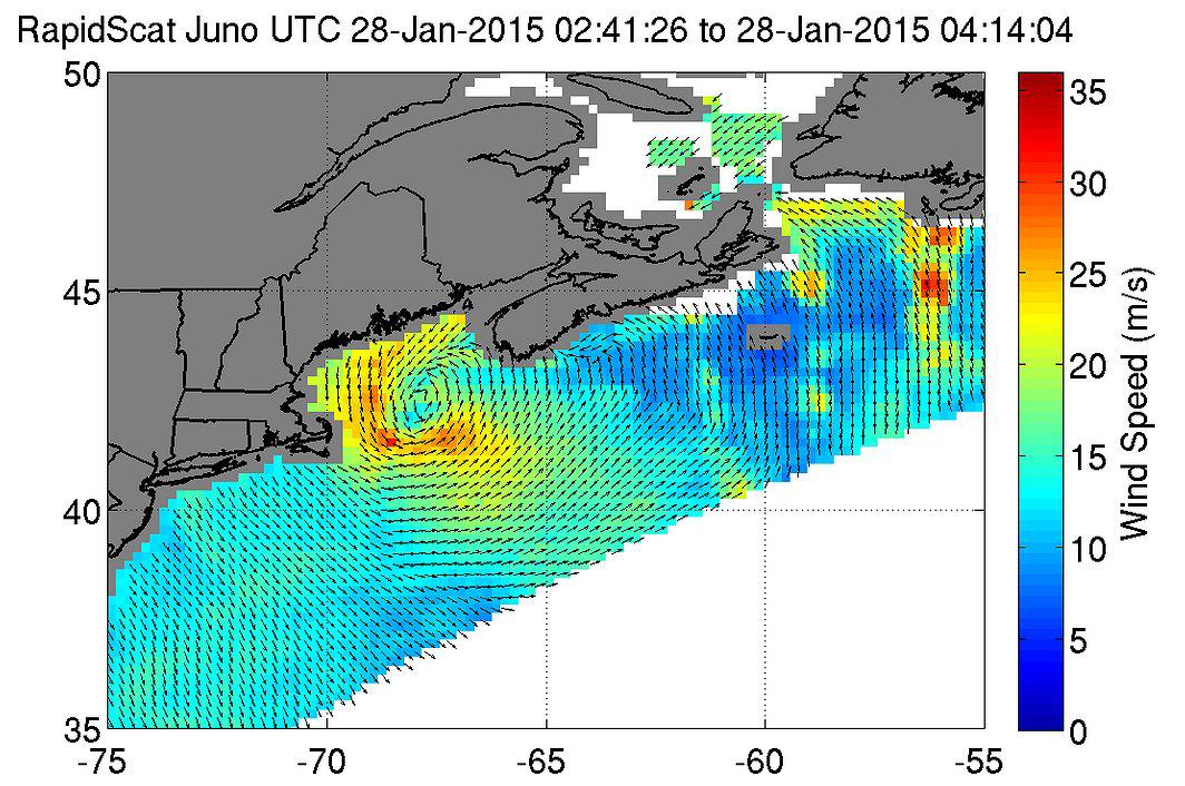
2016-01-28 |
Earth
|
RapidScat
|
ISS-RapidScat
|
682x593x3 |
|
-
PIA20372:
-
Winter Storm Winds on U.S. East Coast, as Viewed by ISS-RapidScat
Full Resolution:
TIFF
(287.4 kB)
JPEG
(85.58 kB)
|
|
|
2016-01-25 |
Earth
|
RapidScat
|
ISS-RapidScat
|
751x479x3 |
|
-
PIA20366:
-
Winter Storm Winds in Southern New Jersey, as Viewed by ISS-RapidScat
Full Resolution:
TIFF
(247.3 kB)
JPEG
(74.27 kB)
|
|
|
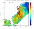
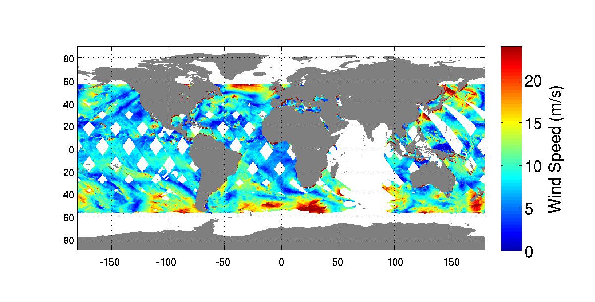
2016-01-21 |
Earth
|
RapidScat
|
ISS-RapidScat
|
1532x696x3 |
|
-
PIA20365:
-
NASA's RapidScat Observes El Niño Blowing in the Winds
Full Resolution:
TIFF
(811.4 kB)
JPEG
(252.2 kB)
|
|
|
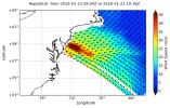
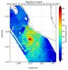
2015-11-06 |
Earth
|
RapidScat
|
ISS-RapidScat
|
2816x2134x3 |
|
-
PIA20049:
-
RapidScat and Hurricane Patricia

Full Resolution:
TIFF
(8.031 MB)
JPEG
(159.9 kB)
|
|
|
2015-10-23 |
Earth
|
RapidScat
|
ISS-RapidScat
|
584x593x3 |
|
-
PIA20031:
-
Hurricane Patricia Viewed by NASA's ISS-RapidScat
Full Resolution:
TIFF
(266.3 kB)
JPEG
(76.25 kB)
|
|
|
2015-04-21 |
Earth
|
RapidScat
|
ISS-RapidScat
|
1064x706x3 |
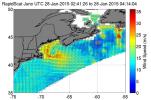
|
-
PIA18059:
-
NASA RapidScat Proving Valuable for Tropical Cyclones
Full Resolution:
TIFF
(2.255 MB)
JPEG
(187.4 kB)
|
|
|
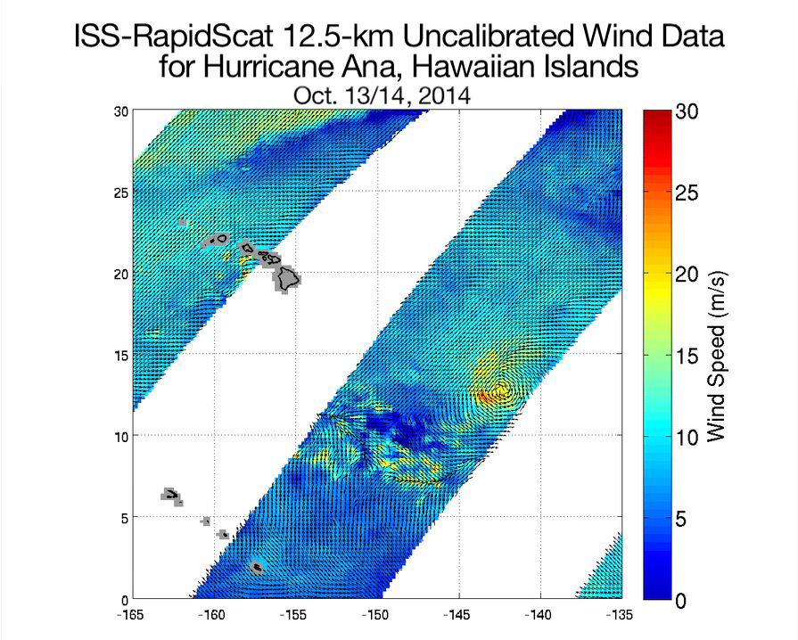
2014-10-21 |
Earth
|
RapidScat
|
ISS-RapidScat
|
895x718x3 |

|
-
PIA18834:
-
Hurricane Ana Viewed by NASA's ISS-RapidScat
Full Resolution:
TIFF
(1.929 MB)
JPEG
(136.3 kB)
|
|
|
2014-10-06 |
Earth
|
RapidScat
|
ISS-RapidScat
|
1200x609x3 |
|
-
PIA18824:
-
NASA's New RapidScat Breezes Into Operation Aboard Space Station
Full Resolution:
TIFF
(2.193 MB)
JPEG
(126 kB)
|
|
|
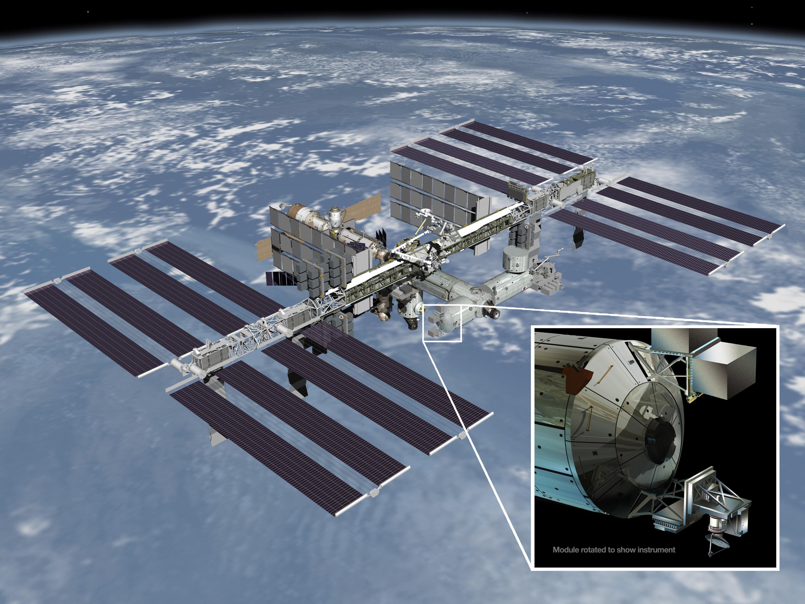
2014-01-22 |
Earth
|
RapidScat
|
ISS-RapidScat
|
2560x1920x3 |

|
-
PIA17897:
-
ISS-RapidScat
Full Resolution:
TIFF
(14.75 MB)
JPEG
(608.1 kB)
|
|
|
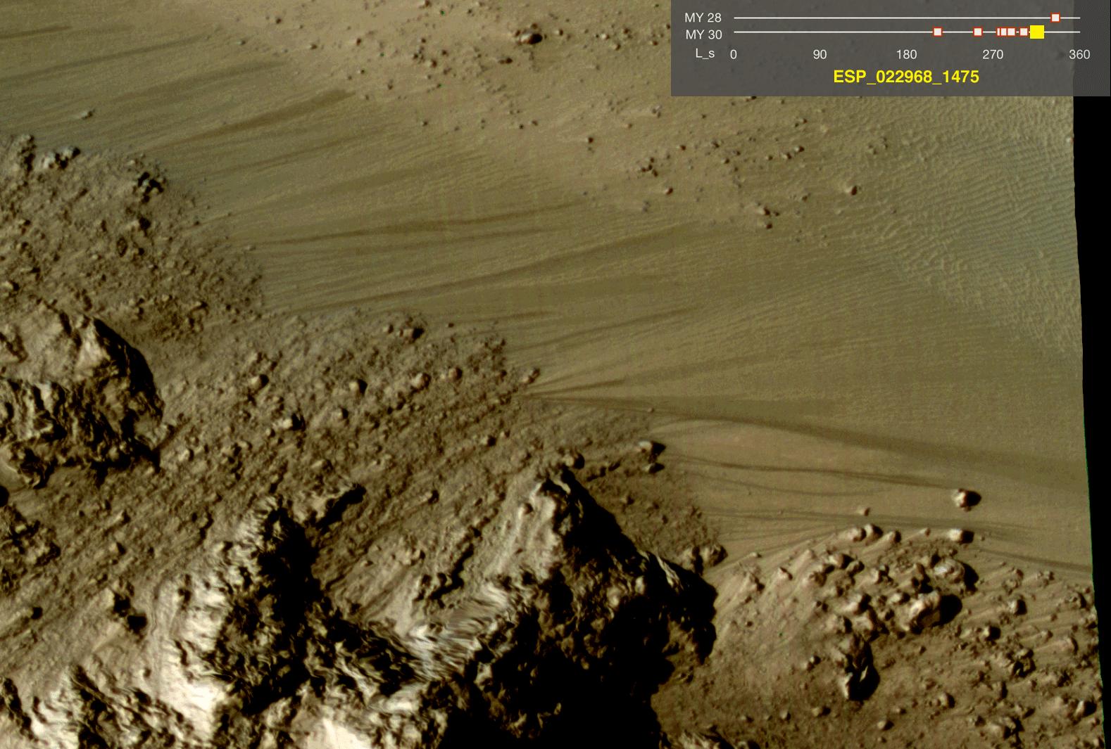
2011-08-04 |
Earth
|
Mars Reconnaissance Orbiter (MRO)
|
HiRISE
|
1578x1065x3 |

|
-
PIA14475:
-
Warm-Season Flows on Slope in Horowitz Crater (Eight-Image Sequence)
Full Resolution:
TIFF
(1.684 MB)
JPEG
(231.7 kB)
|
|
|
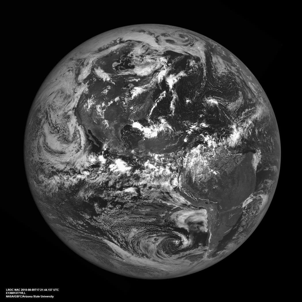
2010-09-15 |
Earth
|
Lunar Reconnaissance Orbiter (LRO)
|
Lunar Reconnaissance Orbiter Camera (NAC)
|
1050x1050x1 |
|
-
PIA13519:
-
Americas from the Moon
Full Resolution:
TIFF
(1.104 MB)
JPEG
(143.8 kB)
|
|
|
2008-09-04 |
Earth
|
ISS EarthKam
|
Electronic Still Camera
|
3060x2036x3 |
|
-
PIA11014:
-
North Island, New Zealand
Full Resolution:
TIFF
(18.69 MB)
JPEG
(1.303 MB)
|
|
|
2008-03-03 |
Earth
|
Mars Reconnaissance Orbiter (MRO)
|
HiRISE
|
800x800x3 |

|
-
PIA10244:
-
Earth and Moon as Seen from Mars
Full Resolution:
TIFF
(1.922 MB)
JPEG
(11.74 kB)
|
|
|
2005-08-22 |
Earth
|
Mars Reconnaissance Orbiter (MRO)
|
MARCI
|
700x80x1 |

|
-
PIA04160:
Calibration View of Earth and the Moon by Mars Color Imager
Full Resolution:
TIFF
(56.29 kB)
JPEG
(1.314 kB)
|
|
|
2005-08-22 |
Earth
|
Mars Reconnaissance Orbiter (MRO)
|
MARCI
|
85x75x3 |

|
-
PIA04159:
-
Calibration Image of Earth by Mars Color Imager
Full Resolution:
TIFF
(19.39 kB)
JPEG
(870)
|
 Planetary Data System


