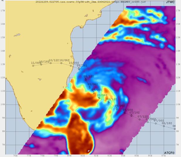
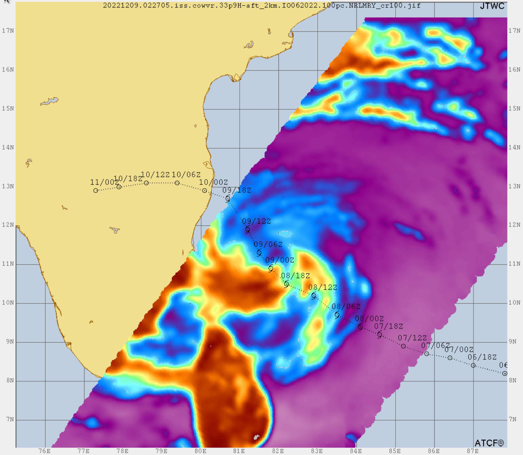
Data from two weather instruments developed at NASA's Jet Propulsion Laboratory in Southern California to provide forecasters data on weather over the open ocean were used to create this image of Tropical Cyclone Mandous on Dec. 9, 2022, as the storm approached the southeastern coast of India. Forecasters at the U.S. Joint Typhoon Warning Center in Pearl Harbor, Hawaii, used the image and others like it to understand the storm's intensity and track its path.
The instruments, Compact Ocean Wind Vector Radiometer (COWVR) and Temporal Experiment for Storms and Tropical Systems (TEMPEST), observe the planet's atmosphere and surface from aboard the International Space Station.
The image above uses 33.9 gigahertz microwave emissions measured from COWVR to detect structural features of Mandous, including its center, which is about 160 miles (250 kilometers) northeast of the northern tip of Sri Lanka. The colored portions over water indicate the presence of precipitation, with yellow and orange indicating where the storm is strongest, while blue shows where it's weakest.
COWVR and TEMPEST sent the data for this image back to Earth in a direct stream via NASA's tracking and data relay satellite (TDRS) constellation. The data was processed at JPL, and meteorologists at the U.S. Naval Research Laboratory in Monterey, California, created the image, which they shared with the Joint Typhoon Warning Center.
About the size of a minifridge, COWVR measures natural microwave emissions over the ocean. The magnitude of the emissions increases with the amount of rain in the atmosphere. TEMPEST – comparable in size to a cereal box – tracks microwaves at a much shorter wavelength, allowing it to detect atmospheric water vapor.
Both microwave radiometers were conceived to demonstrate that smaller, more energy-efficient, more simply designed sensors can perform most of the same measurements as current space-based weather instruments that are heavier, consume more power, and cost much more to construct.
COWVR's development was funded by the U.S. Space Force, and TEMPEST was developed with NASA funding. The U.S. Space Test Program-Houston 8 (STP-H8) is responsible for hosting the instruments on the space station under Space Force funding in partnership with NASA. Data from the instruments is being used by government and university weather forecasters and scientists. The mission will inform development of future space-based weather sensors, and scientists are working on mission concepts that would take advantage of the low-cost microwave sensor technologies to study long-standing questions, such as how heat from the ocean fuels global weather patterns.
 Planetary Data System


