|
Your search criteria found 12735 images Target is Mars (and available satellites) |
| My List |
Addition Date
|
Target | Mission | Instrument | Size |

|
1997-10-13 | Mars |
Mars Pathfinder (MPF) |
Imager for Mars Pathfinder |
450x227x1 |
|
|||||
|
|
1997-10-13 | Mars |
Mars Pathfinder (MPF) |
Imager for Mars Pathfinder |
480x244x1 |

|
|||||
|
|
1997-10-13 | Mars |
Mars Pathfinder (MPF) |
Imager for Mars Pathfinder |
486x248x1 |
|
|||||
|
|
1997-10-13 | Mars |
Mars Global Surveyor (MGS) |
Magnetometer |
762x609x3 |
|
|||||
|
|
1997-10-13 | Mars |
Mars Global Surveyor (MGS) |
Magnetometer |
861x689x3 |

|
|||||
|
|
1997-10-13 | Mars |
Mars Global Surveyor (MGS) |
Magnetometer |
905x723x3 |
|
|||||
|
|
1997-10-13 | Mars |
Mars Global Surveyor (MGS) |
Magnetometer |
715x572x3 |
|
|||||
|
|
1997-10-13 | Mars |
Mars Global Surveyor (MGS) |
MOLA |
2550x3300x3 |
|
|||||
|
|
1997-10-13 | Mars |
Mars Global Surveyor (MGS) |
MOLA |
3300x1634x3 |

|
|||||
|
|
1997-10-13 | Mars |
Mars Global Surveyor (MGS) |
MOLA |
3300x2550x3 |
|
|||||
|
|
1997-10-13 | Mars |
Mars Global Surveyor (MGS) |
MOLA |
3300x2550x3 |
|
|||||
|
|
1997-10-14 | Mars |
Mars Pathfinder (MPF) |
Deep Space Network |
731x553x3 |
|
|||||
|
|
1997-10-14 | Mars |
Mars Pathfinder (MPF) |
Deep Space Network |
731x553x3 |

|
|||||
|
|
1997-10-14 | Mars |
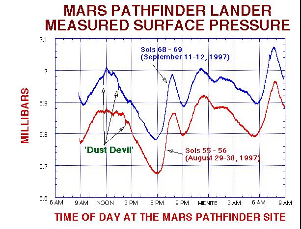
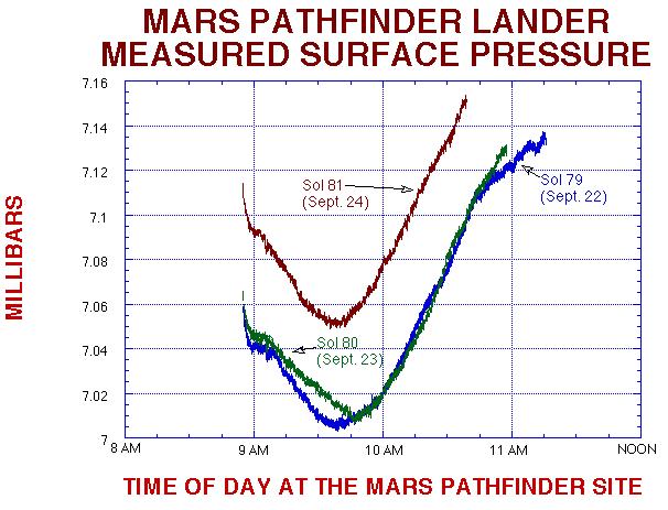
Mars Pathfinder (MPF) |
Atmospheric Structure / Meteorology Instrument |
613x467x3 |
|
|||||
|
|
1997-10-14 | Mars |
Mars Pathfinder (MPF) |
Atmospheric Structure / Meteorology Instrument |
606x463x3 |
|
|||||
|
|
1997-10-14 | Mars |
Mars Pathfinder (MPF) |
Atmospheric Structure / Meteorology Instrument |
605x458x3 |
|
|||||
|
|
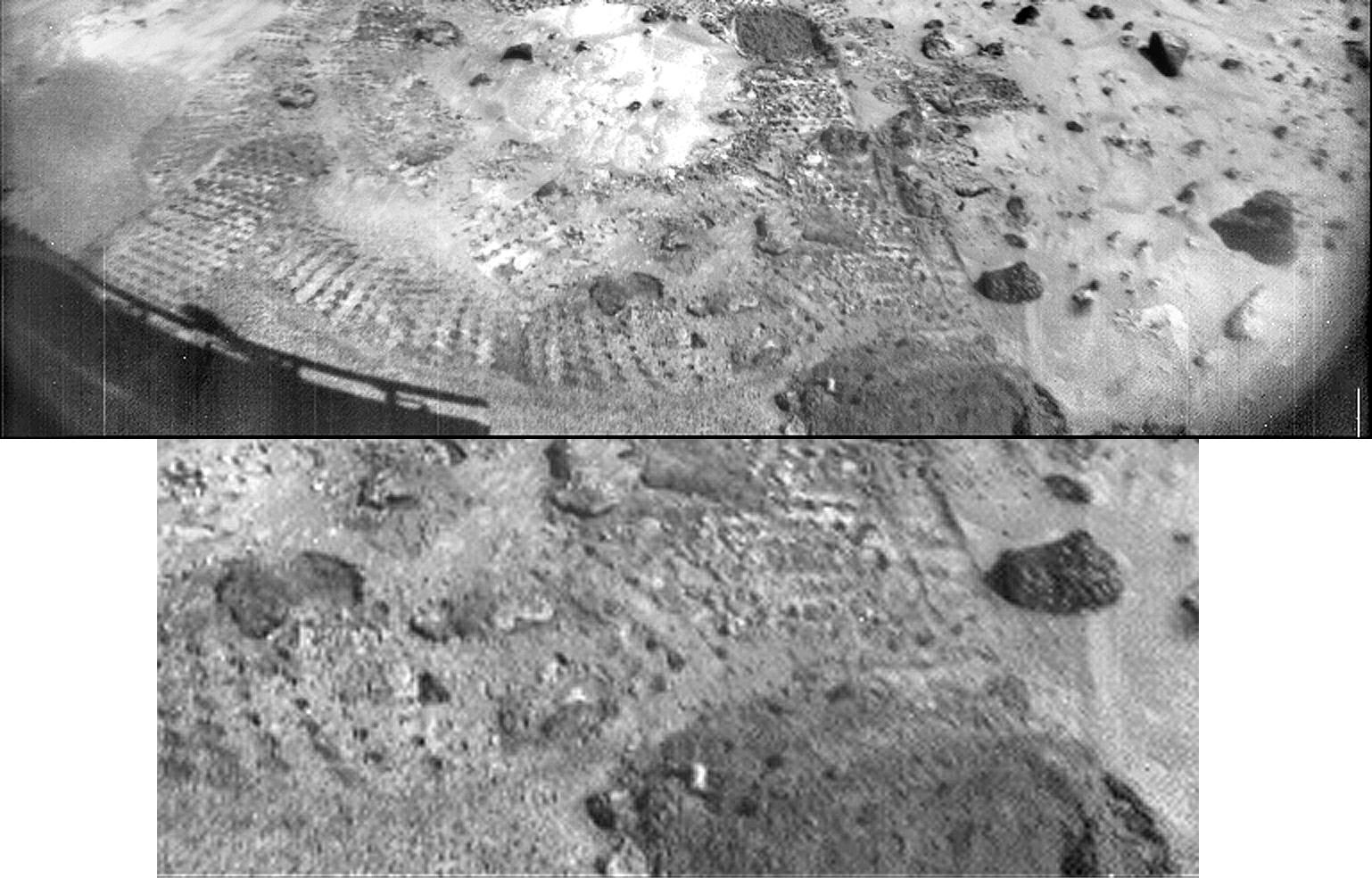
1997-10-14 | Mars |
Mars Pathfinder (MPF) |
Rover Cameras |
1538x984x1 |
|
|||||
|
|
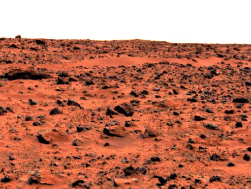
1997-10-14 | Mars |
Mars Pathfinder (MPF) |
Imager for Mars Pathfinder |
510x385x3 |
|
|||||
|
|
1997-10-14 | Mars |
Mars Pathfinder (MPF) |
Rover Cameras |
383x472x1 |
|
|||||
|
|
1997-10-14 | Mars |
Mars Pathfinder (MPF) |
Imager for Mars Pathfinder |
641x678x3 |

|
|||||
|
|
1997-10-14 | Mars |
Mars Pathfinder (MPF) |
Imager for Mars Pathfinder |
446x218x1 |

|
|||||
|
|
1997-10-14 | Mars |
Mars Pathfinder (MPF) |
Imager for Mars Pathfinder |
256x248x3 |
|
|||||
|
|
1997-10-14 | Mars |
Mars Pathfinder (MPF) |
Imager for Mars Pathfinder |
900x900x3 |
|
|||||
|
|
1997-10-14 | Mars |
Mars Pathfinder (MPF) |
Imager for Mars Pathfinder |
1277x1239x3 |
|
|||||
|
|
1997-10-14 | Mars |
Mars Pathfinder (MPF) |
Rover Cameras |
383x380x1 |
|
|||||
|
|
1997-10-14 | Mars |
Mars Pathfinder (MPF) |
Imager for Mars Pathfinder |
1050x1140x3 |
|
|||||
|
|
1997-10-14 | Mars |
Mars Pathfinder (MPF) |
Rover Cameras |
413x399x1 |
|
|||||
|
|
1997-10-14 | Mars |
Mars Pathfinder (MPF) |
Imager for Mars Pathfinder |
256x248x1 |
|
|||||
|
|
1997-10-14 | Mars |
Mars Pathfinder (MPF) |
Imager for Mars Pathfinder |
256x248x3 |

|
|||||
|
|
1997-10-14 | Mars |
Mars Pathfinder (MPF) |
Imager for Mars Pathfinder |
256x248x3 |
|
|||||
|
|
1997-10-14 | Mars |
Mars Pathfinder (MPF) |
Rover Cameras |
593x446x1 |
|
|||||
|
|
1997-10-14 | Mars |
Mars Pathfinder (MPF) |
Rover Cameras |
523x475x1 |
|
|||||
|
|
1997-10-14 | Mars |
Mars Pathfinder (MPF) Viking |
216x224x1 | |
|
|||||
|
|
1997-10-15 | Mars |
Mars Global Surveyor (MGS) |
Mars Orbiter Camera (MOC) |
928x1552x3 |

|
|||||
|
|
1997-10-15 | Mars |
Mars Global Surveyor (MGS) |
Mars Orbiter Camera (MOC) |
1023x608x3 |
|
|||||
|
|
1997-10-17 | Mars |
Mars Pathfinder (MPF) |
Imager for Mars Pathfinder |
640x480x3 |
|
|||||
|
|
1997-11-04 | Mars |
Mars Pathfinder (MPF) |
Imager for Mars Pathfinder |
6283x1090x3 |
|
|||||
|
|
1997-11-04 | Mars |
Mars Pathfinder (MPF) |
Imager for Mars Pathfinder |
4214x888x3 |
|
|||||
|
|
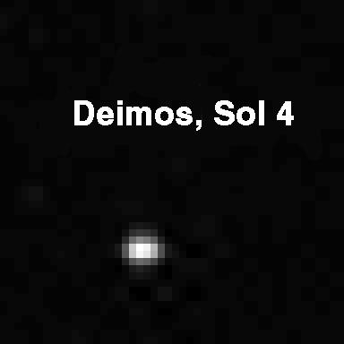
1997-11-04 | Deimos |
Mars Pathfinder (MPF) |
Imager for Mars Pathfinder |
384x384x1 |

|
|||||
|
|
1997-11-04 | Phobos |
Mars Pathfinder (MPF) |
Imager for Mars Pathfinder |
384x384x1 |
|
|||||
|
|
1997-11-04 | Mars |
Mars Pathfinder (MPF) |
Rover Cameras |
768x481x1 |

|
|||||
|
|
1997-11-04 | Mars |
Mars Pathfinder (MPF) |
Imager for Mars Pathfinder |
4204x1317x3 |
|
|||||
|
|
1997-11-04 | Mars |
Mars Pathfinder (MPF) |
Imager for Mars Pathfinder |
4375x1533x1 |
|
|||||
|
|
1997-11-04 | Mars |
Mars Pathfinder (MPF) |
Imager for Mars Pathfinder |
4214x887x1 |
|
|||||
|
|
1997-11-04 | Mars |
Mars Pathfinder (MPF) |
Imager for Mars Pathfinder |
1726x1090x3 |
|
|||||
|
|
1997-11-04 | Mars |
Mars Pathfinder (MPF) |
Imager for Mars Pathfinder |
2128x1090x3 |
|
|||||
|
|
1997-11-04 | Mars |
Mars Pathfinder (MPF) |
Imager for Mars Pathfinder |
2094x1090x3 |
|
|||||
|
|
1997-11-04 | Mars |
Mars Pathfinder (MPF) |
Imager for Mars Pathfinder |
6283x1090x3 |
|
|||||
|
|
1997-11-04 | Mars |
Mars Pathfinder (MPF) |
Imager for Mars Pathfinder |
528x901x3 |
|
|||||
|
|
1997-11-04 | Mars |
Mars Pathfinder (MPF) |
Imager for Mars Pathfinder |
6141x1189x3 |
|
|||||
|
|
1997-11-04 | Mars |
Mars Pathfinder (MPF) |
Imager for Mars Pathfinder |
6141x1189x1 |

|
|||||
|
|
1997-11-10 | Mars |
Mars Global Surveyor (MGS) |
MOLA |
3300x2550x3 |
|
|||||
|
|
1997-11-10 | Mars |
Mars Global Surveyor (MGS) |
MOLA |
3300x2550x3 |
|
|||||
|
|
1997-11-10 | Mars |
Mars Global Surveyor (MGS) |
MOLA |
3300x2550x3 |
|
|||||
|
|
1997-11-10 | Mars |
Mars Global Surveyor (MGS) |
MOLA |
3300x2550x3 |
|
|||||
|
|
1997-11-10 | Mars |
Mars Global Surveyor (MGS) |
MOLA |
3300x2550x3 |
|
|||||
|
|
1997-11-10 | Mars |
Mars Global Surveyor (MGS) |
MOLA |
3300x2550x3 |
|
|||||
|
|
1997-11-10 | Mars |
Mars Global Surveyor (MGS) |
Magnetometer |
996x746x3 |
|
|||||
|
|
1997-11-10 | Mars |
Mars Global Surveyor (MGS) |
Magnetometer |
972x744x3 |
|
|||||
|
|
1997-11-10 | Mars |
Mars Global Surveyor (MGS) |
Thermal Emission Spectrometer |
1409x1091x3 |
|
|||||
|
|
1997-11-10 | Mars |
Mars Global Surveyor (MGS) |
Thermal Emission Spectrometer |
1872x1224x3 |

|
|||||
|
|
1997-11-10 | Mars |
Mars Global Surveyor (MGS) |
Thermal Emission Spectrometer |
1400x1000x3 |
|
|||||
|
|
1997-11-10 | Mars |
Mars Global Surveyor (MGS) |
Thermal Emission Spectrometer |
524x424x3 |
|
|||||
|
|
1997-11-10 | Mars |
Mars Global Surveyor (MGS) |
Mars Orbiter Camera (MOC) |
2880x2880x1 |
|
|||||
|
|
1997-11-10 | Mars |
Mars Global Surveyor (MGS) |
Mars Orbiter Camera (MOC) |
1024x1728x1 |
|
|||||
|
|
1997-11-10 | Mars |
Mars Global Surveyor (MGS) |
Mars Orbiter Camera (MOC) |
1706x1280x1 |
|
|||||
|
|
1997-11-10 | Mars |
Mars Global Surveyor (MGS) |
Mars Orbiter Camera (MOC) |
2023x996x1 |
|
|||||
|
|
1997-11-10 | Mars |
Mars Global Surveyor (MGS) |
Mars Orbiter Camera (MOC) |
1024x2688x1 |
|
|
|||||
|
|
1997-11-10 | Mars |
Mars Global Surveyor (MGS) |
Mars Orbiter Camera (MOC) |
2048x2048x1 |
|
|||||
|
|
1997-11-10 | Mars |
Mars Global Surveyor (MGS) |
Mars Orbiter Camera (MOC) |
1640x900x1 |
|
|||||
|
|
1997-11-10 | Mars |
Mars Global Surveyor (MGS) |
Mars Orbiter Camera (MOC) |
512x1280x1 |
|
|
|||||
|
|
1997-11-10 | Mars |
Mars Global Surveyor (MGS) |
Mars Orbiter Camera (MOC) |
512x1280x1 |
|
|
|||||
|
|
1997-11-10 | Mars |
Mars Global Surveyor (MGS) |
Mars Orbiter Camera (MOC) |
1280x960x1 |

|
|||||
|
|
1997-12-12 | Mars |
Mars Pathfinder (MPF) |
Imager for Mars Pathfinder |
2550x3282x3 |
|
|||||
|
|
1997-12-12 | Mars |
Mars Pathfinder (MPF) |
Imager for Mars Pathfinder |
1276x1175x3 |
|
|||||
|
|
1997-12-12 | Mars |
Mars Pathfinder (MPF) |
Imager for Mars Pathfinder |
1784x1271x3 |
|
|||||
|
|
1997-12-12 | Mars |
Mars Pathfinder (MPF) |
Imager for Mars Pathfinder |
1506x1415x3 |
|
|||||
|
|
1997-12-12 | Mars |
Mars Pathfinder (MPF) |
Rover Cameras |
411x190x1 |

|
|||||
|
|
1998-01-07 | Mars |
Mars Pathfinder (MPF) |
Imager for Mars Pathfinder |
288x288x3 |
|
|||||
|
|
1998-01-07 | Mars |
Mars Pathfinder (MPF) |
Rover Cameras |
288x288x1 |
|
|||||
|
|
1998-01-07 | Mars |
Mars Pathfinder (MPF) |
Rover Cameras |
370x288x1 |
|
|||||
|
|
1998-01-07 | Mars |
Mars Pathfinder (MPF) |
Rover Cameras |
370x288x1 |
|
|||||
|
|
1998-01-07 | Mars |
Mars Pathfinder (MPF) |
Rover Cameras |
288x288x1 |

|
|||||
|
|
1998-01-07 | Mars |
Mars Pathfinder (MPF) |
Rover Cameras |
288x288x1 |

|
|||||
|
|
1998-01-07 | Mars |
Mars Pathfinder (MPF) |
Rover Cameras |
288x288x1 |

|
|||||
|
|
1998-01-07 | Mars |
Mars Pathfinder (MPF) |
Rover Cameras |
288x288x1 |
|
|||||
|
|
1998-02-12 | Mars |
Mars Global Surveyor (MGS) |
Mars Orbiter Camera (MOC) |
1100x1100x3 |
|
|||||
|
|
1998-02-12 | Mars |
Mars Global Surveyor (MGS) |
Mars Orbiter Camera (MOC) |
1536x2304x1 |
|
|||||
|
|
1998-02-12 | Mars |
Mars Global Surveyor (MGS) |
Mars Orbiter Camera (MOC) |
295x4988x1 |
|
|
|||||
|
|
1998-02-12 | Mars |
Mars Global Surveyor (MGS) |
Mars Orbiter Camera (MOC) |
2048x2304x1 |
|
|||||
|
|
1998-02-12 | Mars |
Mars Global Surveyor (MGS) |
Mars Orbiter Camera (MOC) |
1024x2688x1 |
|
|
|||||
|
|
1998-02-12 | Mars |
Mars Global Surveyor (MGS) |
Mars Orbiter Camera (MOC) |
1536x2304x1 |
|
|||||
|
|
1998-02-12 | Mars |
Mars Global Surveyor (MGS) |
Mars Orbiter Camera (MOC) |
1024x6144x1 |
|
|
|||||
|
|
1998-02-12 | Mars |
Mars Global Surveyor (MGS) |
Mars Orbiter Camera (MOC) |
1536x2304x1 |

|
|||||
|
|
1998-02-12 | Mars |
Mars Global Surveyor (MGS) |
Mars Orbiter Camera (MOC) |
1024x6378x1 |
|
|
|||||
|
|
1998-02-12 | Mars |
Mars Global Surveyor (MGS) |
Mars Orbiter Camera (MOC) |
3500x2000x1 |
|
|||||
|
|
1998-02-12 | Mars |
Mars Global Surveyor (MGS) |
Mars Orbiter Camera (MOC) |
2048x3591x1 |
|
|||||
|
|
1998-02-12 | Mars |
Mars Global Surveyor (MGS) |
Mars Orbiter Camera (MOC) |
2254x2000x1 |
|
|||||
|
|
1998-02-12 | Mars |
Mars Global Surveyor (MGS) |
Mars Orbiter Camera (MOC) |
1024x1920x1 |

|
|||||
|
|
1998-02-12 | Mars |
Mars Global Surveyor (MGS) |
Mars Orbiter Camera (MOC) |
2048x2048x1 |

|
|||||

|
 |
|
 |
 |
|
|
|
|
|
|

|
| 1-100 | 101-200 | 201-300 | 301-400 | 401-500 | 501-600 | 601-700 | 701-800 | 801-900 | 901-1000 |
| Currently displaying images: 241 - 340 of 12735 |