My
List |
Addition Date
|
Target
|
Mission
|
Instrument
|
Size
|

|
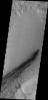
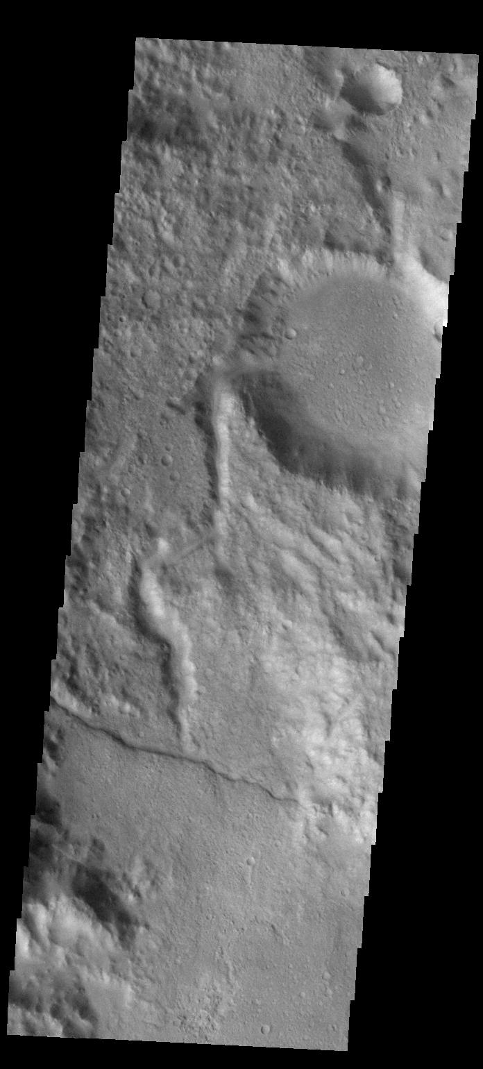
2013-04-10 |
Mars
|
Mars Reconnaissance Orbiter (MRO)
|
HiRISE
|
2560x1920x3 |
|
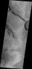
-
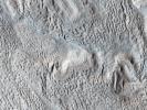
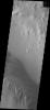
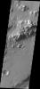
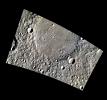
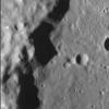
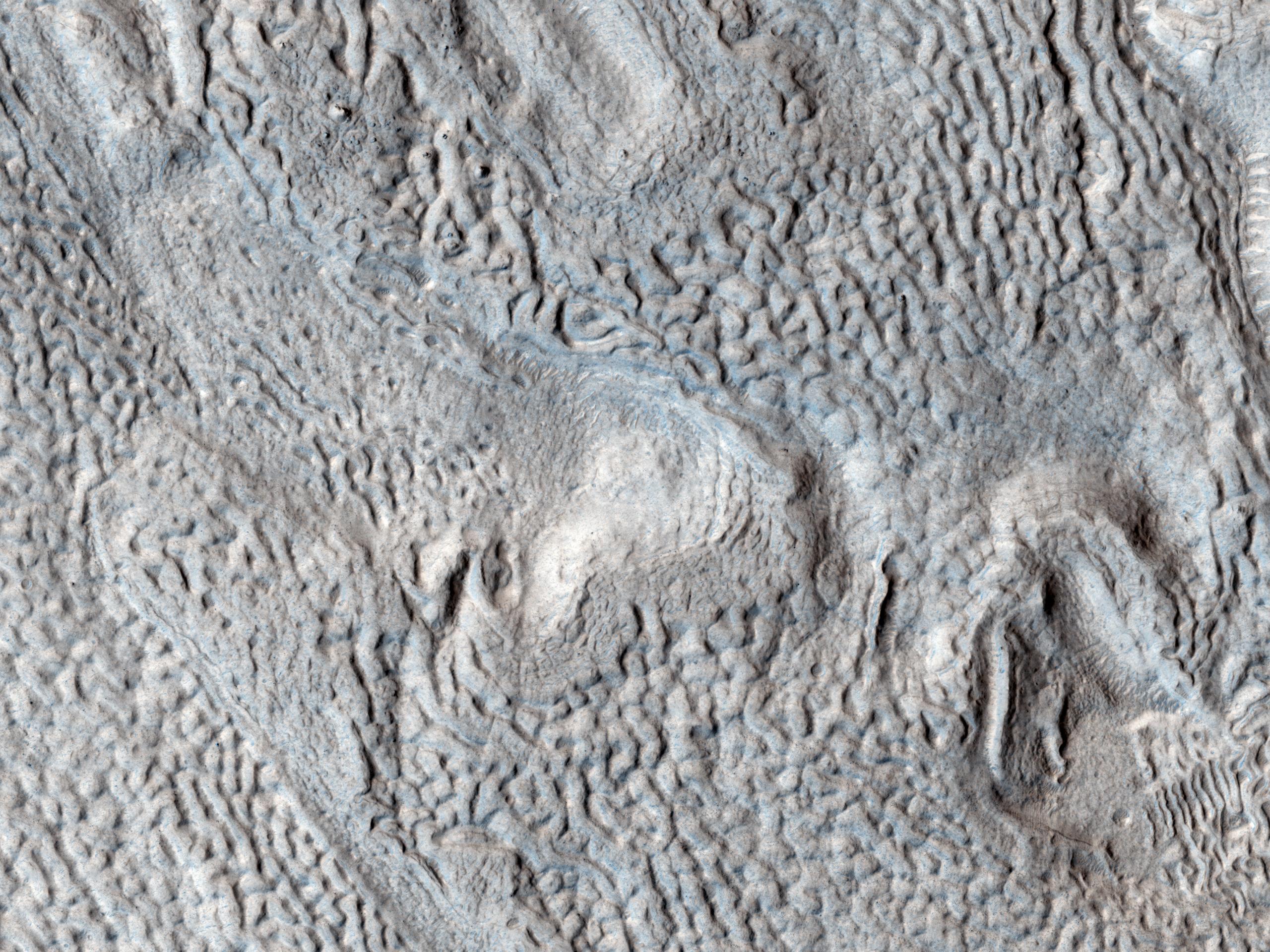
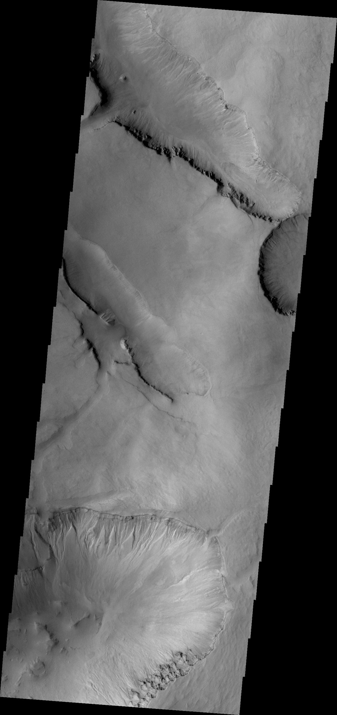
PIA17880:
-
Ridges and Grooves That Wave and Buckle on a Valley Floor
Full Resolution:
TIFF
(14.75 MB)
JPEG
(905.8 kB)
|
|
|
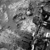
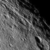
2013-04-10 |
Mars
|
Mars Reconnaissance Orbiter (MRO)
|
HiRISE
|
2560x1920x3 |

|
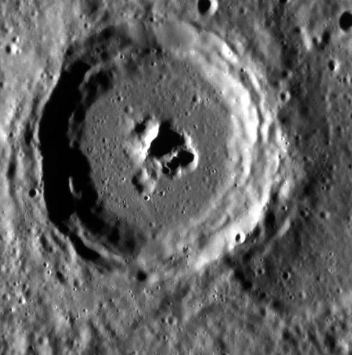
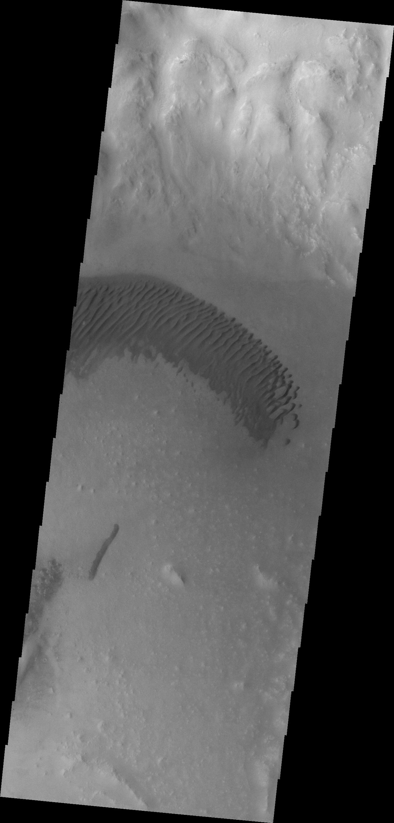
-
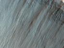
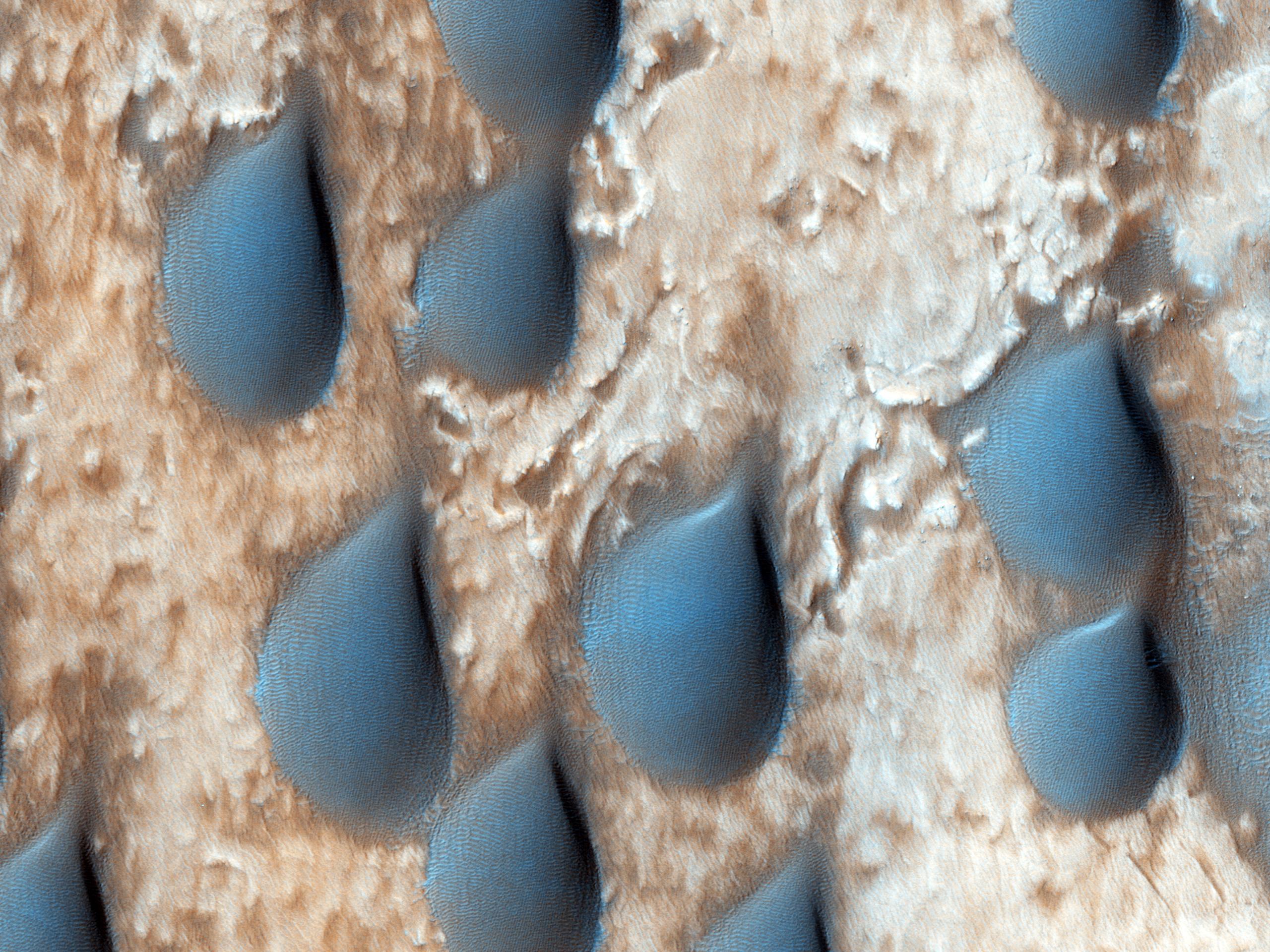
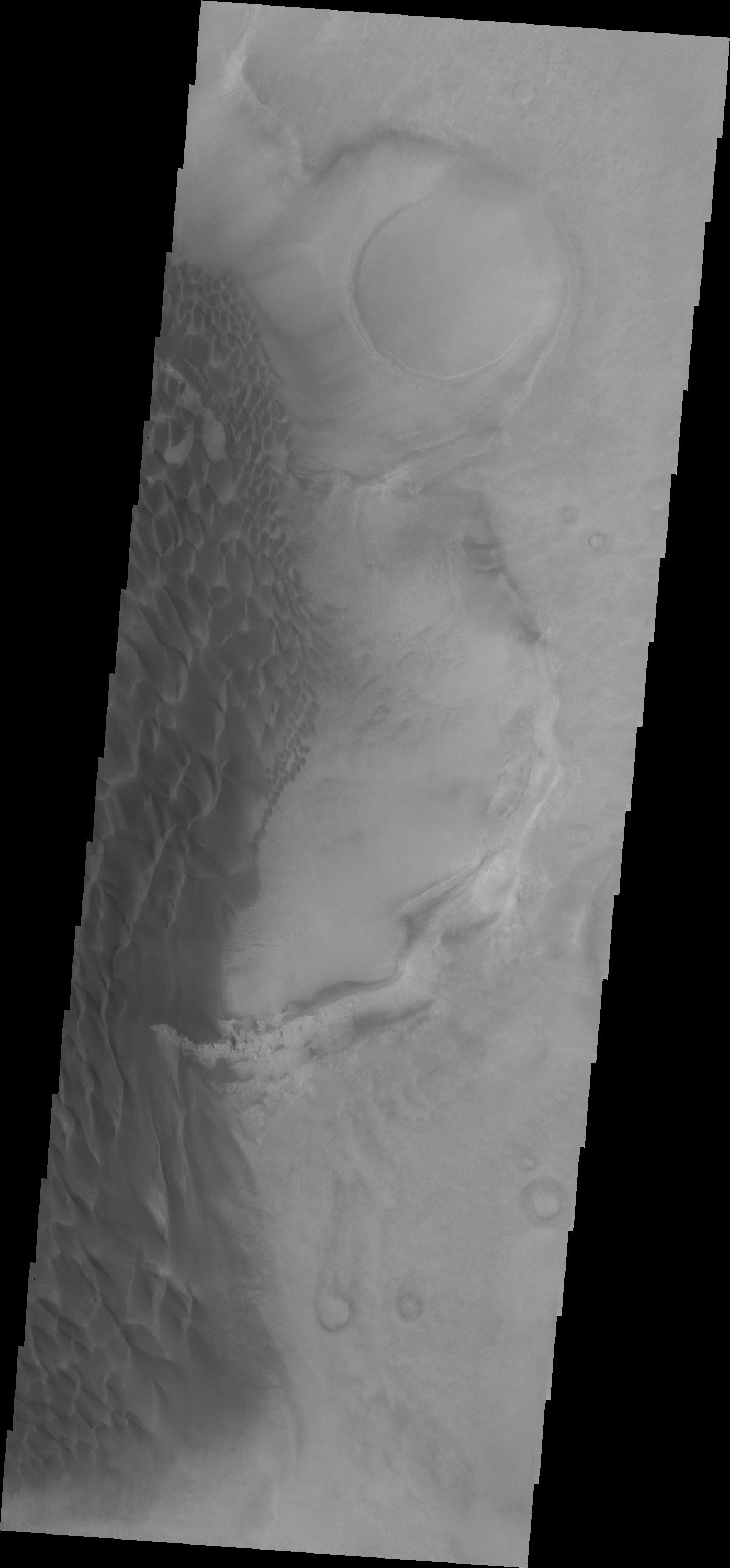
PIA17879:
-
Raindrops of Sand in Copernicus Crater
Full Resolution:
TIFF
(14.75 MB)
JPEG
(787.4 kB)
|
|
|
2013-04-10 |
Mars
|
Mars Reconnaissance Orbiter (MRO)
|
HiRISE
|
2560x1920x3 |
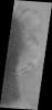
|
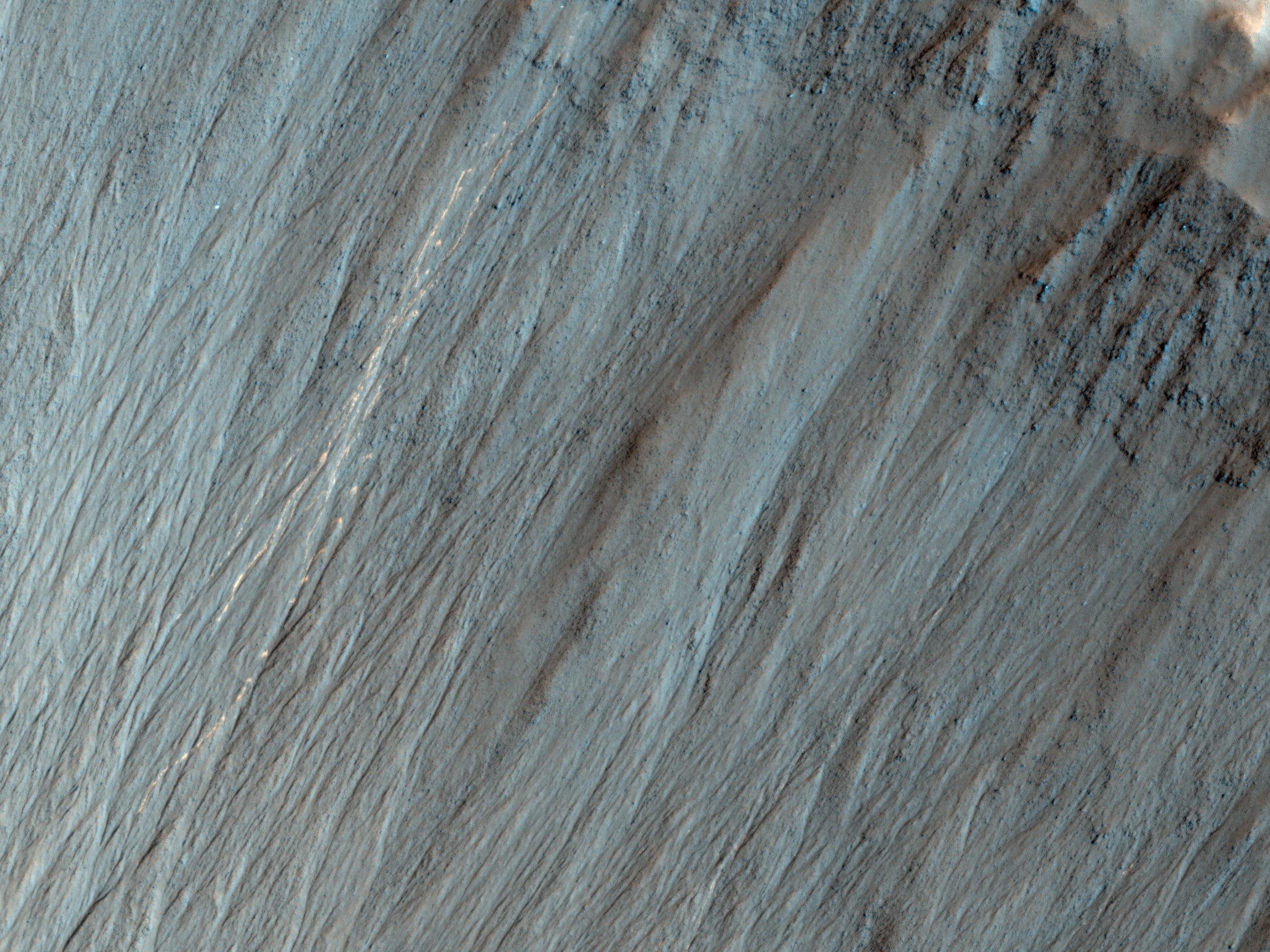
-
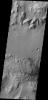
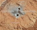
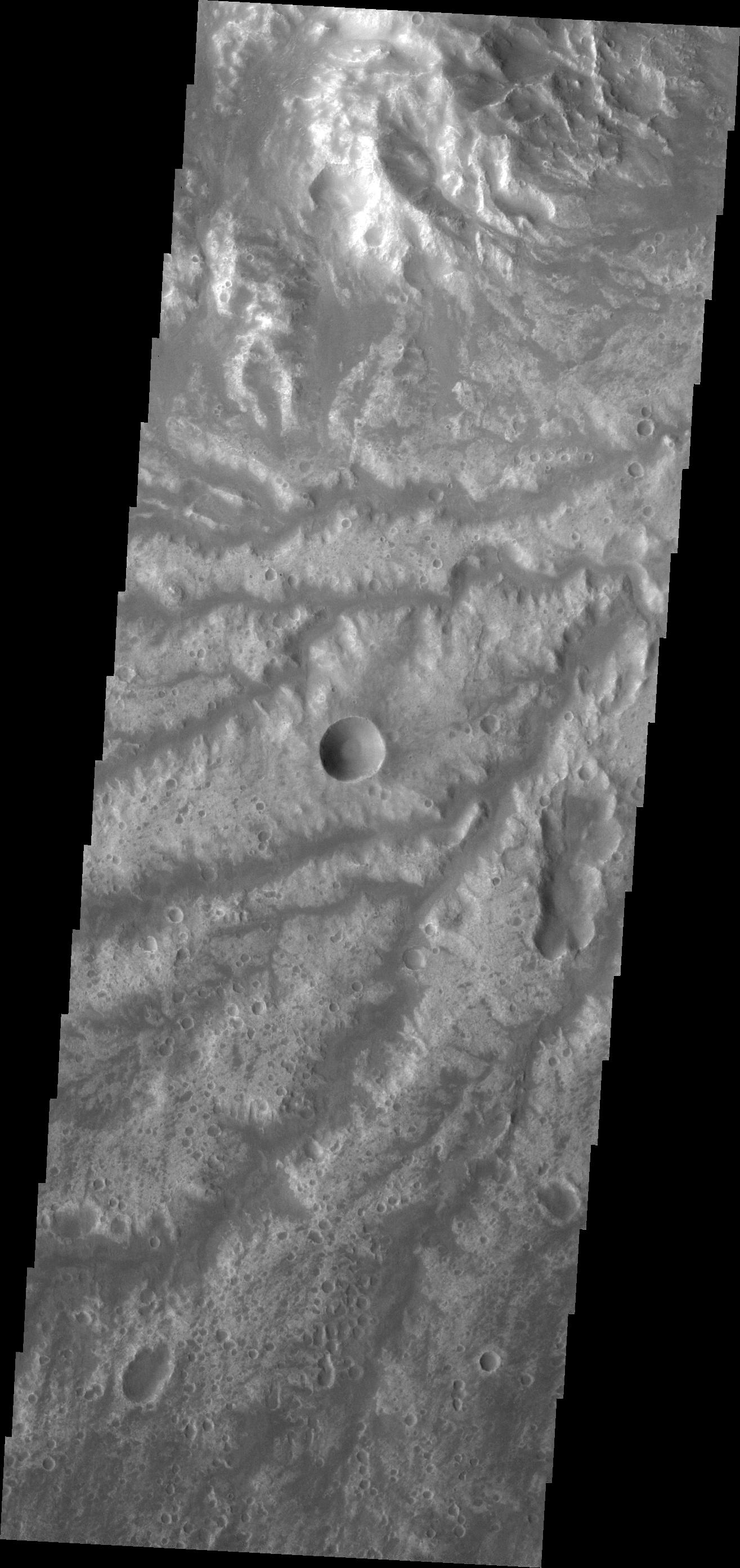
PIA17878:
-
Bright Tracks from Bouncing and Rolling Boulders
Full Resolution:
TIFF
(14.75 MB)
JPEG
(905 kB)
|
|
|
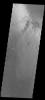
2013-04-10 |
Saturn
|
Cassini-Huygens
|
|
4465x4115x3 |
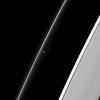
|
-
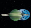
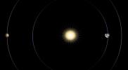
PIA16842:
-
Saturn's Ring 'Rain' (Artist Concept)
Full Resolution:
TIFF
(55.15 MB)
JPEG
(717.3 kB)
|
|
|
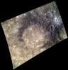
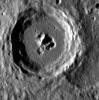
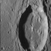
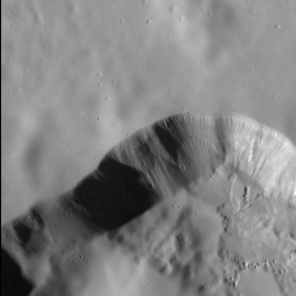
2013-04-10 |
Mercury
|
MESSENGER
|
MDIS - Narrow Angle
|
1282x2580x1 |

|
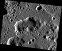
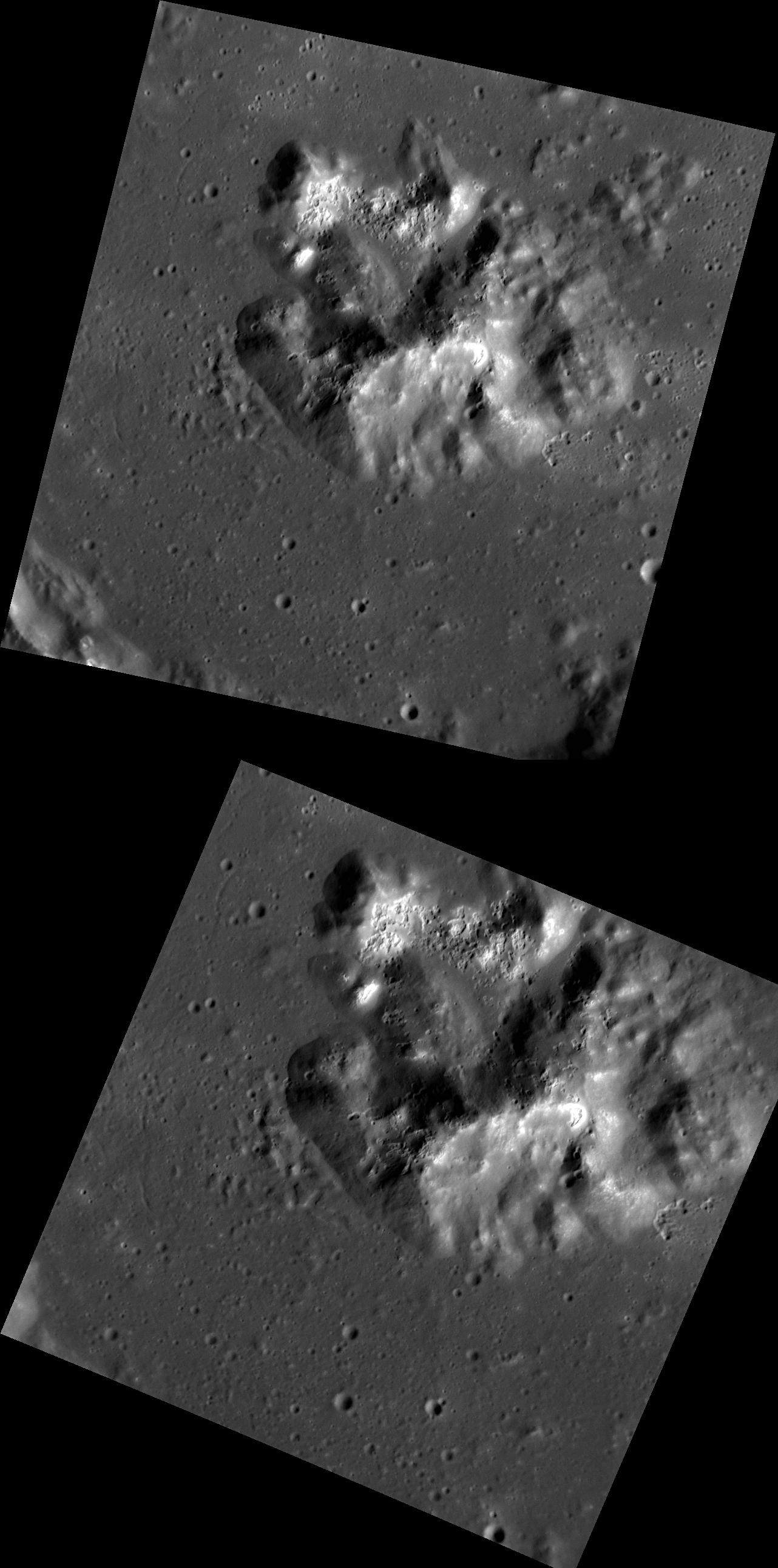
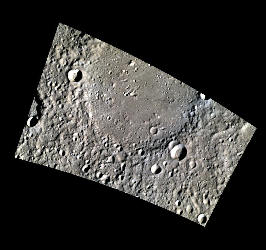
-
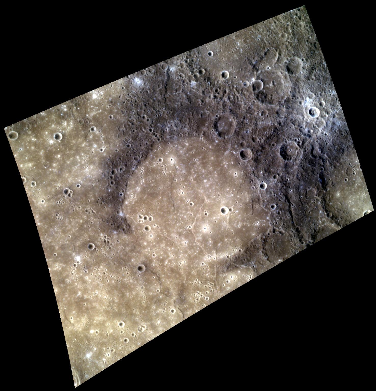
PIA16952:
-
A Mountain of Hollows
Full Resolution:
TIFF
(3.311 MB)
JPEG
(266.1 kB)
|
|
|
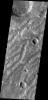
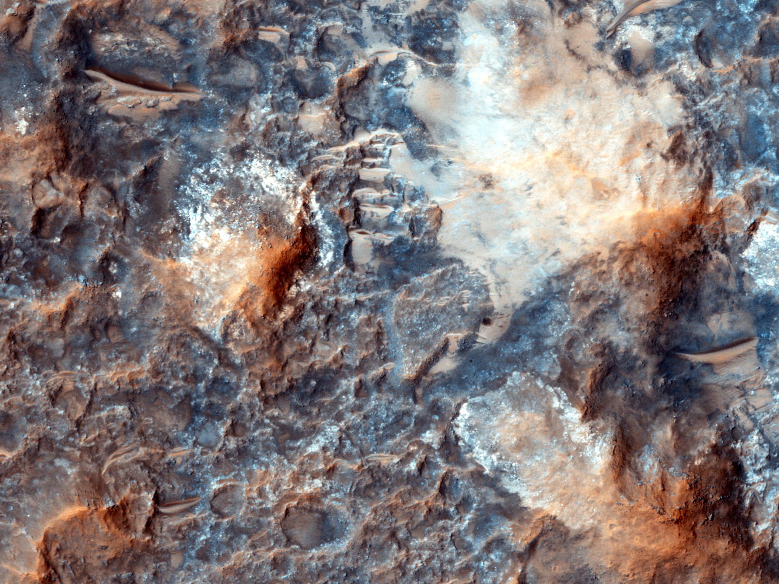
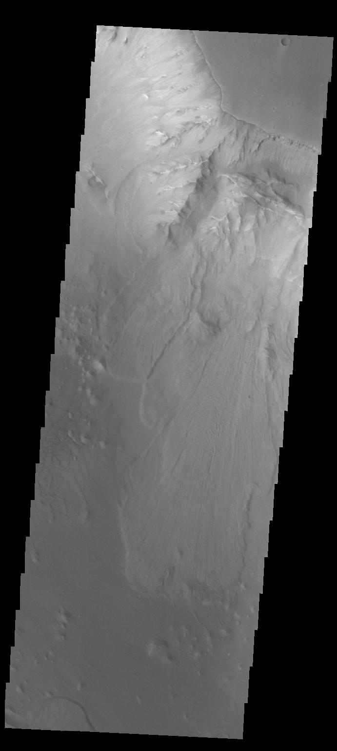
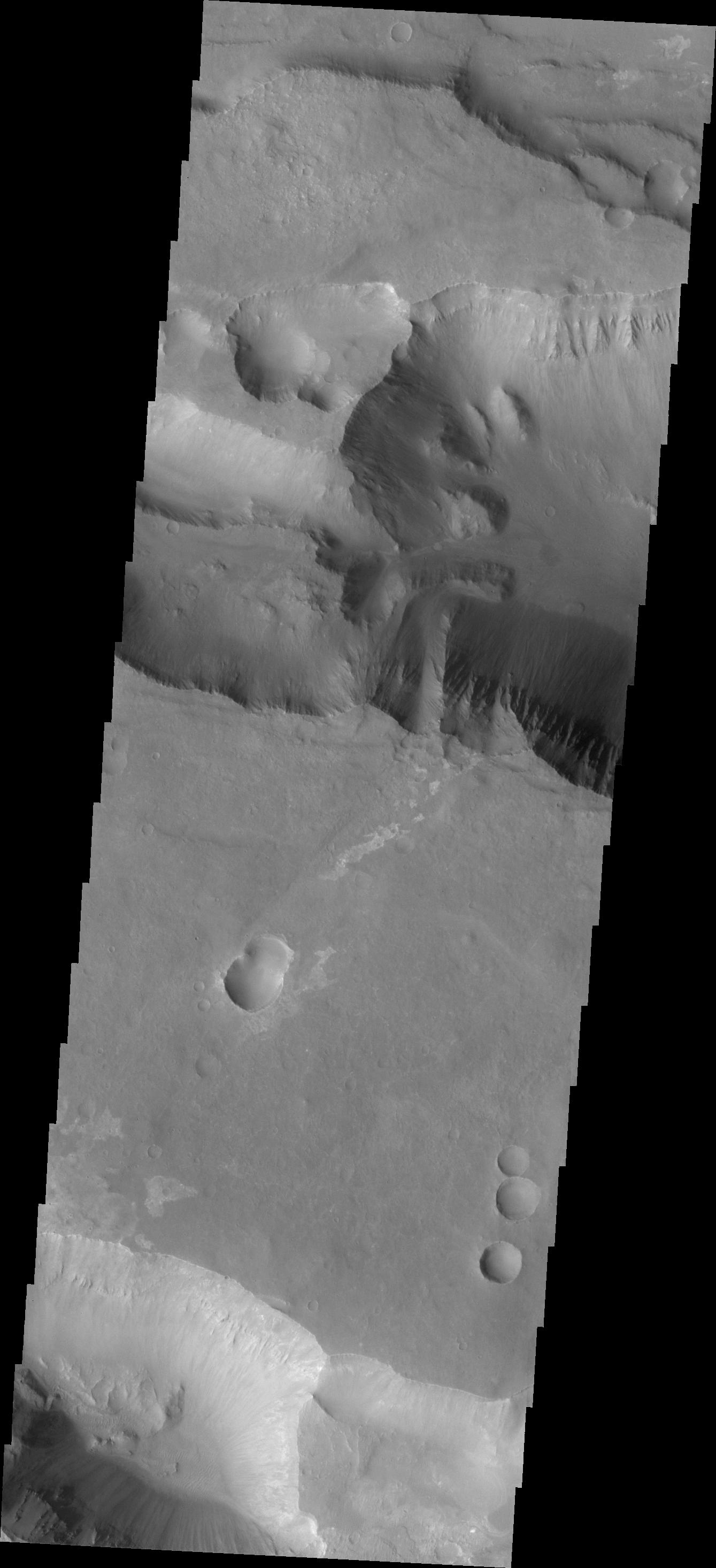
2013-04-10 |
Mars
|
Mars Reconnaissance Orbiter (MRO)
|
HiRISE
|
2560x1920x3 |
|
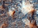
-
PIA17877:
-
Megabreccia on the Floor of an Impact Crater
Full Resolution:
TIFF
(14.75 MB)
JPEG
(747.9 kB)
|
|
|
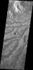
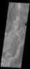
2013-04-10 |
Mars
|
2001 Mars Odyssey
|
THEMIS
|
1352x2922x1 |
|
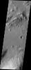
-
PIA16244:
-
Images of Gale #6
Full Resolution:
TIFF
(3.955 MB)
JPEG
(199.5 kB)
|
|
|
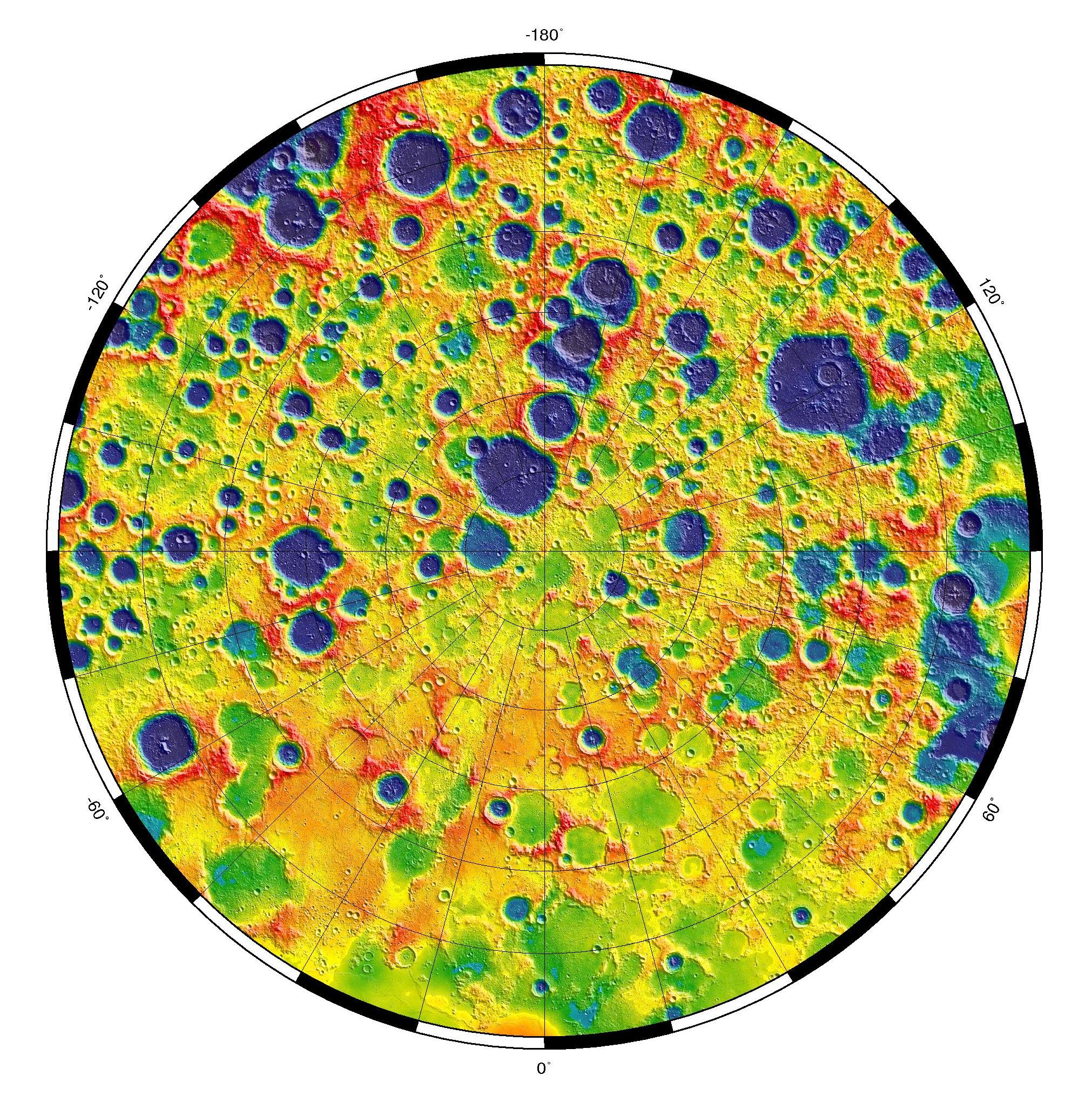
2013-04-09 |
Mercury
|
MESSENGER
|
MLA
|
1082x1082x3 |
|
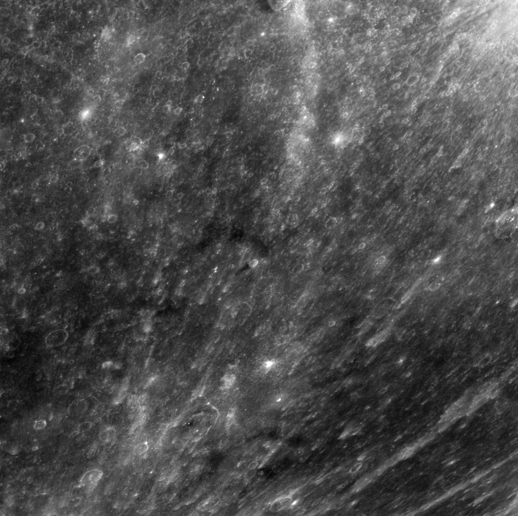
-
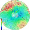
PIA16951:
-
Northern Topography
Full Resolution:
TIFF
(3.514 MB)
JPEG
(398.8 kB)
|
|
|
2013-04-09 |
Mars
|
2001 Mars Odyssey
|
THEMIS
|
1330x2773x1 |
|
-
PIA16243:
-
Images of Gale #5
Full Resolution:
TIFF
(3.692 MB)
JPEG
(342.9 kB)
|
|
|
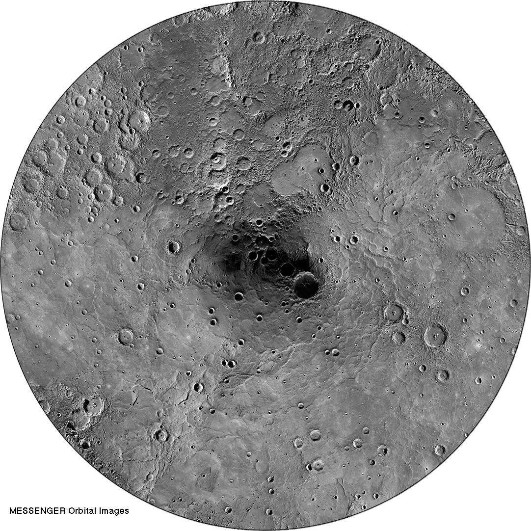
2013-04-08 |
Mercury
|
MESSENGER
|
MDIS - Wide Angle
|
1082x1082x1 |
|
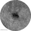
-
PIA16950:
-
Orbital Mosaic of Mercury's North Pole
Full Resolution:
TIFF
(1.172 MB)
JPEG
(272.8 kB)
|
|
|
2013-04-08 |
Mars
|
2001 Mars Odyssey
|
THEMIS
|
1373x3064x1 |

|
-
PIA16242:
-
Images of Gale #4
Full Resolution:
TIFF
(4.212 MB)
JPEG
(317.6 kB)
|
|
|
2013-04-08 |
Mars
|
Mars Science Laboratory (MSL)
|
DAN
|
1312x902x3 |
|
-
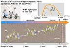
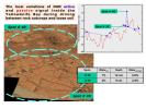
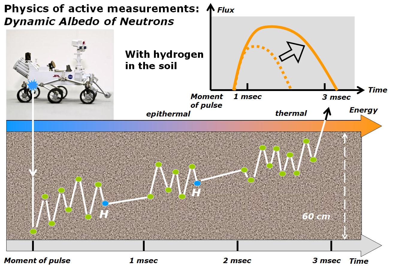
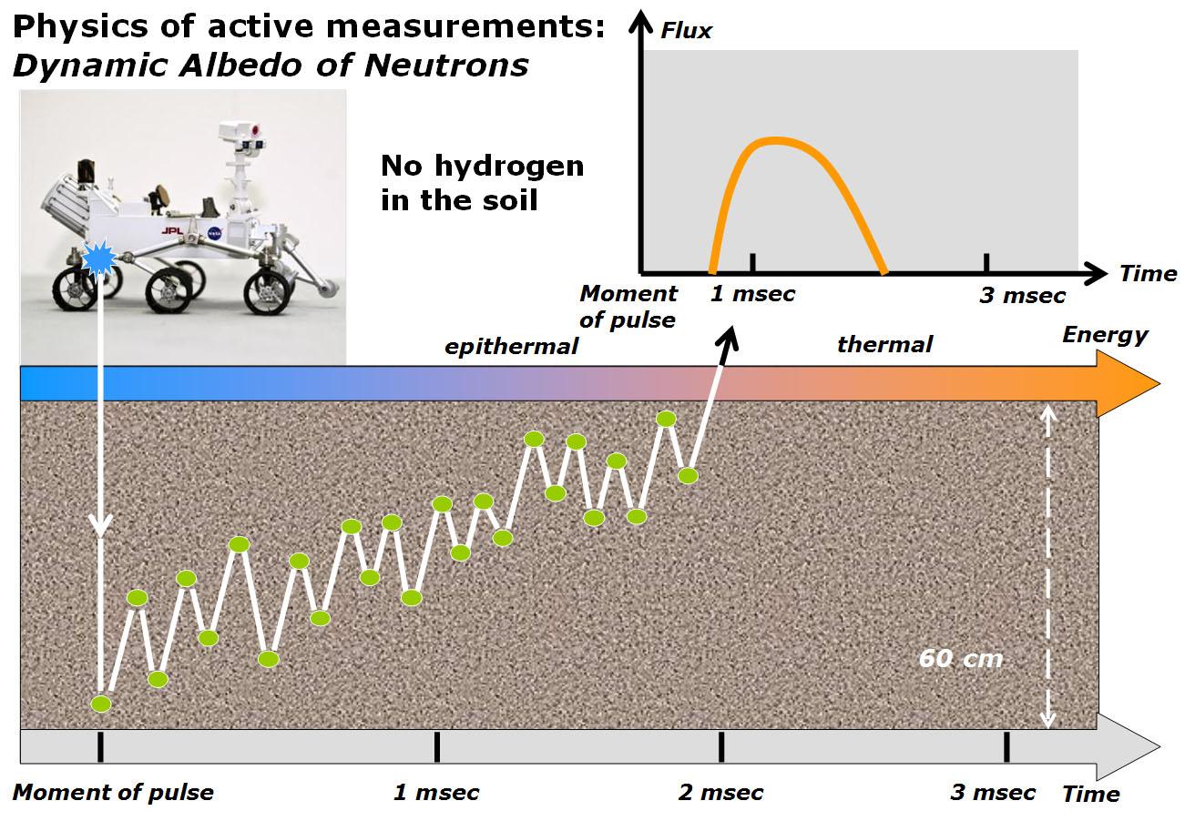
PIA16917:
-
Physics of How DAN on Curiosity Checks for Water, Part 2
Full Resolution:
TIFF
(3.552 MB)
JPEG
(200.8 kB)
|
|
|
2013-04-08 |
Mars
|
Mars Science Laboratory (MSL)
|
DAN
|
1312x902x3 |
|
-
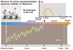
PIA16916:
-
Physics of How DAN on Curiosity Checks for Water, Part 1
Full Resolution:
TIFF
(3.552 MB)
JPEG
(195.2 kB)
|
|
|
2013-04-08 |
Mars
|
Mars Science Laboratory (MSL)
|
REMS
|
831x637x3 |
|
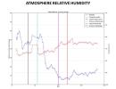
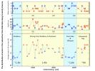
-
PIA16915:
-
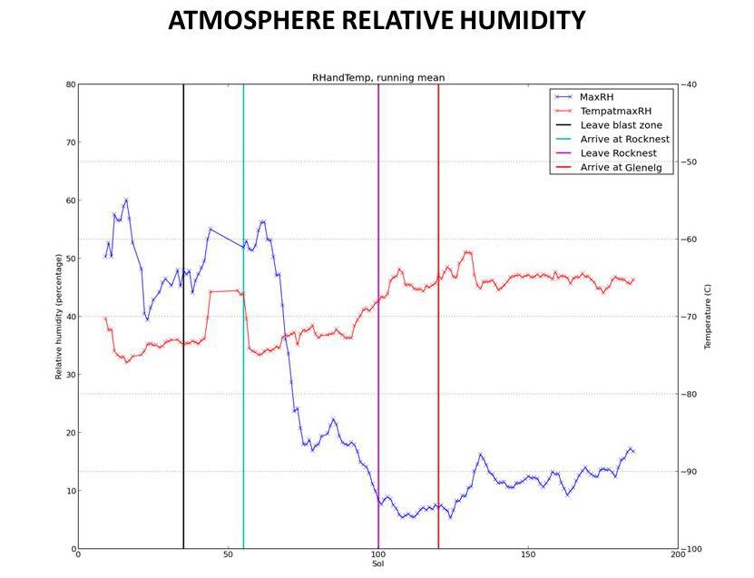
Humidity in Gale Crater: Scant and Variable
Full Resolution:
TIFF
(1.589 MB)
JPEG
(46.41 kB)
|
|
|
2013-04-08 |
Mars
|
Mars Science Laboratory (MSL)
|
REMS
|
890x639x3 |
|
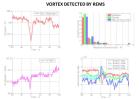
-
PIA16914:
-
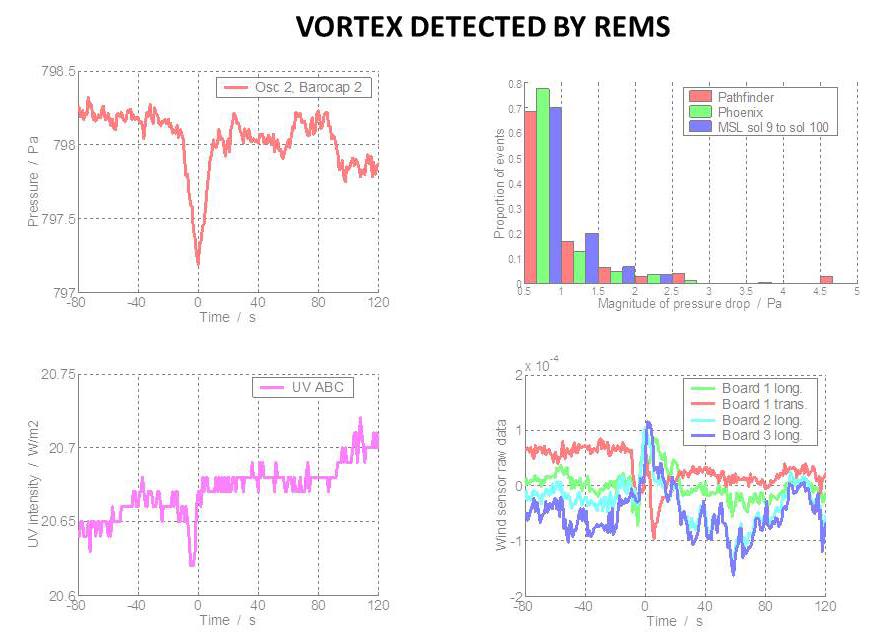
Whirlwind Detection by Curiosity in Gale Crater
Full Resolution:
TIFF
(1.707 MB)
JPEG
(69.34 kB)
|
|
|
2013-04-08 |
Mars
|
Mars Science Laboratory (MSL)
|
REMS
|
700x534x3 |
|
-
PIA16913:
-
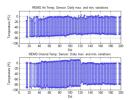
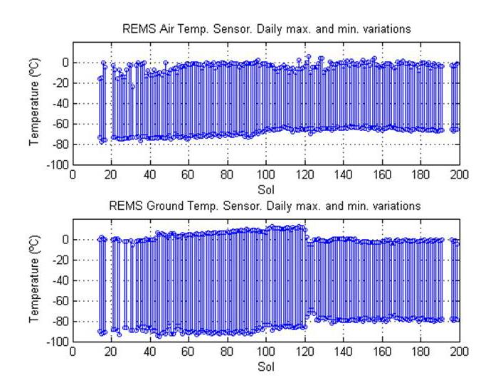
Steady Temperatures at Mars' Gale Crater
Full Resolution:
TIFF
(1.122 MB)
JPEG
(75.76 kB)
|
|
|
2013-04-08 |
Mars
|
Mars Science Laboratory (MSL)
|
REMS
|
664x531x3 |
|
-
PIA16912:
-
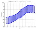
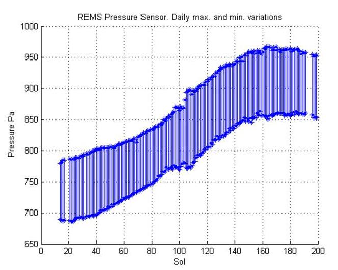
Seasonal Pressure Curve Peaks at Gale Crater
Full Resolution:
TIFF
(1.058 MB)
JPEG
(58.18 kB)
|
|
|
2013-04-08 |
Mars
|
Mars Science Laboratory (MSL)
|
ChemCam
|
960x720x3 |
|
-
PIA16911:
-
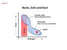
Curiosity's ChemCam Analyzes Rocks, Soils and Dust
Full Resolution:
TIFF
(2.075 MB)
JPEG
(39.68 kB)
|
|
|
2013-04-08 |
Mars
|
Mars Science Laboratory (MSL)
|
ChemCam
|
960x720x3 |
|
-
PIA16910:
-
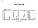
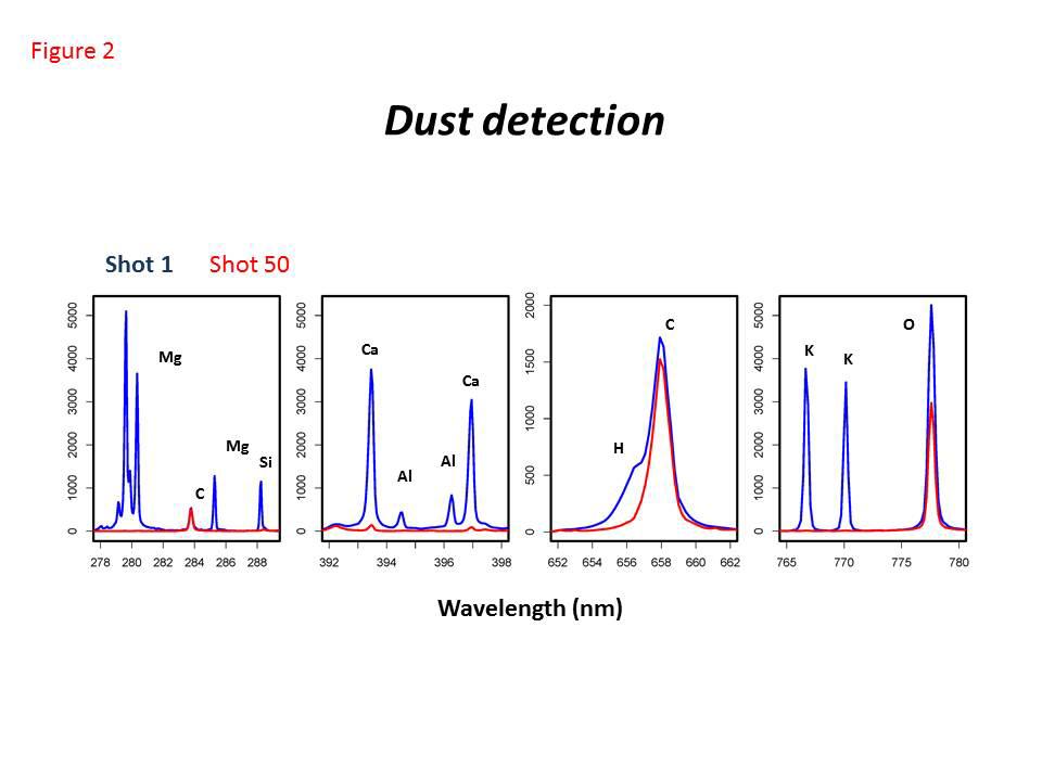
Dust Detection by Curiosity's ChemCam
Full Resolution:
TIFF
(2.075 MB)
JPEG
(48.57 kB)
|
|
|
2013-04-08 |
Mars
|
Mars Science Laboratory (MSL)
|
ChemCam
|
960x720x3 |
|
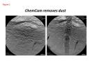
-
PIA16819:
-
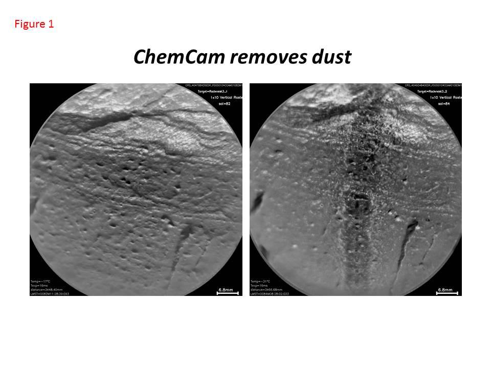
Curiosity's ChemCam Removes Dust
Full Resolution:
TIFF
(2.075 MB)
JPEG
(71.03 kB)
|
|
|
2013-04-08 |
Mars
|
Mars Science Laboratory (MSL)
|
SAM
|
960x720x3 |
|
-
PIA16818:
-
Argon Isotopes Provide Robust Signature of Atmospheric Loss
Full Resolution:
TIFF
(2.075 MB)
JPEG
(65.18 kB)
|
|
|
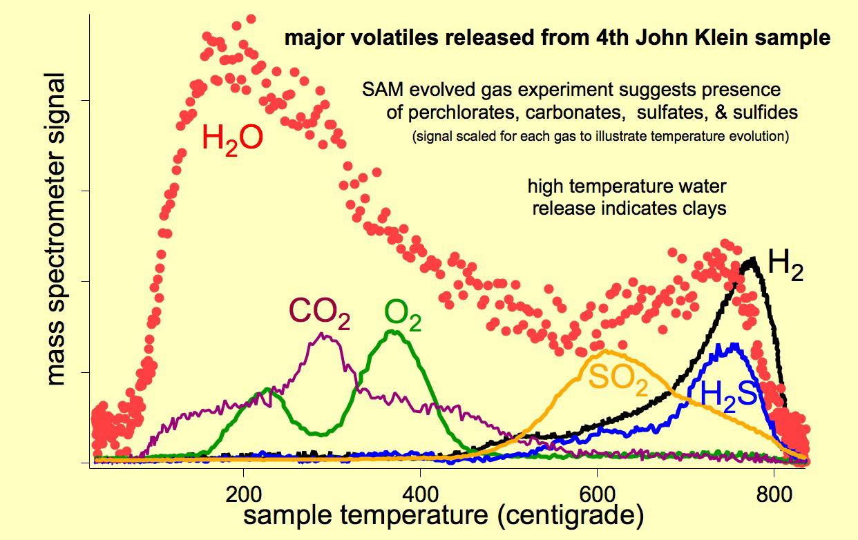
2013-04-08 |
Mars
|
Mars Science Laboratory (MSL)
|
SAM
|
1242x782x3 |
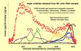
|
-
PIA16817:
-
Major Volatiles Released from the Fourth 'John Klein' Portion
Full Resolution:
TIFF
(2.915 MB)
JPEG
(134.4 kB)
|
|
|
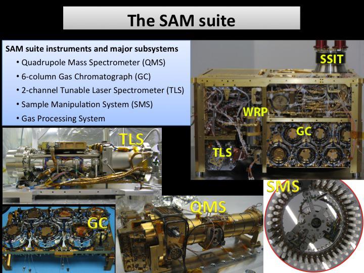
2013-04-08 |
Mars
|
Mars Science Laboratory (MSL)
|
SAM
|
720x540x3 |
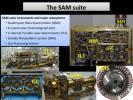
|
-
PIA16816:
-
The SAM Suite
Full Resolution:
TIFF
(1.167 MB)
JPEG
(87.23 kB)
|
|
|
2013-04-08 |
Mars
|
Mars Science Laboratory (MSL)
|
Mastcam
|
1420x1159x3 |
|
-
PIA16815:
-
Dust from Mars Drilling: Tailings and Discard Piles
Full Resolution:
TIFF
(4.939 MB)
JPEG
(335.9 kB)
|
|
|
2013-04-08 |
Titan
|
Cassini-Huygens
|
ISS - Narrow Angle
|
1018x1018x1 |

|
-
PIA14655:
-
Spying on Senkyo
Full Resolution:
TIFF
(1.038 MB)
JPEG
(32.53 kB)
|
|
|
2013-04-05 |
Earth
|
Terra
|
ASTER
|
1706x1796x3 |

|
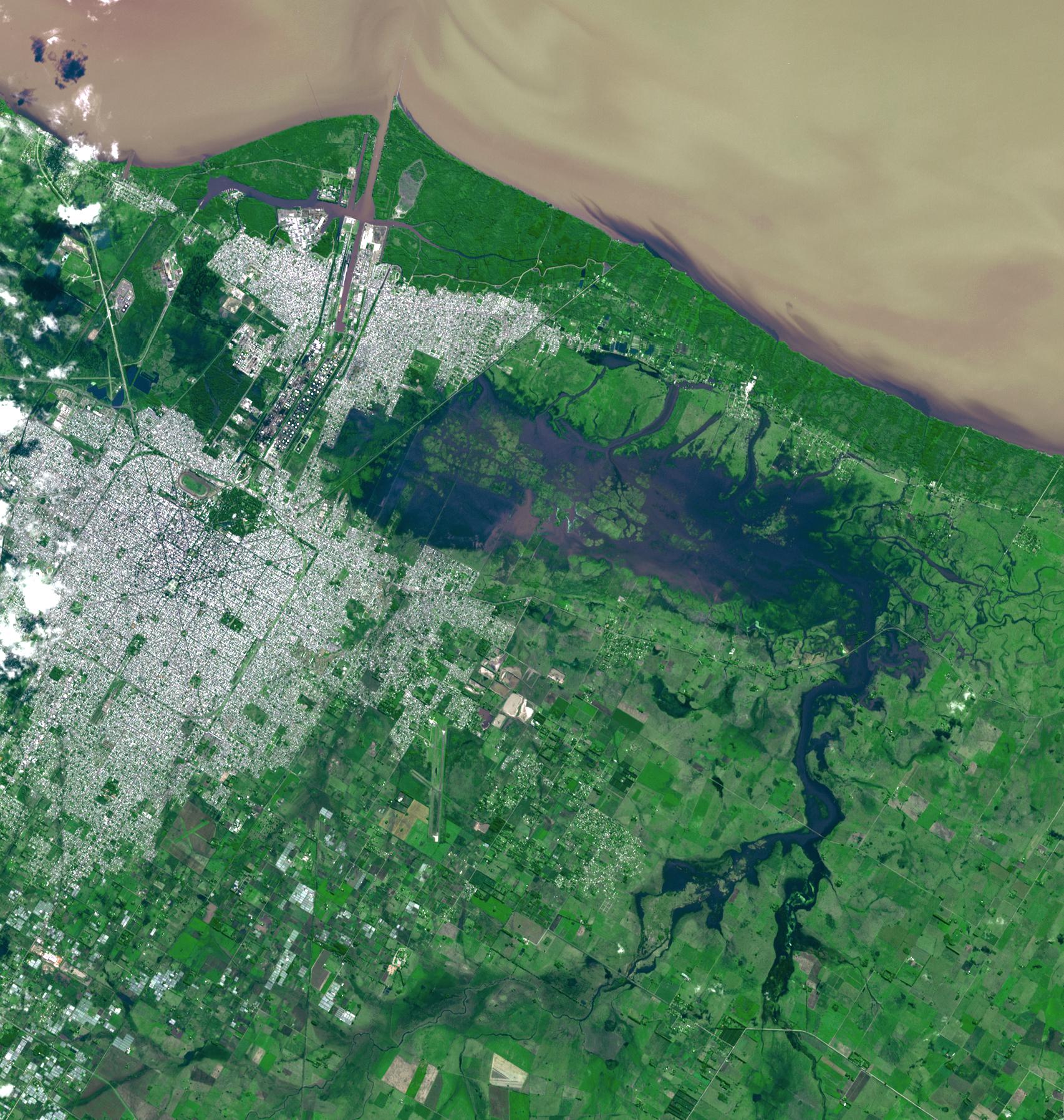
-
PIA16945:
-
NASA Spacecraft Eyes Severe Flooding in Argentina
Full Resolution:
TIFF
(9.196 MB)
JPEG
(583.5 kB)
|
|
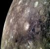
|
2013-04-05 |
Mercury
|
MESSENGER
|
MDIS - Narrow Angle
|
1442x1184x1 |
|
-
PIA16949:
-
An Extra Kidney?
Full Resolution:
TIFF
(1.709 MB)
JPEG
(177.2 kB)
|
|
|
2013-04-05 |
Mars
|
2001 Mars Odyssey
|
THEMIS
|
1376x3059x1 |
|
-
PIA16241:
-
Images of Gale #3
Full Resolution:
TIFF
(4.214 MB)
JPEG
(336.9 kB)
|
|
|
2013-04-04 |
Earth
|
Terra
|
ASTER
|
1015x667x3 |
|
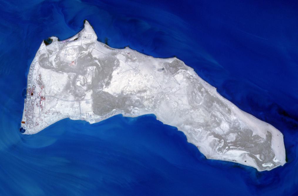
-
PIA16944:
-
Failaka Island, Kuwait
Full Resolution:
TIFF
(2.032 MB)
JPEG
(58.53 kB)
|
|
|
2013-04-04 |
|
Kepler
|
|
3000x2400x3 |
|
-
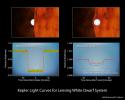
PIA16886:
-
White Dwarfs: Small and Strong
Full Resolution:
TIFF
(21.61 MB)
JPEG
(404.9 kB)
|
|
|
2013-04-04 |
|
Kepler
|
|
5120x2880x3 |
|
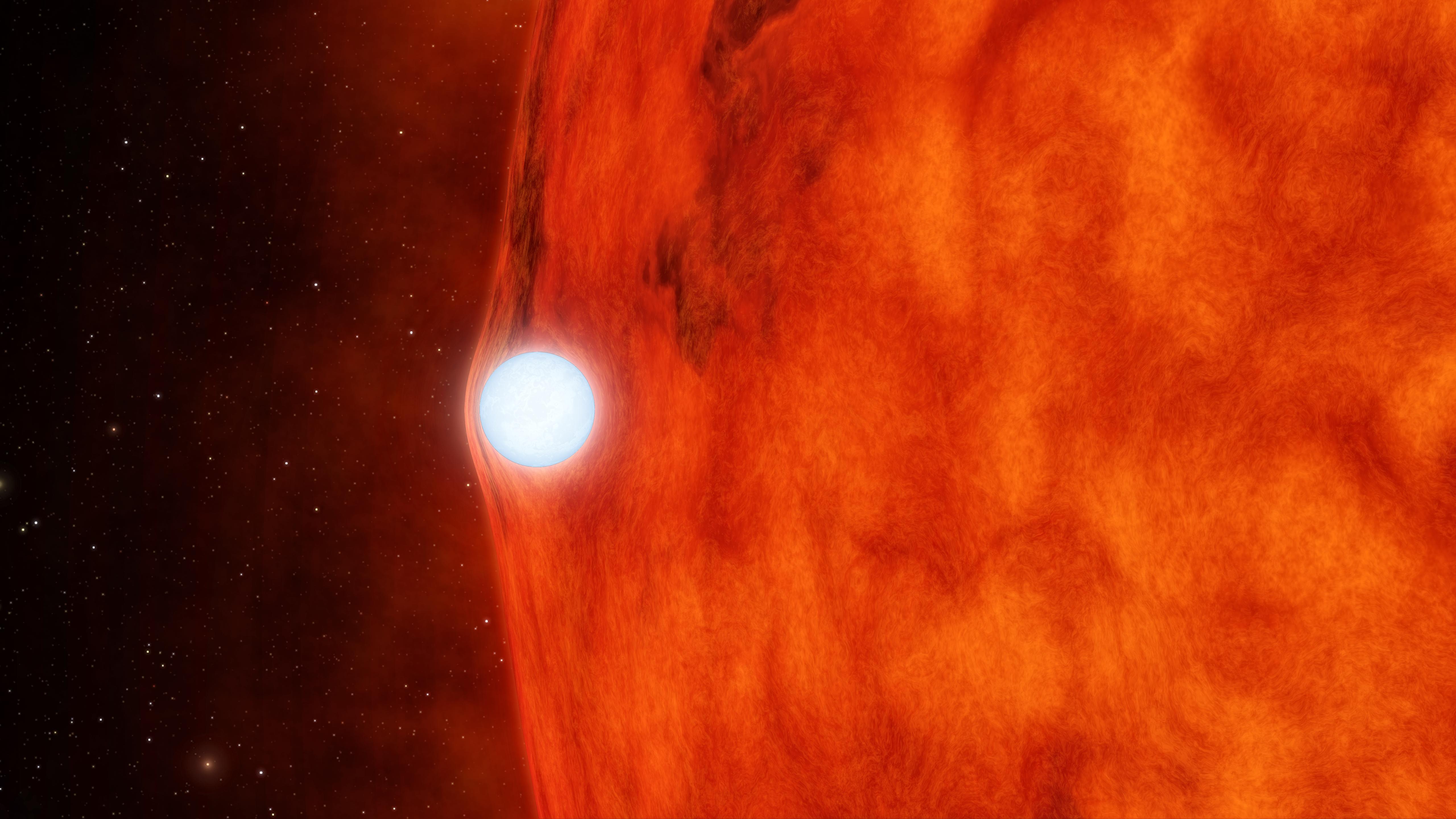
-
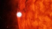
PIA16885:
-
Dead Star Warps Light of Red Star (Artist's Animation)

Full Resolution:
TIFF
(44.26 MB)
JPEG
(907.2 kB)
|
|
|
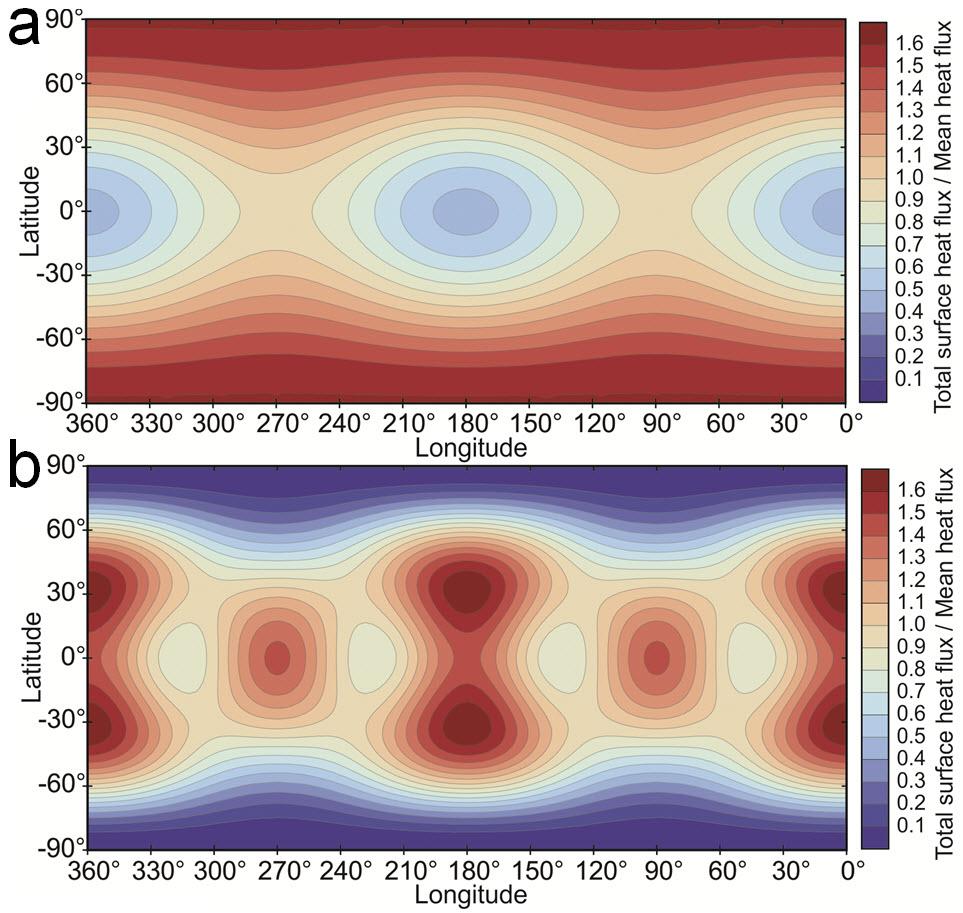
2013-04-04 |
Io
|
|
|
963x913x3 |
|
-
PIA16941:
-
Io Predicted Heat Flow Map
Full Resolution:
TIFF
(2.639 MB)
JPEG
(126.6 kB)
|
|
|
2013-04-04 |
Mercury
|
MESSENGER
|
MDIS - Narrow Angle
|
1924x1763x1 |
|
-
PIA16948:
-
Crater Down
Full Resolution:
TIFF
(3.396 MB)
JPEG
(211 kB)
|
|
|
2013-04-04 |
Mars
|
2001 Mars Odyssey
|
THEMIS
|
1364x3064x1 |
|
-
PIA16240:
-
Images of Gale #2
Full Resolution:
TIFF
(4.184 MB)
JPEG
(351 kB)
|
|
|
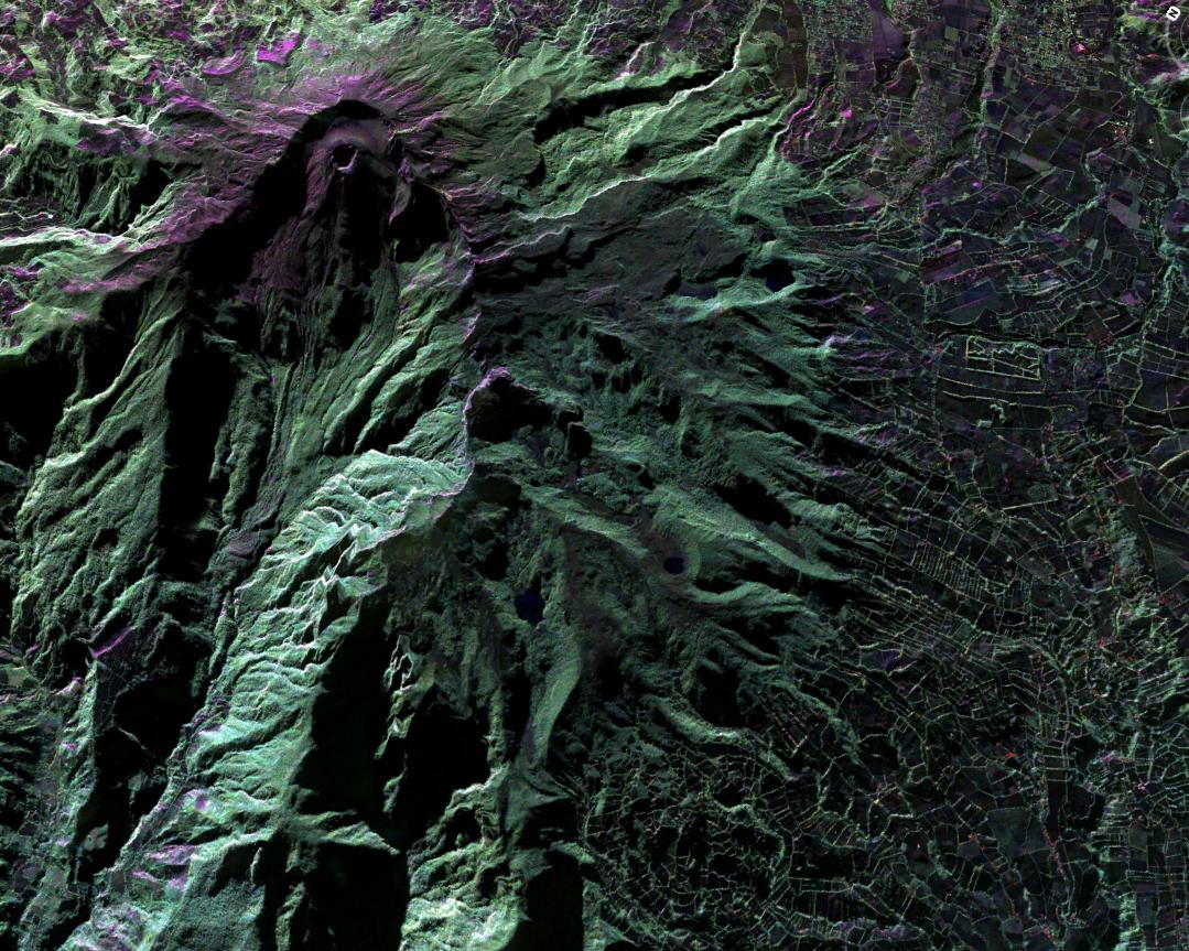
2013-04-03 |
Earth
|
UAVSAR
|
L-Band UAVSAR
|
1079x863x3 |
|
-
PIA16943:
-
UAVSAR Acquires False-Color Image of Galeras Volcano, Colombia
Full Resolution:
TIFF
(2.795 MB)
JPEG
(230.9 kB)
|
|
|
2013-04-03 |
Earth
|
UAVSAR
|
L-Band UAVSAR
|
2806x1314x3 |
|
-
PIA16942:
-
NASA Sends Unmanned Aircraft To Study Volcanoes and Wetlands
Full Resolution:
TIFF
(11.07 MB)
JPEG
(1.742 MB)
|
|
|
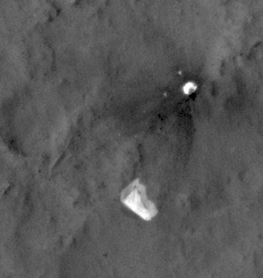
2013-04-03 |
Mars
|
Mars Reconnaissance Orbiter (MRO)
Mars Science Laboratory (MSL)
|
HiRISE
|
369x390x1 |
|
-
PIA16813:
-
MSL's Parachute Flapping in the Wind
Full Resolution:
TIFF
(144.3 kB)
JPEG
(15.5 kB)
|
|
|
2013-04-03 |
|
Chandra X-ray Observatory
Hubble Space Telescope
Spitzer Space Telescope
|
Chandra X-ray Telescope
IRAC
Visible-Light
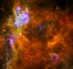
|
3600x3600x3 |
|
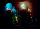
-
PIA16884:
-
Taken Under the 'Wing' of the Small Magellanic Cloud
Full Resolution:
TIFF
(38.89 MB)
JPEG
(1.685 MB)
|
|
|
2013-04-03 |
|
|
|
3648x2736x3 |
|
-
PIA16843:
-
Simulating Titan-Like Smog
Full Resolution:
TIFF
(29.95 MB)
JPEG
(630 kB)
|
|
|
2013-04-03 |
Mercury
|
MESSENGER
|
MDIS - Narrow Angle
|
1358x1262x1 |

|
-
PIA16947:
-
Feeling a Bit Rough?
Full Resolution:
TIFF
(1.716 MB)
JPEG
(179.1 kB)
|
|
|
2013-04-03 |
Mars
|
2001 Mars Odyssey
|
THEMIS
|
1337x2774x1 |
|
-
PIA16289:
-
Curiosity Landing Site
Full Resolution:
TIFF
(3.713 MB)
JPEG
(364.8 kB)
|
|
|
2013-04-02 |
Mercury
|
MESSENGER
|
MDIS - Narrow Angle
|
1284x1272x1 |
|
-
PIA16940:
-
An Unnamed Wonder
Full Resolution:
TIFF
(1.635 MB)
JPEG
(140.2 kB)
|
|
|
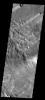
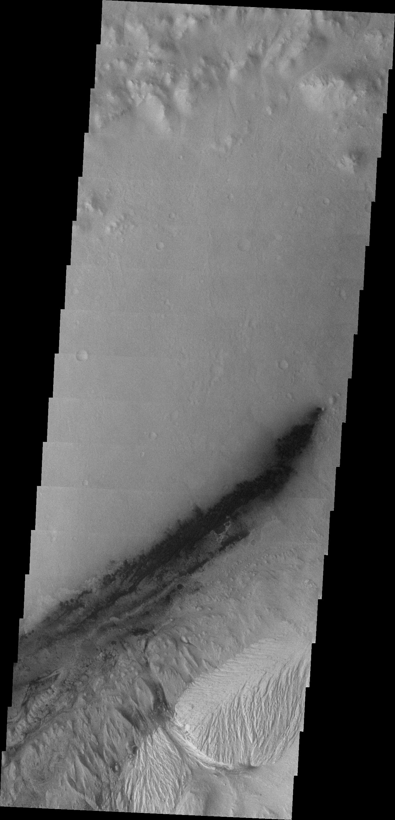
2013-04-02 |
Mars
|
2001 Mars Odyssey
|
THEMIS
|
1330x2818x1 |
|
-
PIA16288:
-
Gullies
Full Resolution:
TIFF
(3.752 MB)
JPEG
(267 kB)
|
|
|
2013-04-01 |
Mars
|
2001 Mars Odyssey
|
THEMIS
|
1310x2814x1 |
|
-
PIA16287:
-
Rabe Crater Dunes
Full Resolution:
TIFF
(3.69 MB)
JPEG
(168.1 kB)
|
|
|
2013-04-01 |
Prometheus
|
Cassini-Huygens
|
ISS - Narrow Angle
|
1016x1016x1 |
|
-
PIA14657:
-
A Shepherd's Watch
Full Resolution:
TIFF
(1.033 MB)
JPEG
(44.87 kB)
|
|
|
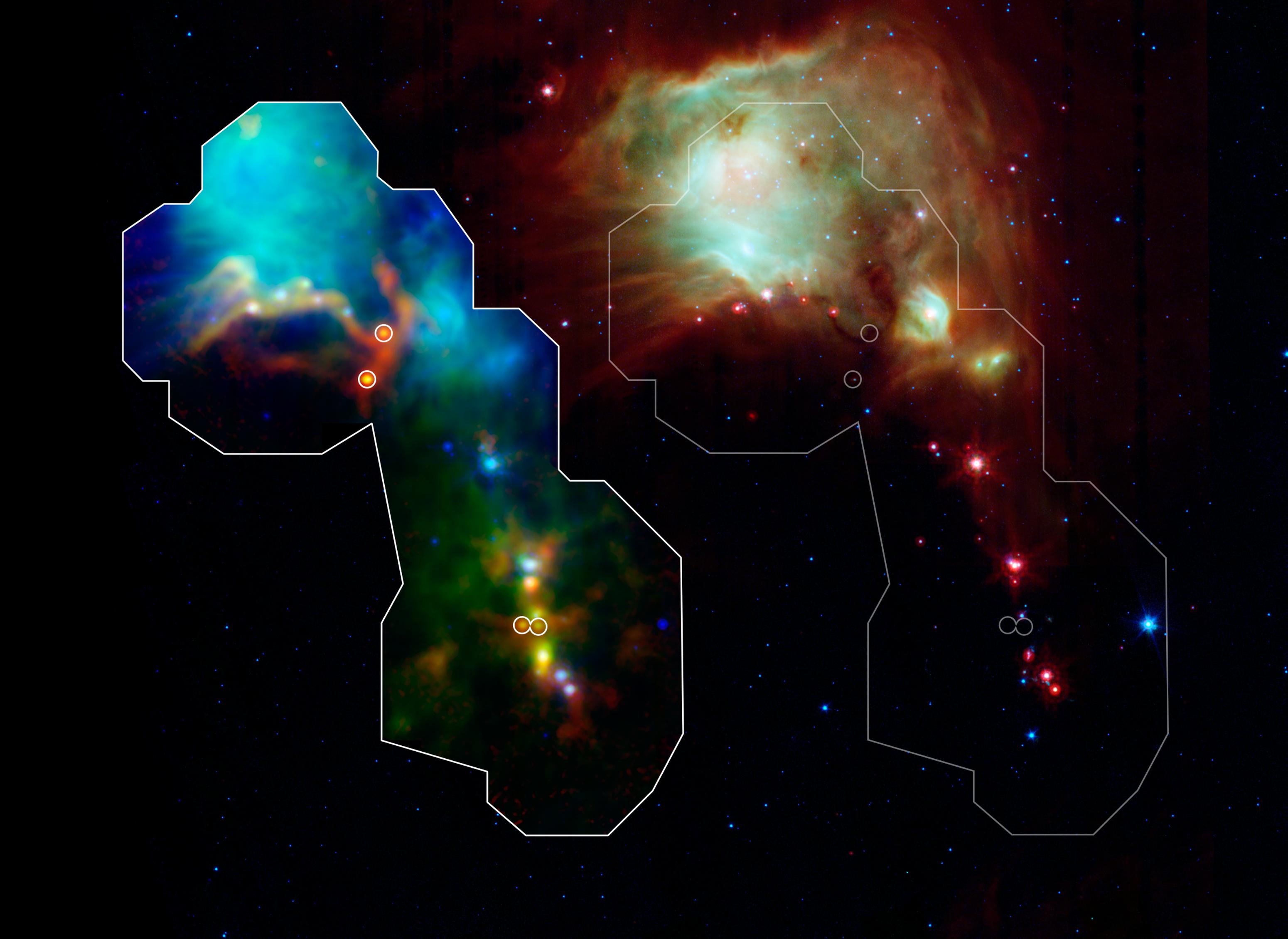
2013-03-29 |
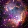
|
Herschel Space Observatory
|
PACS
SPIRE
|
1500x1434x3 |
|
-
PIA16883:
-
Churning Out Stars
Full Resolution:
TIFF
(6.456 MB)
JPEG
(182.4 kB)
|
|
|
2013-03-29 |
Mercury
|
MESSENGER
|
MDIS - Wide Angle
|
1476x1534x3 |
|
-
PIA16908:
-
Mercury, Mercury!
Full Resolution:
TIFF
(6.795 MB)
JPEG
(257.9 kB)
|
|
|
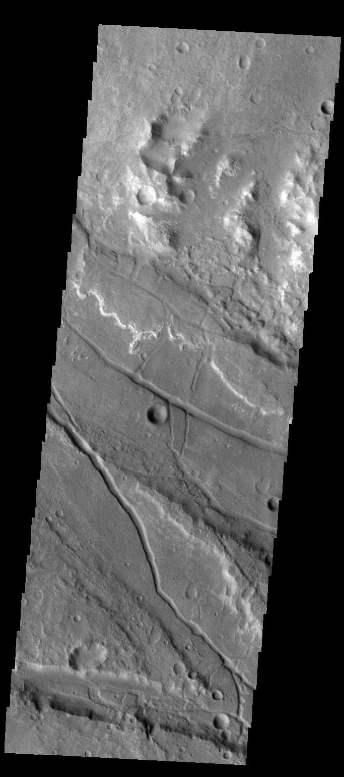
2013-03-29 |
Mars
|
2001 Mars Odyssey
|
THEMIS
|
1315x2786x1 |
|
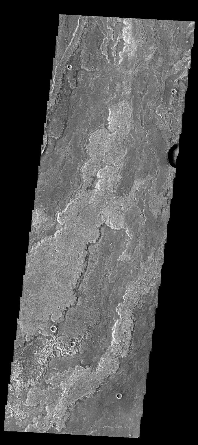
-
PIA16286:
-
Arda Valles
Full Resolution:
TIFF
(3.668 MB)
JPEG
(350.1 kB)
|
|
|
2013-03-28 |
Mercury
|
MESSENGER
|
MDIS - Wide Angle
|
1003x987x3 |
|
-
PIA16907:
-
A Colorful Group
Full Resolution:
TIFF
(2.971 MB)
JPEG
(198.7 kB)
|
|
|
2013-03-28 |
Mars
|
2001 Mars Odyssey
|
THEMIS
|
693x1539x1 |
|
-
PIA16285:
-
Windstreaks
Full Resolution:
TIFF
(1.068 MB)
JPEG
(122.1 kB)
|
|
|
2013-03-27 |
Mercury
|
MESSENGER
|
MDIS - Wide Angle
|
923x866x3 |
|
-
PIA16906:
-
Botticelli in Low-Phase Color
Full Resolution:
TIFF
(2.399 MB)
JPEG
(96.72 kB)
|
|
|
2013-03-27 |
Mars
|
2001 Mars Odyssey
|
THEMIS
|
685x1539x1 |
|
-
PIA16284:
-
Daedalia Planum
Full Resolution:
TIFF
(1.056 MB)
JPEG
(181.8 kB)
|
|
|
2013-03-26 |
Mercury
|
MESSENGER
|
MDIS - Wide Angle
|
1024x1020x1 |

|
-
PIA16904:
-
The Amazing Rays
Full Resolution:
TIFF
(1.046 MB)
JPEG
(161.8 kB)
|
|
|
2013-03-26 |
Mars
|
2001 Mars Odyssey
|
THEMIS
|
1332x2787x1 |
|
-
PIA16283:
-
Arda Valles
Full Resolution:
TIFF
(3.716 MB)
JPEG
(413.2 kB)
|
|
|
2013-03-25 |
Mars
|
Mars Science Laboratory (MSL)
|
Navcam (MSL)
|
1024x1024x1 |
|
-
PIA16812:
-
View From Camera Not Used During Curiosity's First Six Months on Mars
Full Resolution:
TIFF
(1.05 MB)
JPEG
(241.9 kB)
|
|
|
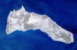
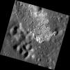
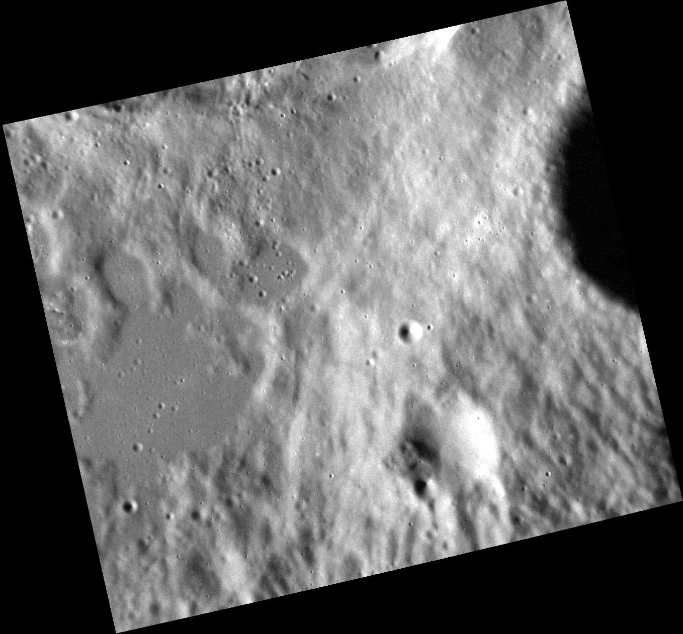
2013-03-25 |
Vesta
|
Dawn
Lunar Reconnaissance Orbiter (LRO)
|
|
1824x970x3 |
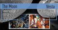
|
-
PIA16841:
-
A Shared Bombardment History
Full Resolution:
TIFF
(5.31 MB)
JPEG
(301.9 kB)
|
|
|
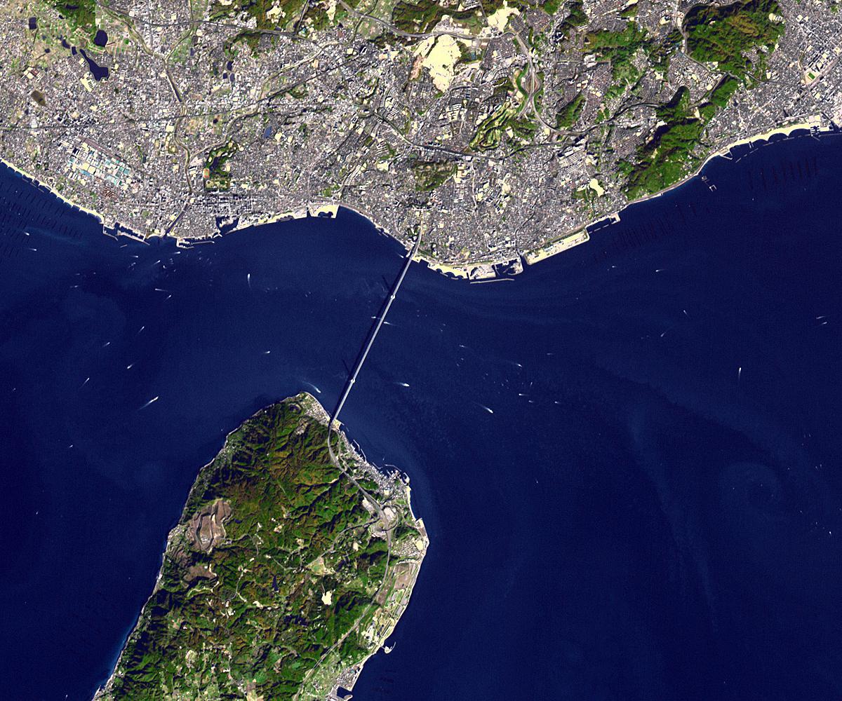
2013-03-25 |
Earth
|
Terra
|
ASTER
|
1200x1000x3 |
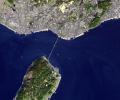
|
-
PIA16905:
-
Akashi Kaikyo Bridge, Japan
Full Resolution:
TIFF
(3.602 MB)
JPEG
(266.1 kB)
|
|
|
2013-03-25 |
Mercury
|
MESSENGER
|
MDIS - Narrow Angle
|
508x512x1 |
|
-
PIA16903:
-
Pahinui Crater
Full Resolution:
TIFF
(260.6 kB)
JPEG
(38.44 kB)
|
|
|
2013-03-25 |
Mars
|
2001 Mars Odyssey
|
THEMIS
|
696x1540x1 |

|
-
PIA16282:
-
Channel
Full Resolution:
TIFF
(1.073 MB)
JPEG
(106.9 kB)
|
|
|
2013-03-25 |
Rhea
|
Cassini-Huygens
|
ISS - Narrow Angle
|
1016x1016x1 |
|
-
PIA14654:
-
Rhea's Record
Full Resolution:
TIFF
(1.033 MB)
JPEG
(189.3 kB)
|
|
|
2013-03-22 |
Mercury
|
MESSENGER
|
MDIS - Narrow Angle
|
1024x1024x1 |
|
-
PIA16902:
-
Aksakov Askew
Full Resolution:
TIFF
(1.05 MB)
JPEG
(112.6 kB)
|
|
|
2013-03-22 |
Mars
|
2001 Mars Odyssey
|
THEMIS
|
691x1538x1 |
|
-
PIA16281:
-
Ganges Chasma
Full Resolution:
TIFF
(1.064 MB)
JPEG
(56.36 kB)
|
|
|
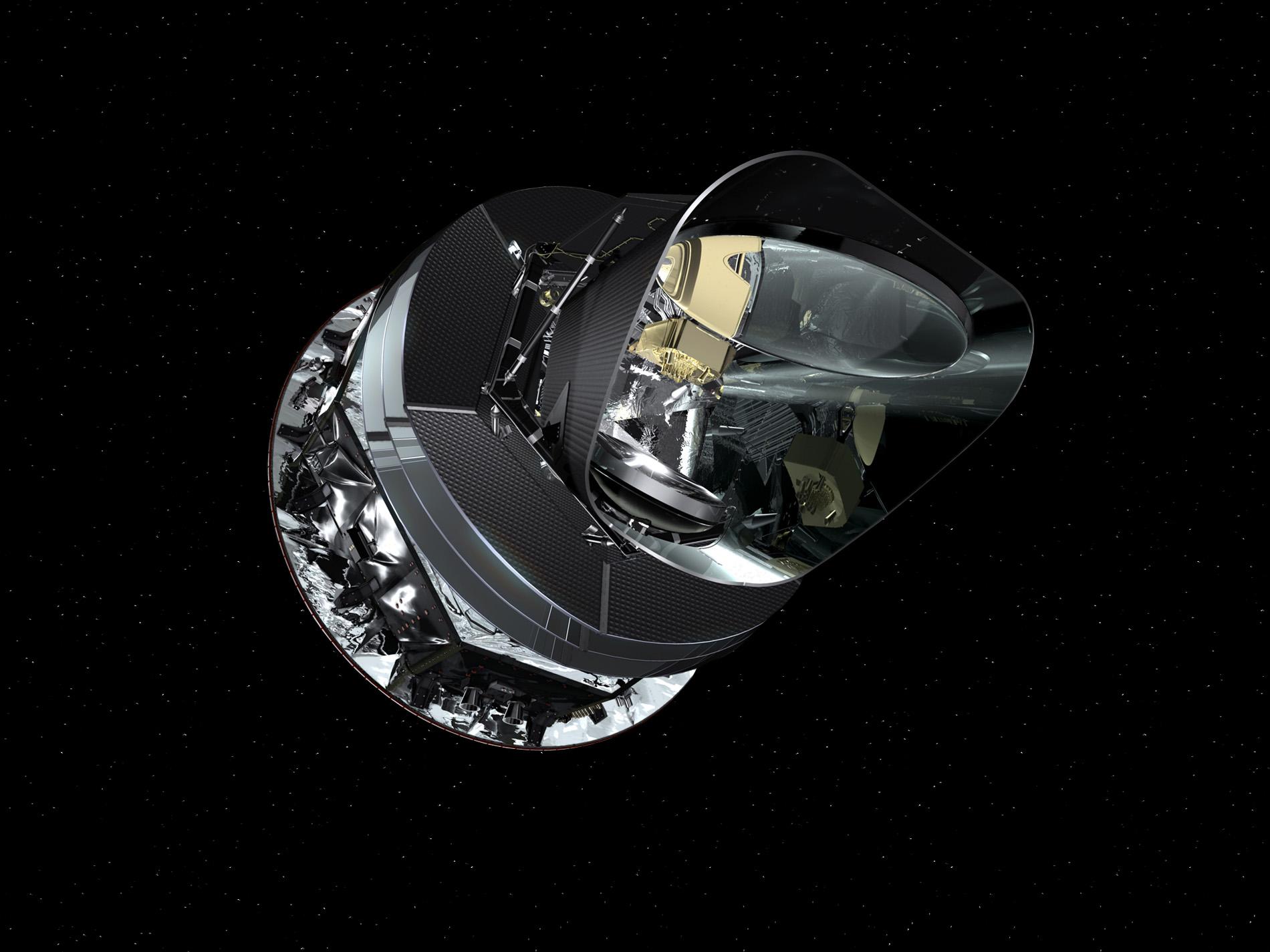
2013-03-21 |
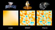
|
Planck
|
|
1276x719x3 |

|
-
PIA16882:
-
A Journey of Light Through Space and Time
Full Resolution:
TIFF
(2.754 MB)
JPEG
(81.33 kB)
|
|
|
2013-03-21 |
Mercury
|
MESSENGER
|
MDIS - Narrow Angle
|
1024x1024x1 |

|
-
PIA16901:
-
Silky Smooth
Full Resolution:
TIFF
(1.05 MB)
JPEG
(83.19 kB)
|
|
|
2013-03-21 |
Mars
|
2001 Mars Odyssey
|
THEMIS
|
1339x2931x1 |

|
-
PIA16280:
-
Coprates Catena
Full Resolution:
TIFF
(3.929 MB)
JPEG
(245.4 kB)
|
|
|
2013-03-21 |
|
Planck
|
|
1900x1425x3 |
|
-
PIA16881:
-
Sounds of the Ancient Universe
Full Resolution:
TIFF
(8.126 MB)
JPEG
(186.9 kB)
|
|
|
2013-03-21 |
|
Planck
|
|
640x320x3 |
|
-
PIA16880:
-
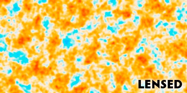
Through the Universe's Looking Glass
Full Resolution:
TIFF
(206.8 kB)
JPEG
(36.61 kB)
|
|
|
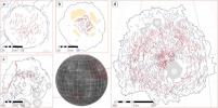
2013-03-21 |
|
Planck
|
|
1651x1275x3 |
|
-
PIA16879:
-
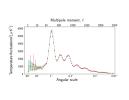
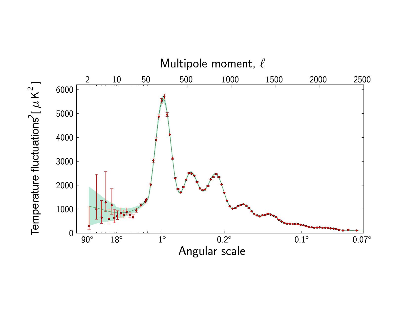
The Universe, Summed Up in a Squiggly Line
Full Resolution:
TIFF
(6.318 MB)
JPEG
(101.2 kB)
|
|
|
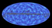
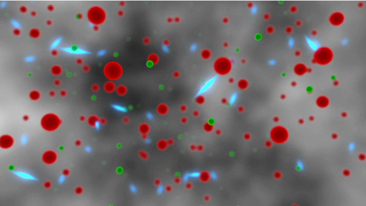
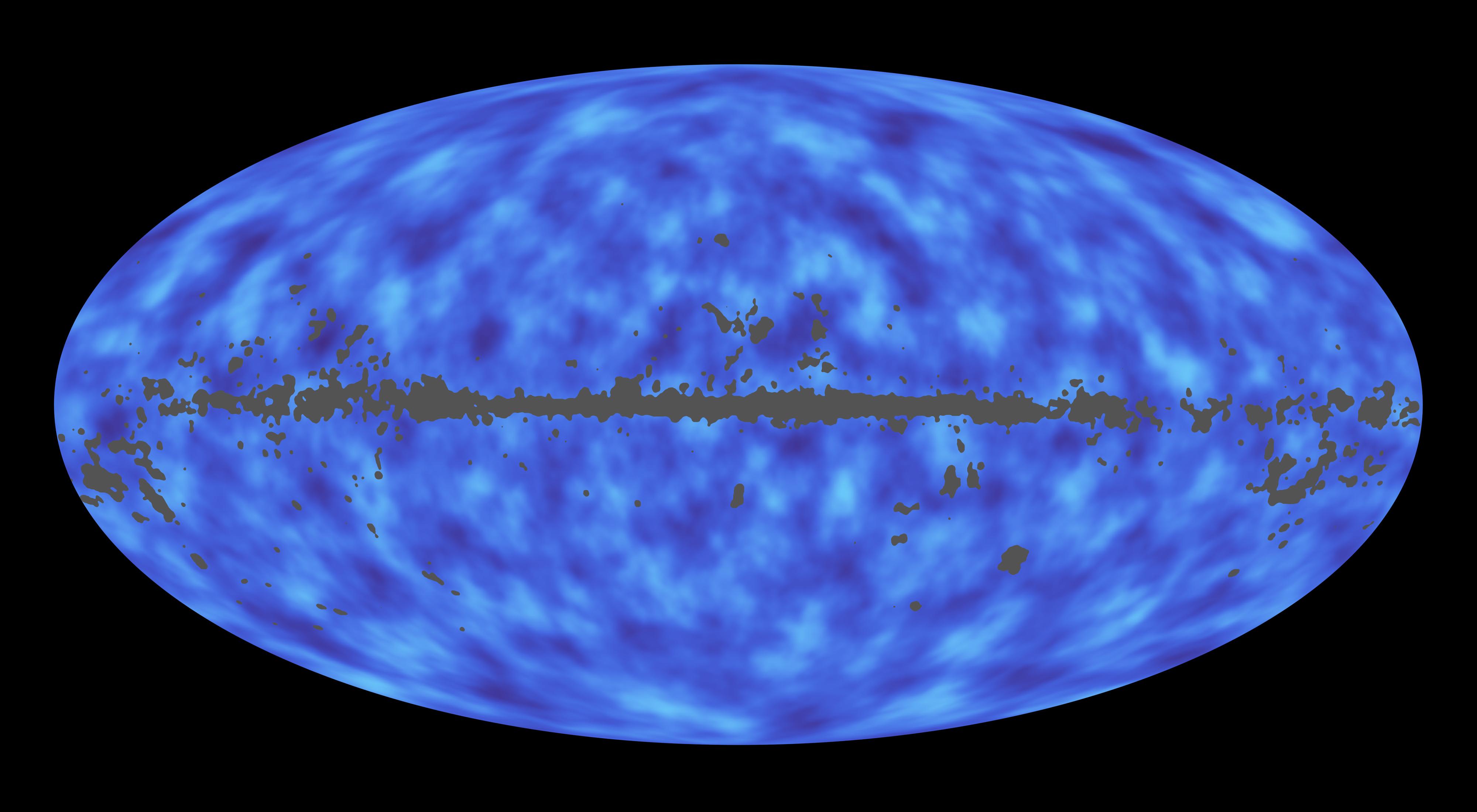
2013-03-21 |
|
Planck
|
|
1191x842x3 |
|
-
PIA16878:
-
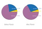
Refining the Ingredients of Our Universe
Full Resolution:
TIFF
(3.01 MB)
JPEG
(47 kB)
|
|
|
2013-03-21 |
|
Planck
|
|
3200x1800x3 |
|
-
PIA16877:
-
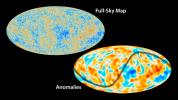
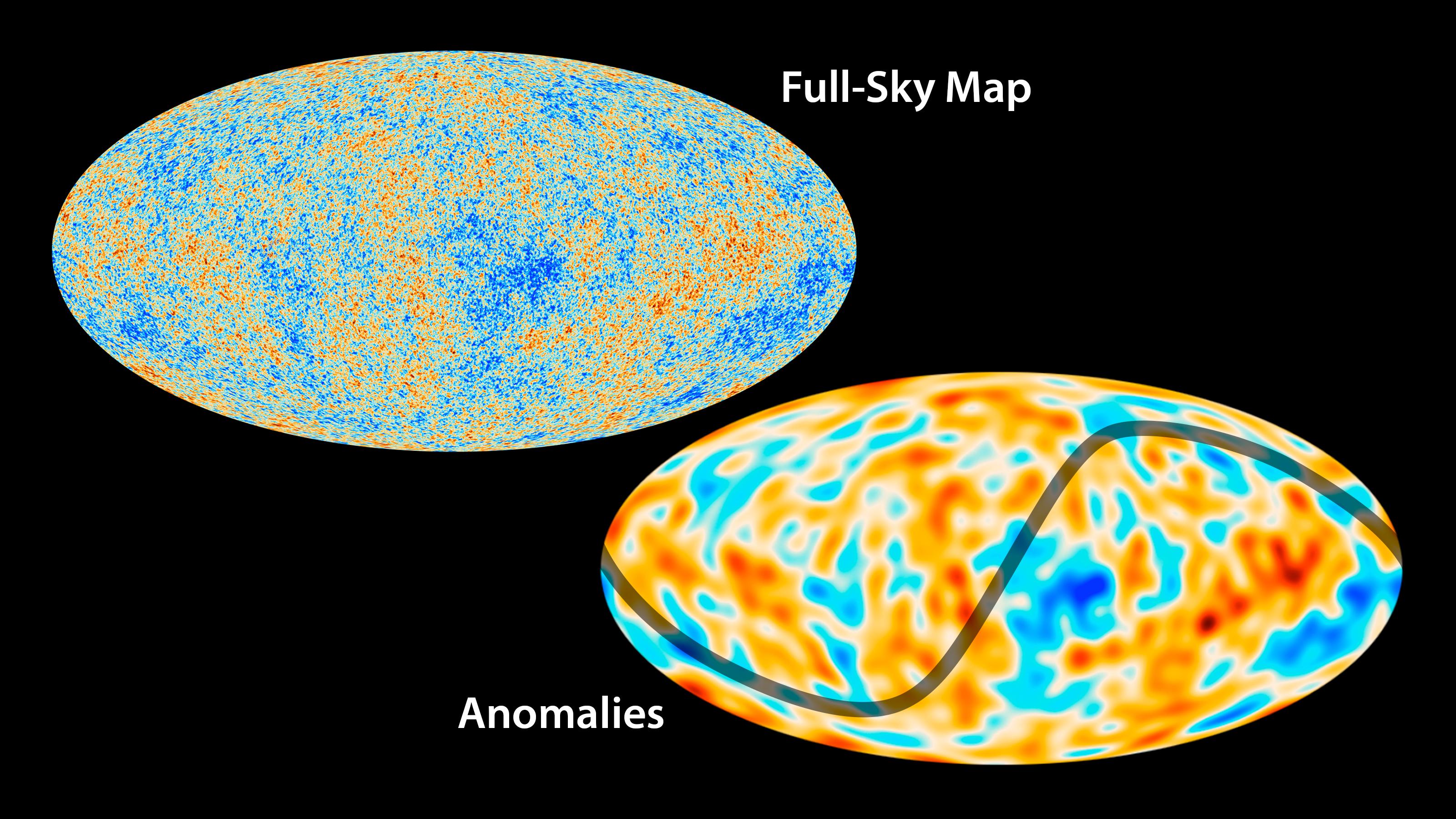
Peculiar Features in Patterns of Ancient Light
Full Resolution:
TIFF
(17.29 MB)
JPEG
(771.9 kB)
|
|
|
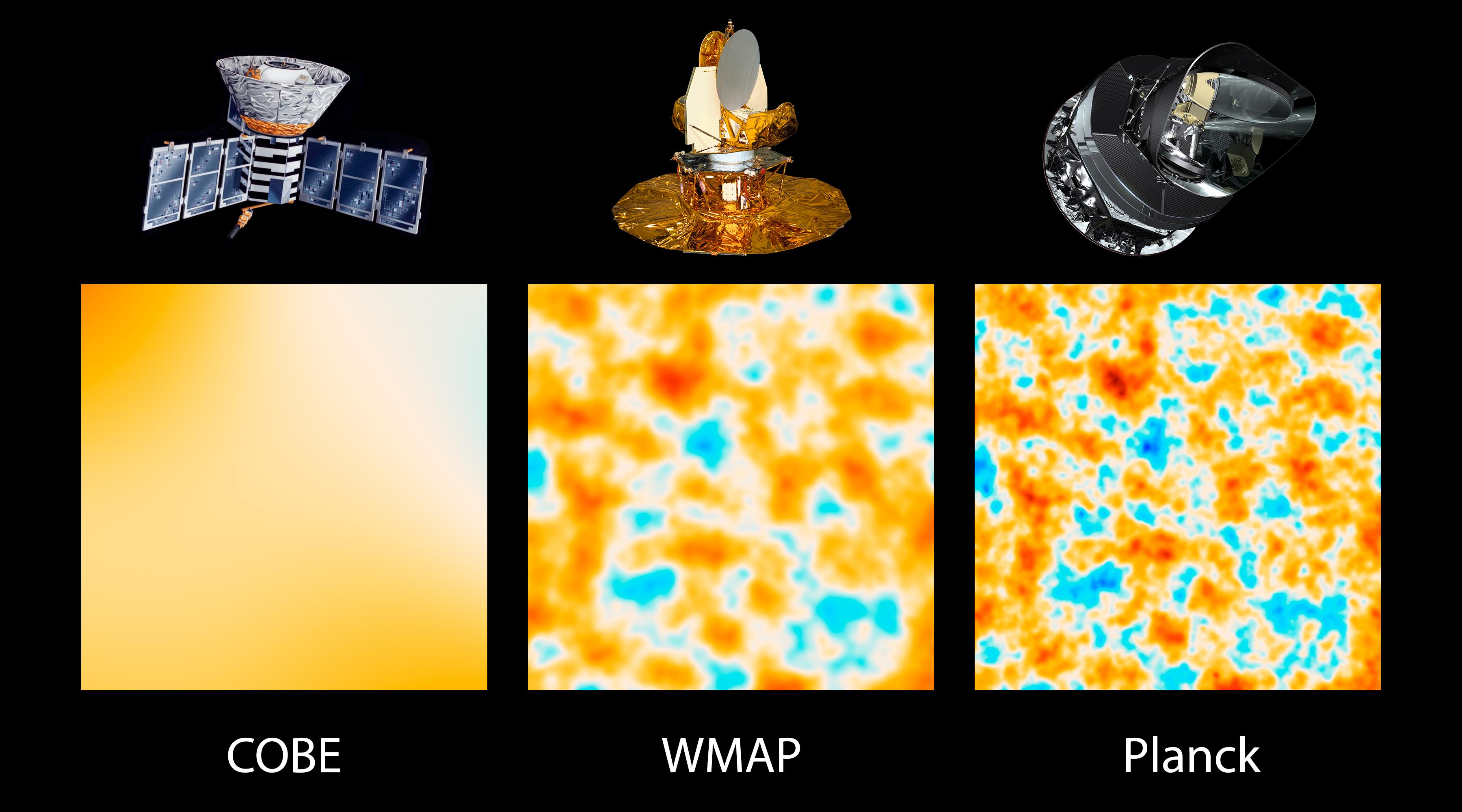
2013-03-21 |
|
Planck
|
|
5305x2342x3 |
|
-
PIA16876:
-
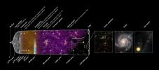
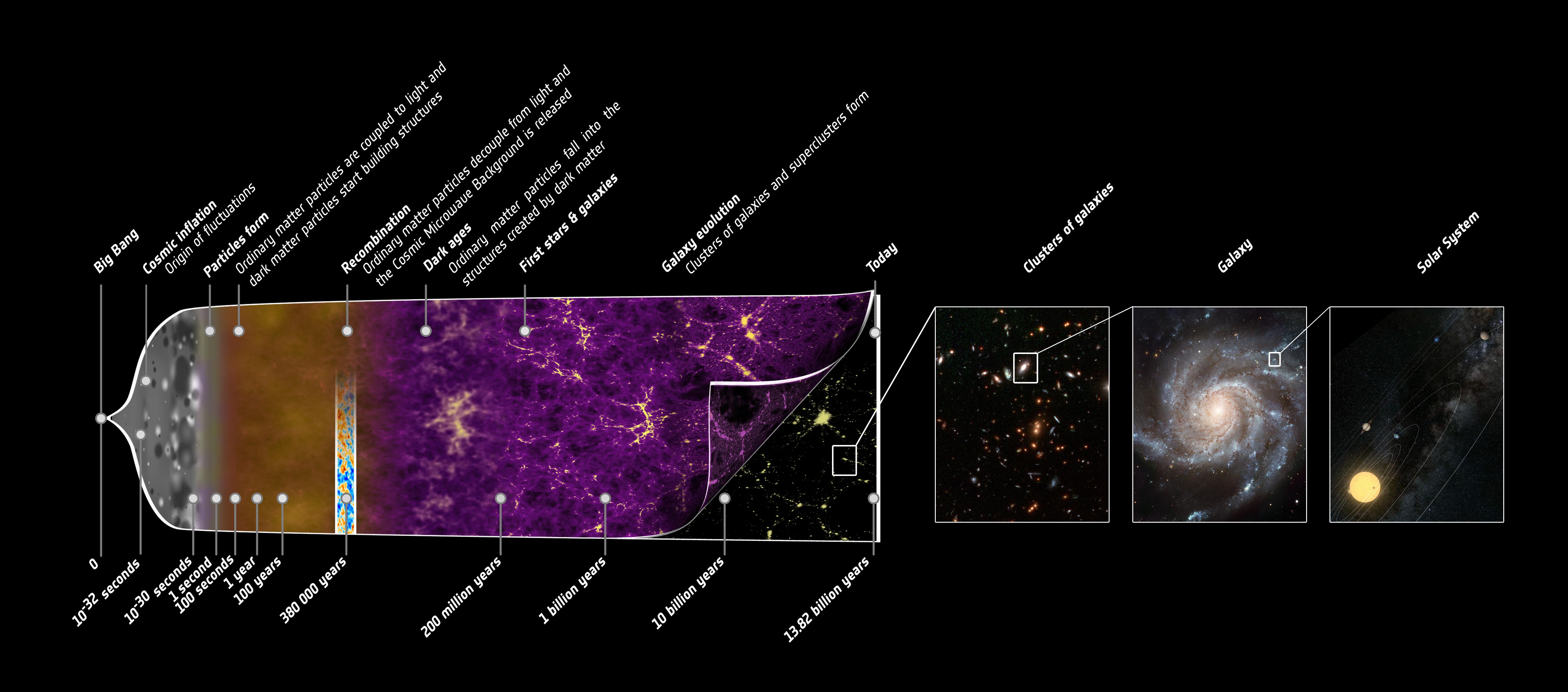
The Story of Our Universe
Full Resolution:
TIFF
(37.29 MB)
JPEG
(784.4 kB)
|
|
|
2013-03-21 |
|
Planck
|
|
4000x2200x3 |
|
-
PIA16875:
-
Map of Matter in the Universe
Full Resolution:
TIFF
(26.41 MB)
JPEG
(330.2 kB)
|
|
|
2013-03-21 |
|
Planck
|
|
3600x2000x3 |
|
-
PIA16874:
-
The Universe Comes into Sharper Focus
Full Resolution:
TIFF
(21.61 MB)
JPEG
(430.9 kB)
|
|
|
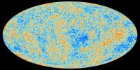
2013-03-21 |
|
Planck
|
|
3600x1800x3 |
|
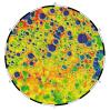
-
PIA16873:
-
Best Map Ever of the Universe
Full Resolution:
TIFF
(19.45 MB)
JPEG
(2.28 MB)
|
|
|
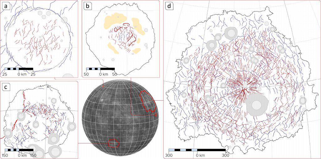
2013-03-20 |
Mercury
|
MESSENGER
|
|
1024x509x3 |
|
-
PIA16900:
-
Tectonic Complexity in Mercury's Impact Features
Full Resolution:
TIFF
(1.564 MB)
JPEG
(136.3 kB)
|
|
|
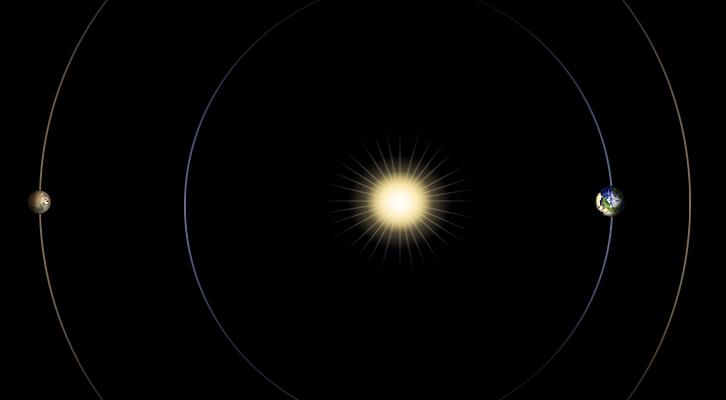
2013-03-20 |
Mars
|
|
|
726x400x3 |
|
-
PIA16811:
-
Geometry of Mars Solar Conjunction
Full Resolution:
TIFF
(871.7 kB)
JPEG
(12.1 kB)
|
|
|
2013-03-20 |
Mars
|
2001 Mars Odyssey
|
THEMIS
|
1358x2836x1 |

|
-
PIA16279:
-
Dunes
Full Resolution:
TIFF
(3.855 MB)
JPEG
(234.4 kB)
|
|
|
2013-03-19 |
Moon
|
GRAIL
|
|
2022x2040x3 |
|
-
PIA16896:
-
Gravity at the Moon's North Pole
Full Resolution:
TIFF
(12.38 MB)
JPEG
(1.121 MB)
|
|
|
2013-03-19 |
|
Herschel Space Observatory
|
Herschel Telescope
|
3100x2260x3 |
|
-
PIA16839:
-
Infant Stars Peek Out from Dusty Cradles
Full Resolution:
TIFF
(21.03 MB)
JPEG
(339.9 kB)
|
|
|
2013-03-19 |
Mars
|
2001 Mars Odyssey
|
THEMIS
|
683x1539x1 |

|
-
PIA16278:
-
Ladon Valles
Full Resolution:
TIFF
(1.052 MB)
JPEG
(116.9 kB)
|
|
|
2013-03-18 |
Asteroid
|
Goldstone Deep Space Network (DSN)
|
Goldstone Solar System Radar
|
715x450x1 |
|
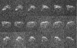
-
PIA16895:
-
Goldstone Radar Images of Asteroid 2013 ET
Full Resolution:
TIFF
(322.3 kB)
JPEG
(65.17 kB)
|
|
|
2013-03-18 |
Mercury
|
MESSENGER
|
MDIS - Narrow Angle
|
1024x1024x1 |
|
-
PIA16899:
-
Terrace View
Full Resolution:
TIFF
(1.05 MB)
JPEG
(112.9 kB)
|
|
|
2013-03-18 |
Mars
|
Mars Science Laboratory (MSL)
|
Dynamic Albedo of Neutrons
|
1440x1080x3 |
|
-
PIA16810:
-
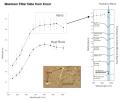
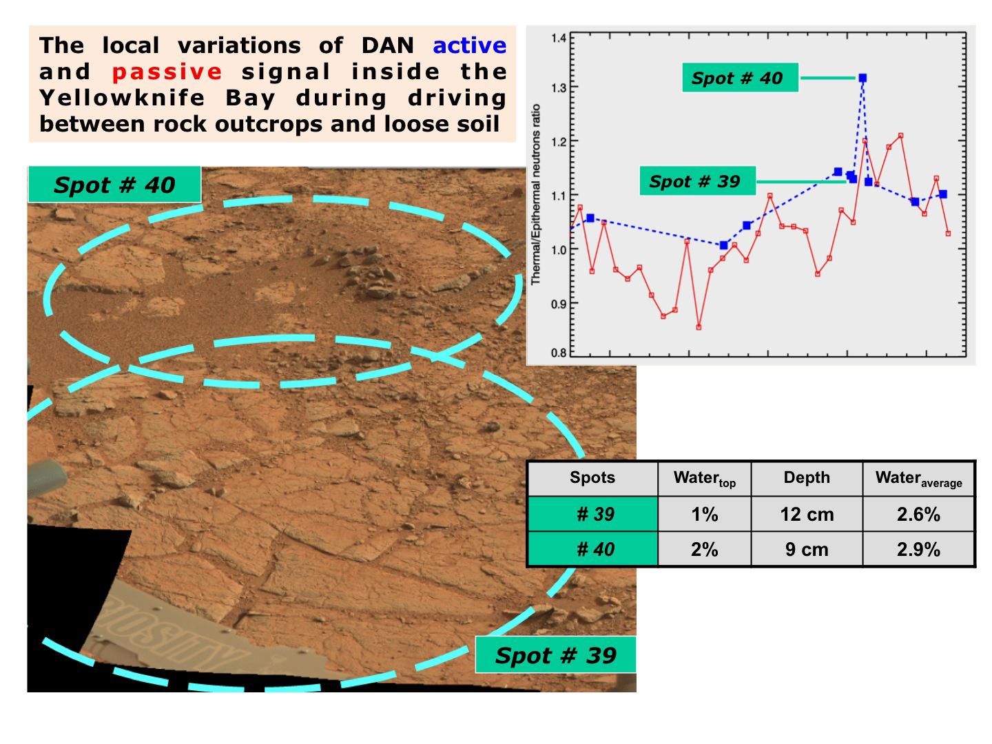
Variation in Subsurface Water In 'Yellowknife Bay'
Full Resolution:
TIFF
(4.668 MB)
JPEG
(206.8 kB)
|
|
|
2013-03-18 |
Mars
|
Mars Science Laboratory (MSL)
|
Dynamic Albedo of Neutrons
|
1440x1080x3 |
|
-
PIA16809:
-
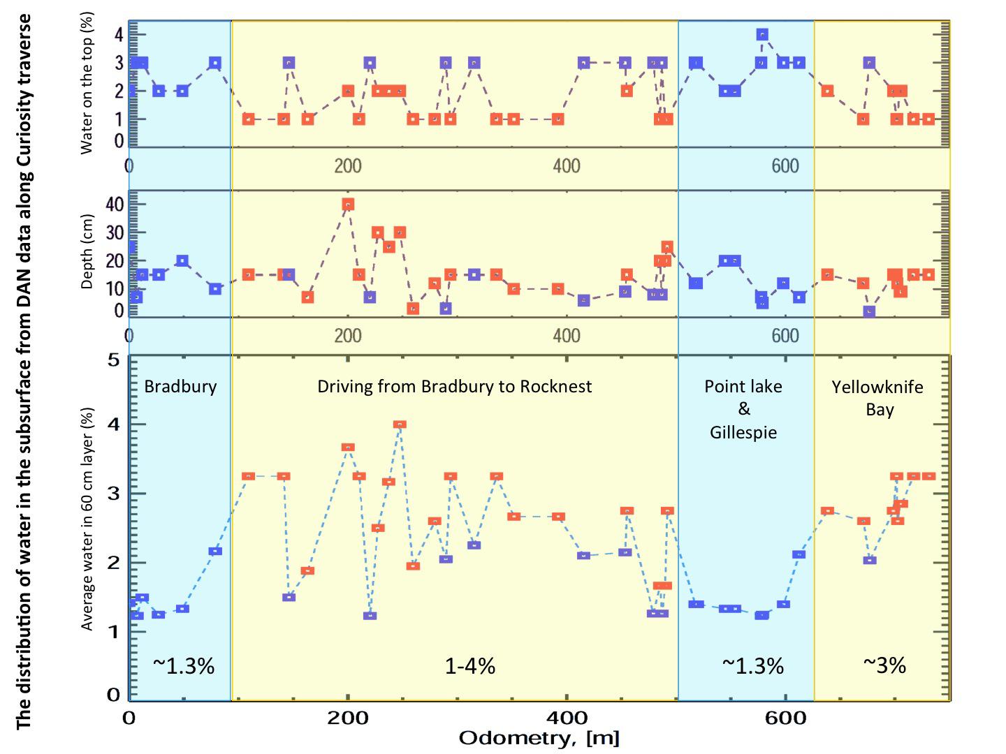
Variation in Water Content in Martian Subsurface Along Curiosity's Traverse
Full Resolution:
TIFF
(4.668 MB)
JPEG
(148 kB)
|
|
|
2013-03-18 |
Mars
|
Mars Science Laboratory (MSL)
|
Dynamic Albedo of Neutrons
|
1440x1080x3 |
|
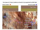
-
PIA16808:
-
Two Types of Modeling of Subsurface Water
Full Resolution:
TIFF
(4.668 MB)
JPEG
(297.3 kB)
|
|
|
2013-03-18 |
Mars
|
Mars Science Laboratory (MSL)
|
Dynamic Albedo of Neutrons
|
1440x1080x3 |

|
-
PIA16807:
-
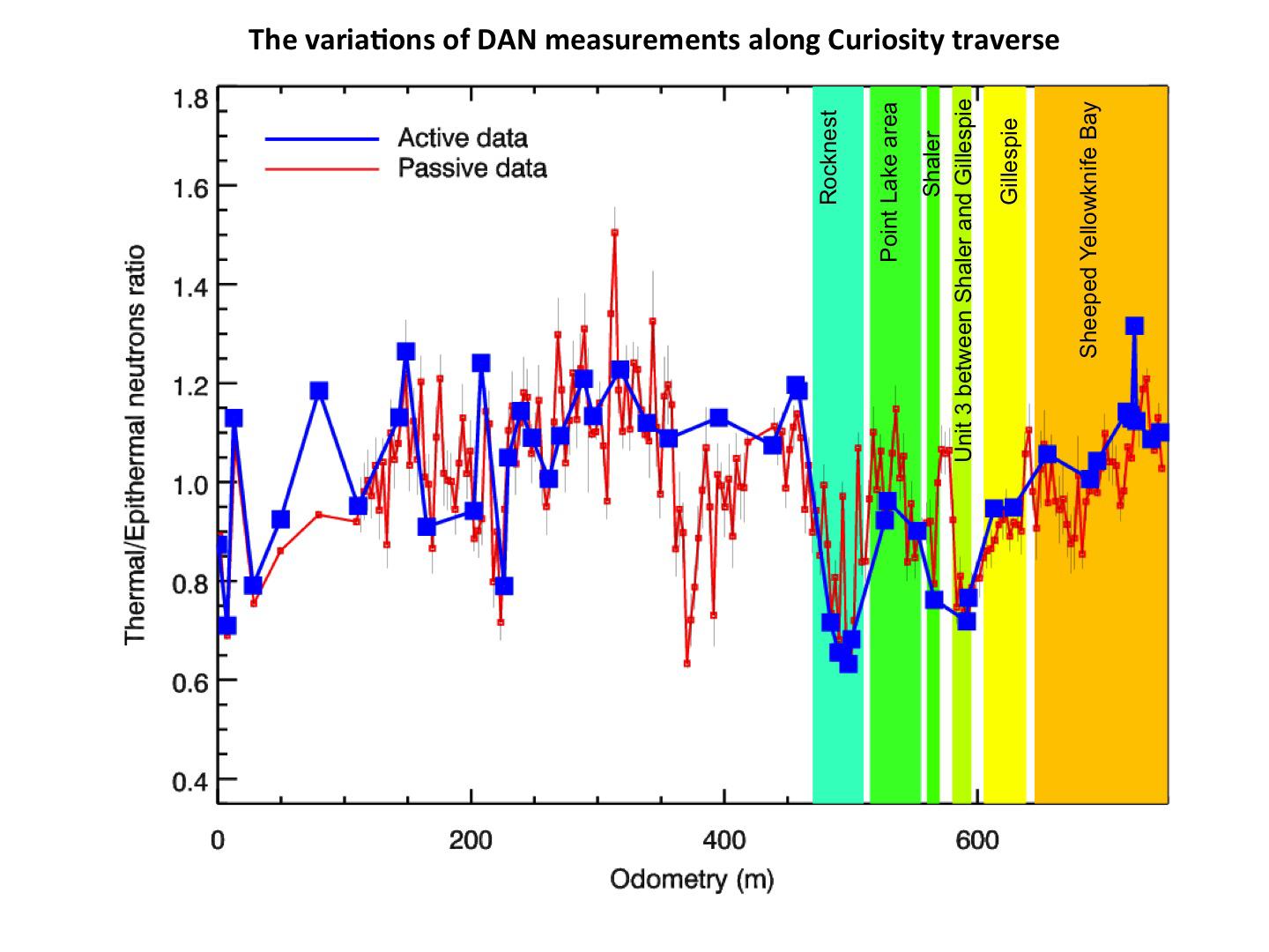
Variations of DAN Measurements Along Curiosity Traverse
Full Resolution:
TIFF
(4.668 MB)
JPEG
(146.1 kB)
|
|
|
2013-03-18 |
Mars
|
Mars Science Laboratory (MSL)
|
Mastcam
|
1150x863x3 |
|
-
PIA16806:
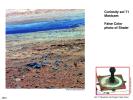
-
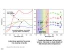
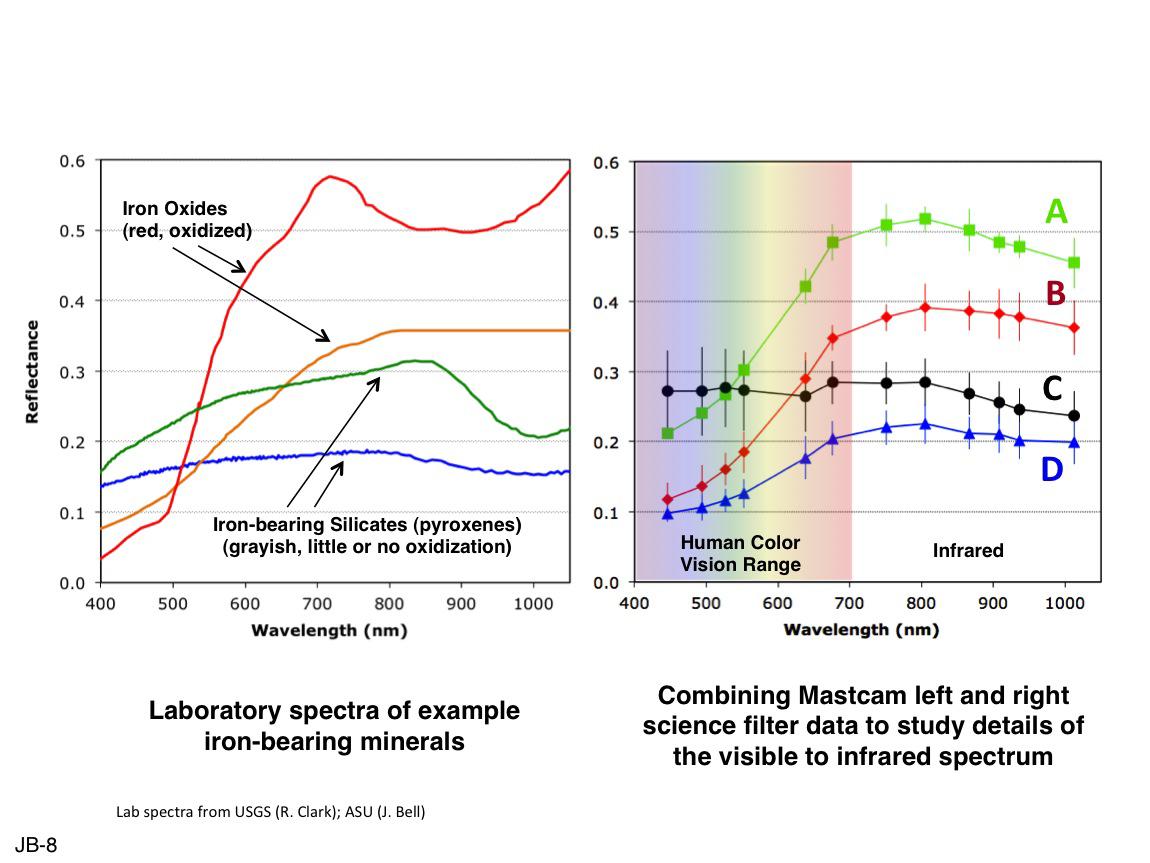
Comparing Mastcam and Laboratory Spectra
Full Resolution:
TIFF
(2.979 MB)
JPEG
(105.7 kB)
|
|
|
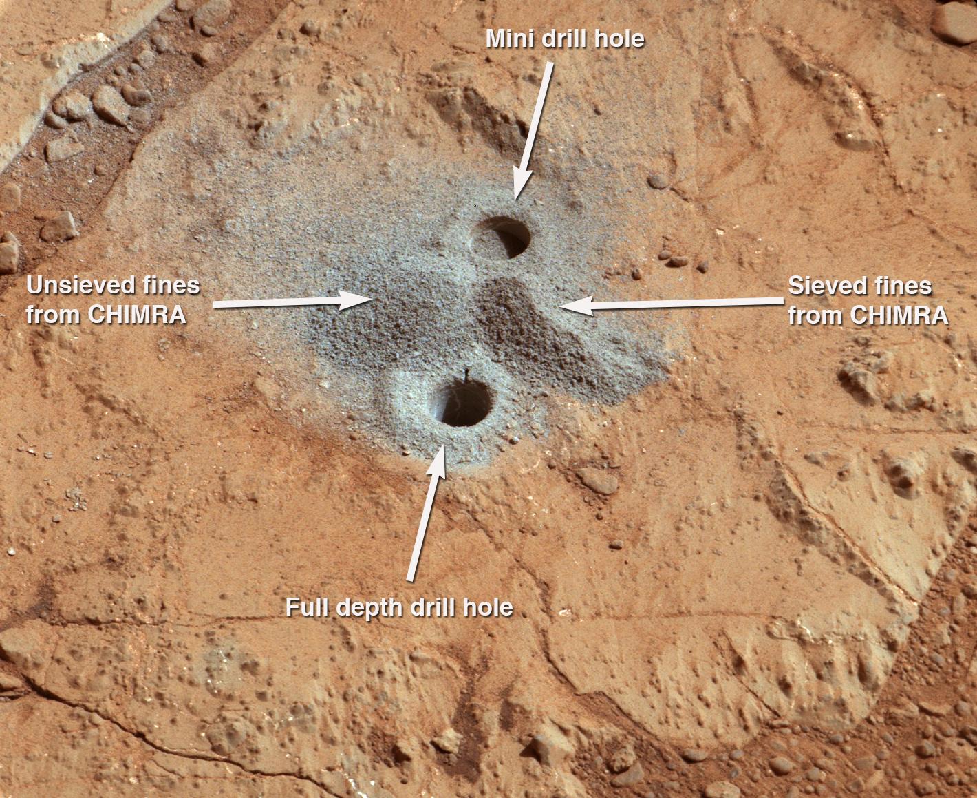
2013-03-18 |
Mars
|
Mars Science Laboratory (MSL)
|
Mastcam
|
1150x863x3 |
|
-
PIA16805:
-
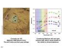
Drill Hole Image and Spectra Acquired by Mastcam
Full Resolution:
TIFF
(2.979 MB)
JPEG
(112.7 kB)
|
|
|
2013-03-18 |
Mars
|
Mars Science Laboratory (MSL)
|
Mastcam
|
1150x1107x3 |
|
-
PIA16804:
-
Bluish Color in Broken Rock in 'Yellowknife Bay'
Full Resolution:
TIFF
(3.821 MB)
JPEG
(219.4 kB)
|
|
|
2013-03-18 |
Mars
|
Mars Science Laboratory (MSL)
|
Mastcam
|
477x384x3 |
|
-
PIA16803:
-
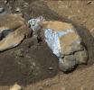
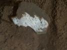
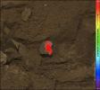
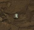
Bluish-Black Rock with White 'Crystals' on Mars
Full Resolution:
TIFF
(549.9 kB)
JPEG
(34.45 kB)
|
|
|
2013-03-18 |
Mars
|
Mars Science Laboratory (MSL)
|
Mastcam
|
1150x863x3 |
|
-
PIA16802:
-
Using False Color from Curiosity's Mast Camera
Full Resolution:
TIFF
(2.979 MB)
JPEG
(174.6 kB)
|
|
|
2013-03-18 |
Mars
|
Mars Science Laboratory (MSL)
|
Mastcam
|
1150x863x3 |
|
-
PIA16801:
-
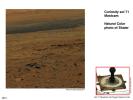
Using Curiosity's Mast Camera to View Scene in 'Natural' Color
Full Resolution:
TIFF
(2.979 MB)
JPEG
(118.6 kB)
|
|
|
2013-03-18 |
Mars
|
Mars Science Laboratory (MSL)
|
Mastcam
|
1150x863x3 |

|
-
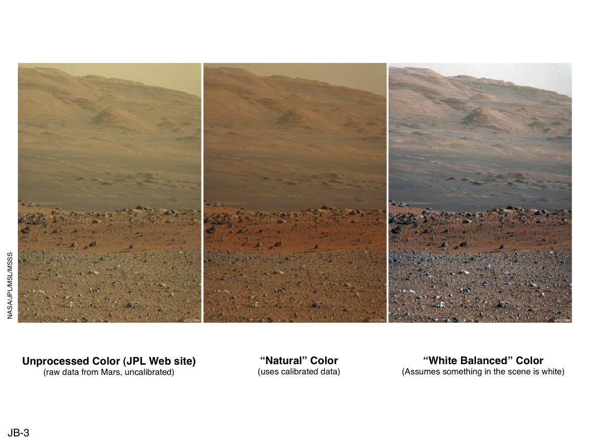
PIA16800:
-
'Raw,' 'Natural' and 'White-Balanced' Views of Martian Terrain
Full Resolution:
TIFF
(2.979 MB)
JPEG
(108 kB)
|
|
|
2013-03-18 |
Mars
|
Mars Science Laboratory (MSL)
|
Mastcam
|
1150x863x3 |

|
-
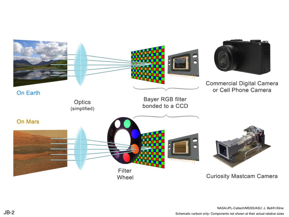
PIA16799:
-
Filters for Color Imaging and for Science
Full Resolution:
TIFF
(2.979 MB)
JPEG
(90.23 kB)
|
|
|
2013-03-18 |
Mars
|
Mars Science Laboratory (MSL)
|
Mastcam
|
1150x863x3 |
|
-
PIA16798:
-
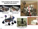
Mast Camera and Its Calibration Target on Curiosity Rover
Full Resolution:
TIFF
(2.979 MB)
JPEG
(158 kB)
|
|
|
2013-03-18 |
Mars
|
Mars Science Laboratory (MSL)
|
MAHLI
|
1584x1184x3 |
|
-
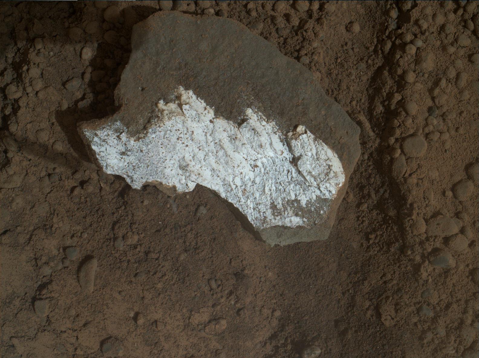
PIA16797:
-
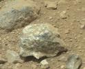
Close-up View of Broken Mars Rock 'Tintina'
Full Resolution:
TIFF
(5.628 MB)
JPEG
(300.5 kB)
|
|
|
2013-03-18 |
Mars
|
Mars Science Laboratory (MSL)
|
Mastcam
|
1344x1200x3 |
|
-
PIA16796:
-
Hydration Map, Based on Mastcam Spectra, for broken rock 'Tintina'
Full Resolution:
TIFF
(4.84 MB)
JPEG
(204.3 kB)
|
|
|
2013-03-18 |
Mars
|
Mars Science Laboratory (MSL)
|
Mastcam
|
1024x914x3 |
|
-
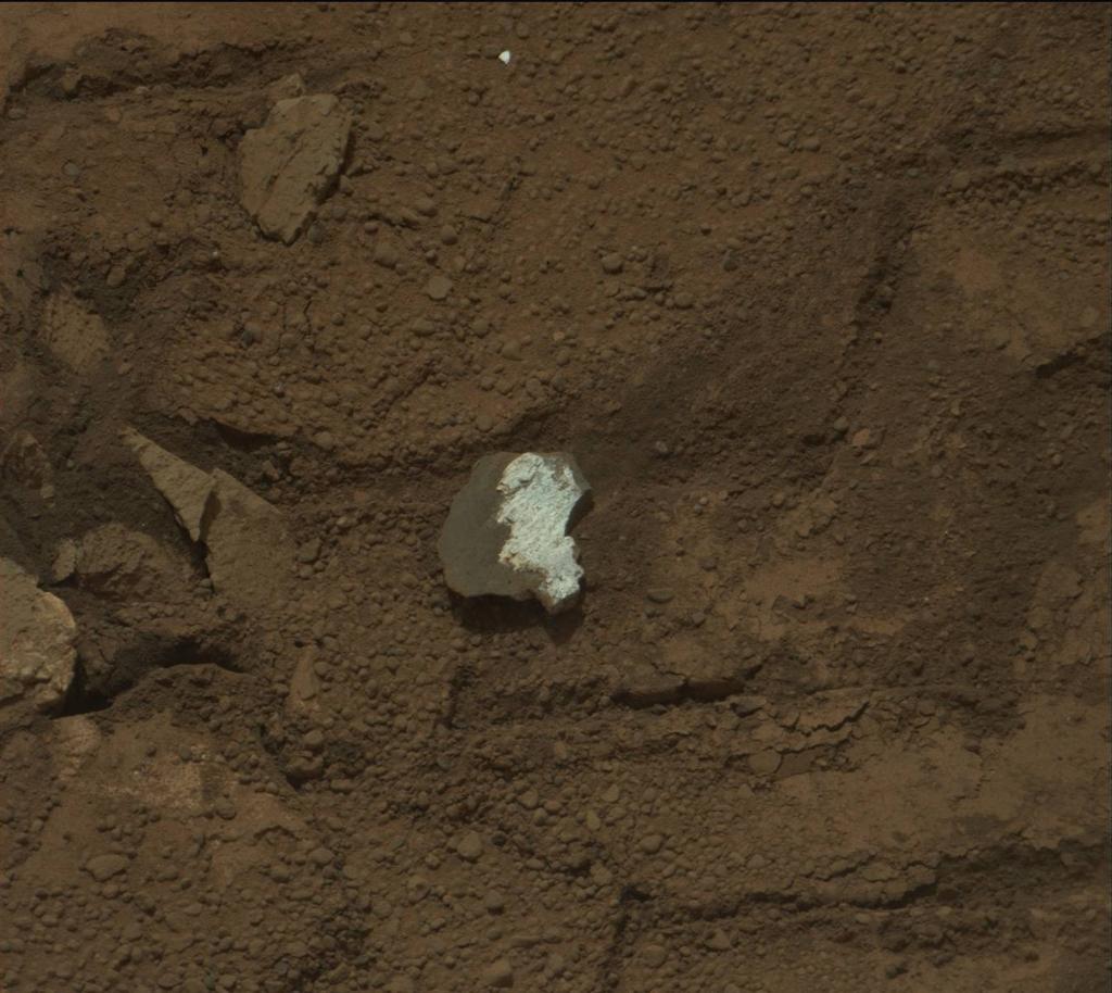
PIA16795:
-
Rock "Tintina" Exposes "Yellowknife Bay" Vein Material
Full Resolution:
TIFF
(2.809 MB)
JPEG
(125.5 kB)
|
|
|
2013-03-18 |
Mars
|
Mars Science Laboratory (MSL)
|
Mastcam
|
1344x1200x3 |
|
-
PIA16794:
-
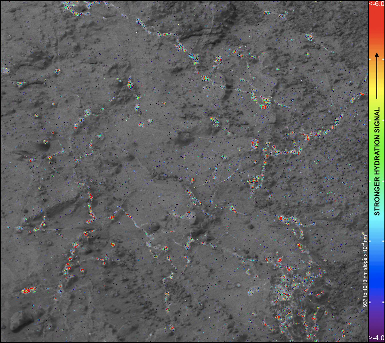
Hydration Map, Based on Mastcam Spectra, for 'Knorr' Rock Target
Full Resolution:
TIFF
(4.84 MB)
JPEG
(288 kB)
|
|
|
2013-03-18 |
Mars
|
Mars Science Laboratory (MSL)
|
Mastcam
|
3000x2400x3 |
|
-
PIA16793:
-
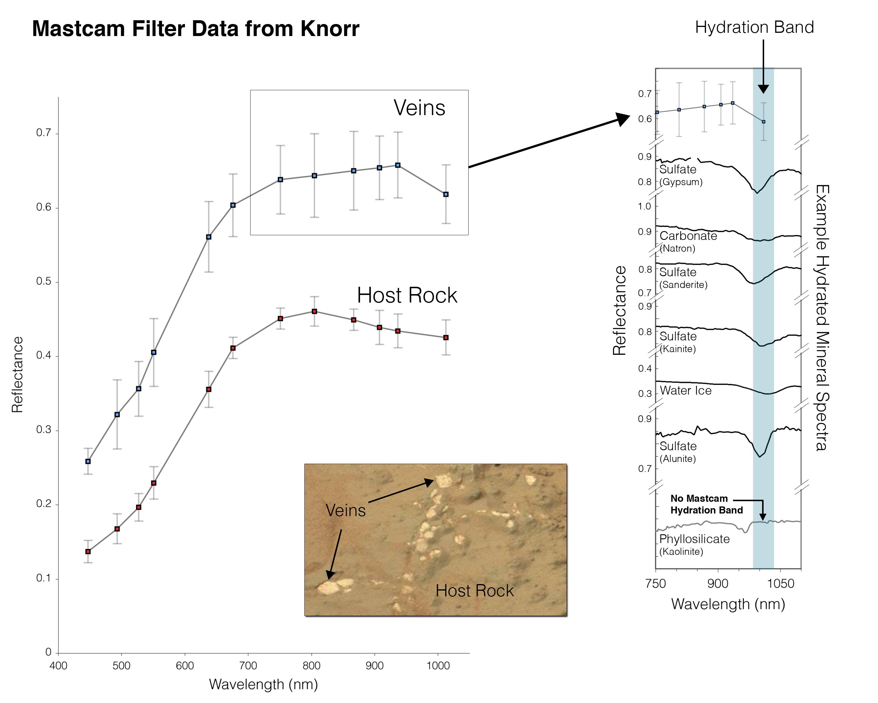
Indication of Hydration in Veins and Nodules of 'Knorr' in 'Yellowknife Bay'
Full Resolution:
TIFF
(21.61 MB)
JPEG
(357.3 kB)
|
 Planetary Data System


