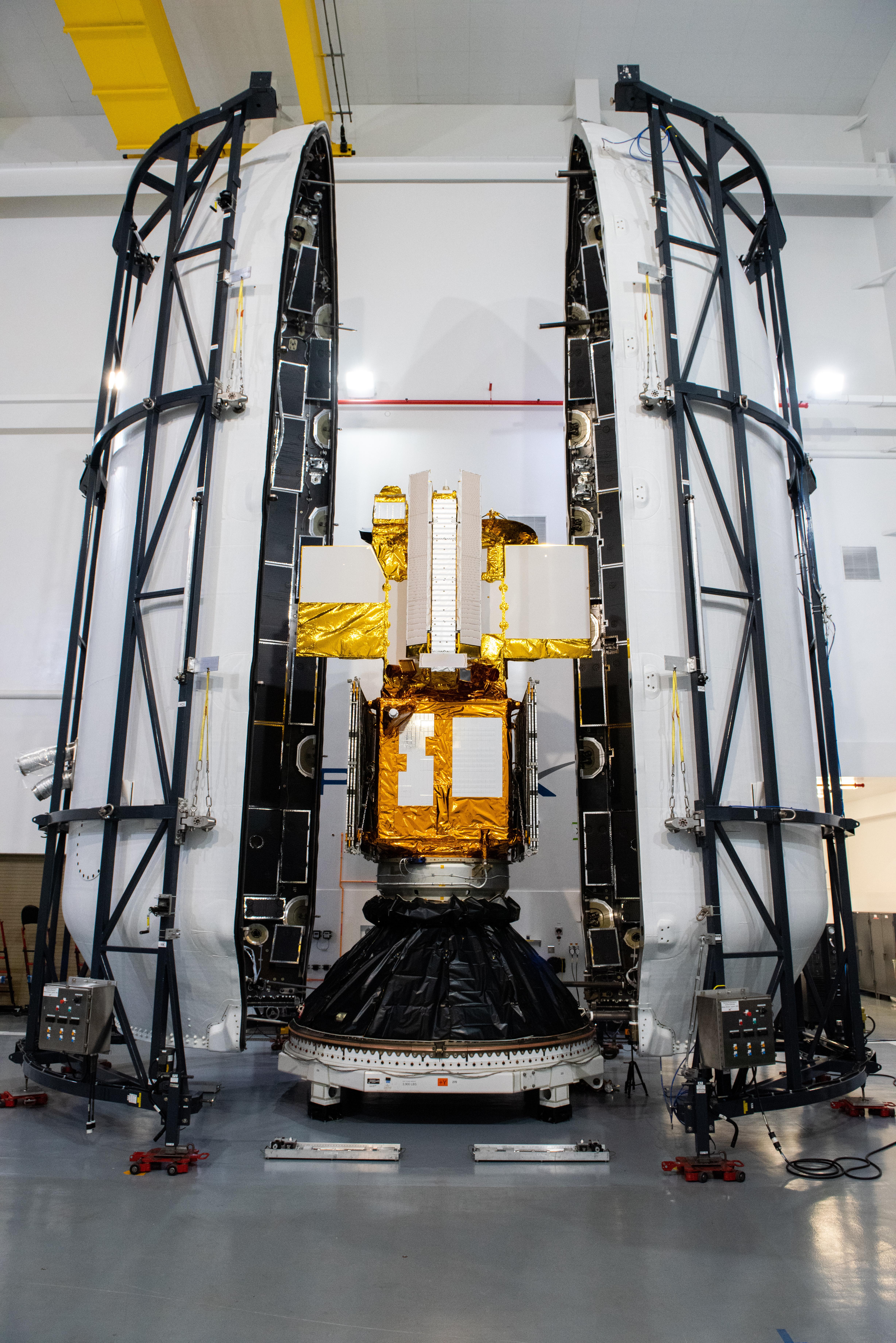
My
List |
Addition Date
|
Target
|
Mission
|
Instrument
|
Size
|

|
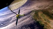
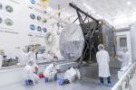
2025-07-22 |
|
NISAR
|
|
8256x5504x3 |

|
-
PIA26611:
-
NISAR Encapsulated in Payload Fairing at ISRO Launch Site
Full Resolution:
TIFF
(93.02 MB)
JPEG
(4.346 MB)
|
|
|
2025-07-21 |
Earth
|
ECOSTRESS
|
ECOSTRESS
|
2480x3507x3 |

|
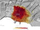
-
PIA26651:
-
NASA's ECOSTRESS Captures Short-Lived Heat Wave in L.A. Area
Full Resolution:
TIFF
(20.57 MB)
JPEG
(1.26 MB)
|
|
|
2025-07-03 |
Earth
|
ECOSTRESS
|
|
3507x2480x3 |

|
-
PIA26190:
-
ECOSTRESS Captures Paris During Europe Heat Wave
Full Resolution:
TIFF
(24.59 MB)
JPEG
(3.007 MB)
|
|
|
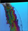
2025-07-03 |
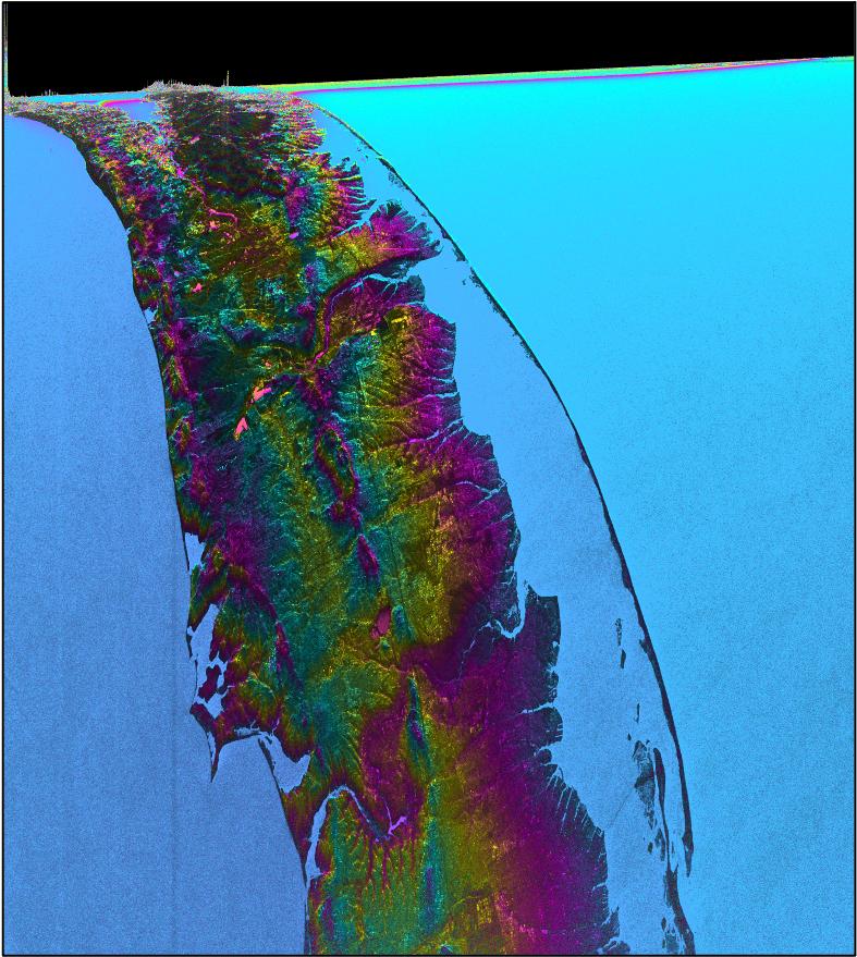
Earth
|
NISAR
|
|
1800x1275x3 |
|
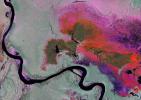
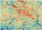
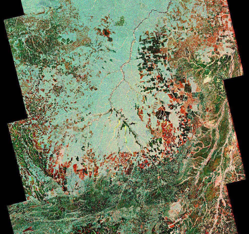
-
PIA26112:
-
Radar Image of Amazonian Flooding Similar to Future NISAR Imagery
Full Resolution:
TIFF
(6.888 MB)
JPEG
(808.4 kB)
|
|
|
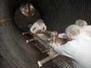
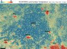
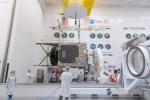
2025-06-12 |
|
NISAR
|
|
5760x3840x3 |

|
-
PIA26500:
-
NISAR Arrives at Indian Launch Site
Full Resolution:
TIFF
(53.84 MB)
JPEG
(1.768 MB)
|
|
|
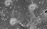
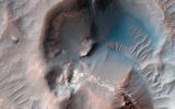
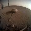
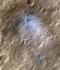
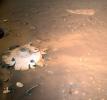
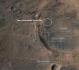
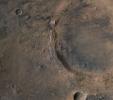
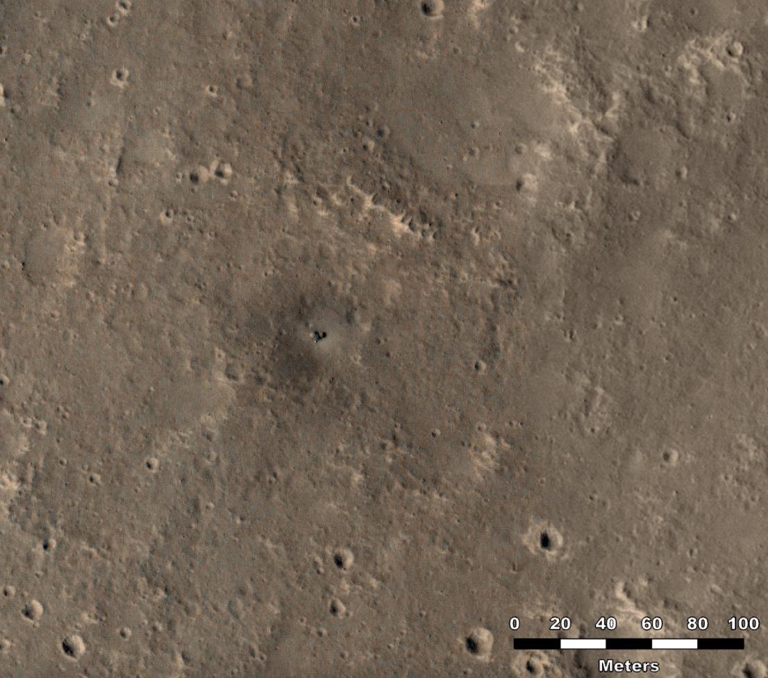
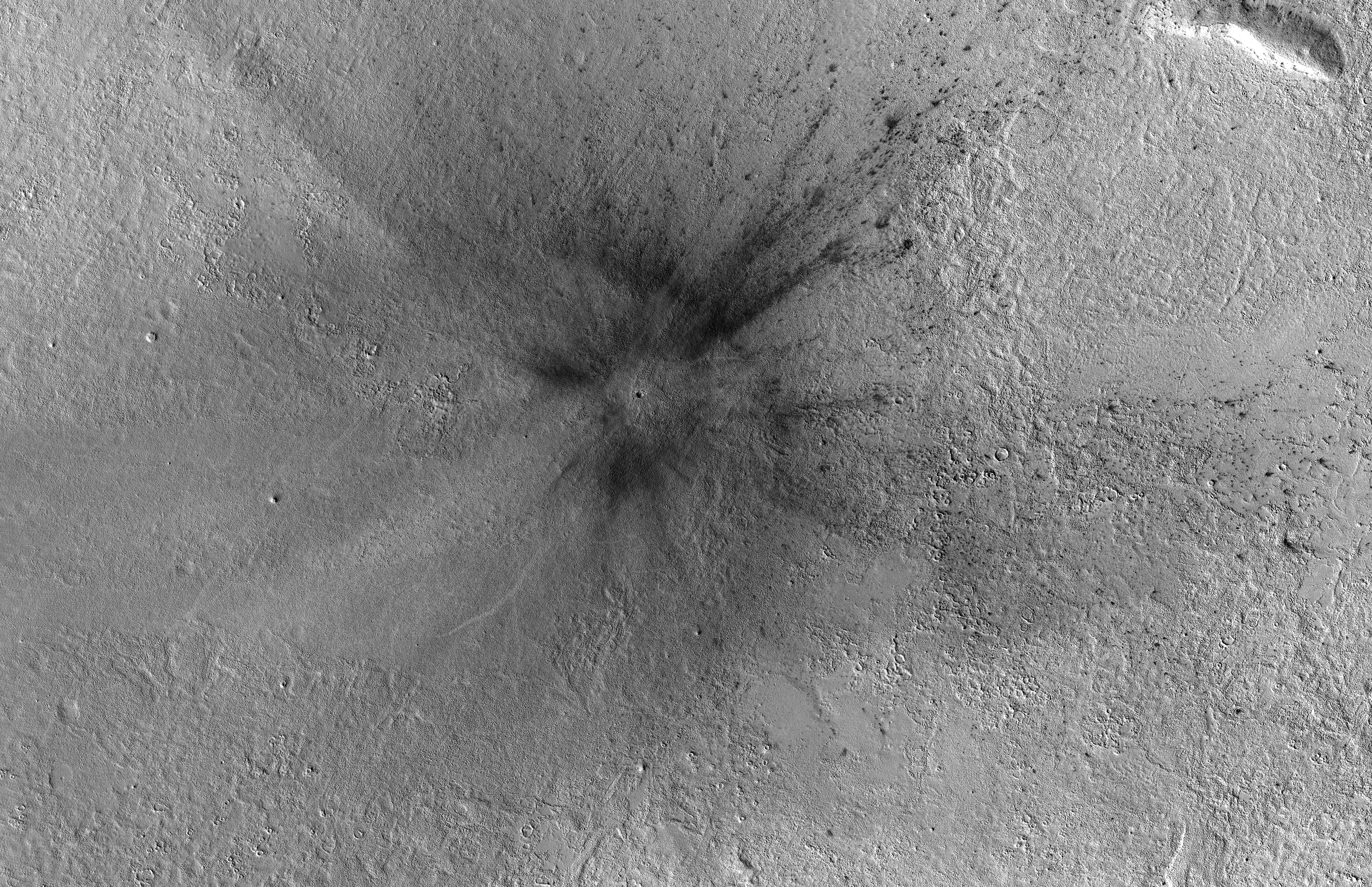
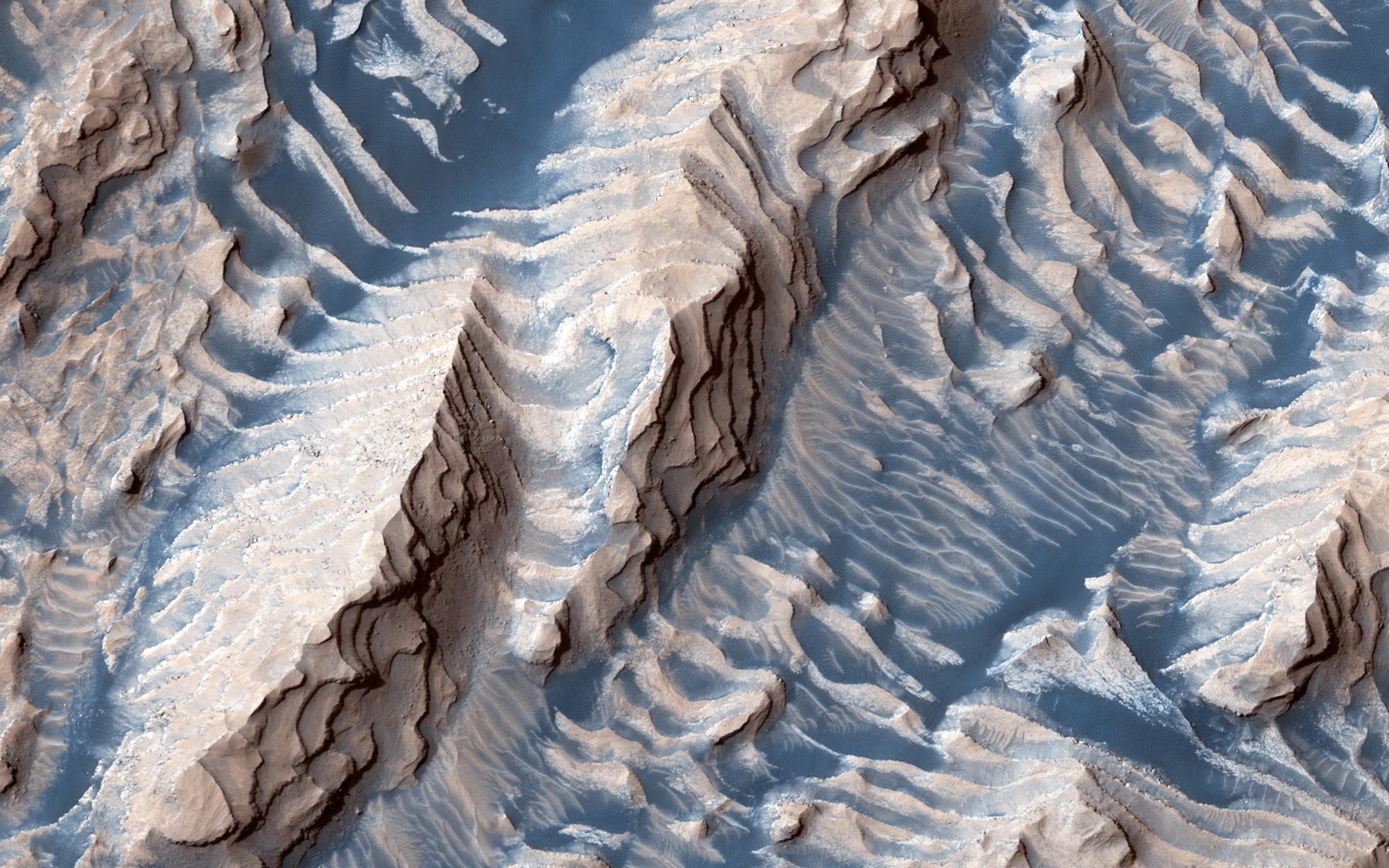
2025-02-03 |
Mars
|
Mars Reconnaissance Orbiter (MRO)
|
HiRISE
|
2560x1920x3 |

|
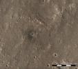
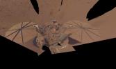
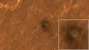
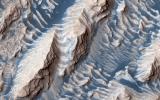
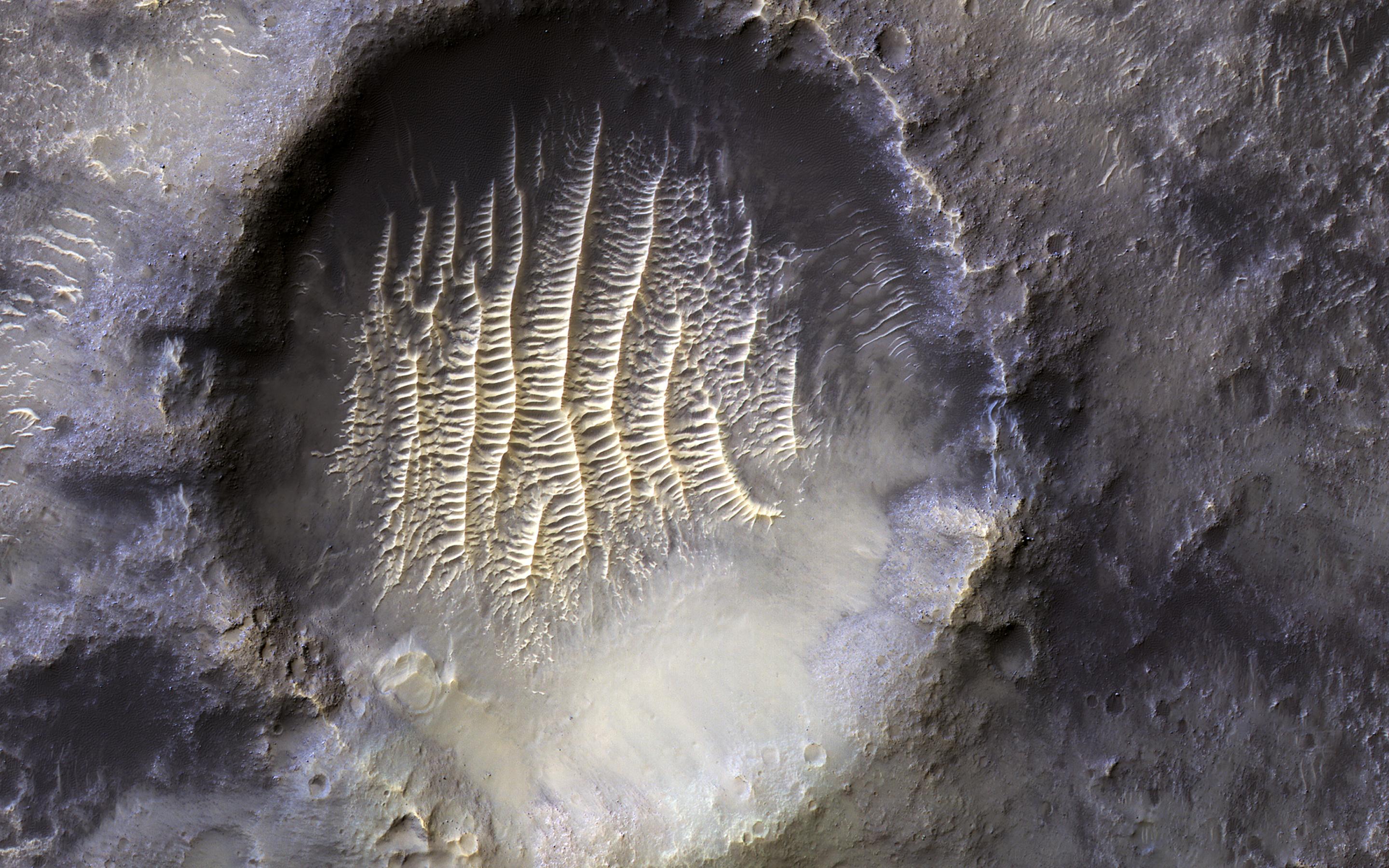
-
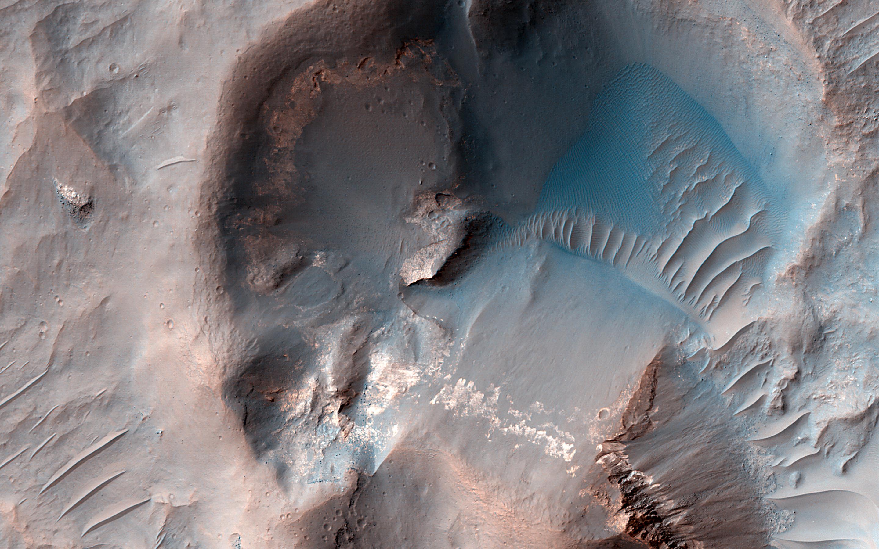
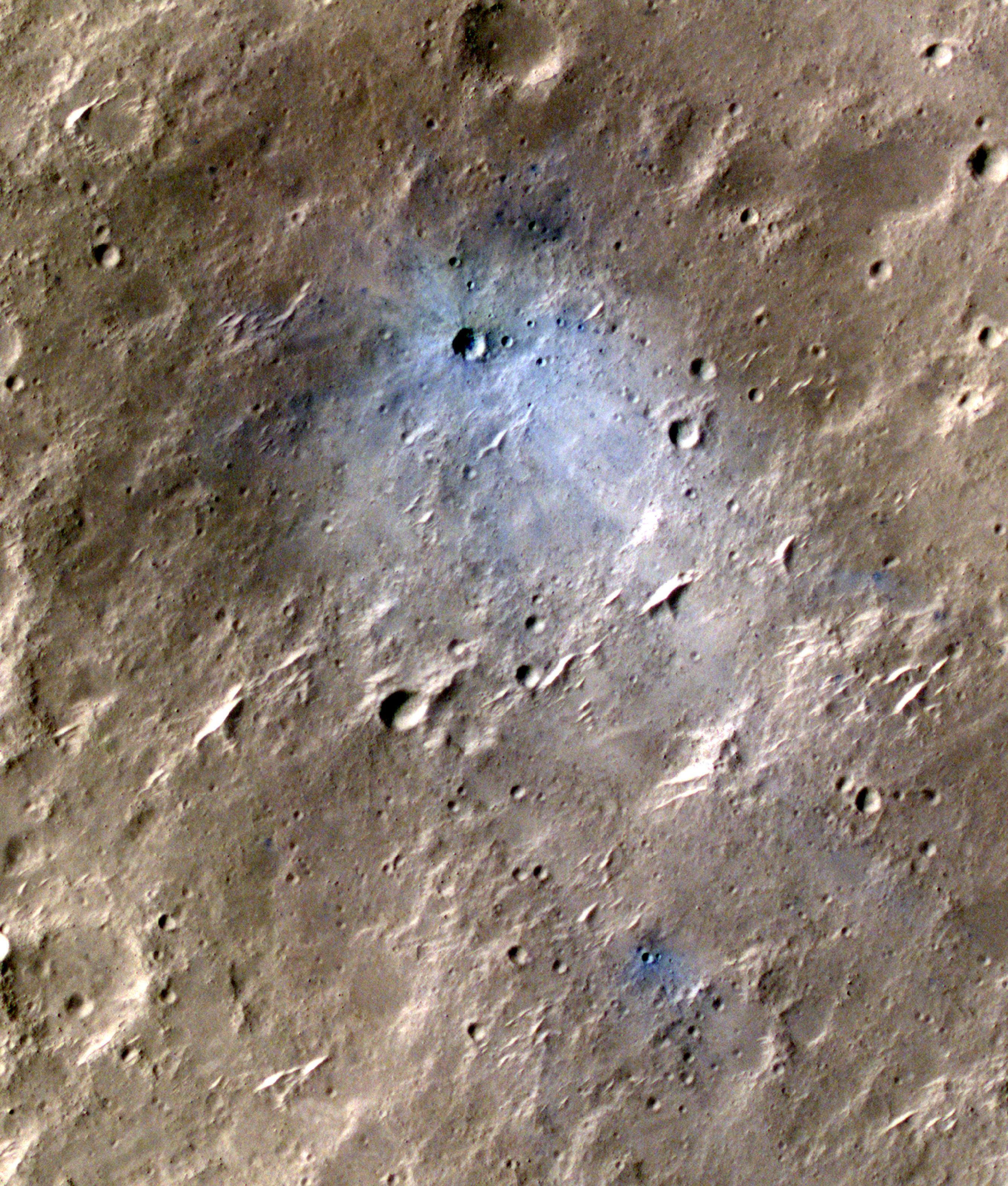
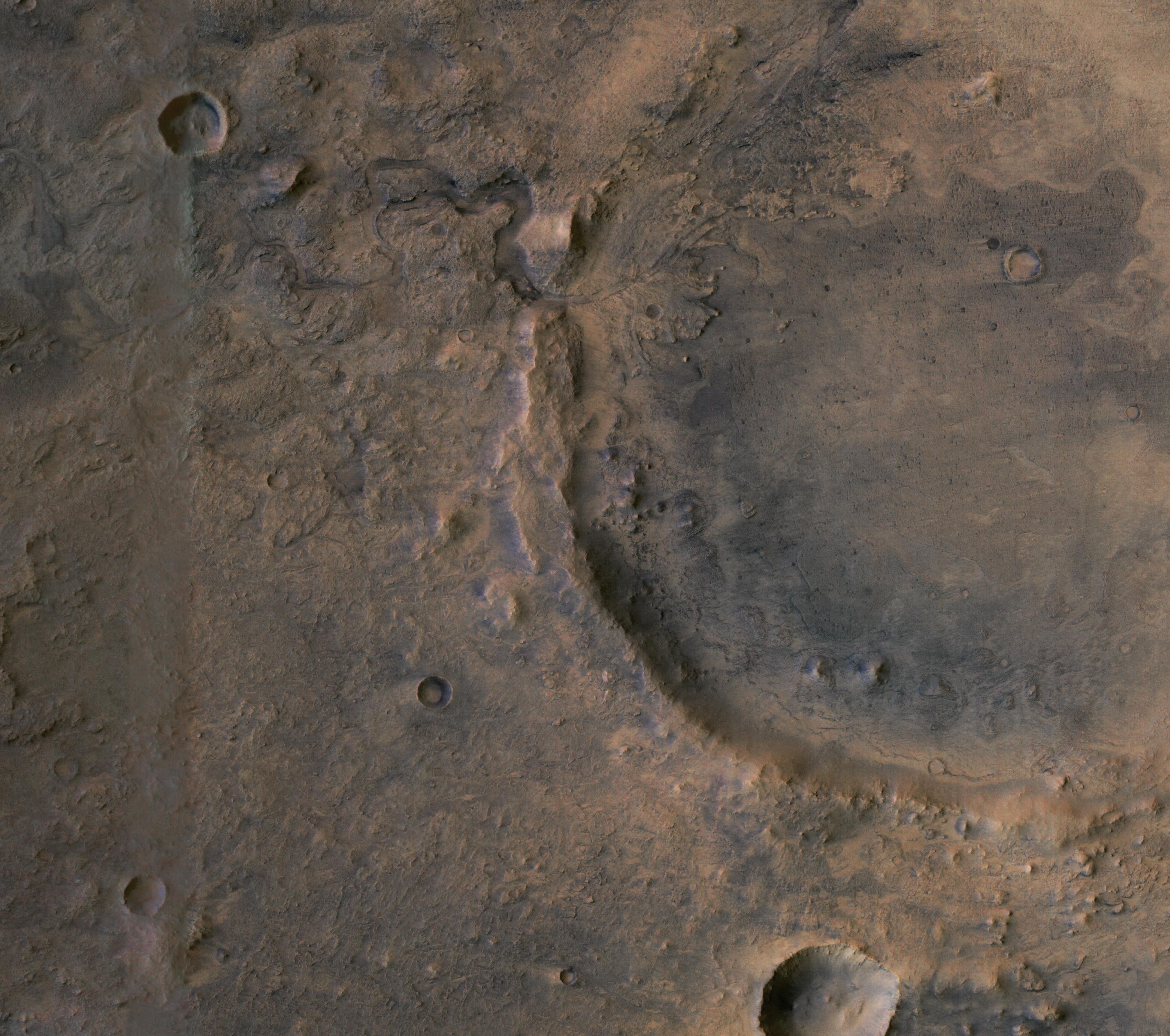
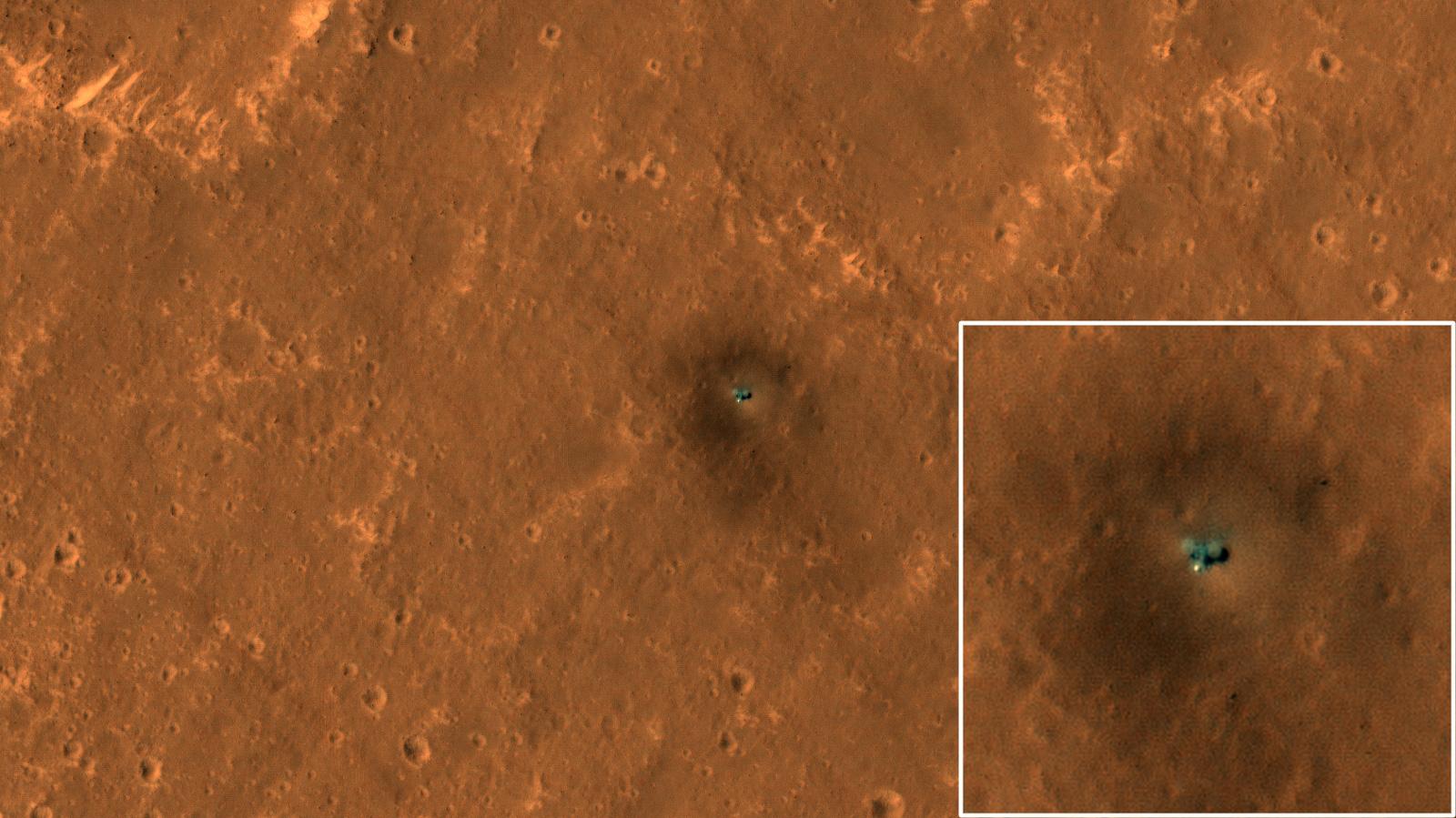
PIA26518:
-
HiRISE Views Impact Crater Matching InSight's Seismic Data
Full Resolution:
TIFF
(14.75 MB)
JPEG
(922.8 kB)
|
|
|
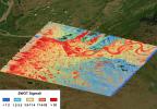
2025-01-31 |
Earth
|
|
UAVSAR
|
1440x1090x3 |
|
-
PIA26495:
-
NASA Radar Looks at Palos Verdes Landslides
Full Resolution:
TIFF
(2.762 MB)
JPEG
(259.6 kB)
|
|
|
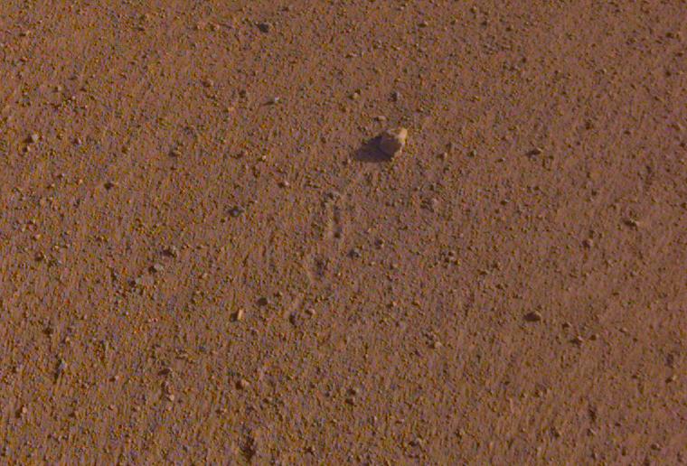
2024-12-16 |
Mars
|
Mars Reconnaissance Orbiter (MRO)
|
HiRISE
|
1106x977x3 |
|
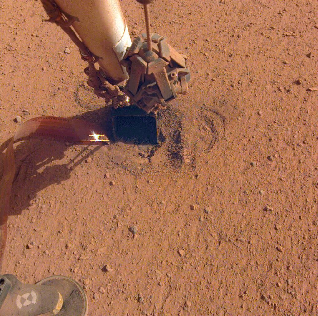
-
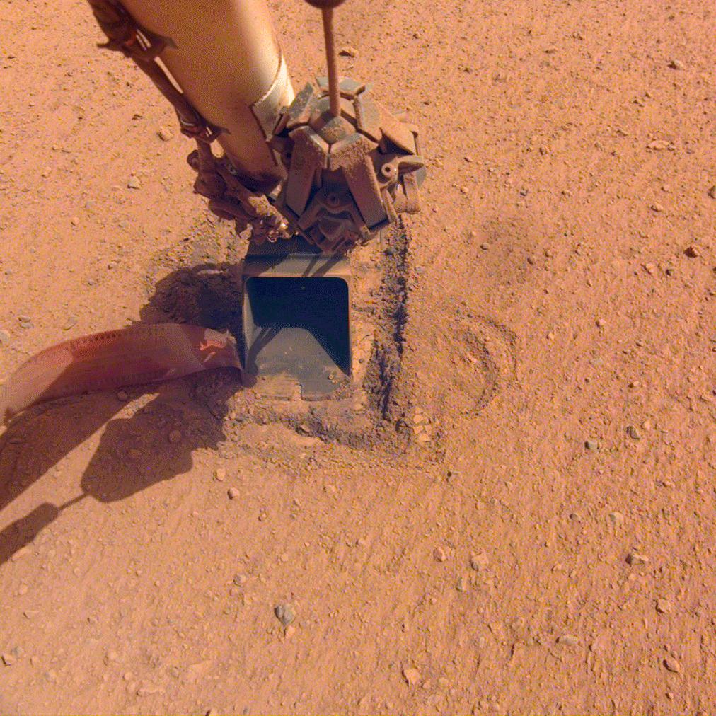
PIA26515:
-
HiRISE Studies the Dust on InSight
Full Resolution:
TIFF
(2.767 MB)
JPEG
(148.6 kB)
|
|
|
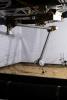
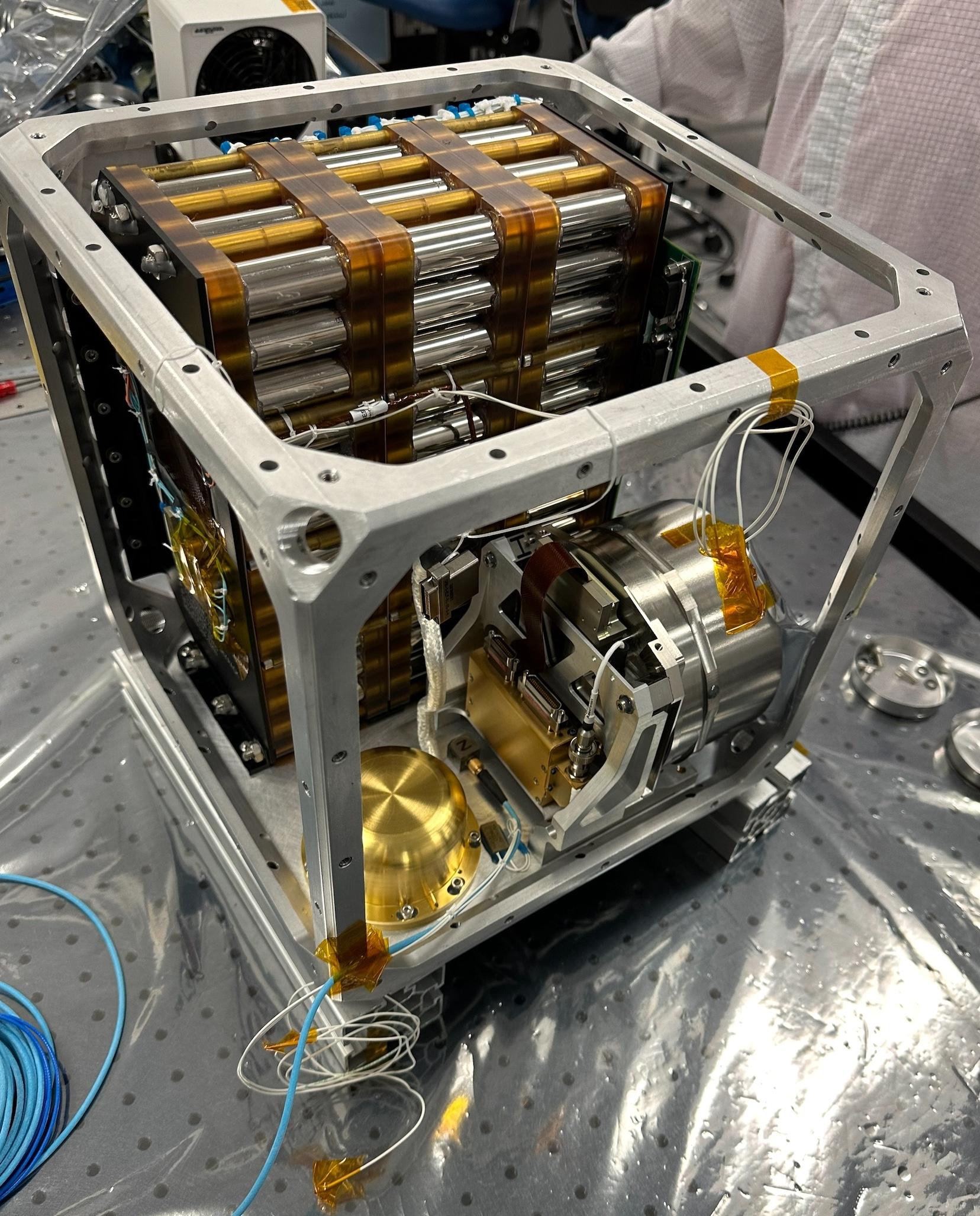
2024-10-29 |
Moon
|
|
Cold Operable Lunar Deployable Arm (COLDArm)
|
3840x2160x3 |
|
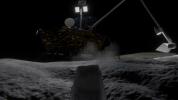
-
PIA26347:
-
NASA's COLDArm Operating on the Moon (Animation)
Full Resolution:
TIFF
(8.895 MB)
JPEG
(369.9 kB)
|
|
|
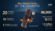
2024-06-27 |
Mars
|
2001 Mars Odyssey
|
THEMIS
|
1920x1080x3 |
|
-
PIA26361:
-
Odyssey's Accomplishments at Its 100,000th Orbit
Full Resolution:
TIFF
(5.213 MB)
JPEG
(209.6 kB)
|
|
|
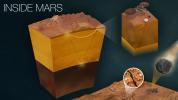
2024-05-29 |
|
|
Farside Seismic Suite (FSS)
|
1656x2055x3 |
|
-
PIA26300:
-
Farside Seismic Suite's Cube Within a Cube
Full Resolution:
TIFF
(10.12 MB)
JPEG
(481.6 kB)
|
|
|
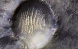
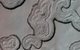
2024-03-26 |
Mars
|
Mars Reconnaissance Orbiter (MRO)
|
HiRISE
|
2880x1800x3 |
|
-
PIA26324:
-
Searching for Distant Secondary Craters
Full Resolution:
TIFF
(15.56 MB)
JPEG
(1.134 MB)
|
|
|
2024-03-26 |
Mars
|
Mars Reconnaissance Orbiter (MRO)
|
HiRISE
|
2880x1800x3 |
|
-
PIA26321:
-
Mars Mysteries: Unveiling the Icy Craters
Full Resolution:
TIFF
(12.88 MB)
JPEG
(730.7 kB)
|
|
|
2024-02-20 |
|
NISAR
|
|
3840x2160x3 |
|
-
PIA26285:
-
NISAR Satellite in Earth Orbit (Artist's Concept)
Full Resolution:
TIFF
(24.89 MB)
JPEG
(1.18 MB)
|
|
|
2023-12-20 |
Moon
|
|
Cold Operable Lunar Deployable Arm (COLDArm)
|
8272x6200x3 |
|
-
PIA26162:
-
NASA's COLDArm in Thermal Vacuum Testing
Full Resolution:
TIFF
(131.8 MB)
JPEG
(8.23 MB)
|
|
|
2023-12-19 |
Mars
|
Mars Reconnaissance Orbiter (MRO)
|
HiRISE
|
2880x1800x3 |
|
-
PIA25987:
-
Muddy Mounds
Full Resolution:
TIFF
(5.191 MB)
JPEG
(1.613 MB)
|
|
|
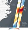
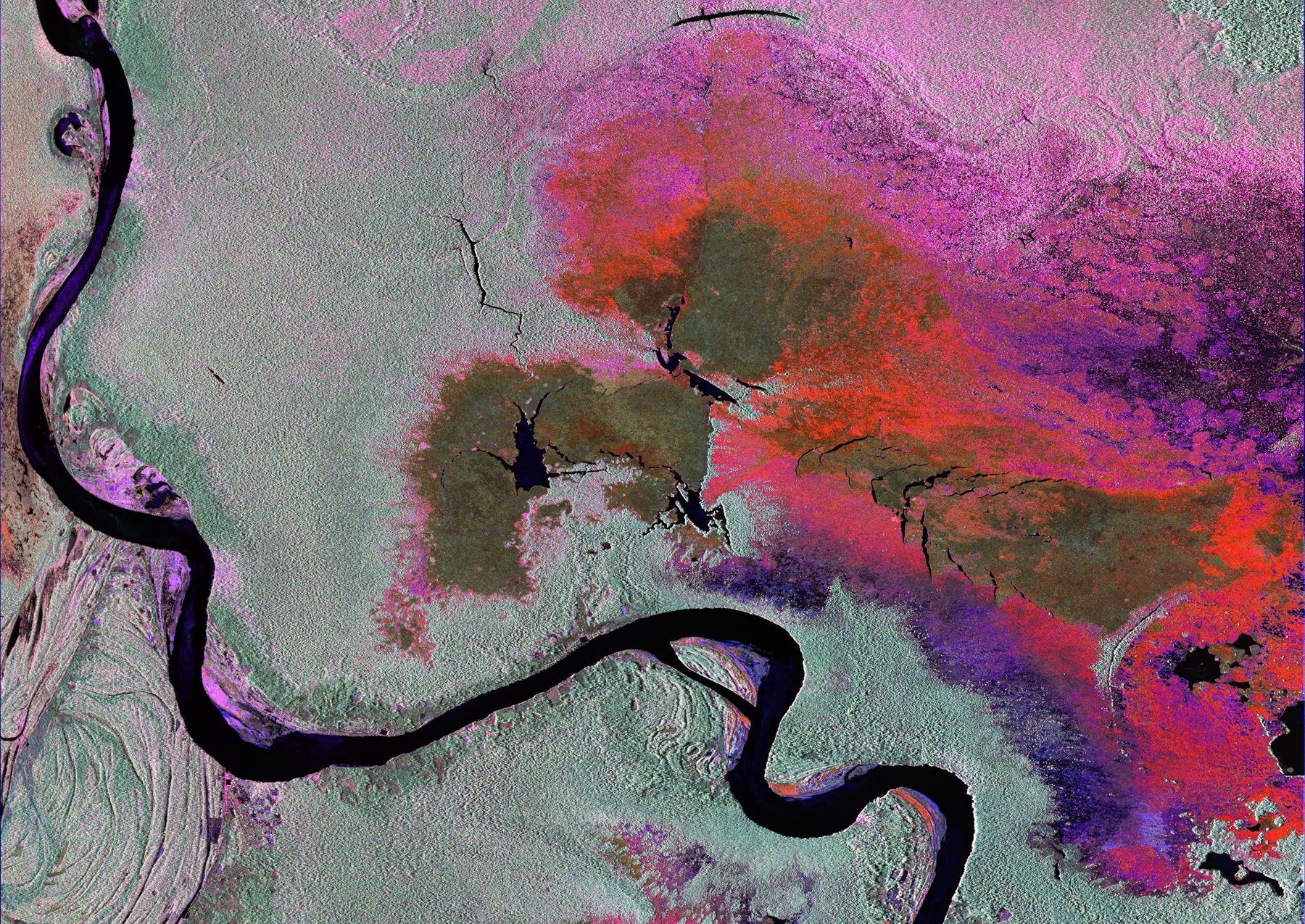
2023-10-27 |
Earth
|
NISAR
|
|
973x913x3 |
|
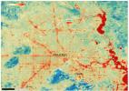
-
PIA26111:
-
Composite of Brazil's 'Arc of Deforestation' Shows Imagery NISAR Will Produce
Full Resolution:
TIFF
(2.666 MB)
JPEG
(396.6 kB)
|
|
|
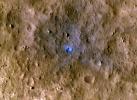
2023-10-26 |
Mars
|
|
|
2852x1169x3 |
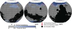
|
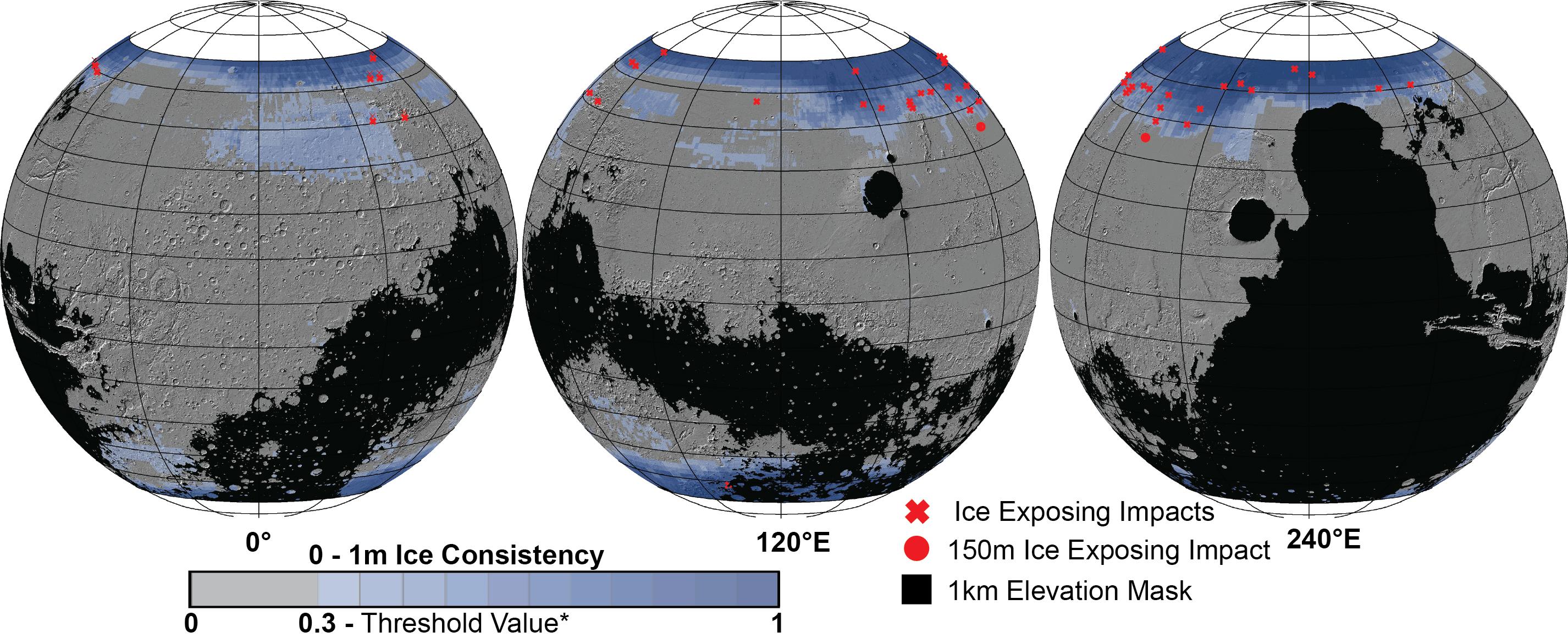
-
PIA26046:
-
Distribution of Buried Ice on Mars
Full Resolution:
TIFF
(3.622 MB)
JPEG
(582.8 kB)
|
|
|
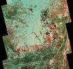
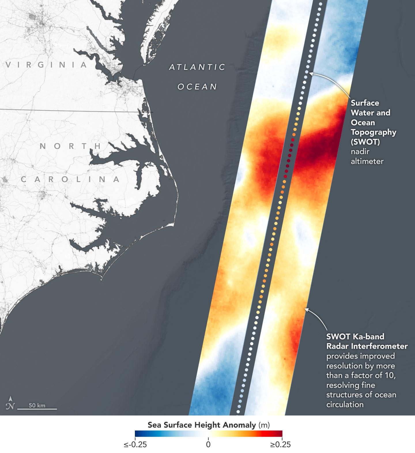
2023-08-30 |
Earth
|
Surface Water and Ocean Topography (SWOT)
|
KaRIn
|
2794x1934x3 |
|
-
PIA25780:
-
SWOT Captures the Yukon River in Alaska
Full Resolution:
TIFF
(16.22 MB)
JPEG
(1.293 MB)
|
|
|
2023-04-24 |
Mars
|
InSight
|
|
1591x1718x3 |
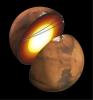
|
-
PIA25827:
-
InSight Detects Quakes That Entered Martian Core (Artist's Concept)
Full Resolution:
TIFF
(4.052 MB)
JPEG
(188.3 kB)
|
|
|
2023-04-13 |
Mars
|
Mars Reconnaissance Orbiter (MRO)
|
HiRISE
|
2880x1800x3 |
|
-
PIA25897:
-
Looking at the Crater Half Full
Full Resolution:
TIFF
(15.56 MB)
JPEG
(644.2 kB)
|
|
|
2023-03-24 |
Earth
|
Surface Water and Ocean Topography (SWOT)
|
KaRIn
|
787x879x3 |
|
-
PIA25774:
-
SWOT Satellite's Land 'First Light'
Full Resolution:
TIFF
(2.076 MB)
JPEG
(135.1 kB)
|
|
|
2023-03-24 |
Earth
|
|
|
1440x1570x3 |

|
-
PIA25773:
-
Sea Level Visualization of Gulf Stream
Full Resolution:
TIFF
(2.24 MB)
JPEG
(159 kB)
|
|
|
2023-03-24 |
Earth
|
Surface Water and Ocean Topography (SWOT)
|
KaRIn
|
1440x1570x3 |
|
-
PIA25772:
-
SWOT Satellite's Sea Level 'First Light'
Full Resolution:
TIFF
(2.873 MB)
JPEG
(182.2 kB)
|
|
|
2022-12-21 |
Mars
|
InSight
|
|
1024x1024x3 |
|
-
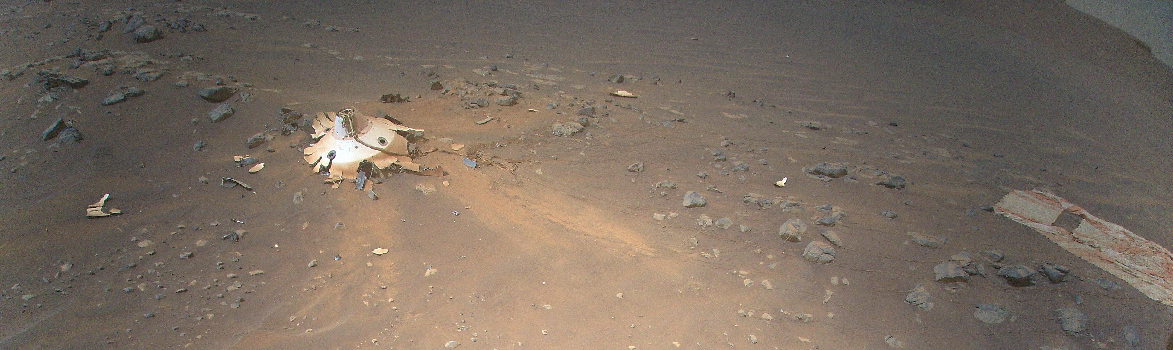
PIA25680:
-
One of InSight's Last Images
Full Resolution:
TIFF
(2.775 MB)
JPEG
(107.5 kB)
|
|
|
2022-12-09 |
|
Surface Water and Ocean Topography (SWOT)
|
|
4912x7360x3 |
|
-
PIA25627:
-
SWOT Spacecraft Encapsulated in Payload Fairing
Full Resolution:
TIFF
(90.28 MB)
JPEG
(7.032 MB)
|
|
|
2022-12-05 |
Moon
|
|
Cold Operable Lunar Deployable Arm (COLDArm)
|
8256x5504x3 |

|
-
PIA25318:
-
Close-Up on COLDArm's Titanium 3D-Printed Scoop
Full Resolution:
TIFF
(83.65 MB)
JPEG
(3.662 MB)
|
|
|
2022-12-05 |
Moon
|
|
Cold Operable Lunar Deployable Arm (COLDArm)
|
5504x8256x3 |
|
-
PIA25317:
-
NASA's COLDArm at Lunar Regolith Simulant Test Bed
Full Resolution:
TIFF
(73.9 MB)
JPEG
(2.899 MB)
|
|
|
2022-12-05 |
Moon
|
|
Cold Operable Lunar Deployable Arm (COLDArm)
|
8256x5504x3 |

|
-
PIA25316:
-
Testing NASA's Cold Operable Lunar Deployable Arm (COLDArm)
Full Resolution:
TIFF
(86.02 MB)
JPEG
(3.31 MB)
|
|
|
2022-11-14 |
Earth
|
Surface Water and Ocean Topography (SWOT)
|
|
1920x1080x3 |
|
-
PIA25561:
-
SWOT Satellite will Improve Clarity and Detail of Sea Height Measurements
Full Resolution:
TIFF
(3.673 MB)
JPEG
(154 kB)
|
|
|
2022-10-27 |
Mars
|
Mars Reconnaissance Orbiter (MRO)
|
CTX
|
5448x3523x1 |

|
-
PIA25584:
-
Context Camera Views an Impact Crater in Amazonis Planitia
Full Resolution:
TIFF
(19.22 MB)
JPEG
(5.28 MB)
|
|
|
2022-10-27 |
Mars
|
InSight
|
|
976x942x3 |

|
-
PIA25582:
-
NASA's InSight Records the Sound of a Martian Impact
Full Resolution:
TIFF
(2.466 MB)
JPEG
(47.12 kB)
|
|
|
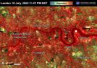
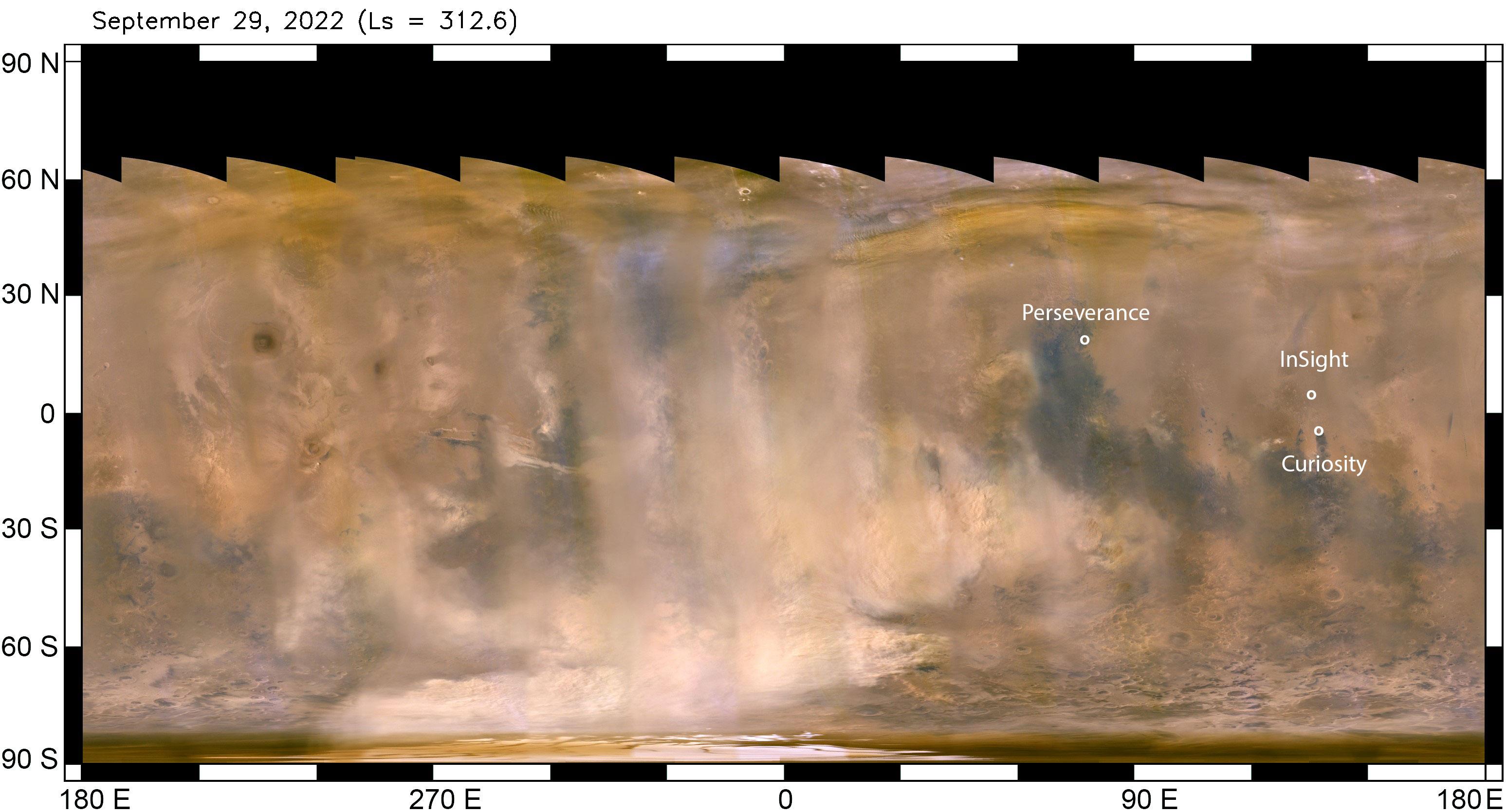
2022-10-07 |
Mars
|
Mars Reconnaissance Orbiter (MRO)
|
MARCI
|
3094x1669x3 |
|
-
PIA25412:
-
Mars Dust Storm in Relation to InSight, Curiosity and Perseverance
Full Resolution:
TIFF
(9.951 MB)
JPEG
(452.4 kB)
|
|
|
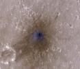
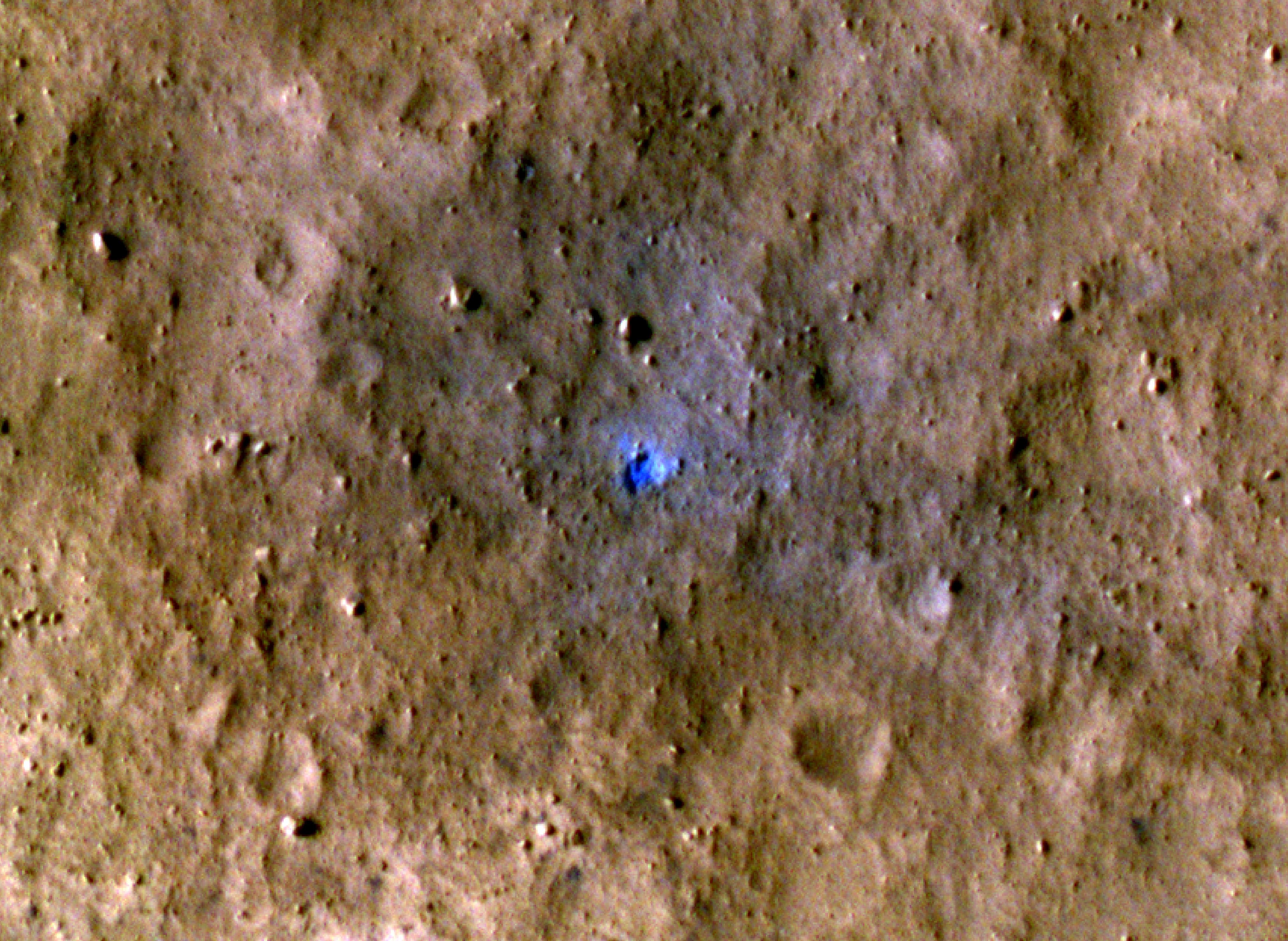
2022-09-19 |
Mars
|
Mars Reconnaissance Orbiter (MRO)
|
HiRISE
|
4047x2956x3 |
|
-
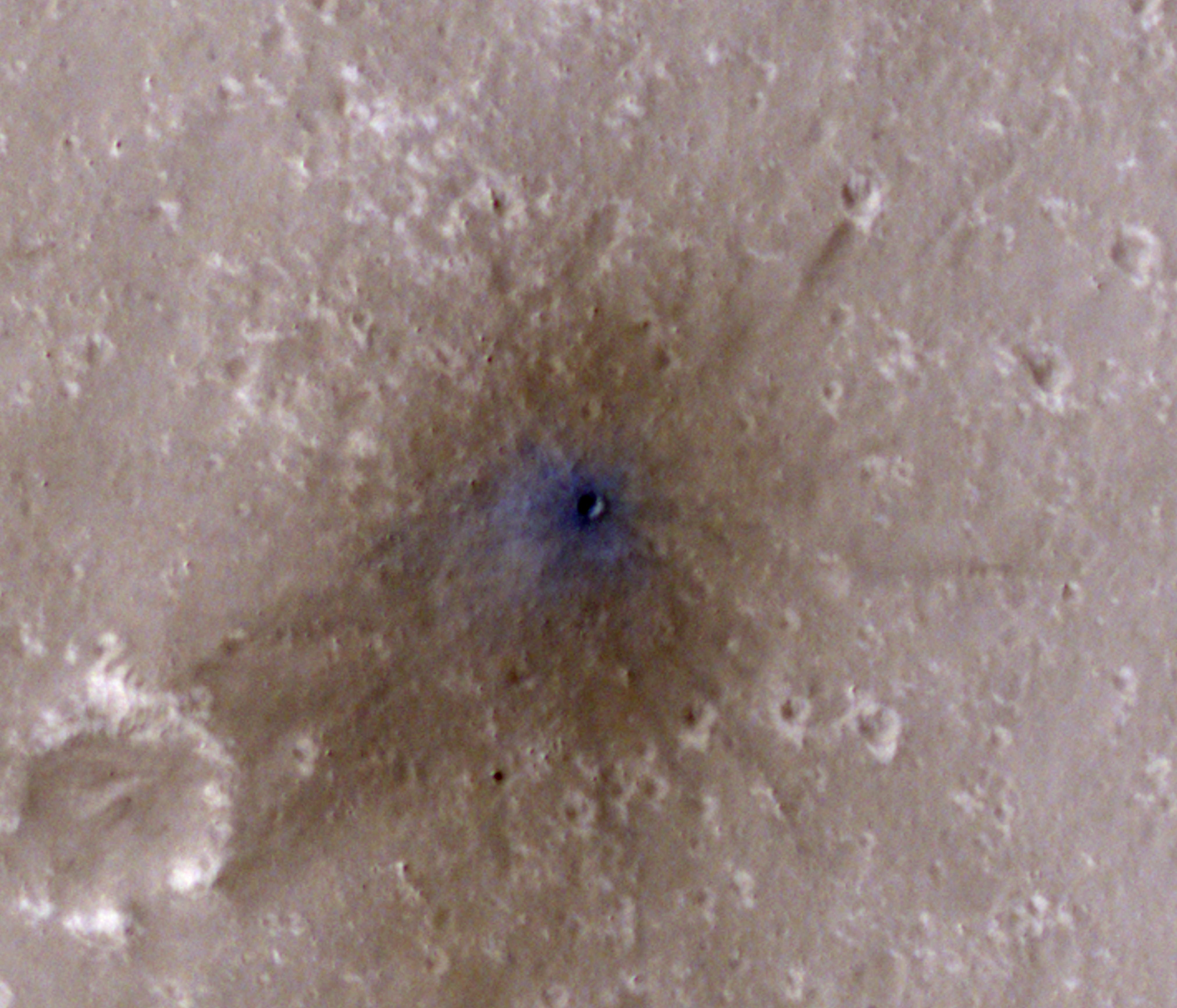
PIA25411:
-
InSight-Detected Impact in August 2021
Full Resolution:
TIFF
(35.9 MB)
JPEG
(1.611 MB)
|
|
|
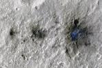
2022-09-19 |
Mars
|
Mars Reconnaissance Orbiter (MRO)
|
HiRISE
|
2675x3147x3 |
|
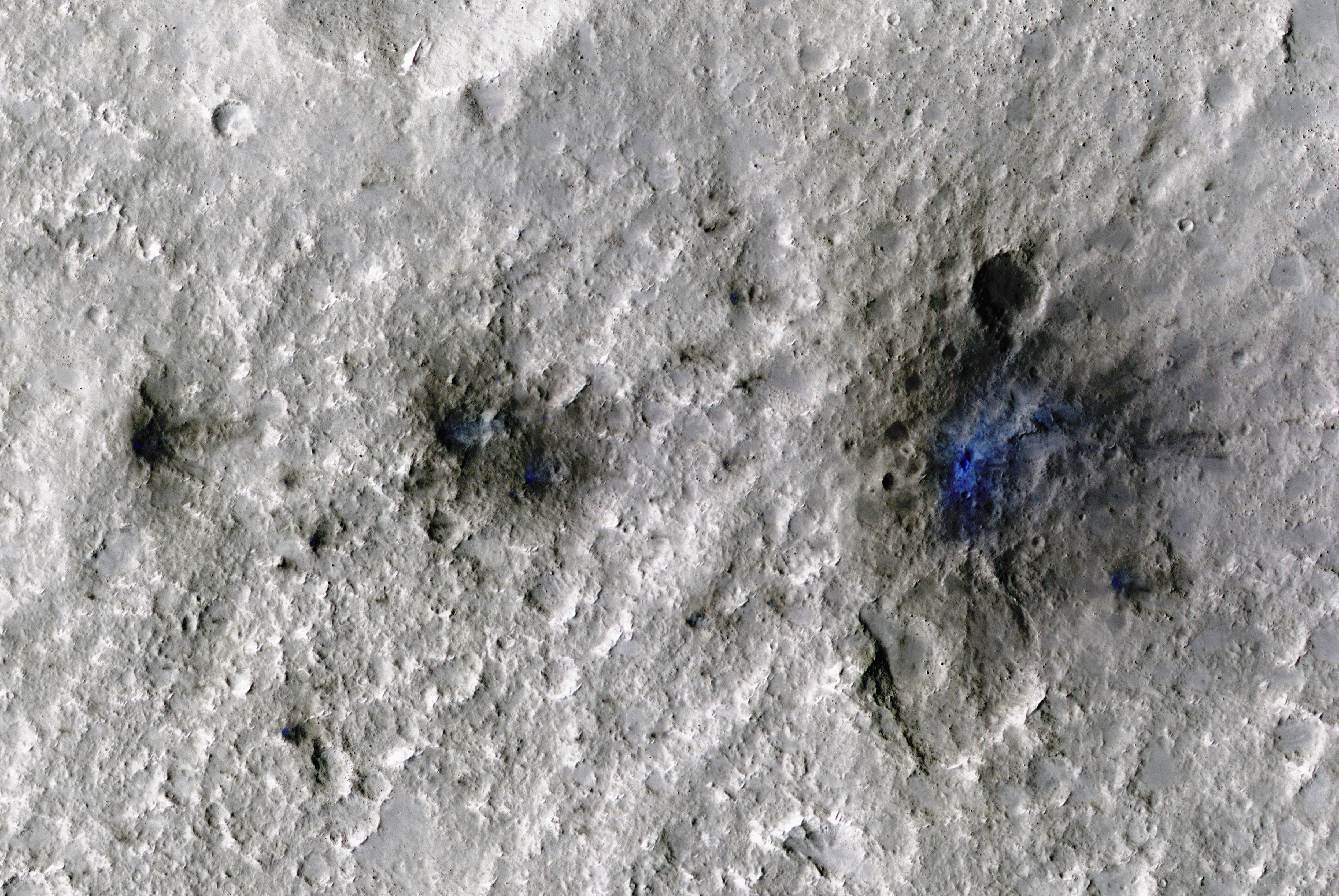
-
PIA25410:
-
InSight-Detected Impact in May 2020
Full Resolution:
TIFF
(25.26 MB)
JPEG
(1.547 MB)
|
|
|
2022-09-19 |
Mars
|
Mars Reconnaissance Orbiter (MRO)
|
HiRISE
|
4047x3466x3 |
|
-
PIA25409:
-
InSight-Detected Impact in February 2021
Full Resolution:
TIFF
(40.22 MB)
JPEG
(844.9 kB)
|
|
|
2022-09-19 |
Mars
|
Mars Reconnaissance Orbiter (MRO)
|
HiRISE
|
4994x3341x3 |
|
-
PIA25408:
-
InSight Detects an Impact for the First Time
Full Resolution:
TIFF
(50.08 MB)
JPEG
(2.9 MB)
|
|
|
2022-07-22 |
Earth
|
ECOSTRESS
|
|
3507x2480x3 |
|
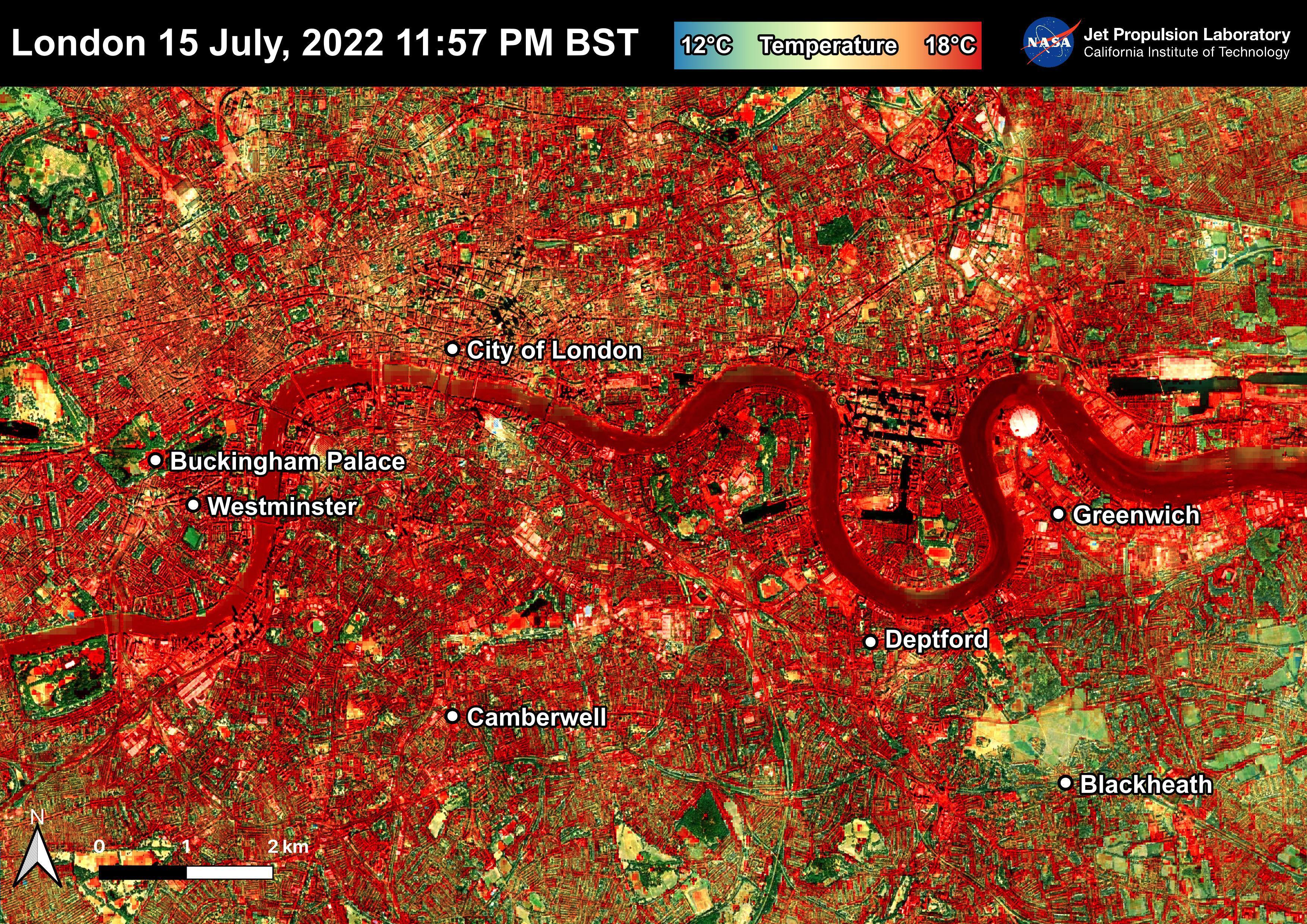
-
PIA25423:
-
NASA's ECOSTRESS Shows Overnight Heat in London
Full Resolution:
TIFF
(26.1 MB)
JPEG
(2.721 MB)
|
|
|
2022-06-22 |
Earth
|
ECOSTRESS
|
|
3099x2201x3 |
|
-
PIA25422:
-
NASA's ECOSTRESS Shows Heat in Dallas and Fort Worth
Full Resolution:
TIFF
(20.47 MB)
JPEG
(2.22 MB)
|
|
|
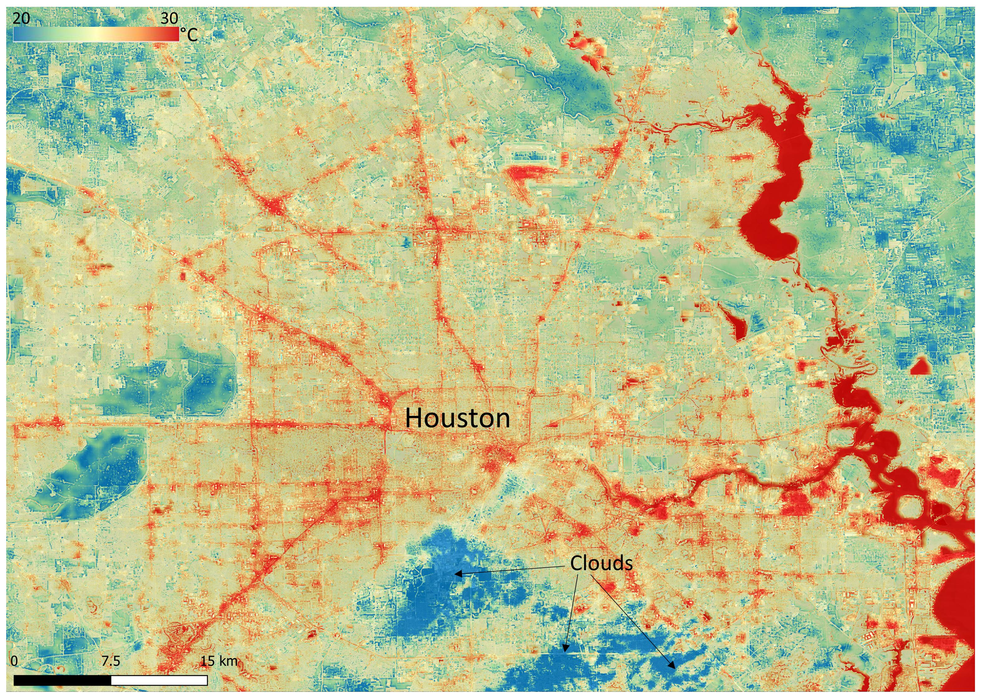
2022-06-22 |
Earth
|
ECOSTRESS
|
|
3161x2230x3 |
|
-
PIA25421:
-
NASA's ECOSTRESS Shows Surface Heat in Houston
Full Resolution:
TIFF
(21.16 MB)
JPEG
(1.711 MB)
|
|
|
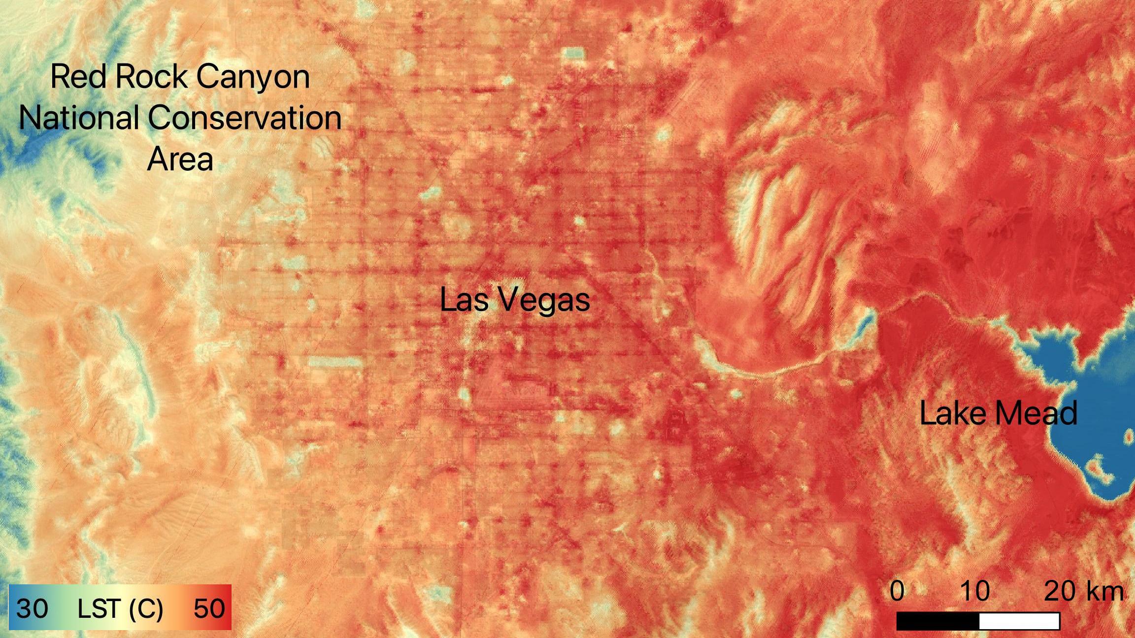
2022-06-15 |
Earth
|
ECOSTRESS
|
|
2304x1296x3 |

|
-
PIA24988:
-
NASA's ECOSTRESS Sees Las Vegas Streets Turn Up the Heat
Full Resolution:
TIFF
(8.962 MB)
JPEG
(479.4 kB)
|
|
|
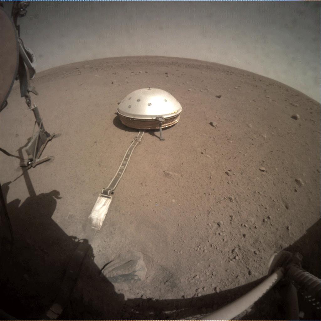
2022-05-23 |
Mars
|
InSight
|
|
4391x2635x3 |
|
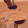
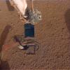
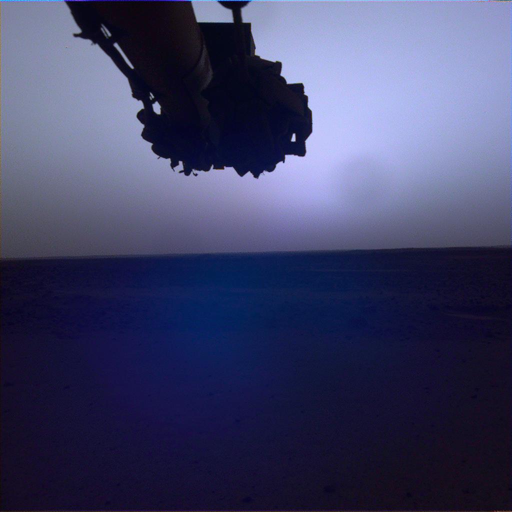
-
PIA25287:
-
InSight's Final Selfie
Full Resolution:
TIFF
(20.35 MB)
JPEG
(607.8 kB)
|
|
|
2022-05-17 |
Mars
|
InSight
|
|
1024x1024x3 |
|
-
PIA25286:
-
InSight's Dusty Solar Panel
Full Resolution:
TIFF
(3.147 MB)
JPEG
(143.3 kB)
|
|
|
2022-05-17 |
Mars
|
InSight
|
|
3840x2160x3 |
|
-
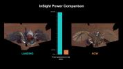
PIA25284:
-
InSight's Power Generation: After Landing and Spring 2022
Full Resolution:
TIFF
(6.892 MB)
JPEG
(436.2 kB)
|
|
|
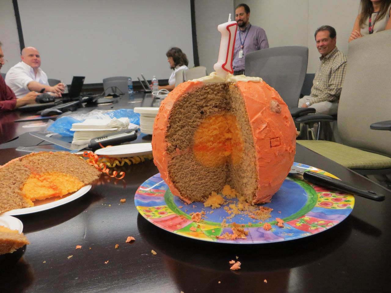
2022-05-17 |
|
InSight
|
|
1280x960x3 |
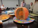
|
-
PIA25283:
-
InSight's Mars Birthday Cake
Full Resolution:
TIFF
(3.636 MB)
JPEG
(142.2 kB)
|
|
|
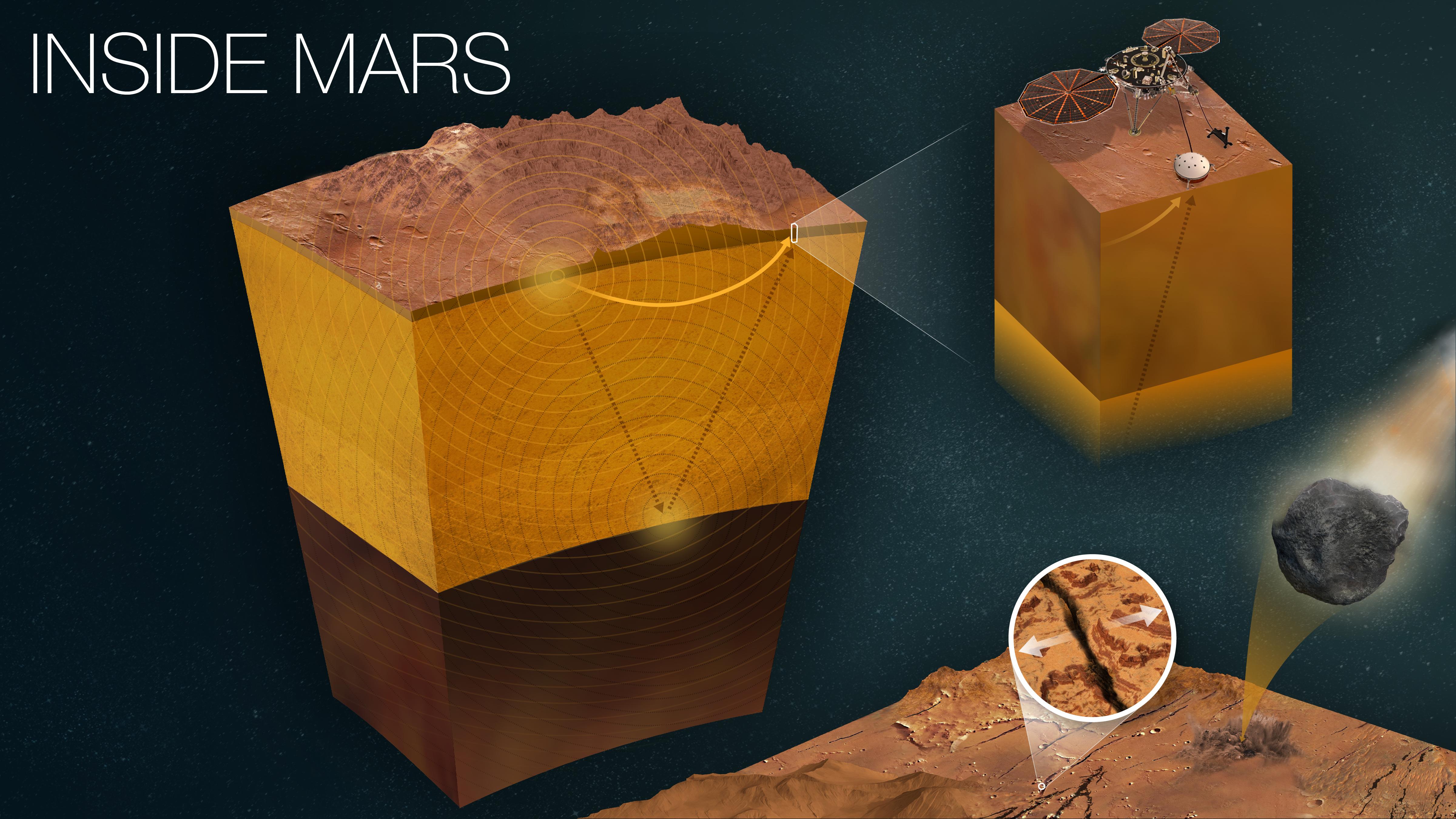
2022-05-17 |
Mars
|
InSight
|
|
4801x2700x3 |
|
-
PIA25282:
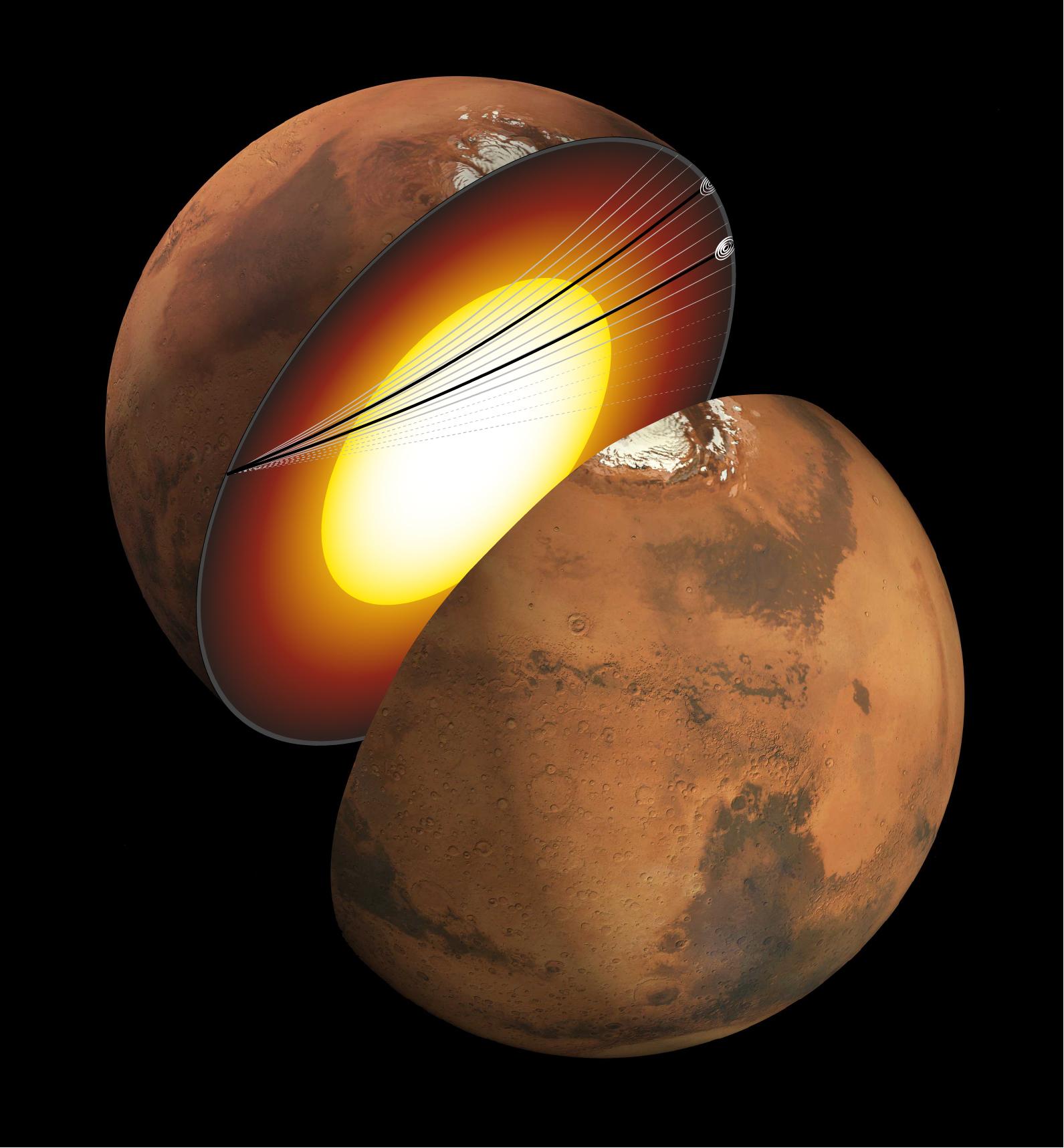
-
How InSight Studies Mars' Inner Layers
Full Resolution:
TIFF
(27.36 MB)
JPEG
(1.18 MB)
|
|
|
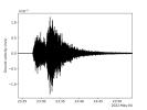
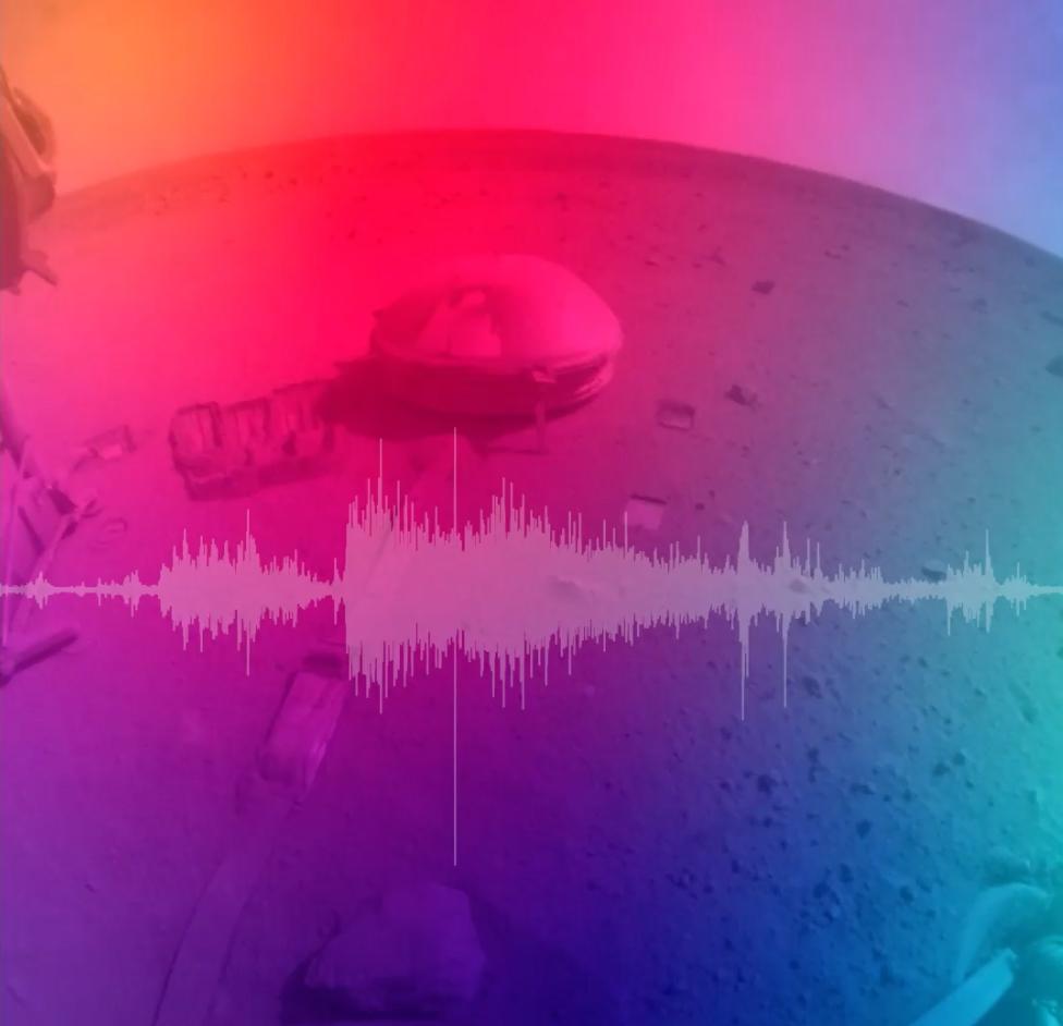
2022-05-17 |
Mars
|
InSight
|
|
1080x1080x3 |

|
-
PIA25281:
-
Seismogram and Sonification of InSight's Big Martian Quake
Full Resolution:
TIFF
(3.257 MB)
JPEG
(61.34 kB)
|
|
|
2022-05-12 |
Earth
|
ECOSTRESS
|
|
3376x2477x3 |
|
-
PIA24987:
-
ECOSTRESS Detects Heat Islands in Indian Heat Wave
Full Resolution:
TIFF
(25.1 MB)
JPEG
(2.193 MB)
|
|
|
2022-05-09 |
Mars
|
InSight
|
|
1920x1440x1 |
|
-
PIA25180:
-
InSight's Seismogram of Big Martian Quake
Full Resolution:
TIFF
(194.8 kB)
JPEG
(101.5 kB)
|
|
|
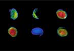
2022-05-09 |
Mars
|
InSight
|
|
1711x1007x3 |
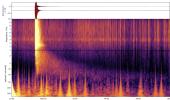
|
-
PIA25044:
-
InSight's Spectrogram of Big Martian Quake
Full Resolution:
TIFF
(4.615 MB)
JPEG
(237.2 kB)
|
|
|
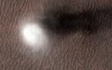
2022-04-27 |
Mars
|
Mars Helicopter
|
|
3099x2263x3 |
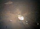
|
-
PIA25219:
-
Rover's Backshell Seen From the Air
Full Resolution:
TIFF
(20.68 MB)
JPEG
(1.009 MB)
|
|
|
2022-04-27 |
Mars
|
Mars Helicopter
|
|
3884x1161x3 |
|
-
PIA25218:
-
Debris Field for Perseverance Landing Gear Seen from Mars Helicopter
Full Resolution:
TIFF
(13.31 MB)
JPEG
(709.4 kB)
|
|
|
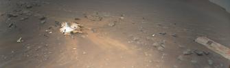
2022-04-27 |
Mars
|
Mars Helicopter
|
|
2322x2165x3 |
|
-
PIA25217:
-
Rover Landing Gear Seen From the Air by Mars Helicopter
Full Resolution:
TIFF
(15.09 MB)
JPEG
(837.6 kB)
|
|
|
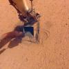
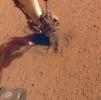
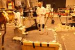
2022-04-15 |
Mars
|
InSight
|
|
1024x1024x3 |
|
-
PIA25178:
-
InSight Captures a Martian Sunrise and Sunset
Full Resolution:
TIFF
(2.742 MB)
JPEG
(79.33 kB)
|
|
|
2022-01-21 |
Mars
|
Mars Reconnaissance Orbiter (MRO)
|
HiRISE
|
2880x1800x3 |
|
-
PIA25090:
-
A Greenwich Observatory on Mars
Full Resolution:
TIFF
(15.56 MB)
JPEG
(812.2 kB)
|
|
|
2021-10-20 |
Mars
|
2001 Mars Odyssey
|
|
3600x2000x3 |
|
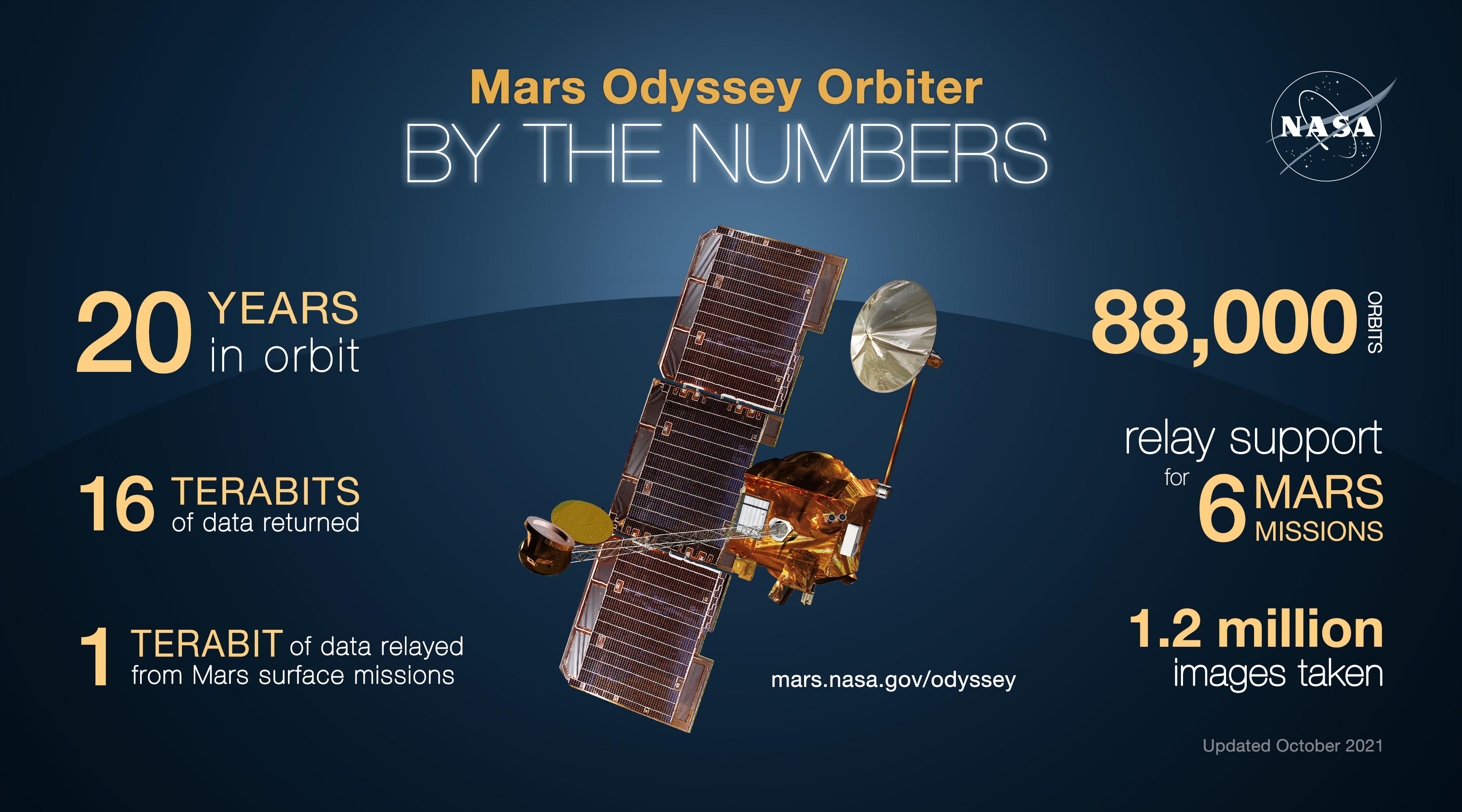
-
PIA24915:
-
Mars Odyssey Orbiter By the Numbers
Full Resolution:
TIFF
(9.303 MB)
JPEG
(529.5 kB)
|
|
|
2021-09-28 |
Mars
|
|
|
1600x900x3 |
|
-
PIA24838:
-
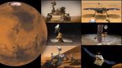
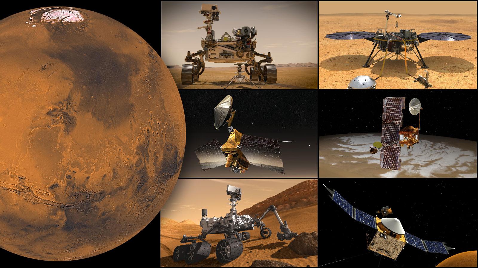
NASA's Mars Missions
Full Resolution:
TIFF
(3.67 MB)
JPEG
(236.6 kB)
|
|
|
2021-07-22 |
Mars
|
InSight
|
|
2687x831x3 |
|
-
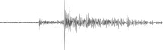
PIA24761:
-
Seismogram From Mars
Full Resolution:
TIFF
(275.9 kB)
JPEG
(92.9 kB)
|
|
|
2021-06-03 |
Mars
|
InSight
|
Heat and Physical Properties Package (HP3)
|
1024x1024x3 |
|
-
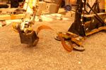
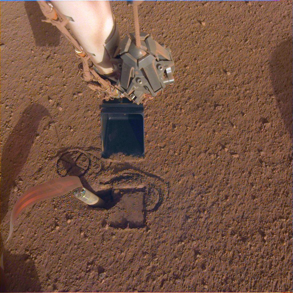
PIA24664:
-
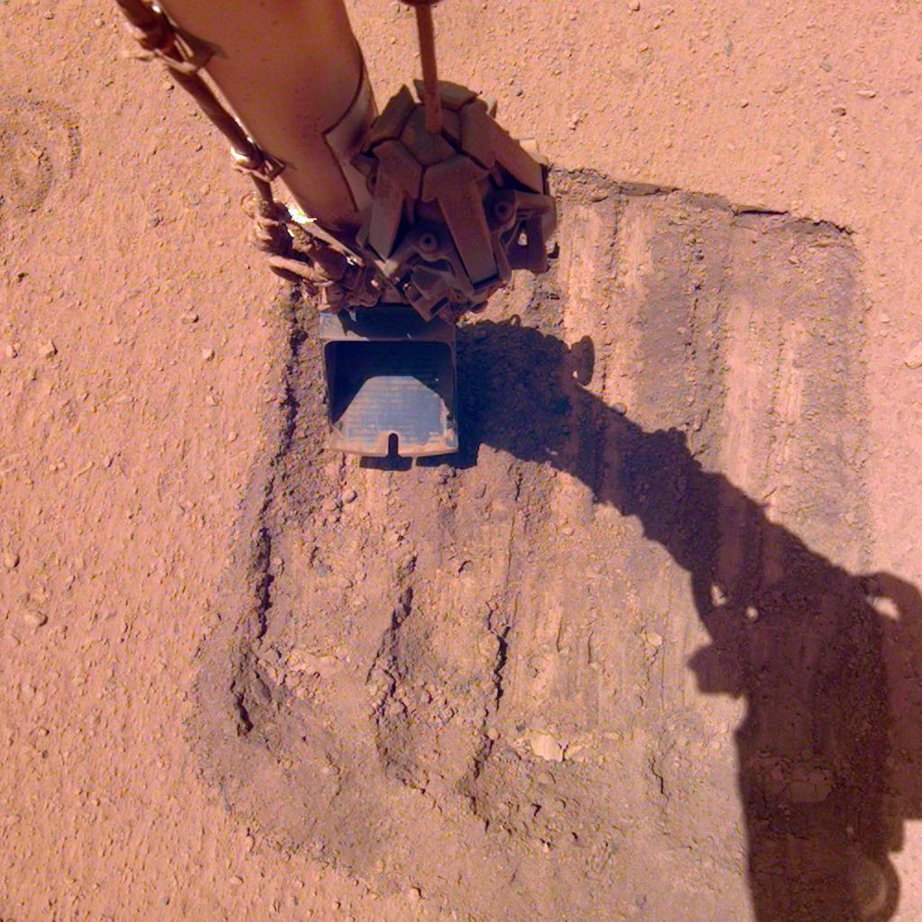
InSight's Robotic Arm Helps Remove Solar Panel Dust Trickles Sand in the Wind
Full Resolution:
TIFF
(3.147 MB)
JPEG
(194.1 kB)
|
|
|
2021-04-05 |
Asteroid
|
|
Deep Space Network
|
1254x958x1 |
|
-
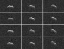
PIA24561:
-
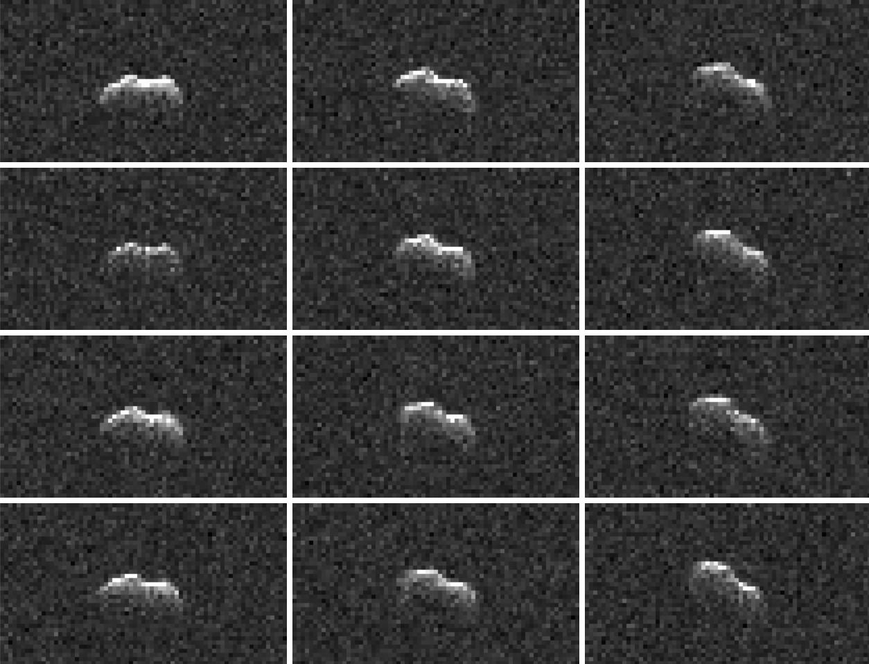
Goldstone Radar Observations of Asteroid 2001 FO32
Full Resolution:
TIFF
(916.4 kB)
JPEG
(154.5 kB)
|
|
|
2021-04-01 |
|
Europa Clipper
|
Europa Imaging System - Wide Angle
|
4608x3456x3 |

|
-
PIA24329:
-
Europa Imaging System Wide Angle Camera
Full Resolution:
TIFF
(36.57 MB)
JPEG
(1.413 MB)
|
|
|
2021-04-01 |
|
Europa Clipper
|
Europa Imaging System - Narrow Angle
|
3228x4236x3 |
|
-
PIA24328:
-
Europa Imaging System Narrow Angle Camera
Full Resolution:
TIFF
(41.04 MB)
JPEG
(2.058 MB)
|
|
|
2021-04-01 |
|
Europa Clipper
|
Europa Imaging System - Wide Angle
|
4608x3456x3 |
|
-
PIA24325:
-
Europa Clipper's Europa Imaging System in the Works
Full Resolution:
TIFF
(37.86 MB)
JPEG
(1.712 MB)
|
|
|
2021-04-01 |
Mars
|
InSight
|
Heat and Physical Properties Package (HP3)
|
1024x1018x3 |
|
-
PIA24450:
-
InSight Starts Burying Seismometer's Cable
Full Resolution:
TIFF
(2.22 MB)
JPEG
(140.4 kB)
|
|
|
2021-03-29 |
|
Psyche
|
|
4176x2784x3 |
|
-
PIA24476:
-
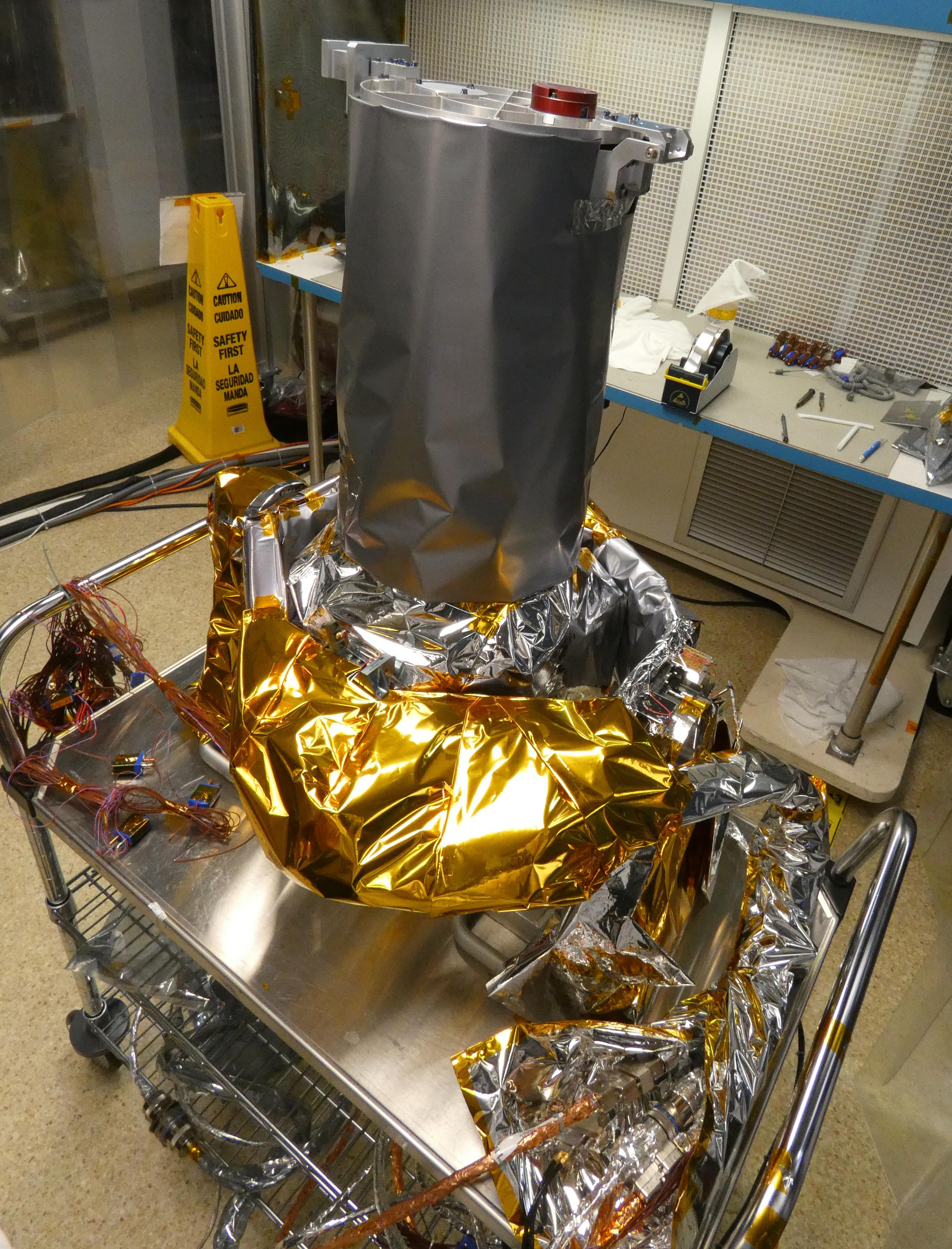
Chassis of NASA's Psyche Spacecraft Docks Safely
Full Resolution:
TIFF
(27.41 MB)
JPEG
(970.9 kB)
|
|
|
2021-03-29 |
|
Psyche
|
|
4176x2784x3 |
|
-
PIA24475:
-
NASA's Psyche Spacecraft Chassis Welcomed Into JPL's High Bay 1
Full Resolution:
TIFF
(24.83 MB)
JPEG
(1.067 MB)
|
|
|
2021-03-29 |
|
Psyche
|
|
4176x2784x3 |
|
-
PIA24474:
-
NASA's Psyche Spacecraft Chassis Arrives at the Agency's JPL
Full Resolution:
TIFF
(23.6 MB)
JPEG
(998.3 kB)
|
|
|
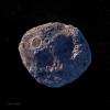
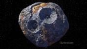
2021-03-29 |
Asteroid
|
Psyche
|
|
10800x10800x3 |
|
-
PIA24472:
-
Asteroid Psyche (Illustration)
Full Resolution:
TIFF
(134.6 MB)
JPEG
(8.453 MB)
|
|
|
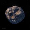
2021-03-29 |
Asteroid
|
Psyche
|
|
10800x10800x3 |
|
-
PIA24471:
-
Asteroid Psyche (Illustration)
Full Resolution:
TIFF
(133.9 MB)
JPEG
(8.736 MB)
|
|
|
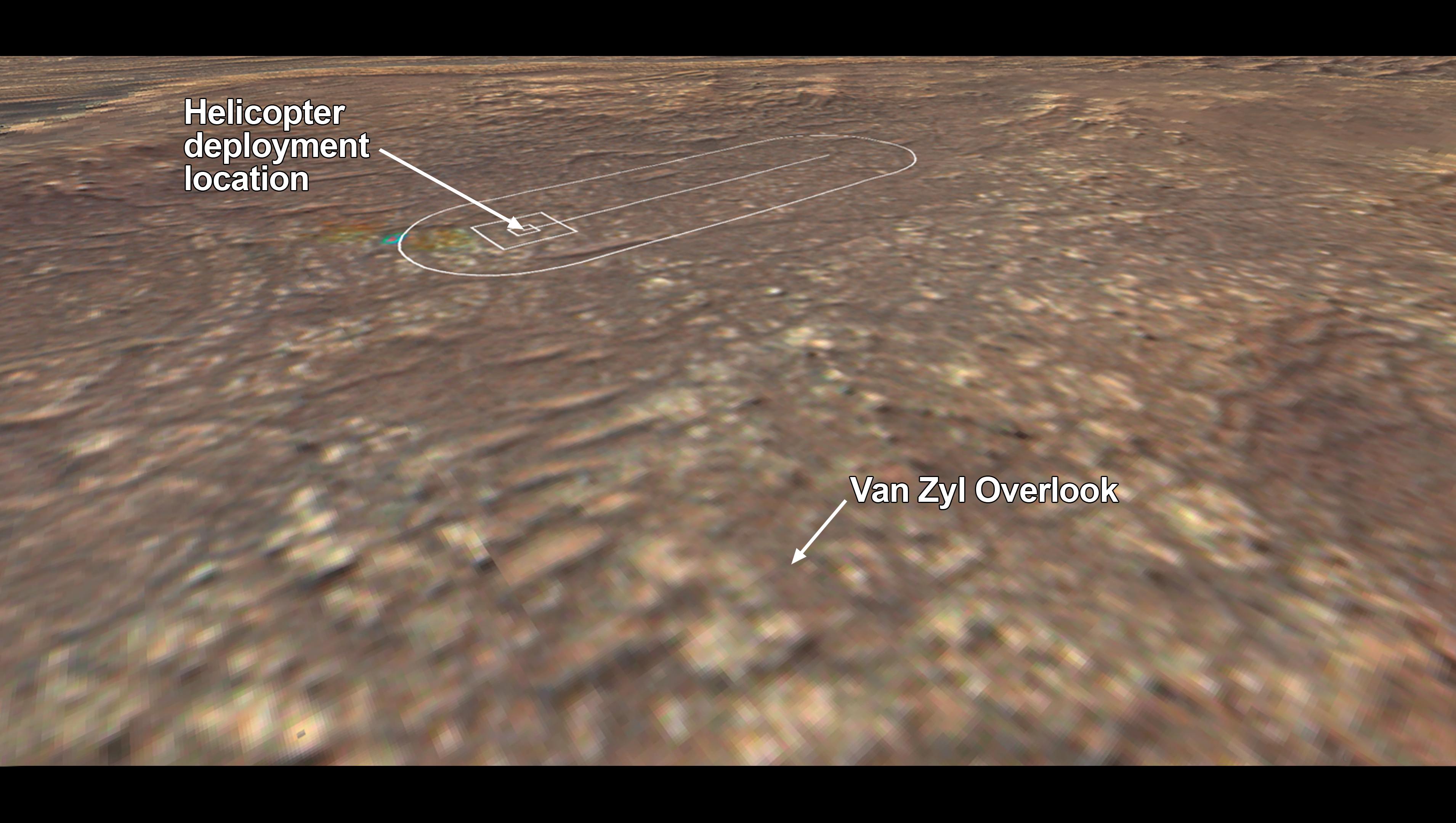
2021-03-23 |
Mars
|
Mars 2020 Rover
|
|
3820x2160x3 |
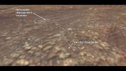
|
-
PIA24435:
-
Van Zyl Overlook
Full Resolution:
TIFF
(18.78 MB)
JPEG
(540.9 kB)
|
|
|
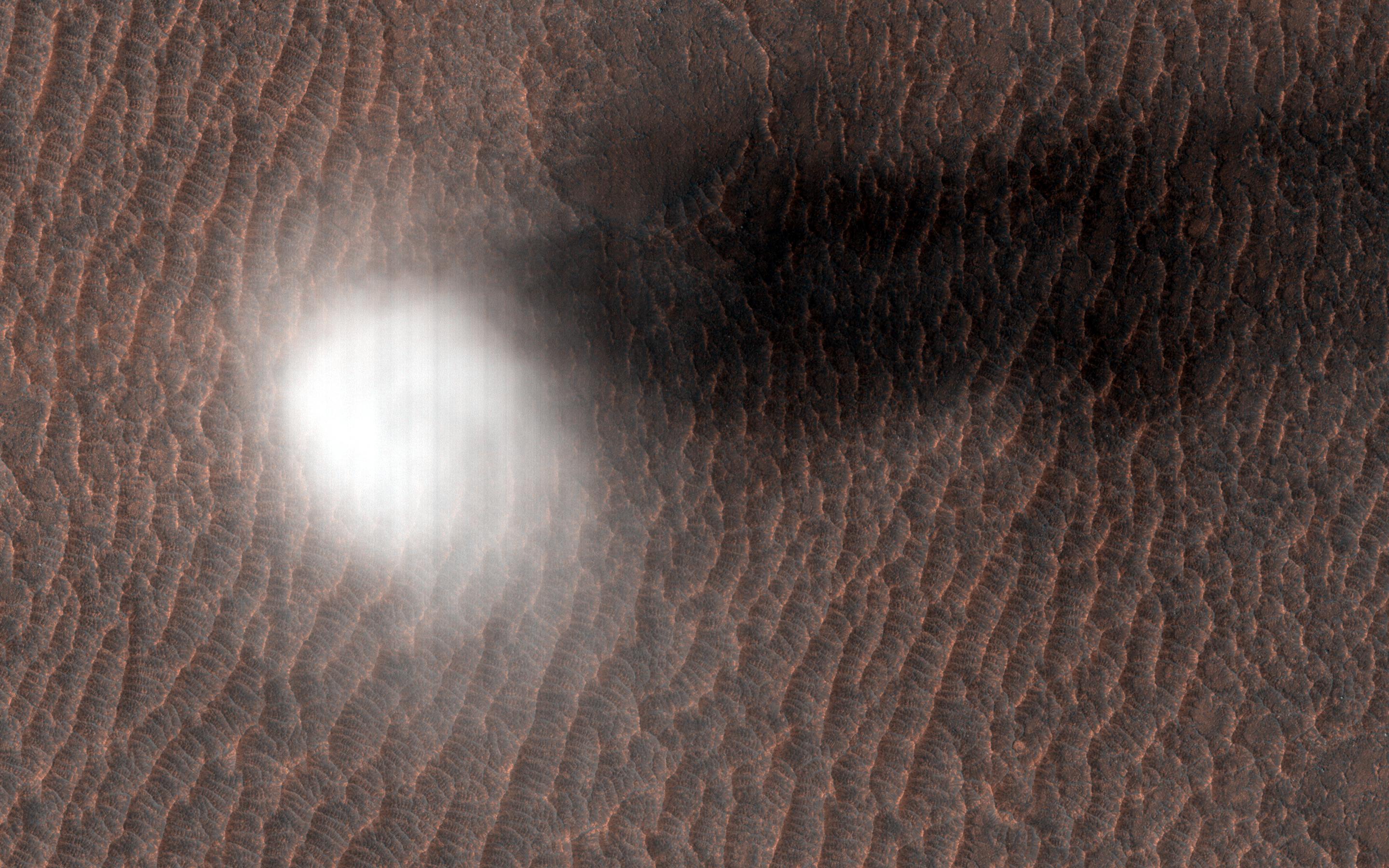
2021-02-26 |
Mars
|
Mars Reconnaissance Orbiter (MRO)
|
HiRISE
|
2880x1800x3 |
|
-
PIA24465:
-
A Dust Devil is Born
Full Resolution:
TIFF
(15.56 MB)
JPEG
(807 kB)
|
|
|
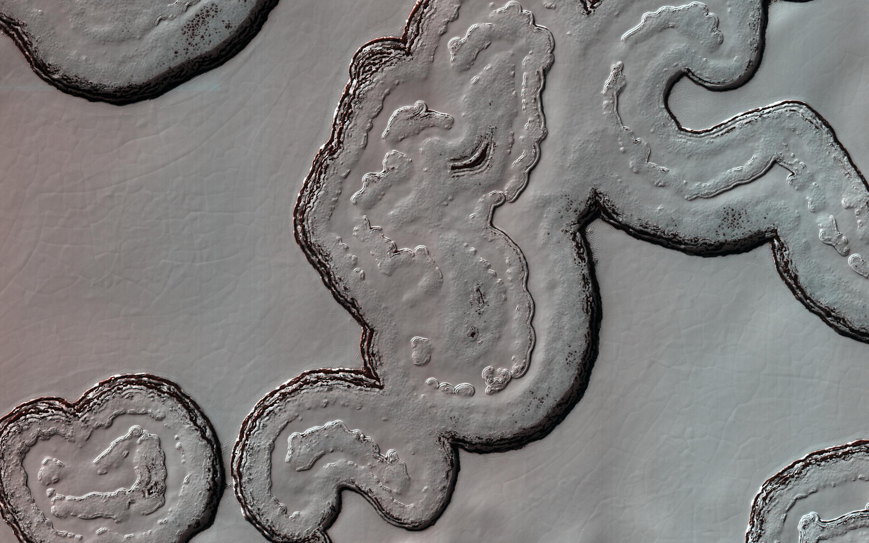
2021-02-26 |
Mars
|
Mars Reconnaissance Orbiter (MRO)
|
HiRISE
|
2880x1800x3 |
|
-
PIA24463:
-
South Polar Cap Terrain
Full Resolution:
TIFF
(13.67 MB)
JPEG
(626.3 kB)
|
|
|
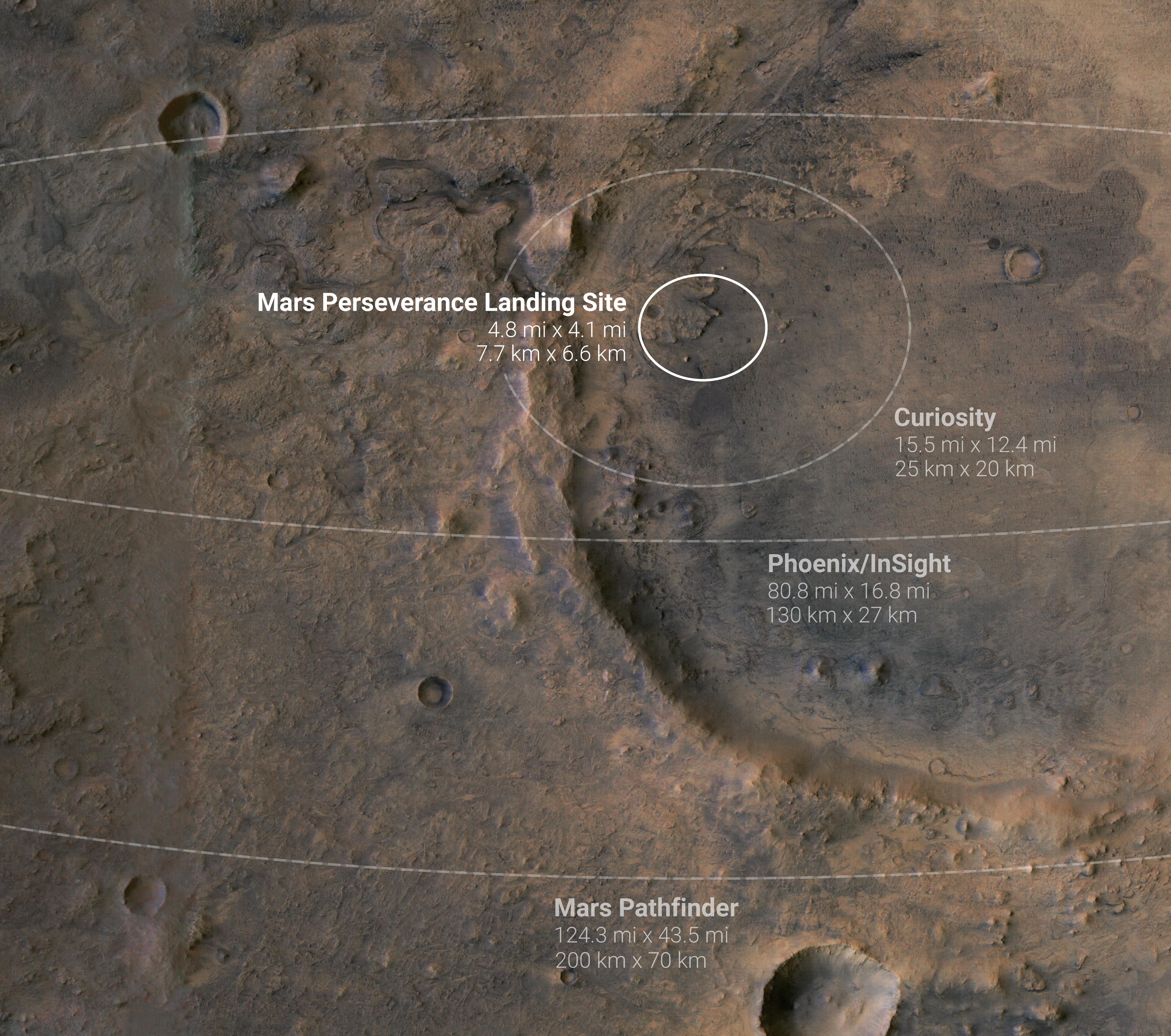
2021-01-27 |
Mars
|
|
|
4029x3567x3 |
|
-
PIA24377:
-
Mars Probe Landing Ellipses
Full Resolution:
TIFF
(37.84 MB)
JPEG
(1.847 MB)
|
|
|
2021-01-14 |
Mars
|
InSight
|
Heat and Physical Properties Package (HP3)
|
1012x1012x3 |
|
-
PIA24263:
-
InSight's Mole Comes to Rest
Full Resolution:
TIFF
(2.821 MB)
JPEG
(211.8 kB)
|
|
|
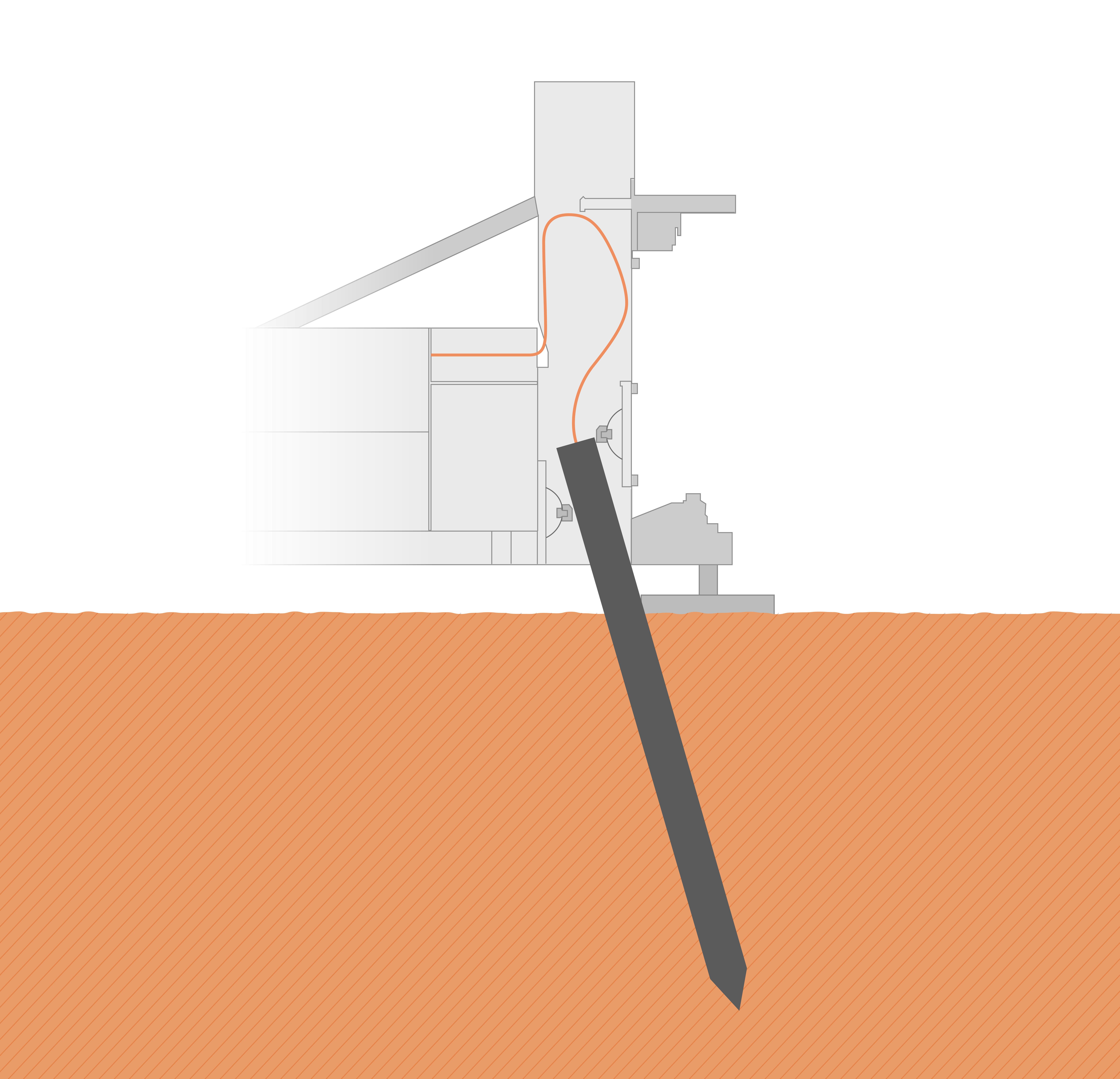
2021-01-08 |
|
Mars 2020 Rover
|
|
4029x3567x3 |
|
-
PIA24349:
-
Zeroing in on the Target
Full Resolution:
TIFF
(37.66 MB)
JPEG
(1.784 MB)
|
|
|
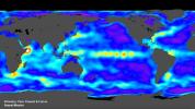
2020-10-28 |
Earth
|
ECOSTRESS
|
|
1695x1883x3 |

|
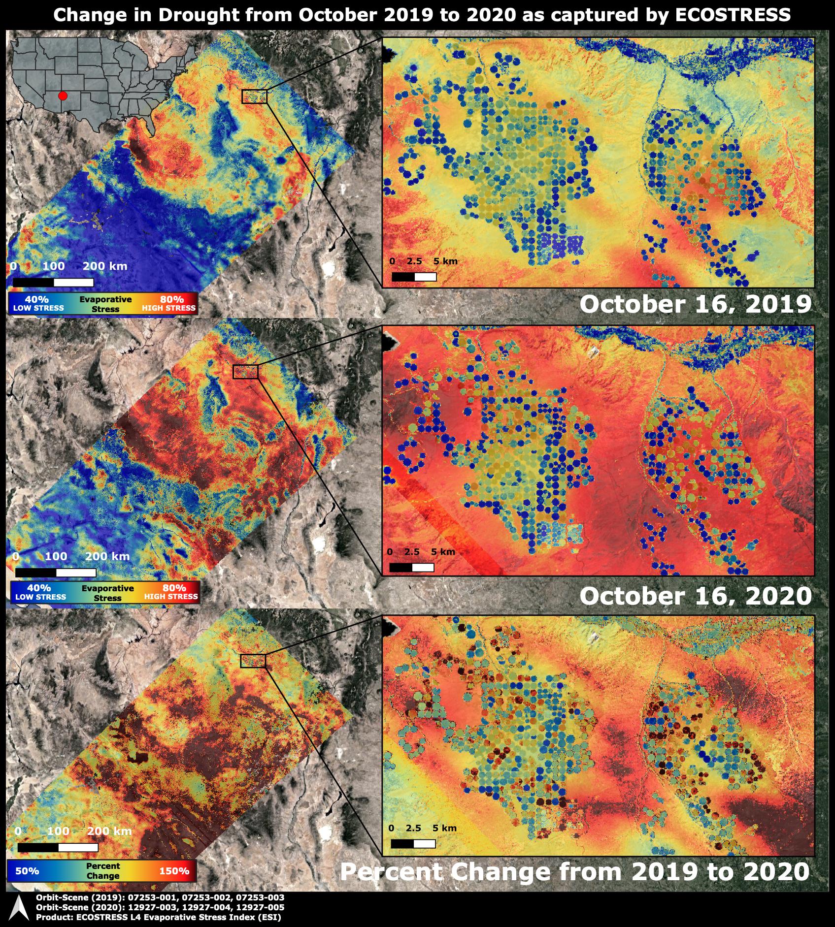
-
PIA24132:
-
ECOSTRESS Drought Stress Comparison
Full Resolution:
TIFF
(9.579 MB)
JPEG
(930 kB)
|
|
|
2020-10-16 |
Mars
|
InSight
|
Heat and Physical Properties Package (HP3)
|
1041x586x3 |
|
-
PIA24099:
-
Replica of InSight's Arm Practices Scraping
Full Resolution:
TIFF
(1.673 MB)
JPEG
(133.5 kB)
|
|
|
2020-10-16 |
Mars
|
InSight
|
Heat and Physical Properties Package (HP3)
|
1020x1012x3 |
|
-
PIA24098:
-
InSight's Arm Pulls Back, Revealing the Mole
Full Resolution:
TIFF
(2.936 MB)
JPEG
(235.9 kB)
|
|
|
2020-07-07 |
Asteroid
|
Psyche
|
|
1600x900x3 |
|
-
PIA23876:
-
A Metal-Rich World (Artist's Concept)
Full Resolution:
TIFF
(2.866 MB)
JPEG
(239.1 kB)
|
|
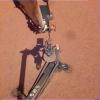
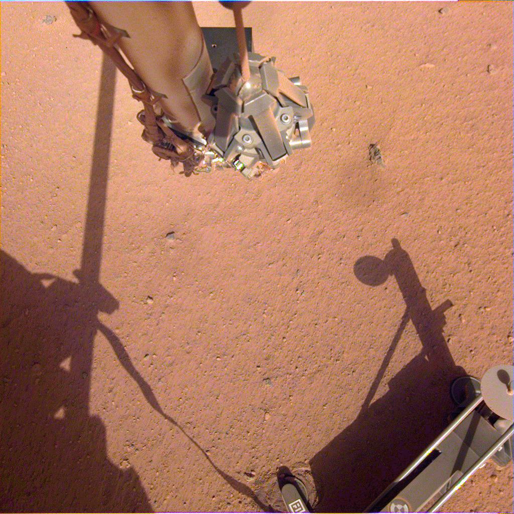
|
2020-07-07 |
Mars
|
InSight
|
Heat and Physical Properties Package (HP3)
|
1024x1016x3 |
|
-
PIA23896:
-
NASA InSight's Mole Taps the Bottom of the Lander's Scoop
Full Resolution:
TIFF
(2.857 MB)
JPEG
(228.6 kB)
|
|
|
2020-06-17 |
|
Mars 2020 Project
|
|
8208x5472x3 |

|
-
PIA23922:
-
Rocket to Mars (Artist's Concept)
Full Resolution:
TIFF
(118.7 MB)
JPEG
(4.427 MB)
|
|
|
2020-06-08 |
Phobos
|
2001 Mars Odyssey
|
THEMIS
|
6729x4602x3 |
|
-
PIA23893:
-
Odyssey's Six Views of Phobos
Full Resolution:
TIFF
(11.55 MB)
JPEG
(656.6 kB)
|
|
|
2020-02-21 |
Mars
|
InSight
|
Heat and Physical Properties Package (HP3)
|
1024x1024x3 |
|
-
PIA23622:
-
InSight Prepares to Push on the Mole
Full Resolution:
TIFF
(2.871 MB)
JPEG
(233.8 kB)
|
|
|
2020-02-21 |
Mars
|
InSight
|
Heat and Physical Properties Package (HP3)
|
6000x4000x3 |
|
-
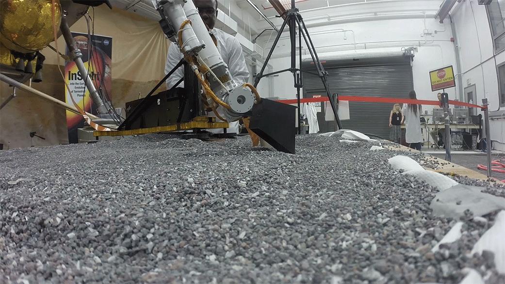
PIA23619:
-
Robotic Arm Pushes on a Model of the Mole
Full Resolution:
TIFF
(72.03 MB)
JPEG
(2.805 MB)
|
|
|
2019-11-06 |
Mars
|
InSight
|
Heat and Physical Properties Package (HP3)
|
1024x1024x3 |
|
-
PIA23512:
-
InSight's Arm Camera Stares Into the Pit
Full Resolution:
TIFF
(2.879 MB)
JPEG
(199.8 kB)
|
|
|
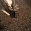
2019-10-28 |
Mars
|
InSight
|
|
1024x1024x3 |
|
-
PIA23213:
-
InSight's Heat Probe Partially Backs Out of Hole
Full Resolution:
TIFF
(3.147 MB)
JPEG
(207.9 kB)
|
|
|
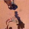
2019-10-17 |
Mars
|
InSight
|
|
1008x960x3 |
|
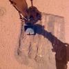
-
PIA23379:
-
Pinning Helps the Mole Move
Full Resolution:
TIFF
(2.566 MB)
JPEG
(125.9 kB)
|
|
|
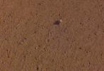
2019-10-16 |
Mars
|
Mars Reconnaissance Orbiter (MRO)
|
HiRISE
|
1600x899x3 |
|
-
PIA23376:
-
The Best View of InSight
Full Resolution:
TIFF
(3.819 MB)
JPEG
(177.6 kB)
|
|
|
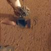
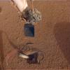
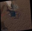
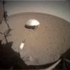
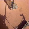
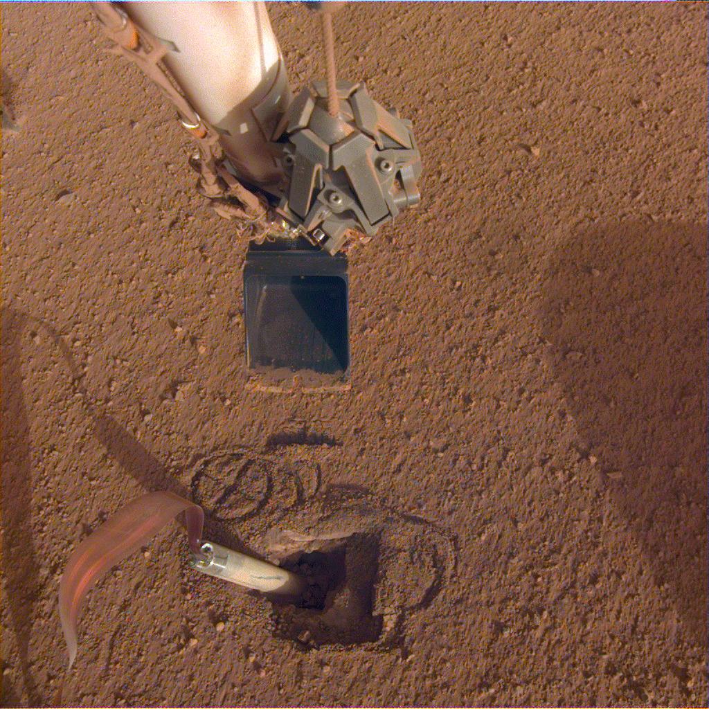
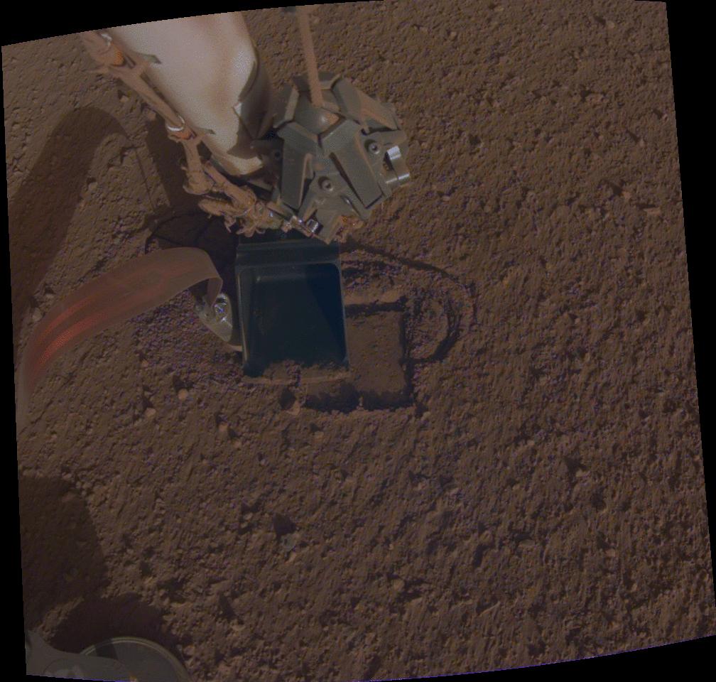
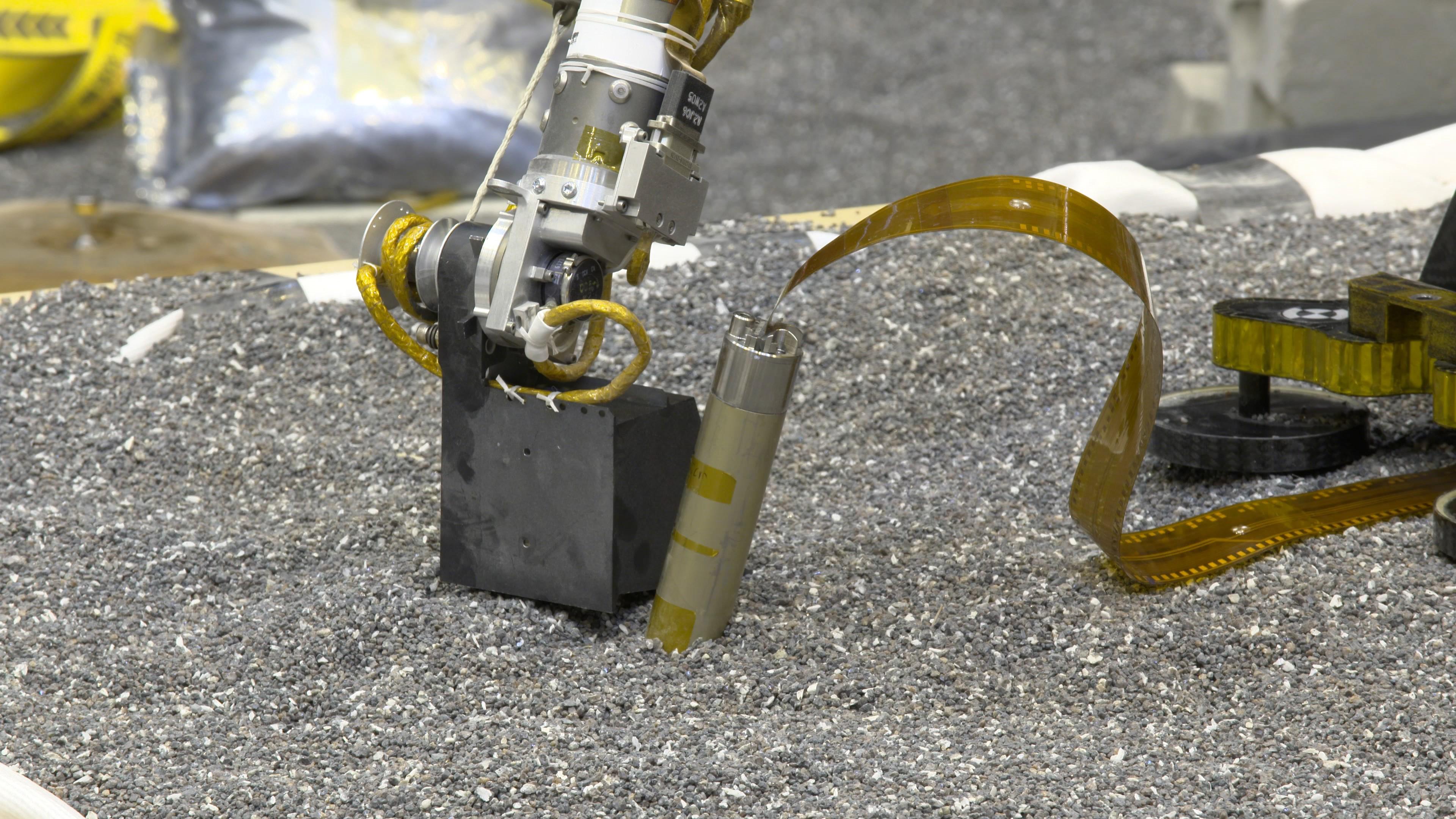
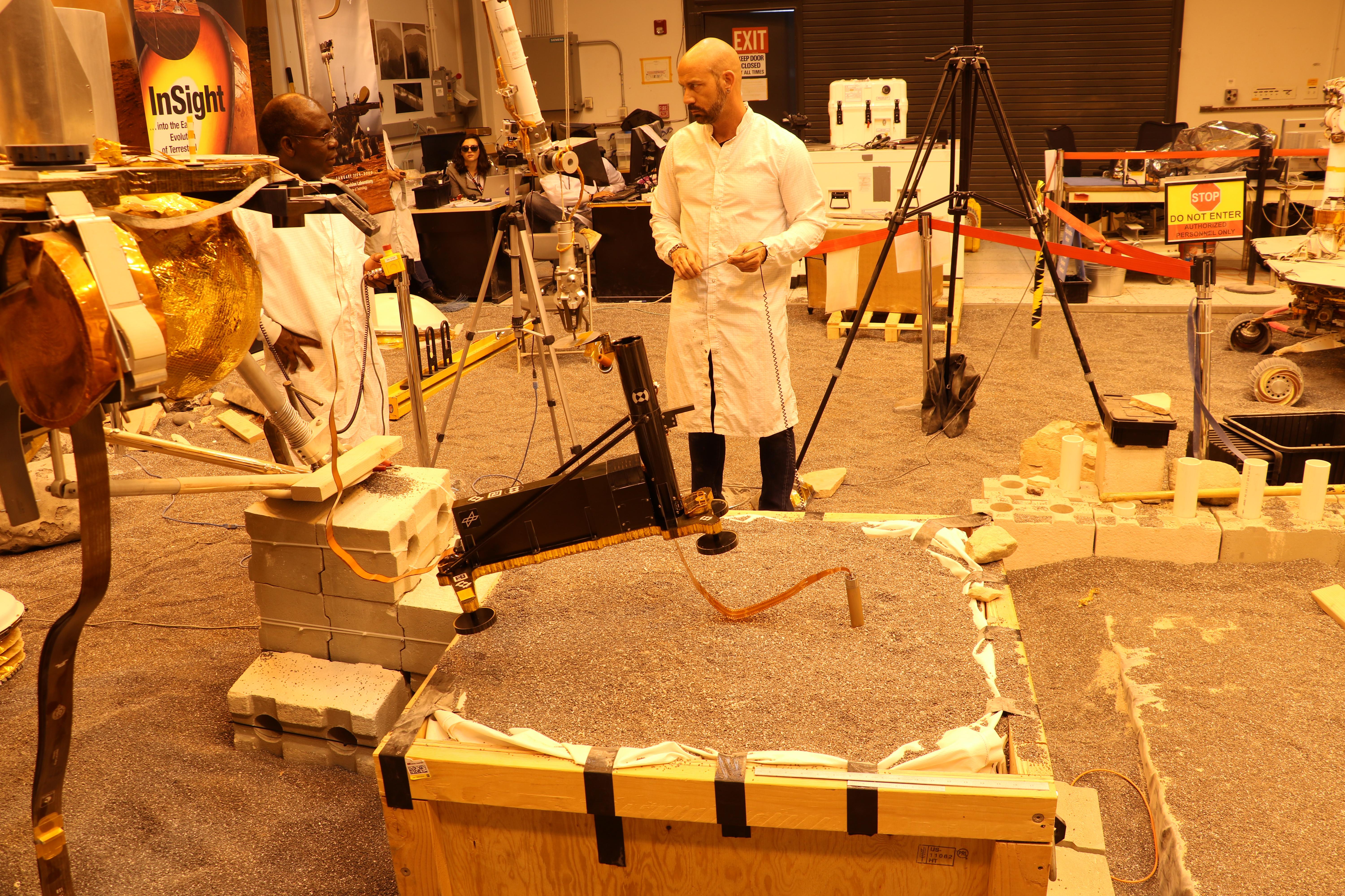
2019-10-03 |
Mars
|
InSight
|
Heat and Physical Properties Package (HP3)
|
1024x1024x3 |
|
-
PIA23373:
-
Preparing to Pin the Mole
Full Resolution:
TIFF
(2.858 MB)
JPEG
(238.3 kB)
|
|
|
2019-09-18 |
Mars
|
InSight
|
Instrument Context Camera (ICC)
|
1024x1024x3 |

|
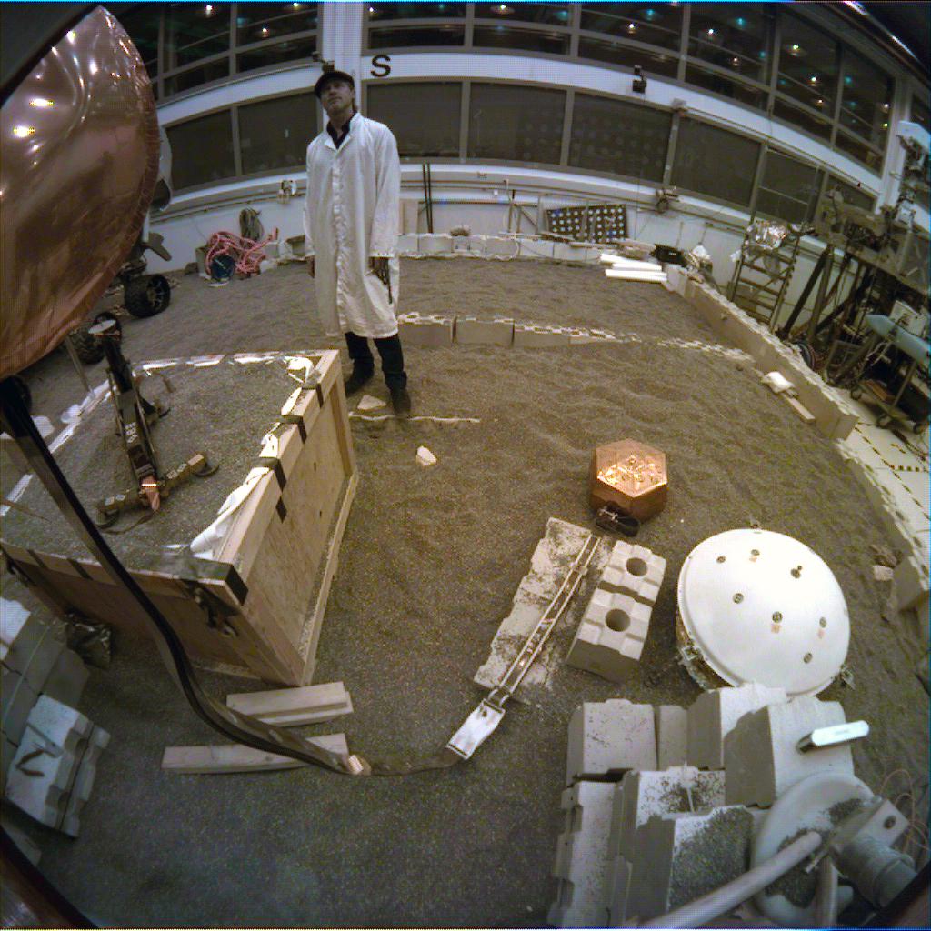
-
PIA23278:
-
A Hollywood Star in InSight's Mars 'Sandbox'
Full Resolution:
TIFF
(3.147 MB)
JPEG
(168.5 kB)
|
|
|
2019-09-18 |
Mars
|
InSight
|
Instrument Deployment Camera (IDC)
|
1024x1024x3 |

|
-
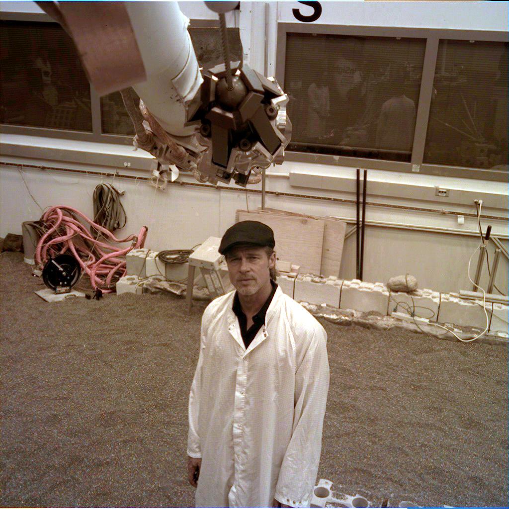
PIA23280:
-
InSight's Portrait of a Star (Brad Pitt)
Full Resolution:
TIFF
(3.147 MB)
JPEG
(180.6 kB)
|
|
|
2019-09-05 |
Mars
|
Mars Reconnaissance Orbiter (MRO)
|
HiRISE
|
2880x1800x3 |
|
-
PIA23454:
-
Layers in Danielson Crater
Full Resolution:
TIFF
(15.56 MB)
JPEG
(771.5 kB)
|
|
|
2019-08-23 |
Mars
|
InSight
|
Instrument Deployment Camera (IDC)
|
1400x788x3 |

|
-
PIA23345:
-
Rolling Stones Rock (Animation)
Full Resolution:
TIFF
(1.695 MB)
JPEG
(78.46 kB)
|
|
|
2019-08-23 |
Mars
|
InSight
|
Instrument Deployment Camera (IDC)
|
760x516x3 |
|
-
PIA23349:
-
Rolling Stones Rock
Full Resolution:
TIFF
(1.177 MB)
JPEG
(84.31 kB)
|
|
|
2019-07-01 |
Mars
|
InSight
|
Instrument Deployment Camera (IDC)
|
1024x1024x3 |
|
-
PIA23309:
-
Arm Camera: InSight Lifts the Mole's Support Structure
Full Resolution:
TIFF
(2.65 MB)
JPEG
(192.8 kB)
|
|
|
2019-07-01 |
Mars
|
InSight
|
Instrument Context Camera (ICC)
|
1024x1024x3 |
|
-
PIA23308:
-
Fisheye Camera: InSight Lifts the Mole's Support Structure
Full Resolution:
TIFF
(2.452 MB)
JPEG
(100.4 kB)
|
|
|
2019-06-05 |
Mars
|
InSight
|
Heat and Physical Properties Package (HP3)
|
1024x1024x3 |
|
-
PIA23277:
-
Getting Ready to Help InSight's Heat Probe
Full Resolution:
TIFF
(2.809 MB)
JPEG
(210.1 kB)
|
|
|
2019-06-05 |
Mars
|
InSight
|
Heat and Physical Properties Package (HP3)
|
3840x2160x3 |

|
-
PIA23276:
-
Testing How InSight's Arm Will Push on Mars
Full Resolution:
TIFF
(22.85 MB)
JPEG
(941.4 kB)
|
|
|
2019-06-05 |
Mars
|
InSight
|
Heat and Physical Properties Package (HP3)
|
7303x7031x3 |
|
-
PIA23274:
-
Current Position of InSight's Mole (Illustration)
Full Resolution:
TIFF
(16.7 MB)
JPEG
(1.522 MB)
|
|
|
2019-06-05 |
Mars
|
InSight
|
Heat and Physical Properties Package (HP3)
|
6000x4000x3 |
|
-
PIA23272:
-
JPL Engineers Test Heat Probe Strategies
Full Resolution:
TIFF
(72.03 MB)
JPEG
(3.492 MB)
|
 Planetary Data System


