PDS logoPlanetary Data System
PDS Information
Find a Node - Use these links to navigate to any of the 8 publicly accessible PDS Nodes.

This bar indicates that you are within the PDS enterprise which includes 6 science discipline nodes and 2 support nodes which are overseen by the Project Management Office at NASA's Goddard Space Flight Center (GSFC). Each node is led by an expert in the subject discipline, supported by an advisory group of other practitioners of that discipline, and subject to selection and approval under a regular NASA Research Announcement.
Click here to return to the Photojournal Home Page Click here to view a list of Photojournal Image Galleries Photojournal_inner_header
Latest Images  |  Spacecraft & Technology  |  Animations  |  Space Images App  |  Feedback  |  Photojournal Search  

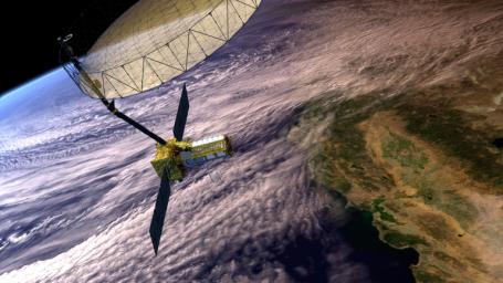
PIA26285: NISAR Satellite in Earth Orbit (Artist's Concept)
 Mission:  NISAR 
 Spacecraft:  NISAR
 Product Size:  3840 x 2160 pixels (w x h)
 Produced By:  JPL
 Full-Res TIFF:  PIA26285.tif (24.89 MB)
 Full-Res JPEG:  PIA26285.jpg (1.18 MB)

Click on the image above to download a moderately sized image in JPEG format (possibly reduced in size from original)

Original Caption Released with Image:

This artist's concept depicts the NISAR satellite in orbit over central and Northern California. Short for NASA-ISRO Synthetic Aperture Radar, NISAR is a joint mission of NASA and ISRO (Indian Space Research Organisation).

Scheduled to launch in 2024, NISAR features an advanced radar system to globally monitor changes to Earth's land and ice surfaces. The data it collects will deepen scientists' understanding of natural hazards, land use, climate change, and other global processes.

Housed within the satellite are two radar instruments: one from ISRO, and one built at NASA's Jet Propulsion Laboratory. The satellite also features an antenna reflector nearly 40 feet (12 meters) in diameter, supported by a deployable boom. Using this system, the satellite will bounce radar signals off nearly all the planet's solid surfaces twice every 12 days, tracking the motion of those surfaces down to fractions of an inch. The mission's measurements will also provide insights into other processes, including the dynamics of forests, wetlands, and agricultural lands.

NISAR is the first space-hardware collaboration between NASA and ISRO on an Earth-observing mission. JPL, which is managed for NASA by Caltech in Pasadena, California, leads the U.S. component of the project.

To learn more about NISAR, visit: https://nisar.jpl.nasa.gov/.

Image Credit:
NASA/JPL-Caltech

Image Addition Date:
2024-02-20