|
Your search criteria found 5575 images Mission |
| My List |
Addition Date | Target | Mission |
Instrument
|
Size |

|
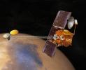
2002-12-21 |
2001 Mars Odyssey |
5824x4737x3 | ||
|
|||||
|
|
2002-12-21 |
2001 Mars Odyssey |
500x740x3 | ||
|
|||||
|
|
2002-12-21 |
2001 Mars Odyssey |
2201x2361x3 | ||
|
|||||
|
|
2003-01-28 | Mars |
2001 Mars Odyssey |
1196x3007x1 | |
|
|
|||||
|
|
2003-01-28 | Mars |
2001 Mars Odyssey |
1213x3061x1 | |
|
|
|||||
|
|
2003-10-28 | Mars |
2001 Mars Odyssey |
5417x4160x3 | |

|
|||||
|
|
2003-10-28 | Mars |
2001 Mars Odyssey |
6000x5000x3 | |
|
|||||
|
|
2003-10-28 | Mars |
2001 Mars Odyssey |
3760x3494x3 | |
|
|||||
|
|
2003-10-28 | Mars |
2001 Mars Odyssey |
4000x4000x3 | |

|
|||||
|
|
2004-02-09 | Mars |
2001 Mars Odyssey Mars Exploration Rover (MER) |
1000x750x3 | |
|
|||||
|
|
2004-10-06 | Mars |
2001 Mars Odyssey |
1382x3226x1 | |
|
|
|||||
|
|
2007-06-18 | Mars |
2001 Mars Odyssey |
1400x2983x1 | |
|
|
|||||
|
|
2007-06-19 | Mars |
2001 Mars Odyssey |
1047x2908x1 | |
|
|
|||||
|
|
2007-06-20 | Mars |
2001 Mars Odyssey |
1359x2976x1 | |
|
|
|||||
|
|
2007-06-21 | Mars |
2001 Mars Odyssey |
320x3600x1 | |
|
|
|||||
|
|
2007-06-22 | Mars |
2001 Mars Odyssey |
1129x3179x1 | |
|
|
|||||
|
|
2007-06-25 | Mars |
2001 Mars Odyssey |
1382x2974x1 | |
|
|
|||||
|
|
2007-06-26 | Mars |
2001 Mars Odyssey |
1357x2943x1 | |
|
|
|||||
|
|
2007-06-27 | Mars |
2001 Mars Odyssey |
1355x2934x1 | |
|
|
|||||
|
|
2007-06-28 | Mars |
2001 Mars Odyssey |
1364x2940x1 | |
|
|
|||||
|
|
2007-06-29 | Mars |
2001 Mars Odyssey |
1347x2948x1 | |
|
|
|||||
|
|
2010-04-01 | Mars |
2001 Mars Odyssey |
1328x2775x1 | |
|
|
|||||
|
|
2016-04-05 | Mars |
2001 Mars Odyssey |
2670x1752x3 | |
|
|||||
|
|
2021-10-20 | Mars |
2001 Mars Odyssey |
3600x2000x3 | |
|
|||||
|
|
2015-09-02 | Mars |
2001 Mars Odyssey Mars Reconnaissance Orbiter (MRO) |
CRISM THEMIS |
1234x616x3 |
|
|||||
|
|
2016-05-03 | Mars |
2001 Mars Odyssey Mars Reconnaissance Orbiter (MRO) |
CRISM THEMIS |
758x747x3 |
|
|||||
|
|
2004-02-09 | Mars |
2001 Mars Odyssey Mars Global Surveyor (MGS) Mars Exploration Rover (MER) |
Descent Image Motion Estimation System (DIMES) Mars Orbiter Camera (MOC) Thermal Emission Imaging System |
4000x5308x3 |
|
|||||
|
|
2005-03-30 | Mars |
Mars Exploration Rover (MER) Mars Global Surveyor (MGS) 2001 Mars Odyssey |
Descent Image Motion Estimation System (DIMES) Mars Orbiter Camera Thermal Emission Imaging System |
2392x1823x3 |
|
|||||
|
|
2005-12-05 | Mars |
Mars Global Surveyor (MGS) Mars Exploration Rover (MER) 2001 Mars Odyssey |
Descent Image Motion Estimation System (DIMES) Mars Orbiter Camera Thermal Emission Imaging System |
1415x2044x3 |
|
|||||
|
|
2005-12-05 | Mars |
2001 Mars Odyssey Mars Global Surveyor (MGS) Mars Exploration Rover (MER) |
Descent Image Motion Estimation System (DIMES) Mars Orbiter Camera Thermal Emission Imaging System |
1411x2043x3 |
|
|||||
|
|
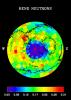
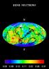
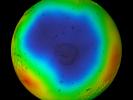
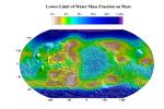
2011-08-04 | Mars |
2001 Mars Odyssey |
Gamma Ray Spectrometer - Neutron Spectrometer |
2536x1465x3 |
|
|||||
|
|
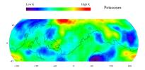
2002-03-01 | Mars |
2001 Mars Odyssey |
Gamma Ray Spectrometer Suite |
842x595x3 |

|
|||||
|
|
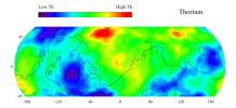
2002-03-01 | Mars |
2001 Mars Odyssey |
Gamma Ray Spectrometer Suite |
842x595x3 |
|
|||||
|
|
2002-03-01 | Mars |
2001 Mars Odyssey |
Gamma Ray Spectrometer Suite |
793x1123x3 |
|
|||||
|
|
2002-03-06 | Mars |
2001 Mars Odyssey |
Gamma Ray Spectrometer Suite |
793x1123x3 |
|
|||||
|
|
2002-05-28 | Mars |
2001 Mars Odyssey |
Gamma Ray Spectrometer Suite |
2668x1371x3 |
|
|||||
|
|
2002-05-28 | Mars |
2001 Mars Odyssey |
Gamma Ray Spectrometer Suite |
2668x1371x3 |
|
|||||
|
|
2002-05-28 | Mars |
2001 Mars Odyssey |
Gamma Ray Spectrometer Suite |
1640x1750x3 |
|
|||||
|
|
2002-05-28 | Mars |
2001 Mars Odyssey |
Gamma Ray Spectrometer Suite |
1764x1068x3 |
|
|||||
|
|
2002-05-28 | Mars |
2001 Mars Odyssey |
Gamma Ray Spectrometer Suite |
5300x6450x3 |
|
|||||
|
|
2002-05-30 | Mars |
2001 Mars Odyssey |
Gamma Ray Spectrometer Suite |
1785x2532x3 |
|
|||||
|
|
2002-05-30 | Mars |
2001 Mars Odyssey |
Gamma Ray Spectrometer Suite |
1785x2532x3 |
|
|||||
|
|
2002-12-10 | Mars |
2001 Mars Odyssey |
Gamma Ray Spectrometer Suite |
663x1024x3 |
|
|||||
|
|
2003-03-13 | Mars |
2001 Mars Odyssey |
Gamma Ray Spectrometer Suite |
2068x1009x3 |
|
|||||
|
|
2003-03-13 | Mars |
2001 Mars Odyssey |
Gamma Ray Spectrometer Suite |
1163x1579x3 |
|
|||||
|
|
2003-03-13 | Mars |
2001 Mars Odyssey |
Gamma Ray Spectrometer Suite |
2072x1013x3 |
|
|||||
|
|
2003-03-13 | Mars |
2001 Mars Odyssey |
Gamma Ray Spectrometer Suite |
2065x929x3 |

|
|||||
|
|
2003-03-13 | Mars |
2001 Mars Odyssey |
Gamma Ray Spectrometer Suite |
2068x947x3 |
|
|||||
|
|
2003-06-30 | Mars |
2001 Mars Odyssey |
Gamma Ray Spectrometer Suite |
2560x1918x3 |
|
|||||
|
|
2003-06-30 | Mars |
2001 Mars Odyssey |
Gamma Ray Spectrometer Suite |
2560x1918x3 |

|
|||||
|
|
2003-06-30 | Mars |
2001 Mars Odyssey |
Gamma Ray Spectrometer Suite |
2560x1918x3 |

|
|||||
|
|
2003-12-08 | Mars |
2001 Mars Odyssey |
Gamma Ray Spectrometer Suite |
1134x756x3 |
|
|||||
|
|
2003-12-08 | Mars |
2001 Mars Odyssey |
Gamma Ray Spectrometer Suite |
1850x2272x3 |
|
|||||
|
|
2008-11-18 | Mars |
2001 Mars Odyssey |
Gamma Ray Spectrometer Laser Altimeter |
850x650x3 |
|
|||||
|
|
2013-06-11 | Mars |
2001 Mars Odyssey Mars Reconnaissance Orbiter (MRO) Mars Global Surveyor (MGS) |
HiRISE Mars Orbiter Camera (MOC) THEMIS |
960x608x3 |
|
|||||
|
|
2019-12-10 | Mars |
2001 Mars Odyssey Mars Reconnaissance Orbiter (MRO) Mars Global Surveyor (MGS) |
MCS THEMIS |
1614x720x3 |
|
|||||
|
|
2005-05-19 |
2001 Mars Odyssey Mars Global Surveyor (MGS) |
Mars Orbiter Camera (MOC) |
627x393x1 | |

|
|||||
|
|
2005-05-19 |
2001 Mars Odyssey Mars Global Surveyor (MGS) |
Mars Orbiter Camera (MOC) |
350x350x3 | |
|
|||||
|
|
2005-05-19 |
2001 Mars Odyssey Mars Global Surveyor (MGS) |
Mars Orbiter Camera (MOC) |
488x513x1 | |

|
|||||
|
|
2004-01-13 | Mars |
2001 Mars Odyssey Mars Global Surveyor (MGS) Mars Exploration Rover (MER) |
Mars Orbiter Camera (MOC) Thermal Emission Imaging System |
720x540x3 |
|
|||||
|
|
2004-01-13 | Mars |
2001 Mars Odyssey Mars Global Surveyor (MGS) Mars Exploration Rover (MER) |
Mars Orbiter Camera (MOC) Thermal Emission Imaging System |
720x540x3 |
|
|||||
|
|
2004-03-18 | Mars |
2001 Mars Odyssey Mars Global Surveyor (MGS) Mars Exploration Rover (MER) |
Mars Orbiter Camera (MOC) Thermal Emission Imaging System |
1051x681x3 |

|
|||||
|
|
2004-03-19 | Mars |
2001 Mars Odyssey Mars Global Surveyor (MGS) Mars Exploration Rover (MER) |
Mars Orbiter Camera (MOC) Thermal Emission Imaging System |
1920x1080x3 |
|
|||||
|
|
2004-04-28 | Mars |
2001 Mars Odyssey Mars Global Surveyor (MGS) Mars Exploration Rover (MER) |
Mars Orbiter Camera (MOC) Thermal Emission Imaging System |
647x485x3 |
|
|||||
|
|
2004-04-29 | Mars |
2001 Mars Odyssey Mars Global Surveyor (MGS) Mars Exploration Rover (MER) |
Mars Orbiter Camera (MOC) Thermal Emission Imaging System |
671x455x3 |

|
|||||
|
|
2003-12-18 | Mars |
2001 Mars Odyssey Mars Global Surveyor (MGS) |
Mars Orbiter Camera (MOC) Thermal Emission Imaging System Visual Imaging Subsystem |
2880x2880x3 |

|
|||||
|
|
2004-07-16 | Mars |
2001 Mars Odyssey Mars Global Surveyor (MGS) Mars Exploration Rover (MER) |
Mars Orbiter Camera (MOC) Thermal Emission Spectrometer |
1183x638x3 |
|
|||||
|
|
2001-03-27 | Mars |
2001 Mars Odyssey |
Mars Orbiter Camera (MOC) THEMIS |
1440x1080x3 |
|
|||||
|
|
2001-03-27 | Mars |
2001 Mars Odyssey |
Mars Orbiter Camera (MOC) THEMIS |
1440x1080x3 |
|
|||||
|
|
2001-03-27 | Mars |
2001 Mars Odyssey |
Mars Orbiter Camera (MOC) THEMIS |
1440x1080x3 |
|
|||||
|
|
2016-03-21 | Mars |
2001 Mars Odyssey Mars Global Surveyor (MGS) Mars Reconnaissance Orbiter (MRO) |
MOLA |
3200x1500x3 |
|
|||||
|
|
2016-03-21 | Mars |
2001 Mars Odyssey Mars Global Surveyor (MGS) Mars Reconnaissance Orbiter (MRO) |
MOLA |
2400x2400x3 |

|
|||||
|
|
2016-03-21 | Mars |
2001 Mars Odyssey Mars Global Surveyor (MGS) Mars Reconnaissance Orbiter (MRO) |
MOLA |
2400x2400x3 |
|
|||||
|
|
2003-06-17 | Mars |
2001 Mars Odyssey |
MOLA Thermal Emission Imaging System |
1239x3043x1 |
|
|
|||||
|
|
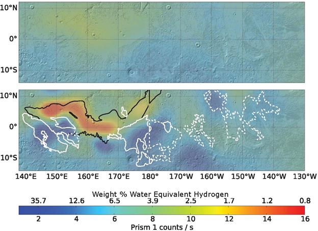
2011-03-08 | Mars |
2001 Mars Odyssey Mars Global Surveyor (MGS) |
MOLA THEMIS |
708x605x3 |
|
|||||
|
|
2011-07-06 | Mars |
2001 Mars Odyssey Mars Global Surveyor (MGS) Mars Science Laboratory (MSL) |
MOLA THEMIS |
1920x1080x3 |
|
|||||
|
|
2013-12-10 | Mars |
2001 Mars Odyssey Mars Global Surveyor (MGS) |
MOLA THEMIS |
960x665x3 |
|
|||||
|
|
2013-12-10 | Mars |
2001 Mars Odyssey Mars Global Surveyor (MGS) |
MOLA THEMIS |
989x481x3 |
|
|||||
|
|
2016-09-15 | Mars |
2001 Mars Odyssey Mars Global Surveyor (MGS) |
MOLA THEMIS |
1316x1840x3 |

|
|||||
|
|
2016-09-15 | Mars |
2001 Mars Odyssey Mars Global Surveyor (MGS) |
MOLA THEMIS |
1726x2453x3 |
|
|||||
|
|
2002-03-01 | Mars |
2001 Mars Odyssey |
Mars Radiation Experiment |
3000x2400x3 |
|
|||||
|
|
2002-03-01 | Mars |
2001 Mars Odyssey |
Mars Radiation Experiment |
3000x2400x3 |

|
|||||
|
|
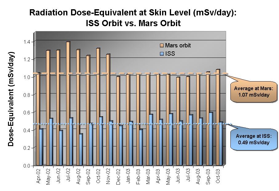
2002-12-07 | Mars |
2001 Mars Odyssey |
Mars Radiation Experiment |
907x621x3 |
|
|||||
|
|
2003-03-13 | Mars |
2001 Mars Odyssey |
Mars Radiation Experiment |
907x621x3 |
|
|||||
|
|
2003-12-08 | Mars |
2001 Mars Odyssey |
Mars Radiation Experiment |
907x621x3 |
|
|||||
|
|
2017-09-28 | Mars |
2001 Mars Odyssey |
Neutron Spectrometer |
624x453x3 |
|
|||||
|
|
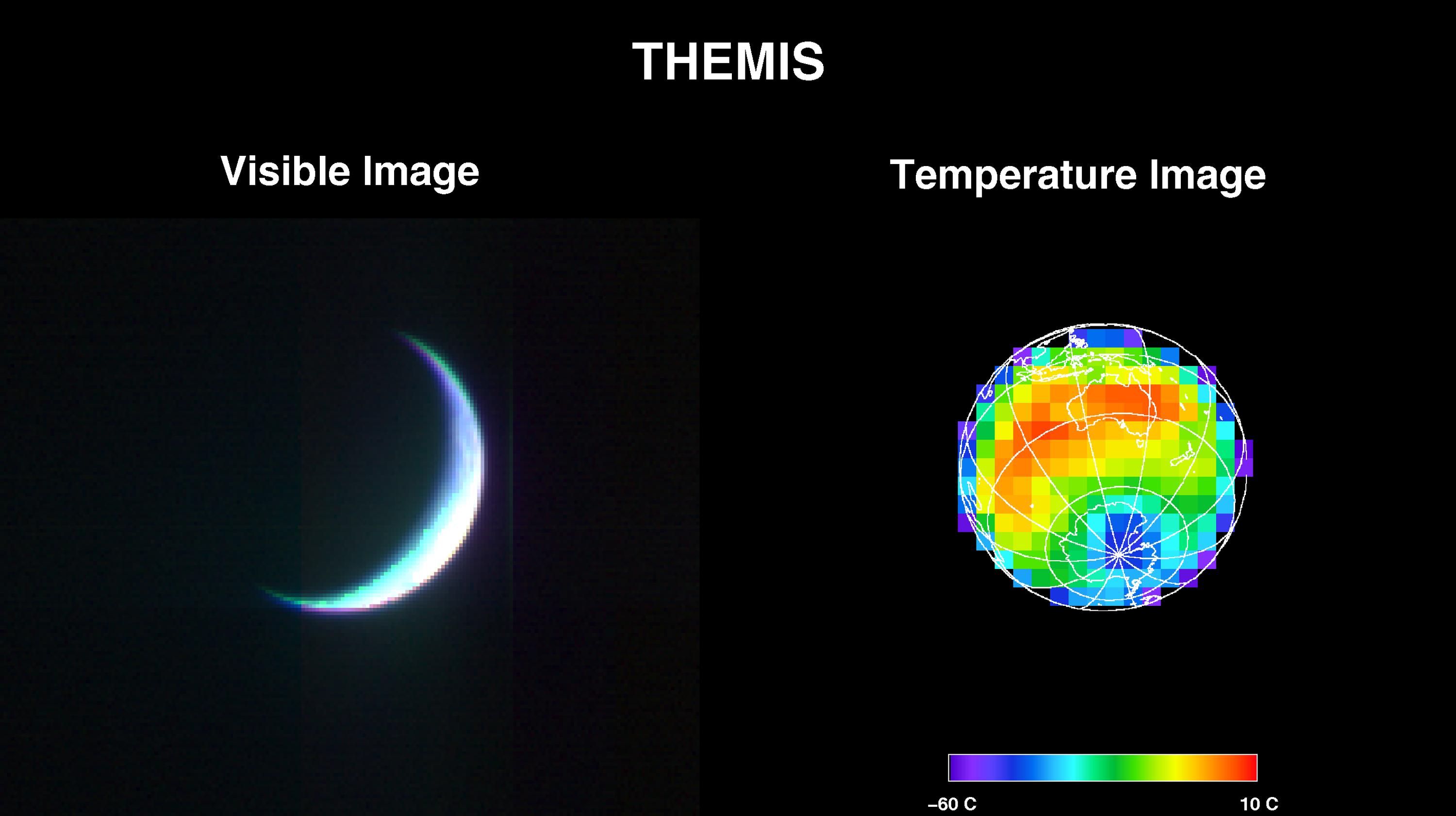
2001-04-26 | Earth |
2001 Mars Odyssey |
THEMIS |
3000x1681x3 |
|
|||||
|
|
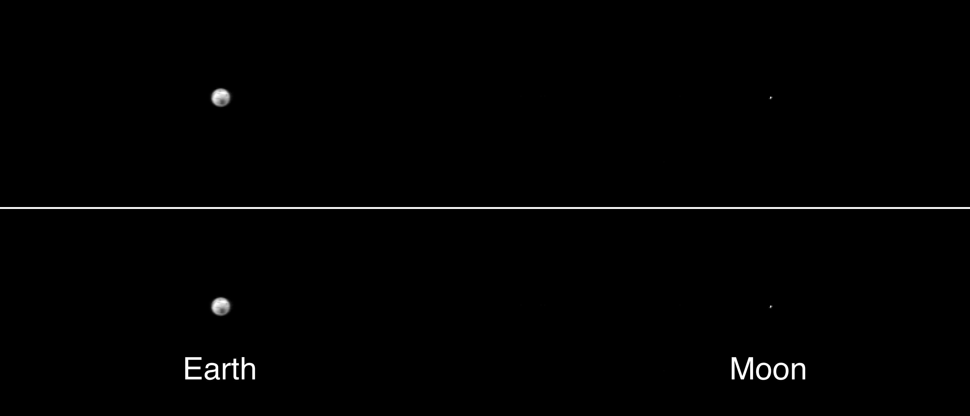
2001-05-01 | Earth |
2001 Mars Odyssey |
THEMIS |
3124x1342x1 |
|
|||||
|
|
2009-06-26 | Mars |
2001 Mars Odyssey |
THEMIS |
1297x2904x1 |
|
|
|||||
|
|
2022-08-25 | Mars |
2001 Mars Odyssey |
THEMIS |
670x1419x1 |
|
|
|||||
|
|
2001-11-09 | Mars |
2001 Mars Odyssey |
THEMIS |
1990x2192x3 |

|
|||||
|
|
2001-11-13 | Mars |
2001 Mars Odyssey |
THEMIS |
3658x2671x3 |
|
|||||
|
|
2002-03-05 | Mars |
2001 Mars Odyssey |
THEMIS |
952x474x1 |
|
|||||
|
|
2002-03-01 | Mars |
2001 Mars Odyssey |
THEMIS |
697x314x1 |
|
|||||
|
|
2002-03-01 | Mars |
2001 Mars Odyssey |
THEMIS |
2920x600x1 |
|
|||||
|
|
2002-03-01 | Mars |
2001 Mars Odyssey |
THEMIS |
665x302x3 |
|
|||||
|
|
2002-03-01 | Mars |
2001 Mars Odyssey |
THEMIS |
1063x320x1 |
|
|||||
|
|
2003-01-13 | Mars |
2001 Mars Odyssey |
THEMIS |
320x1404x1 |
|
|
|||||
|
|
2002-04-25 | Mars |
2001 Mars Odyssey |
THEMIS |
1212x3061x1 |
|
|
|||||
|
|
2002-05-21 | Mars |
2001 Mars Odyssey |
THEMIS |
1183x3061x1 |
|
|
|||||
 |
 |
|
|
|
|
|
|
|
|

|
|
| 1-100 | 101-200 | 201-300 | 301-400 | 401-500 | 501-600 | 601-700 | 701-800 | 801-900 | 901-1000 |
| Currently displaying images: 1 - 100 of 5575 |