My
List |
Addition Date
|
Target
|
Mission
|
Instrument
|
Size
|

|
2008-11-18 |
Mars
|
2001 Mars Odyssey
|
Gamma Ray Spectrometer
Laser Altimeter
|
850x650x3 |
|
-
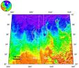
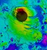
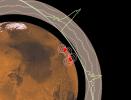
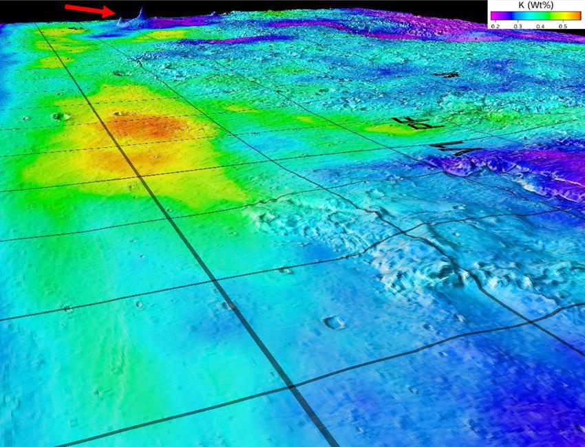
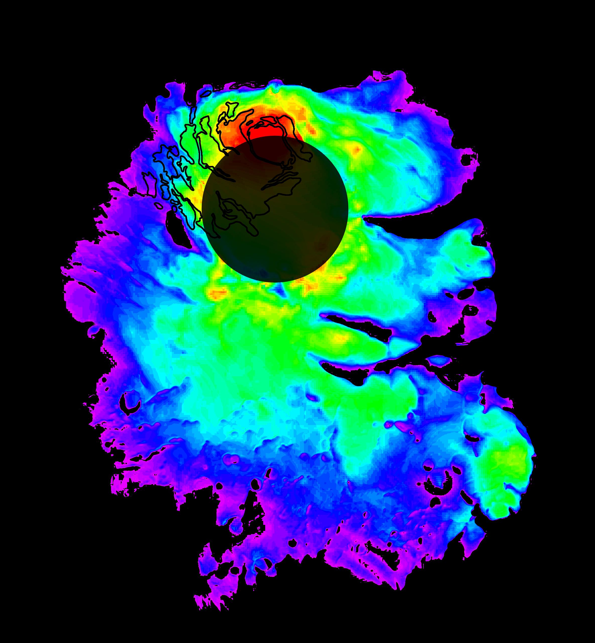
PIA11421:
-
Potassium Concentrations on Mars
Full Resolution:
TIFF
(1.659 MB)
JPEG
(122.3 kB)
|
|
|
2003-12-18 |
Mars
|
2001 Mars Odyssey
Mars Global Surveyor (MGS)
|
Mars Orbiter Camera (MOC)
Thermal Emission Imaging System
Visual Imaging Subsystem
|
2880x2880x3 |

|
-
PIA04933:
-
Mars Ice Age, Simulated
Full Resolution:
TIFF
(15.45 MB)
JPEG
(717.5 kB)
|
|
|
2005-05-19 |
|
2001 Mars Odyssey
Mars Global Surveyor (MGS)
|
Mars Orbiter Camera (MOC)
|
627x393x1 |

|
-
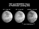
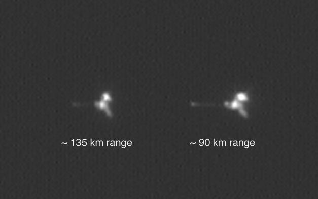
PIA07941:
-
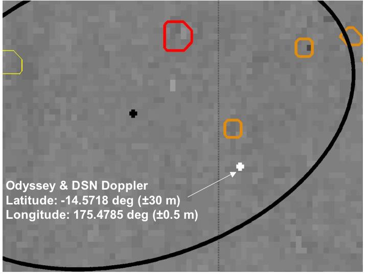
Mars Odyssey from Two Distances in One Image
Full Resolution:
TIFF
(246.9 kB)
JPEG
(14 kB)
|
|
|
2005-05-19 |
|
2001 Mars Odyssey
Mars Global Surveyor (MGS)
|
Mars Orbiter Camera (MOC)
|
350x350x3 |
|
-
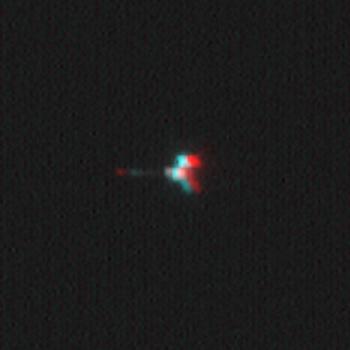
PIA07943:
-
Mars Odyssey Seen by Mars Global Surveyor (3-D)
Full Resolution:
TIFF
(368.1 kB)
JPEG
(8.865 kB)
|
|
|
2005-05-19 |
|
2001 Mars Odyssey
Mars Global Surveyor (MGS)
|
Mars Orbiter Camera (MOC)
|
488x513x1 |

|
-
PIA07942:
-
Mars Odyssey Seen by Mars Global Surveyor
Full Resolution:
TIFF
(250.8 kB)
JPEG
(7.568 kB)
|
|
|
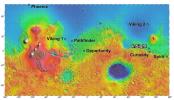
2011-03-08 |
Mars
|
2001 Mars Odyssey
Mars Global Surveyor (MGS)
|
MOLA
THEMIS
|
708x605x3 |
|
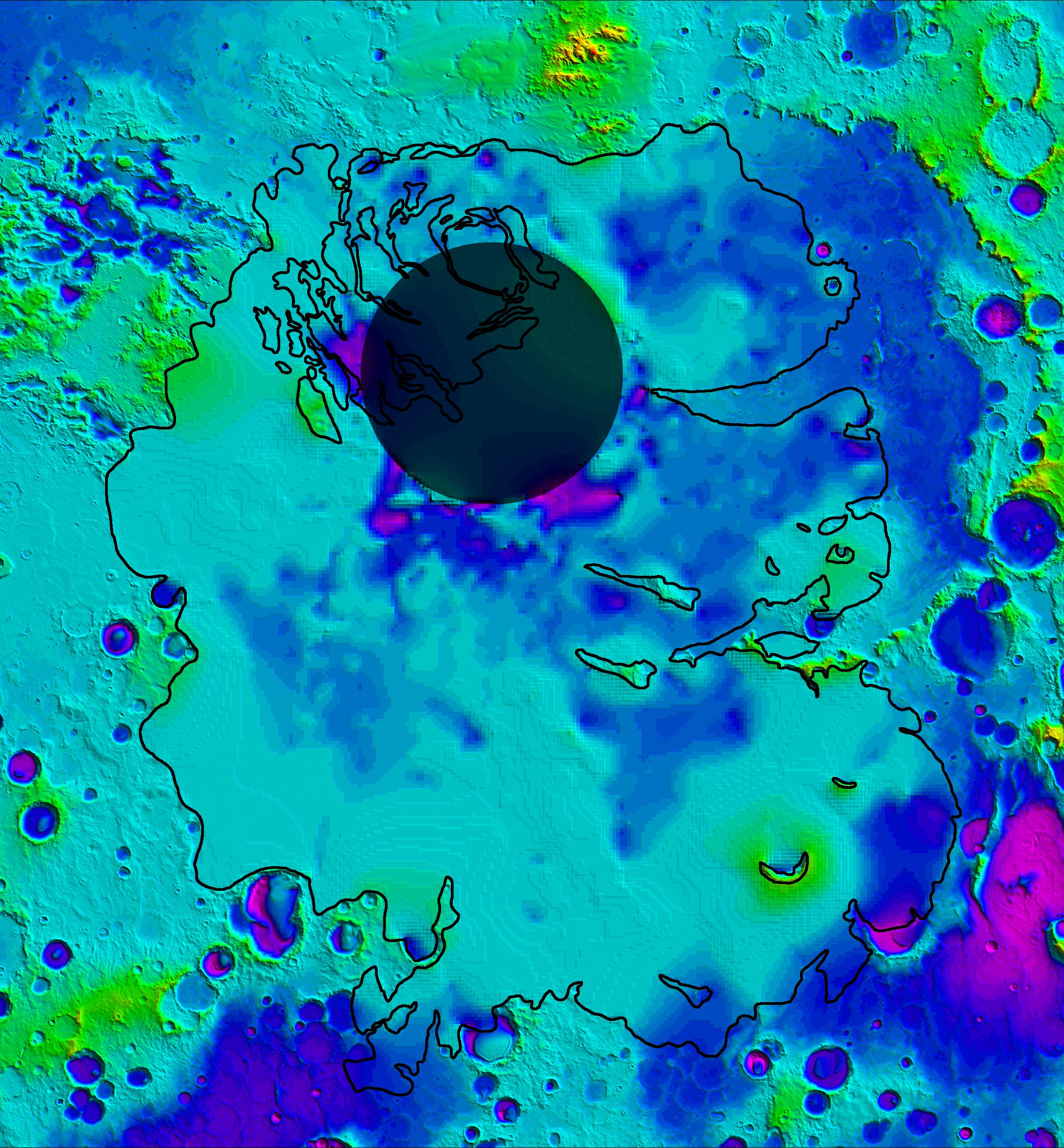
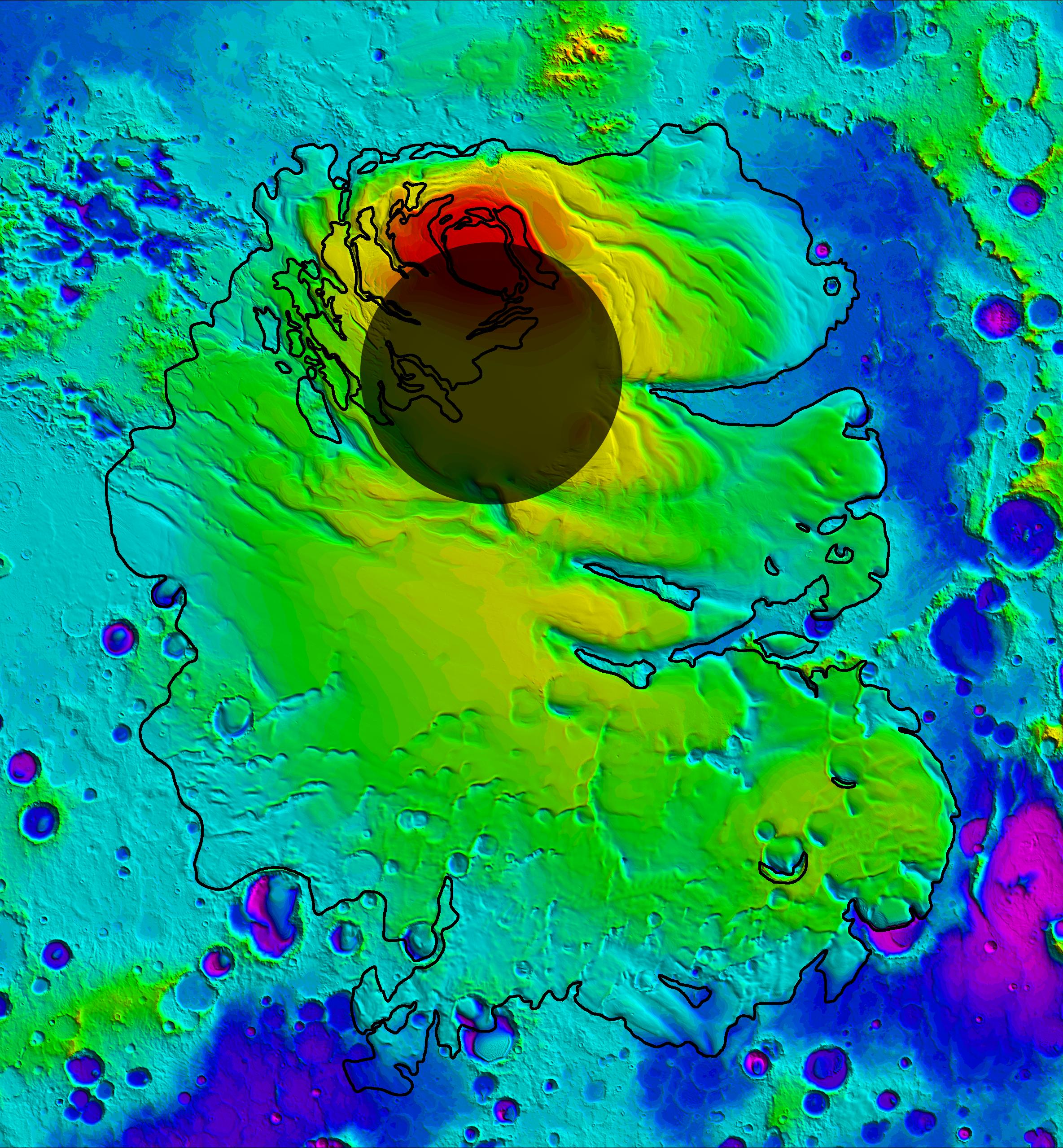
-
PIA13801:
-
Nature's Drilling Exposes Deeply Buried Minerals
Full Resolution:
TIFF
(1.287 MB)
JPEG
(85.93 kB)
|
|
|
2013-12-10 |
Mars
|
2001 Mars Odyssey
Mars Global Surveyor (MGS)
|
MOLA
THEMIS
|
960x665x3 |
|
-
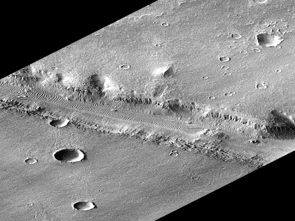
PIA17607:
-
Maps of Recurrent Slope Linea Markings on Mars
Full Resolution:
TIFF
(1.916 MB)
JPEG
(143.3 kB)
|
|
|
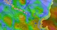
2016-09-15 |
Mars
|
2001 Mars Odyssey
Mars Global Surveyor (MGS)
|
MOLA
THEMIS
|
1316x1840x3 |

|
-
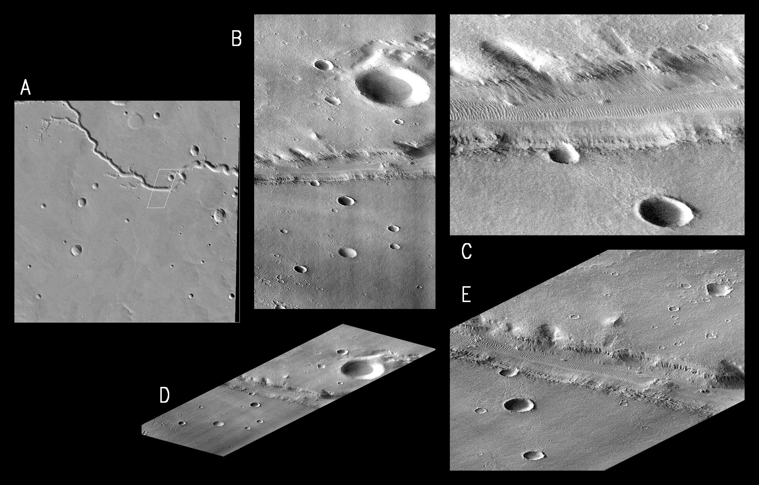
PIA20838:
-
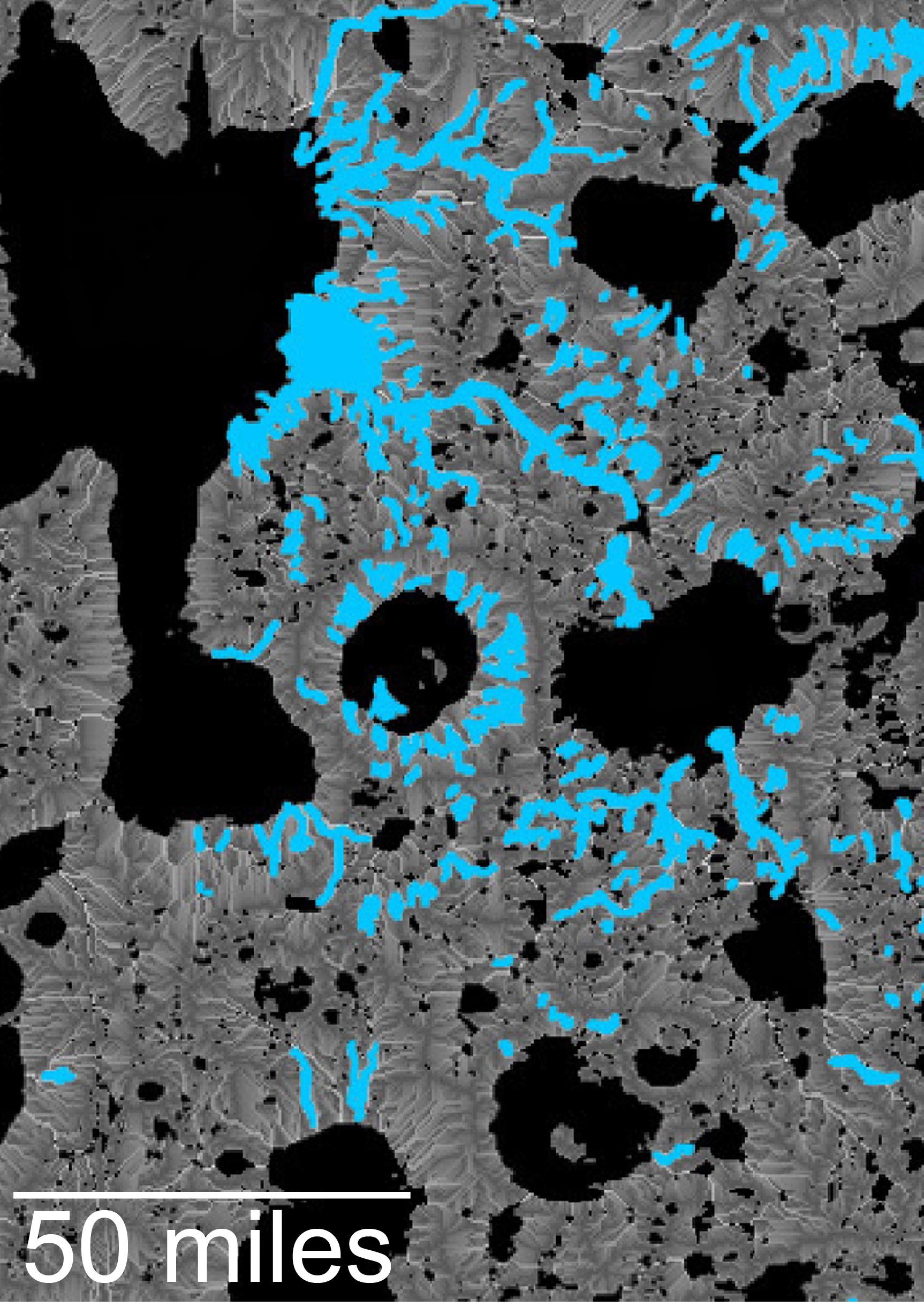
Landscape of Former Lakes and Streams on Northern Mars
Full Resolution:
TIFF
(7.267 MB)
JPEG
(409.9 kB)
|
|
|
2016-09-15 |
Mars
|
2001 Mars Odyssey
Mars Global Surveyor (MGS)
|
MOLA
THEMIS
|
1726x2453x3 |
|
-
PIA20839:
-
Hydrologic Modeling of Relatively Recent Martian Streams and Lake
Full Resolution:
TIFF
(7.388 MB)
JPEG
(549.4 kB)
|
|
|
2004-01-13 |
Mars
|
2001 Mars Odyssey
Mars Global Surveyor (MGS)
Mars Exploration Rover (MER)
|
Mars Orbiter Camera (MOC)
Thermal Emission Imaging System
|
720x540x3 |
|
-
PIA05055:
-
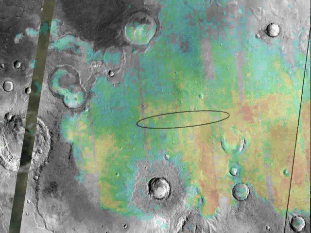
Right on Target
Full Resolution:
TIFF
(337.8 kB)
JPEG
(41.77 kB)
|
|
|
2004-01-13 |
Mars
|
2001 Mars Odyssey
Mars Global Surveyor (MGS)
Mars Exploration Rover (MER)
|
Mars Orbiter Camera (MOC)
Thermal Emission Imaging System
|
720x540x3 |
|
-
PIA05056:
-
Right on Target-2
Full Resolution:
TIFF
(302 kB)
JPEG
(36.3 kB)
|
|
|
2004-01-23 |
Mars
|
2001 Mars Odyssey
Mars Global Surveyor (MGS)
Mars Exploration Rover (MER)
|
THEMIS
THEMIS
|
640x480x3 |
|
-
PIA05154:
-
Targeting a Hematite-rich Terrain
Full Resolution:
TIFF
(922.8 kB)
JPEG
(52.31 kB)
|
|
|
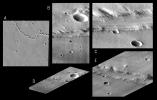
2004-02-09 |
Mars
|
2001 Mars Odyssey
Mars Global Surveyor (MGS)
Mars Exploration Rover (MER)
|
Descent Image Motion Estimation System (DIMES)
Mars Orbiter Camera (MOC)
Thermal Emission Imaging System
|
4000x5308x3 |
|
-
PIA05228:
-
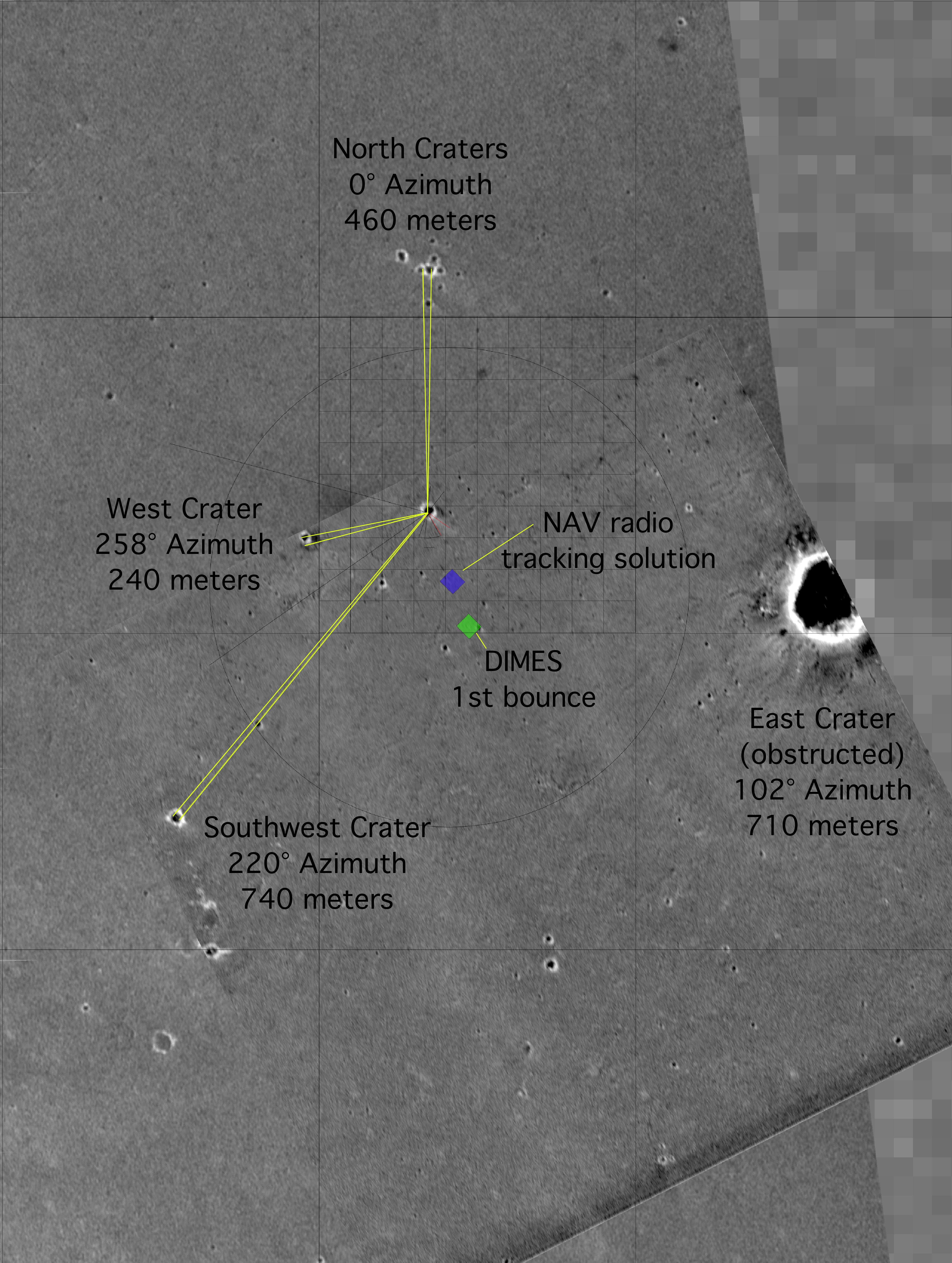
"X" Marks the Spot
Full Resolution:
TIFF
(11.63 MB)
JPEG
(2.084 MB)
|
|
|
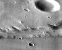
2004-03-18 |
Mars
|
2001 Mars Odyssey
Mars Global Surveyor (MGS)
Mars Exploration Rover (MER)
|
Mars Orbiter Camera (MOC)
Thermal Emission Imaging System
|
1051x681x3 |

|
-
PIA05581:
-
To 'Bonneville' and Beyond
Full Resolution:
TIFF
(2.15 MB)
JPEG
(98.5 kB)
|
|
|
2004-03-19 |
Mars
|
2001 Mars Odyssey
Mars Global Surveyor (MGS)
Mars Exploration Rover (MER)
|
Mars Orbiter Camera (MOC)
Thermal Emission Imaging System
|
1920x1080x3 |
|
-
PIA05590:
-
Ma'adim Vallis From the Top
Full Resolution:
TIFF
(1.295 MB)
JPEG
(85.07 kB)
|
|
|
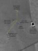
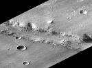
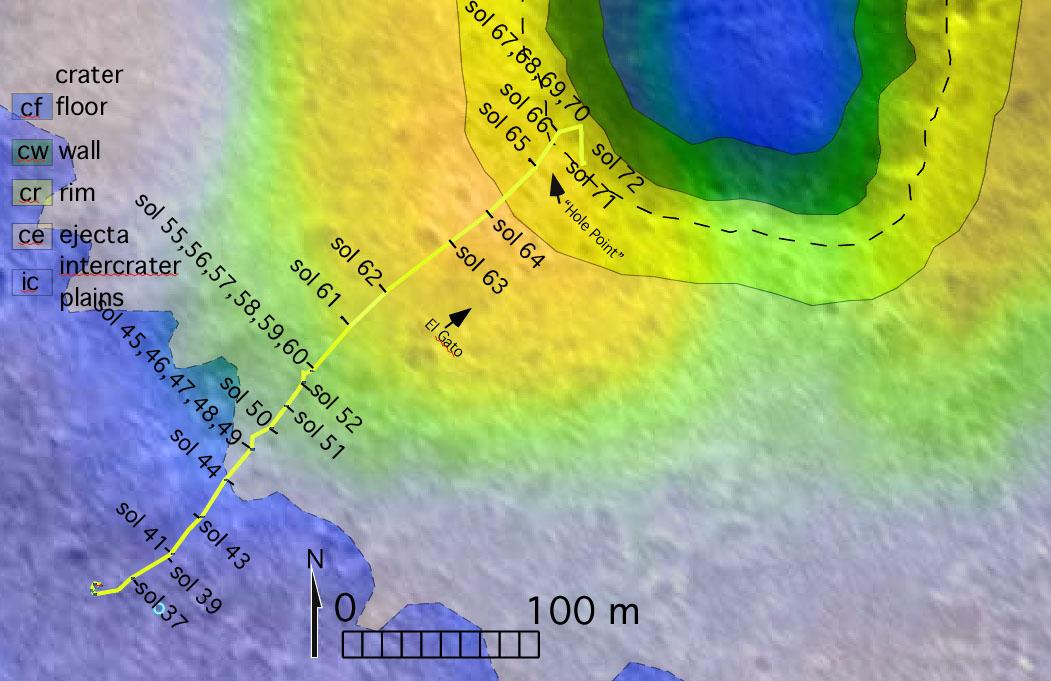
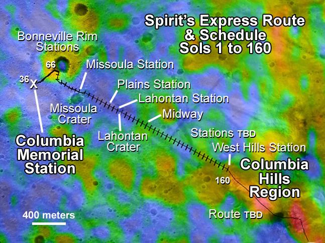
2004-04-28 |
Mars
|
2001 Mars Odyssey
Mars Global Surveyor (MGS)
Mars Exploration Rover (MER)
|
Mars Orbiter Camera (MOC)
Thermal Emission Imaging System
|
647x485x3 |
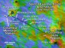
|
-
PIA05834:
-
Spirit's Express Route to 'Columbia Hills'
Full Resolution:
TIFF
(942.6 kB)
JPEG
(81.41 kB)
|
|
|
2004-04-29 |
Mars
|
2001 Mars Odyssey
Mars Global Surveyor (MGS)
Mars Exploration Rover (MER)
|
Mars Orbiter Camera (MOC)
Thermal Emission Imaging System
|
671x455x3 |

|
-
PIA05836:
-
Confirming Predictions
Full Resolution:
TIFF
(917.1 kB)
JPEG
(56.25 kB)
|
|
|
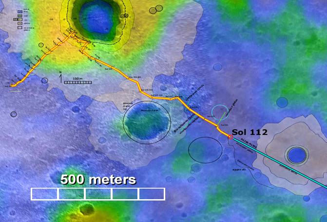
2004-07-16 |
Mars
|
2001 Mars Odyssey
Mars Global Surveyor (MGS)
Mars Exploration Rover (MER)
|
Mars Orbiter Camera (MOC)
Thermal Emission Spectrometer
|
1183x638x3 |
|
-
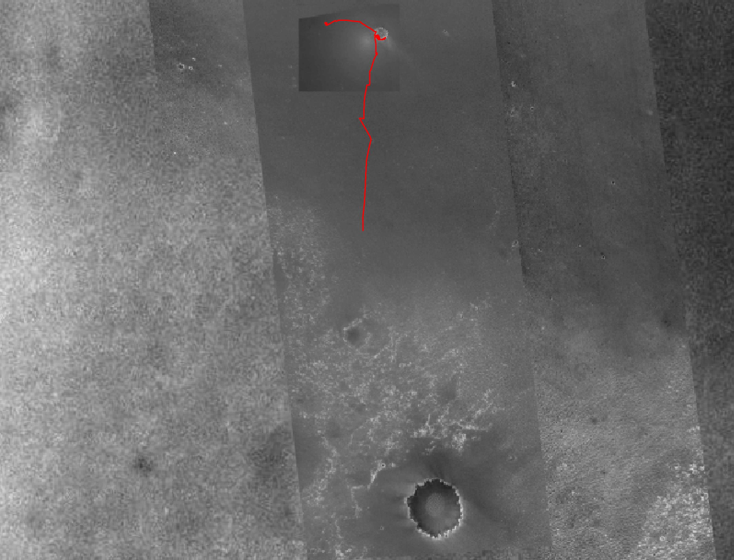
PIA06688:
-
Spirit Traverse Map
Full Resolution:
TIFF
(2.267 MB)
JPEG
(102.9 kB)
|
|
|
2005-12-05 |
Mars
|
2001 Mars Odyssey
Mars Global Surveyor (MGS)
Mars Exploration Rover (MER)
|
Descent Image Motion Estimation System (DIMES)
Mars Orbiter Camera
Thermal Emission Imaging System
|
1411x2043x3 |
|
-
PIA03616:
-
Partway to 'Victoria'
Full Resolution:
TIFF
(8.665 MB)
JPEG
(265.7 kB)
|
|
|
2011-07-06 |
Mars
|
2001 Mars Odyssey
Mars Global Surveyor (MGS)
Mars Science Laboratory (MSL)
|
MOLA
THEMIS
|
1920x1080x3 |
|
-
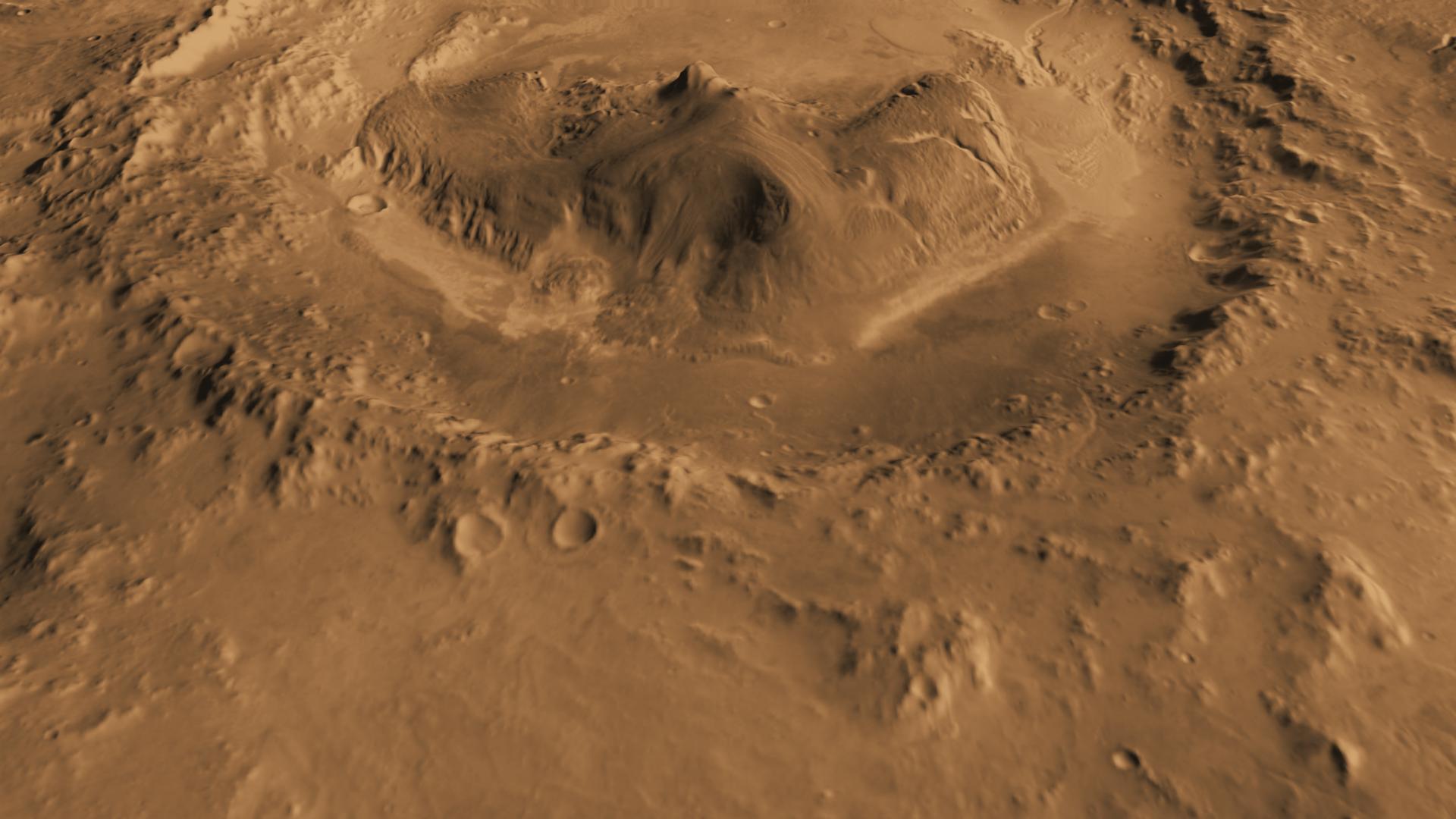
PIA14291:
-
Oblique view of Gale Crater from the North
Full Resolution:
TIFF
(6.23 MB)
JPEG
(170.8 kB)
|
|
|
2013-06-11 |
Mars
|
2001 Mars Odyssey
Mars Reconnaissance Orbiter (MRO)
Mars Global Surveyor (MGS)
|
HiRISE
Mars Orbiter Camera (MOC)
THEMIS
|
960x608x3 |
|
-
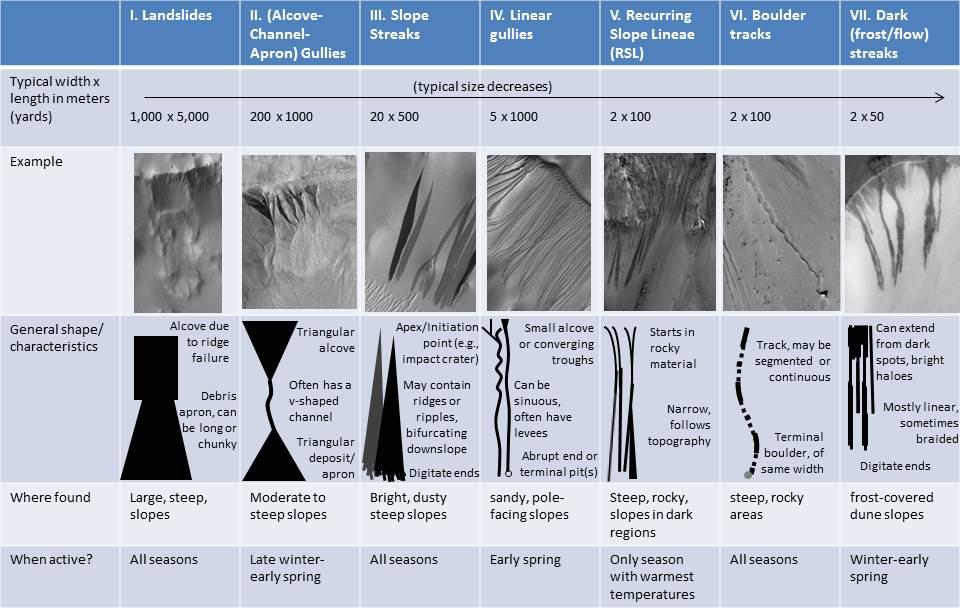
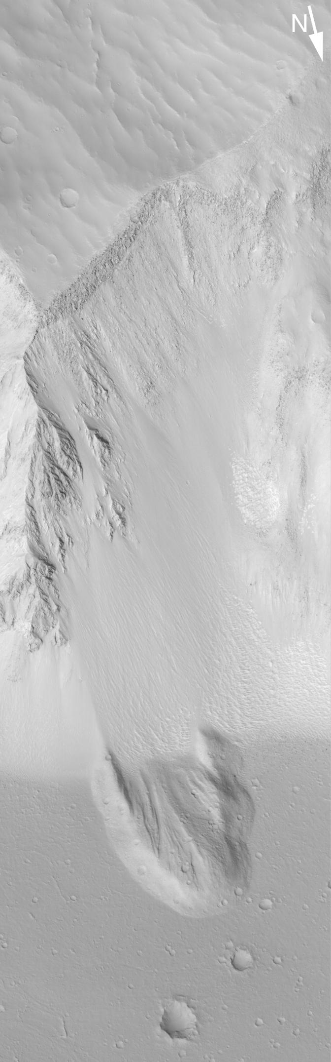
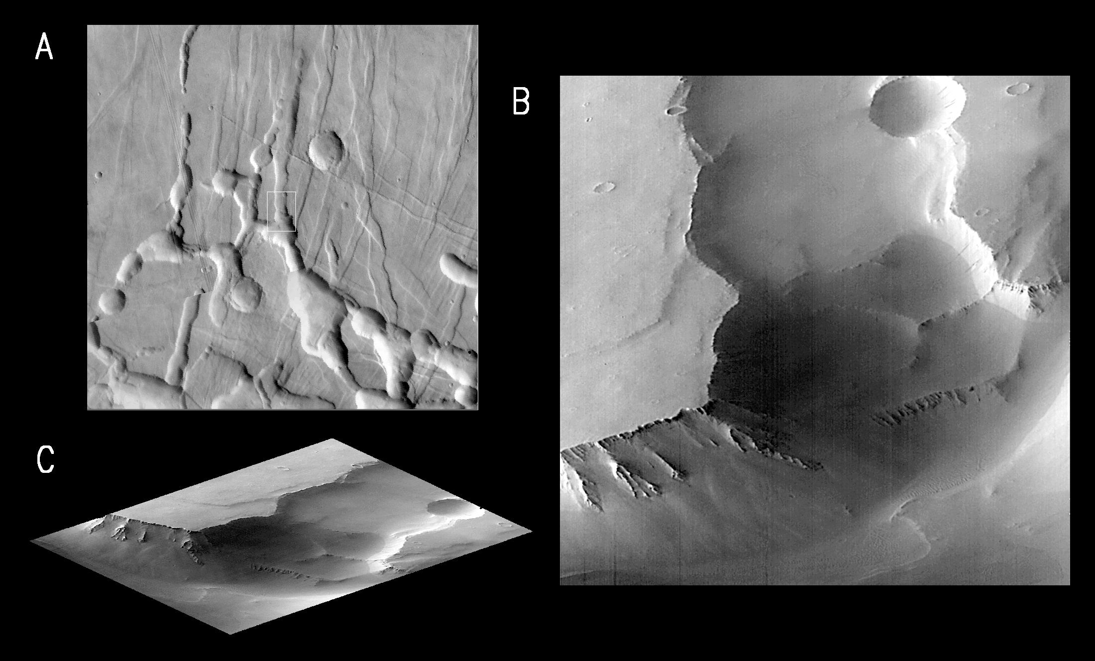
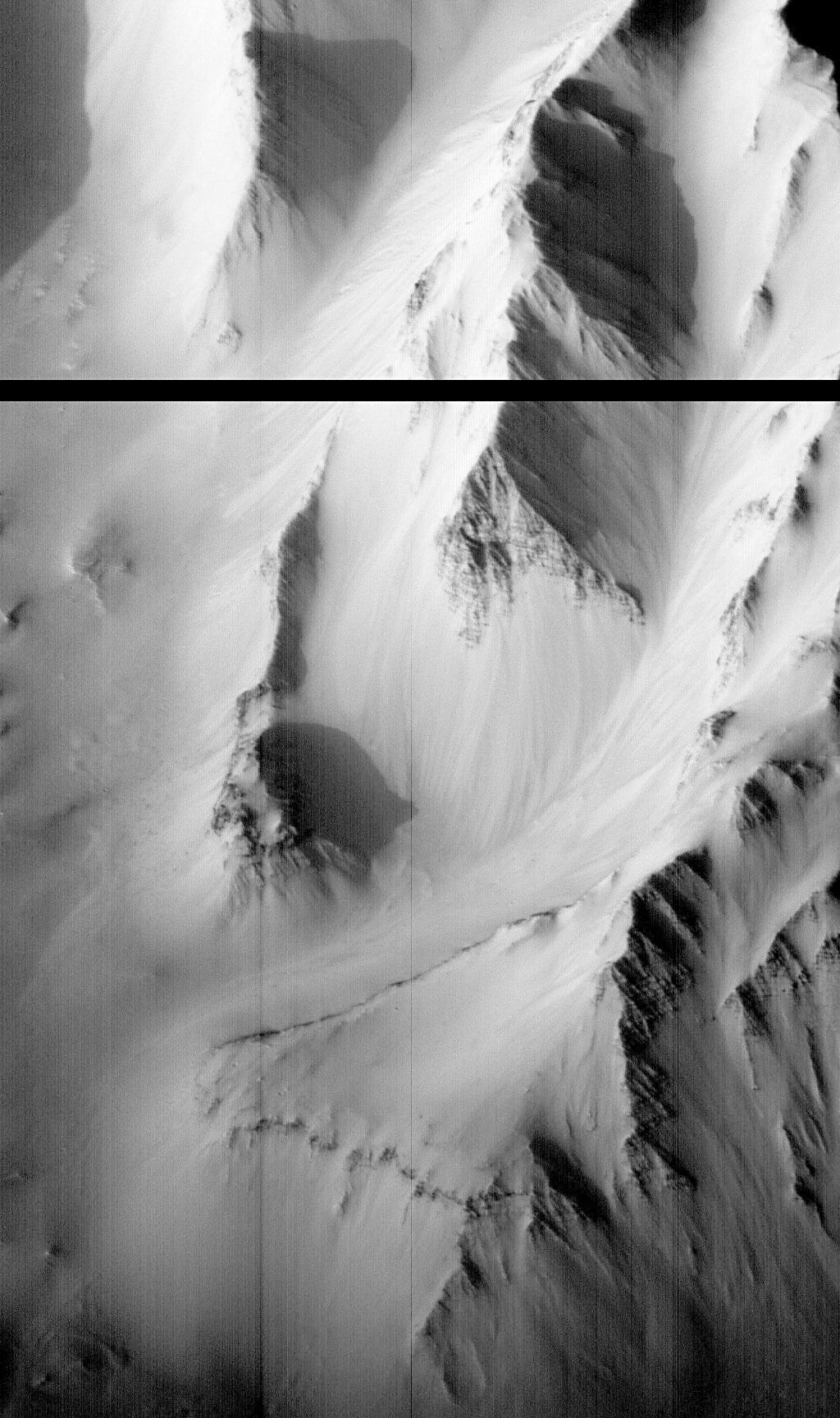
PIA17079:
-
Martian Features Formed When Material Moves Downslope
Full Resolution:
TIFF
(1.752 MB)
JPEG
(100.9 kB)
|
|
|
2019-12-10 |
Mars
|
2001 Mars Odyssey
Mars Reconnaissance Orbiter (MRO)
Mars Global Surveyor (MGS)
|
MCS
THEMIS
|
1614x720x3 |
|
-
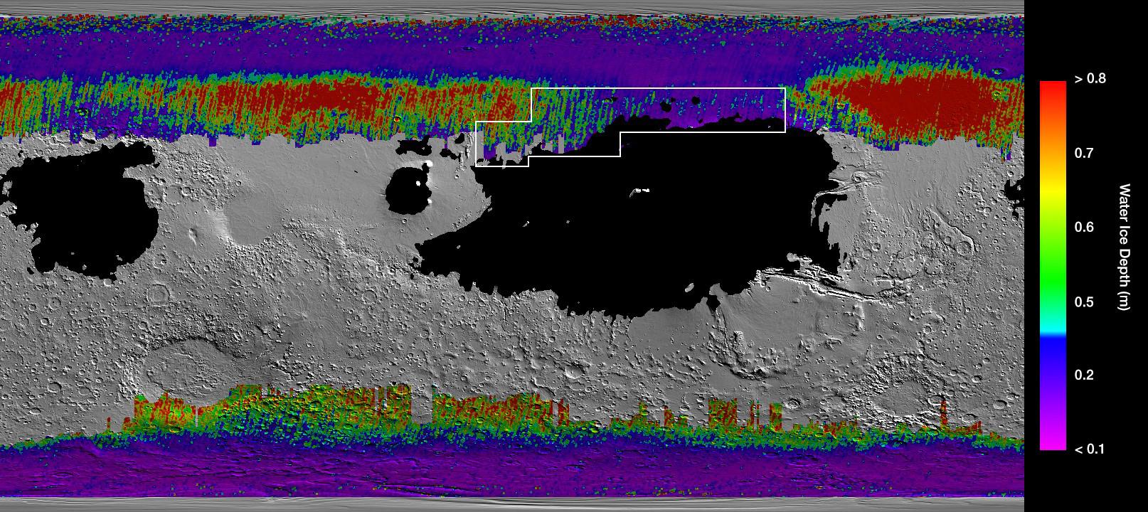
PIA23514:
-
A Water Ice Map for Mars
Full Resolution:
TIFF
(2.369 MB)
JPEG
(311.5 kB)
|
|
|
2000-11-03 |
Mars
|
Galileo
Mars Global Surveyor (MGS)
|
Mars Orbiter Camera (MOC)
Solid-State Imaging
|
2800x1824x3 |
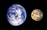
|
-
PIA02570:
-
Earth Mars Comparison
Full Resolution:
TIFF
(5.946 MB)
JPEG
(269.4 kB)
|
|
|
2013-09-04 |
Mars
|
InSight
Mars Global Surveyor (MGS)
|
MOLA
|
4000x2298x3 |
|
-
PIA17357:
-
NASA's Mars Landing Sites, including InSight
Full Resolution:
TIFF
(27.59 MB)
JPEG
(2.27 MB)
|
|
|
2004-02-11 |
Mars
|
Mars Exploration Rover (MER)
|
Panoramic Camera
|
645x503x1 |
|
-
PIA05256:
-
Unparallel Lines Give Unparalleled Clues
Full Resolution:
TIFF
(291.2 kB)
JPEG
(32.66 kB)
|
|
|
2004-08-27 |
Mars
|
Mars Exploration Rover (MER)
|
Mars Orbiter Camera (MOC)
|
672x2151x1 |

|
-
PIA06834:
-
Landslide in Sirenum
Full Resolution:
TIFF
(1.303 MB)
JPEG
(136.2 kB)
|
|
|
2005-03-30 |
Mars
|
Mars Exploration Rover (MER)
Mars Global Surveyor (MGS)
2001 Mars Odyssey
|
Descent Image Motion Estimation System (DIMES)
Mars Orbiter Camera
Thermal Emission Imaging System
|
2392x1823x3 |
|
-
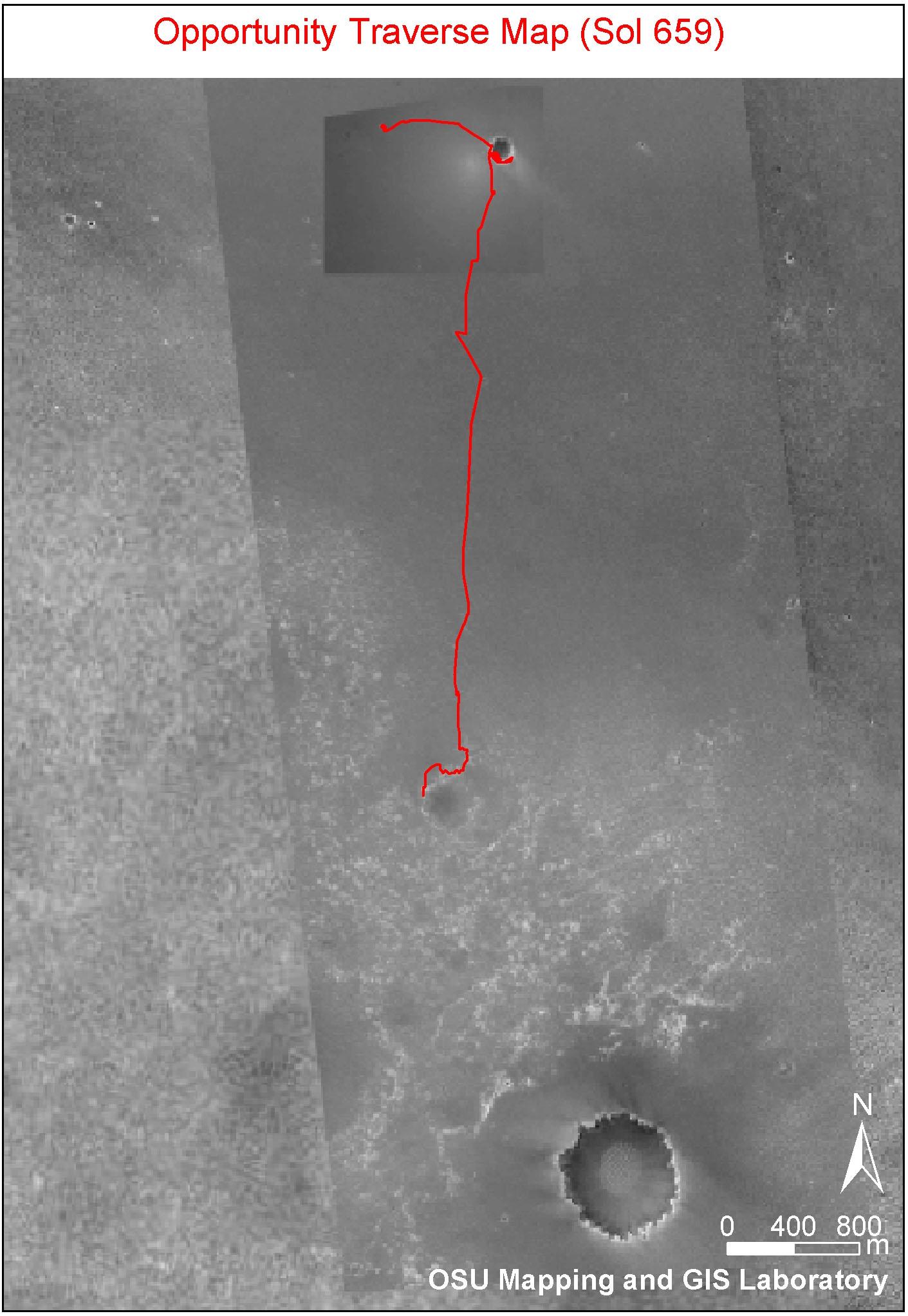
PIA07506:
-
Opportunity's Fast Progress Southward
Full Resolution:
TIFF
(5.086 MB)
JPEG
(406.4 kB)
|
|
|
2005-11-30 |
Mars
|
Mars Express (MEX)
Mars Global Surveyor (MGS)
|
MARSIS
Mars Orbiter Laser Altimeter
|
979x666x3 |

|
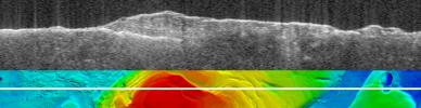
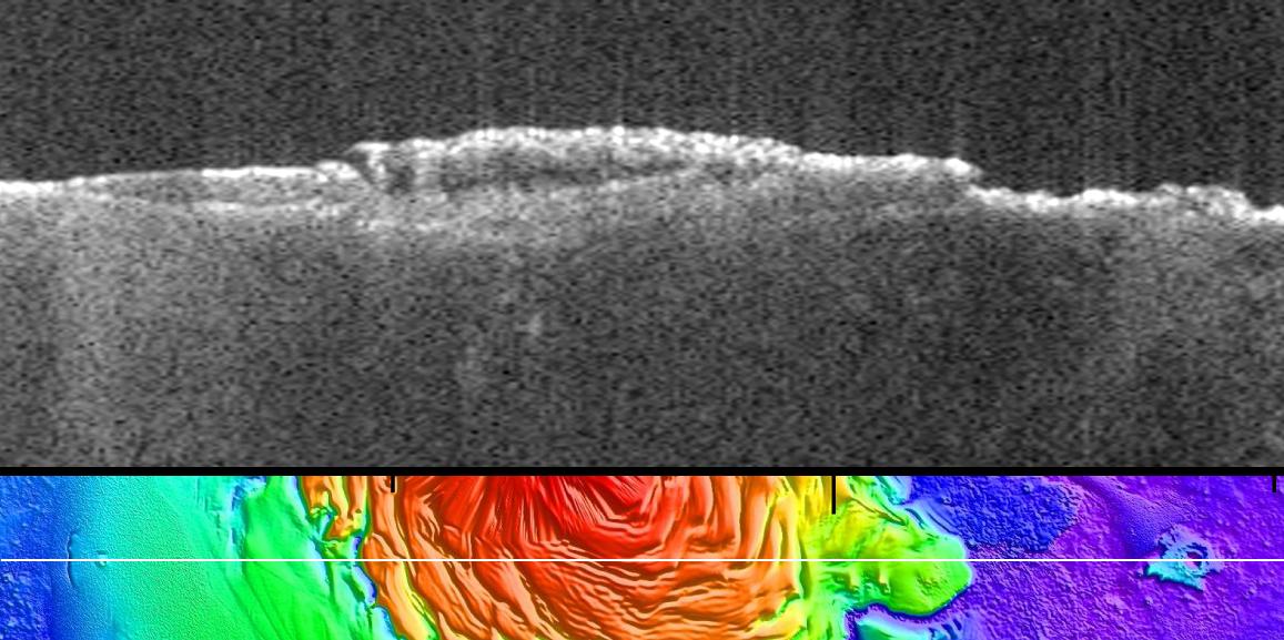
-
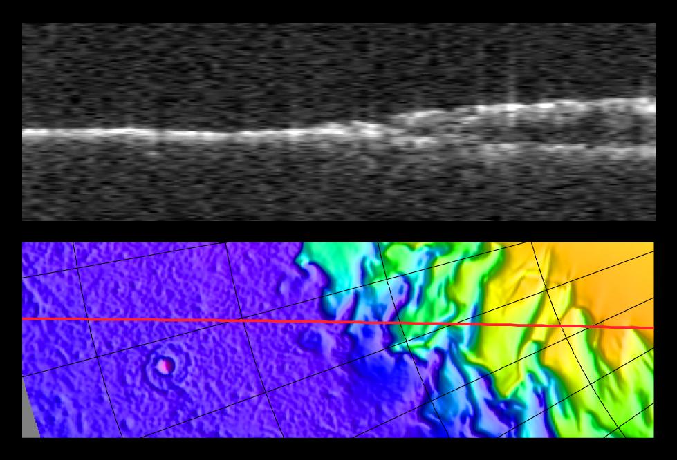
PIA03235:
-
Radargram of Mars' North Polar Layered Deposits with Topographic Map
Full Resolution:
TIFF
(1.959 MB)
JPEG
(95.14 kB)
|
|
|
2005-11-30 |
Mars
|
Mars Express (MEX)
Mars Global Surveyor (MGS)
|
Mars Advanced Radar for Subsurface and Ionospheric Sounding
(MARSIS)
Mars Orbiter Laser Altimeter
|
788x683x3 |
|
-
PIA03237:
-
Topographic Map of Chryse Planitia with Location of Possible Buried Basin
Full Resolution:
TIFF
(1.617 MB)
JPEG
(106.2 kB)
|
|
|
2007-03-15 |
Mars
|
Mars Express (MEX)
Mars Global Surveyor (MGS)
|
MARSIS
Mars Orbiter Laser Altimeter
|
1784x460x3 |
|
-
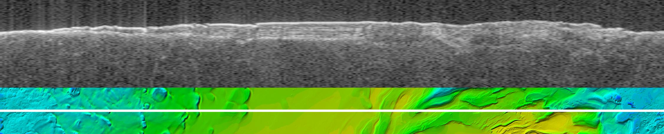
PIA09222:
Bright Lower Echo in Radargram of South Polar Layered Deposits
Full Resolution:
TIFF
(2.466 MB)
JPEG
(124.4 kB)
|
|
|
2007-03-15 |
Mars
|
Mars Express (MEX)
Mars Global Surveyor (MGS)
|
MARSIS
Mars Orbiter Laser Altimeter
|
2251x457x3 |

|
-
PIA09223:
Virtual Slice Through Icy Layered Deposits Near Mars' South Pole
Full Resolution:
TIFF
(3.09 MB)
JPEG
(149.5 kB)
|
|
|
2007-03-15 |
Mars
|
Mars Express (MEX)
Mars Global Surveyor (MGS)
|
MARSIS
Mars Orbiter Laser Altimeter
|
2369x2558x3 |
|
-
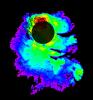
PIA09224:
-
Thickness of Mars' South Polar Layered Deposits
Full Resolution:
TIFF
(18.2 MB)
JPEG
(462.9 kB)
|
|
|
2007-03-15 |
Mars
|
Mars Express (MEX)
Mars Global Surveyor (MGS)
|
MARSIS
Mars Orbiter Laser Altimeter
|
2369x2558x3 |
|
-
PIA09225:
-
Lower Boundary of Icy Layers Covering Mars' South Polar Region
Full Resolution:
TIFF
(18.2 MB)
JPEG
(938.3 kB)
|
|
|
2007-03-15 |
Mars
|
Mars Express (MEX)
Mars Global Surveyor (MGS)
|
MARSIS
Mars Orbiter Laser Altimeter
|
2369x2558x3 |
|
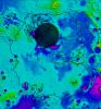
-
PIA09226:
-
Upper Surface of Icy Layers Covering Mars' South Polar Region
Full Resolution:
TIFF
(18.2 MB)
JPEG
(1.033 MB)
|
|
|
2011-12-19 |
Mars
|
Mars Express (MEX)
Mars Global Surveyor (MGS)
|
MARSIS
MOLA
|
1157x577x3 |

|
-
PIA15117:
-
Radargram of Mars North Polar Plateau from Mars Express
Full Resolution:
TIFF
(2.005 MB)
JPEG
(120 kB)
|
|
|
1997-07-04 |
Mars
|
Mars Global Surveyor (MGS)
|
Mars Orbiter Camera (MOC)
|
512x512x1 |

|
-
PIA00606:
-
Mars Global Surveyor Approach Image
Full Resolution:
TIFF
(8.131 kB)
JPEG
(4.696 kB)
|
|
|
1997-07-04 |
Mars
|
Mars Global Surveyor (MGS)
|
Mars Orbiter Camera (MOC)
|
640x480x1 |
|
-
PIA00607:
-
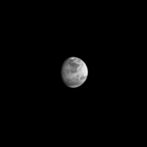
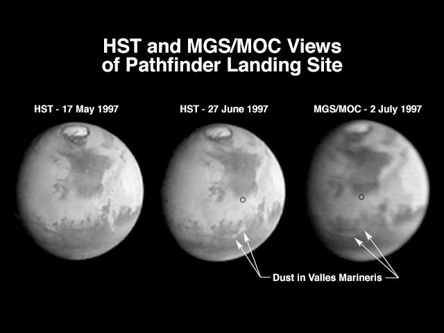
Hubble and Mars Global Surveyor Views of Dust Storm on Mars
Full Resolution:
TIFF
(86.26 kB)
JPEG
(27.45 kB)
|
|
|
1998-03-13 |
Mars
|
Mars Global Surveyor (MGS)
|
Mars Orbiter Camera (MOC)
|
573x906x1 |
|
-
PIA00800:
-
Medusae Fossae #1
Full Resolution:
TIFF
(291.2 kB)
JPEG
(136.8 kB)
|
|
|
1998-03-13 |
Mars
|
Mars Global Surveyor (MGS)
|
Mars Orbiter Camera (MOC)
|
573x906x1 |
|
-
PIA00801:
-
Medusae Fossae #2
Full Resolution:
TIFF
(280.2 kB)
JPEG
(129.4 kB)
|
|
|
1998-03-13 |
Mars
|
Mars Global Surveyor (MGS)
|
Mars Orbiter Camera (MOC)
|
450x699x1 |
|
-
PIA00802:
-
Hebes Chasma #1
Full Resolution:
TIFF
(155.5 kB)
JPEG
(72.56 kB)
|
|
|
1998-03-13 |
Mars
|
Mars Global Surveyor (MGS)
|
Mars Orbiter Camera (MOC)
|
450x699x1 |
|
-
PIA00803:
-
Hebes Chasma #2
Full Resolution:
TIFF
(160 kB)
JPEG
(71.49 kB)
|
|
|
1998-03-13 |
Mars
|
Mars Global Surveyor (MGS)
|
Mars Orbiter Camera (MOC)
|
645x701x1 |
|
-
PIA00804:
-
Crommelin Crater #1
Full Resolution:
TIFF
(201.9 kB)
JPEG
(78.6 kB)
|
|
|
1998-03-13 |
Mars
|
Mars Global Surveyor (MGS)
|
Mars Orbiter Camera (MOC)
|
645x701x1 |
|
-
PIA00805:
-
Crommelin Crater #2
Full Resolution:
TIFF
(224.5 kB)
JPEG
(87.85 kB)
|
|
|
1998-03-13 |
Mars
|
Mars Global Surveyor (MGS)
|
Mars Orbiter Camera (MOC)
|
477x441x1 |
|
-
PIA00806:
-
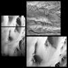
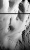
Tithonium Chasma/Ius Chasma
Full Resolution:
TIFF
(110.4 kB)
JPEG
(46.77 kB)
|
|
|
1998-03-13 |
Mars
|
Mars Global Surveyor (MGS)
|
Mars Orbiter Camera (MOC)
|
477x441x1 |
|
-
PIA00807:
-
Candor Chasma
Full Resolution:
TIFF
(109.9 kB)
JPEG
(47.99 kB)
|
|
|
1998-03-13 |
Mars
|
Mars Global Surveyor (MGS)
|
Mars Orbiter Camera (MOC)
|
855x616x1 |
|
-
PIA00808:
-
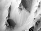
Ridges in Mars' South Polar Region
Full Resolution:
TIFF
(227.3 kB)
JPEG
(73.71 kB)
|
|
|
1998-03-13 |
Mars
|
Mars Global Surveyor (MGS)
|
Mars Orbiter Camera (MOC)
|
592x568x1 |
|
-
PIA00809:
-
Textures in South Polar Ice Cap #1
Full Resolution:
TIFF
(173.4 kB)
JPEG
(76.65 kB)
|
|
|
1998-03-13 |
Mars
|
Mars Global Surveyor (MGS)
|
Mars Orbiter Camera (MOC)
|
592x568x1 |
|
-
PIA00810:
-
Textures in South Polar Ice Cap #2
Full Resolution:
TIFF
(147.8 kB)
JPEG
(52.01 kB)
|
|
|
1998-03-13 |
Mars
|
Mars Global Surveyor (MGS)
|
Mars Orbiter Camera (MOC)
|
1200x1194x1 |

|
-
PIA00811:
-
South Polar Region
Full Resolution:
TIFF
(402.9 kB)
JPEG
(109.9 kB)
|
|
|
1998-03-13 |
Mars
|
Mars Global Surveyor (MGS)
|
Mars Orbiter Camera (MOC)
|
1200x1194x3 |
|
-
PIA00812:
-
Clouds over Tharsis
Full Resolution:
TIFF
(439 kB)
JPEG
(75.45 kB)
|
|
|
1998-03-13 |
Mars
|
Mars Global Surveyor (MGS)
|
Mars Orbiter Camera (MOC)
|
1200x1194x1 |
|
-
PIA00813:
-
1997 Martian Dust Storm
Full Resolution:
TIFF
(310.8 kB)
JPEG
(77.07 kB)
|
|
|
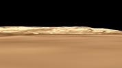
1998-03-13 |
Mars
|
Mars Global Surveyor (MGS)
|
Mars Orbiter Camera (MOC)
|
1356x9216x3 |
|
-
PIA00814:
-
Coprates Chasma
Full Resolution:
TIFF
(23.13 MB)
JPEG
(1.279 MB)
|
|
|
1997-08-22 |
Mars
|
Mars Global Surveyor (MGS)
|
Mars Orbiter Camera (MOC)
|
512x512x1 |

|
-
PIA00910:
-
MGS Approach Image - Syrtis Major Region
Full Resolution:
TIFF
(54.19 kB)
JPEG
(9.769 kB)
|
|
|
1997-08-22 |
Mars
|
Mars Global Surveyor (MGS)
|
Mars Orbiter Camera (MOC)
|
512x512x1 |
|
-
PIA00911:
-
MGS Approach Image - Chryse Planitia
Full Resolution:
TIFF
(52.54 kB)
JPEG
(9.599 kB)
|
|
|
1997-08-22 |
Mars
|
Mars Global Surveyor (MGS)
|
Mars Orbiter Camera (MOC)
|
512x512x1 |

|
-
PIA00912:
-
MGS Approach Image - Elysium Region
Full Resolution:
TIFF
(54.8 kB)
JPEG
(9.524 kB)
|
|
|
1997-09-10 |
Mars
|
Mars Global Surveyor (MGS)
|
Mars Orbiter Camera (MOC)
|
512x512x1 |
|
-
PIA00929:
-
MGS Approach Image - 172.4° W Longitude
Full Resolution:
TIFF
(42.96 kB)
JPEG
(8.111 kB)
|
|
|
1997-09-10 |
Mars
|
Mars Global Surveyor (MGS)
|
Mars Orbiter Camera (MOC)
|
512x512x1 |
|
-
PIA00930:
-
MGS Approach Image - 262.3° W Longitude
Full Resolution:
TIFF
(42.21 kB)
JPEG
(8.863 kB)
|
|
|
1997-09-10 |
Mars
|
Mars Global Surveyor (MGS)
|
Mars Orbiter Camera (MOC)
|
512x512x1 |

|
-
PIA00931:
-
MGS Approach Image - 352.2° W Longitude
Full Resolution:
TIFF
(44.39 kB)
JPEG
(9.87 kB)
|
|
|
1997-09-10 |
Mars
|
Mars Global Surveyor (MGS)
|
Mars Orbiter Camera (MOC)
|
512x512x1 |
|
-
PIA00932:
-
MGS Approach Image - 82.1° W Longitude
Full Resolution:
TIFF
(44.85 kB)
JPEG
(9.484 kB)
|
|
|
1997-09-10 |
Mars
|
Mars Global Surveyor (MGS)
|
Mars Orbiter Camera (MOC)
|
512x512x1 |
|
-
PIA00933:
-
MGS Approach Image - 217.4° W Longitude
Full Resolution:
TIFF
(45.74 kB)
JPEG
(9.268 kB)
|
|
|
1997-09-10 |
Mars
|
Mars Global Surveyor (MGS)
|
Mars Orbiter Camera (MOC)
|
512x512x1 |
|
-
PIA00934:
-
MGS Approach Image - 307.3° W Longitude
Full Resolution:
TIFF
(46.05 kB)
JPEG
(9.347 kB)
|
|
|
1997-09-10 |
Mars
|
Mars Global Surveyor (MGS)
|
Mars Orbiter Camera (MOC)
|
512x512x1 |
|
-
PIA00935:
-
MGS Approach Image - 37.2° W Longitude
Full Resolution:
TIFF
(47.3 kB)
JPEG
(9.643 kB)
|
|
|
1997-09-10 |
Mars
|
Mars Global Surveyor (MGS)
|
Mars Orbiter Camera (MOC)
|
512x512x1 |
|
-
PIA00936:
-
MGS Approach Image - 127.2° W Longitude
Full Resolution:
TIFF
(48.34 kB)
JPEG
(9.972 kB)
|
|
|
1997-09-24 |
Mars
|
Mars Global Surveyor (MGS)
|
Thermal Emission Spectrometer
|
554x553x3 |
|
-
PIA00937:
-
MGS Thermal Emission Spectrometer Image
Full Resolution:
TIFF
(90.26 kB)
JPEG
(80.87 kB)
|
|
|
1997-10-02 |
Mars
|
Mars Global Surveyor (MGS)
|
Mars Orbiter Camera (MOC)
|
2198x1328x1 |

|
-
PIA00941:
-
MGS Views of Labyrinthus Noctis
Full Resolution:
TIFF
(1.163 MB)
JPEG
(260.3 kB)
|
|
|
1997-10-02 |
Mars
|
Mars Global Surveyor (MGS)
|
Mars Orbiter Camera (MOC)
|
2637x1686x1 |
|
-
PIA00942:
-
MGS Views of Nirgal Vallis
Full Resolution:
TIFF
(2.573 MB)
JPEG
(722.7 kB)
|
|
|
1997-10-02 |
Mars
|
Mars Global Surveyor (MGS)
|
Mars Orbiter Camera (MOC)
|
630x504x1 |
|
-
PIA00943:
-
Subsection of Nirgal Vallis Image
Full Resolution:
TIFF
(325.3 kB)
JPEG
(101.6 kB)
|
|
|
1997-10-02 |
Mars
|
Mars Global Surveyor (MGS)
|
Mars Orbiter Camera (MOC)
|
1024x768x1 |
|
-
PIA00944:
-
Rotated Perspective View of Nirgal Vallis
Full Resolution:
TIFF
(625.1 kB)
JPEG
(193.6 kB)
|
|
|
1997-10-02 |
Mars
|
Mars Global Surveyor (MGS)
|
Mars Orbiter Camera (MOC)
|
1024x1024x1 |
|
-
PIA00945:
-
MGS Views of Labyrinthus Noctis
Full Resolution:
TIFF
(588.8 kB)
JPEG
(124.5 kB)
|
|
|
1997-10-13 |
Mars
|
Mars Global Surveyor (MGS)
|
Magnetometer
|
762x609x3 |
|
-
PIA00946:
-
Orientation and Magnitude of Mars' Magnetic Field
Full Resolution:
TIFF
(178.7 kB)
JPEG
(31.52 kB)
|
|
|
1997-10-13 |
Mars
|
Mars Global Surveyor (MGS)
|
Magnetometer
|
861x689x3 |

|
-
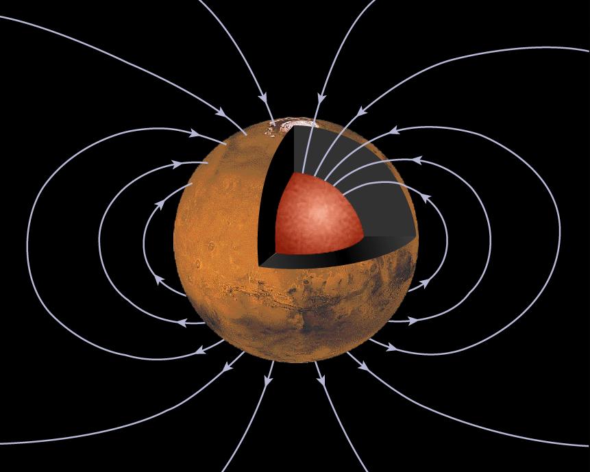
PIA00947:
-
Mars' Inner Core
Full Resolution:
TIFF
(232.6 kB)
JPEG
(51.04 kB)
|
|
|
1997-10-13 |
Mars
|
Mars Global Surveyor (MGS)
|
Magnetometer
|
905x723x3 |
|
-
PIA00948:
-
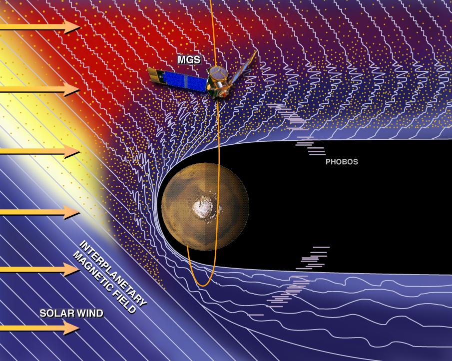
Mars and the Solar Wind
Full Resolution:
TIFF
(1.197 MB)
JPEG
(146.1 kB)
|
|
|
1997-10-13 |
Mars
|
Mars Global Surveyor (MGS)
|
Magnetometer
|
715x572x3 |
|
-
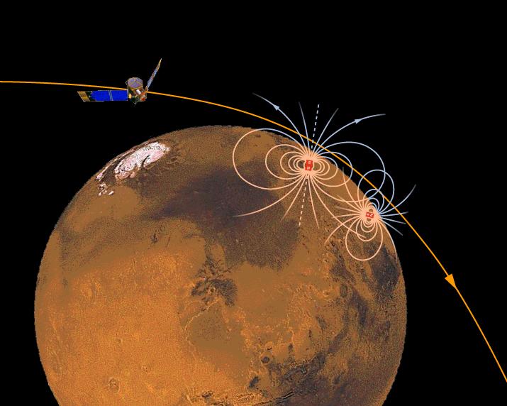
PIA00949:
-
Magnetic Sources in the Crust of Mars
Full Resolution:
TIFF
(360.8 kB)
JPEG
(50.93 kB)
|
|
|
1997-10-13 |
Mars
|
Mars Global Surveyor (MGS)
|
MOLA
|
2550x3300x3 |
|
-
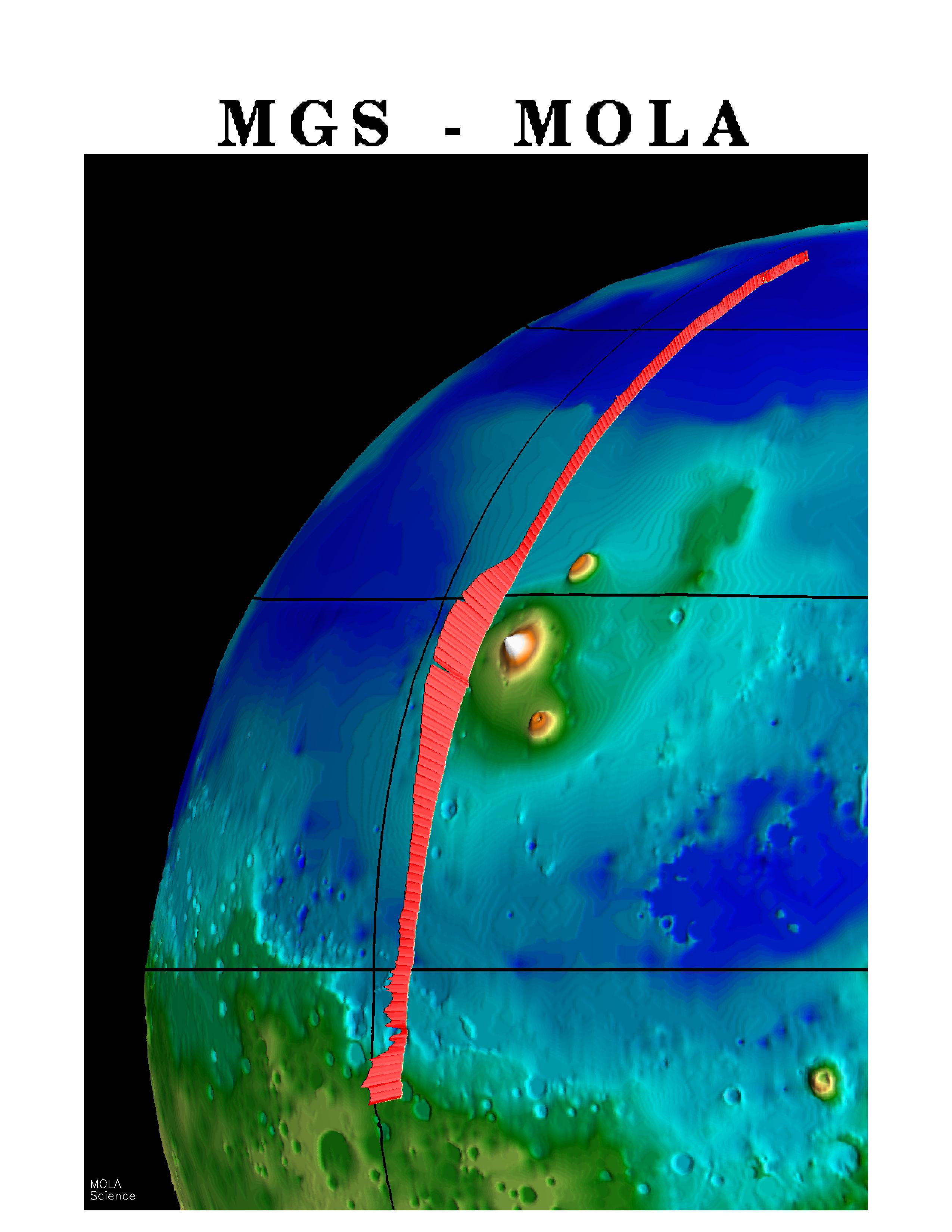
PIA00957:
-
MGS Mars Orbiter Laser (MOLA) Surface Topography of Northern Hemisphere
Full Resolution:
TIFF
(8.502 MB)
JPEG
(439.4 kB)
|
|
|
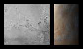
1997-10-13 |
Mars
|
Mars Global Surveyor (MGS)
|
MOLA
|
3300x1634x3 |

|
-
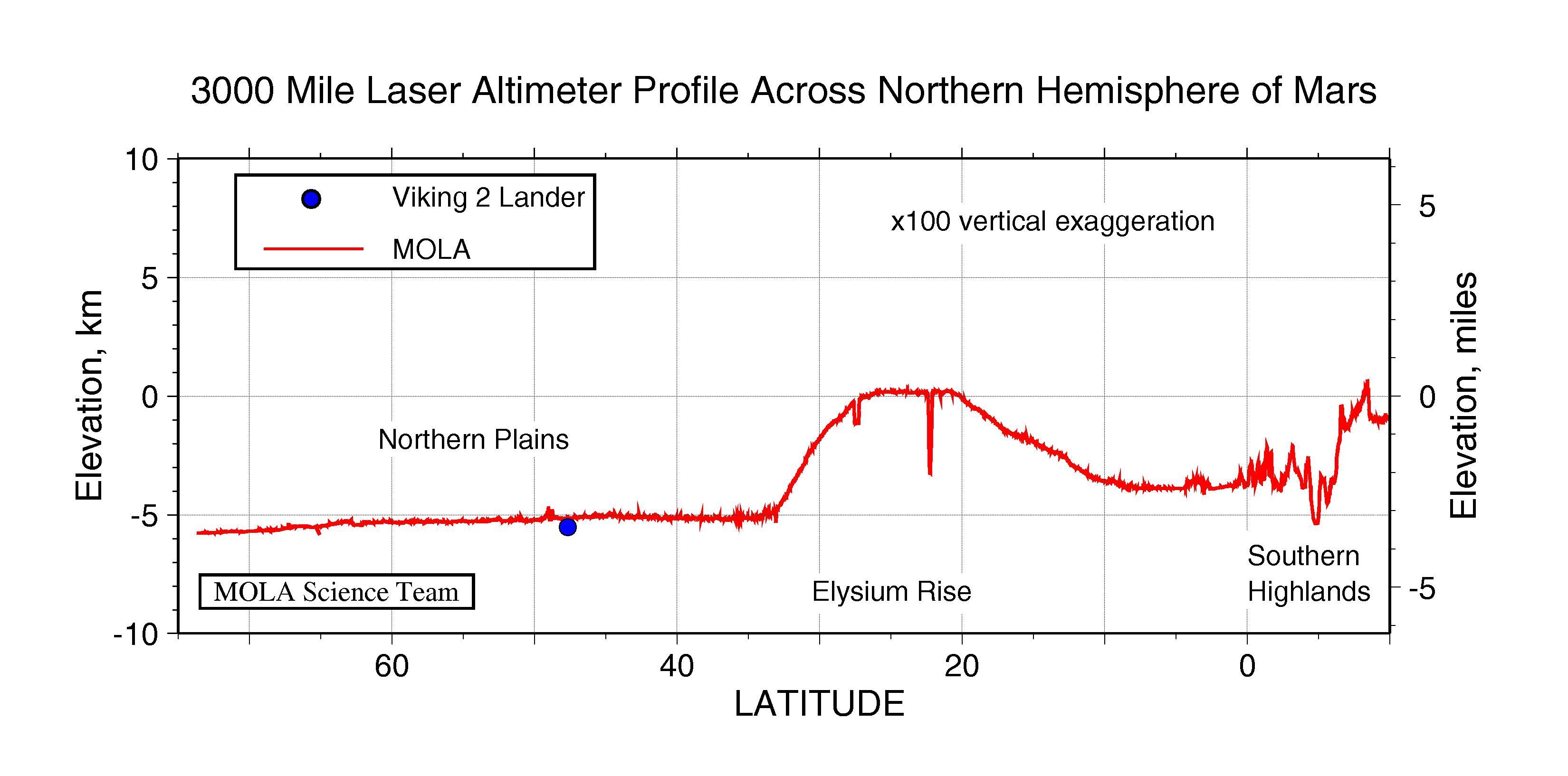
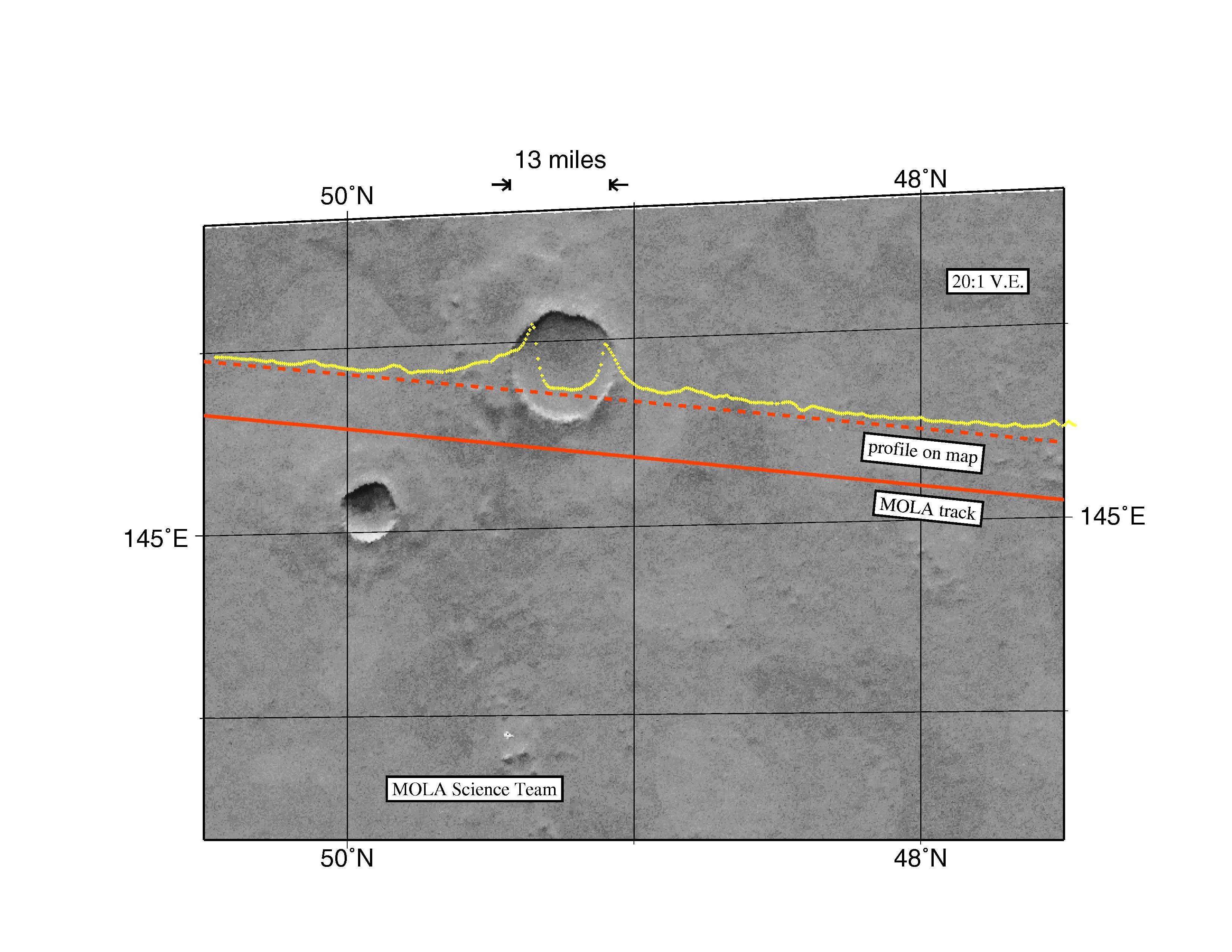
PIA00958:
-
3000 Mile Laser Altimeter Profile Across Northern Hemisphere of Mars
Full Resolution:
TIFF
(730.3 kB)
JPEG
(341 kB)
|
|
|
1997-10-13 |
Mars
|
Mars Global Surveyor (MGS)
|
MOLA
|
3300x2550x3 |
|
-
PIA00959:
-
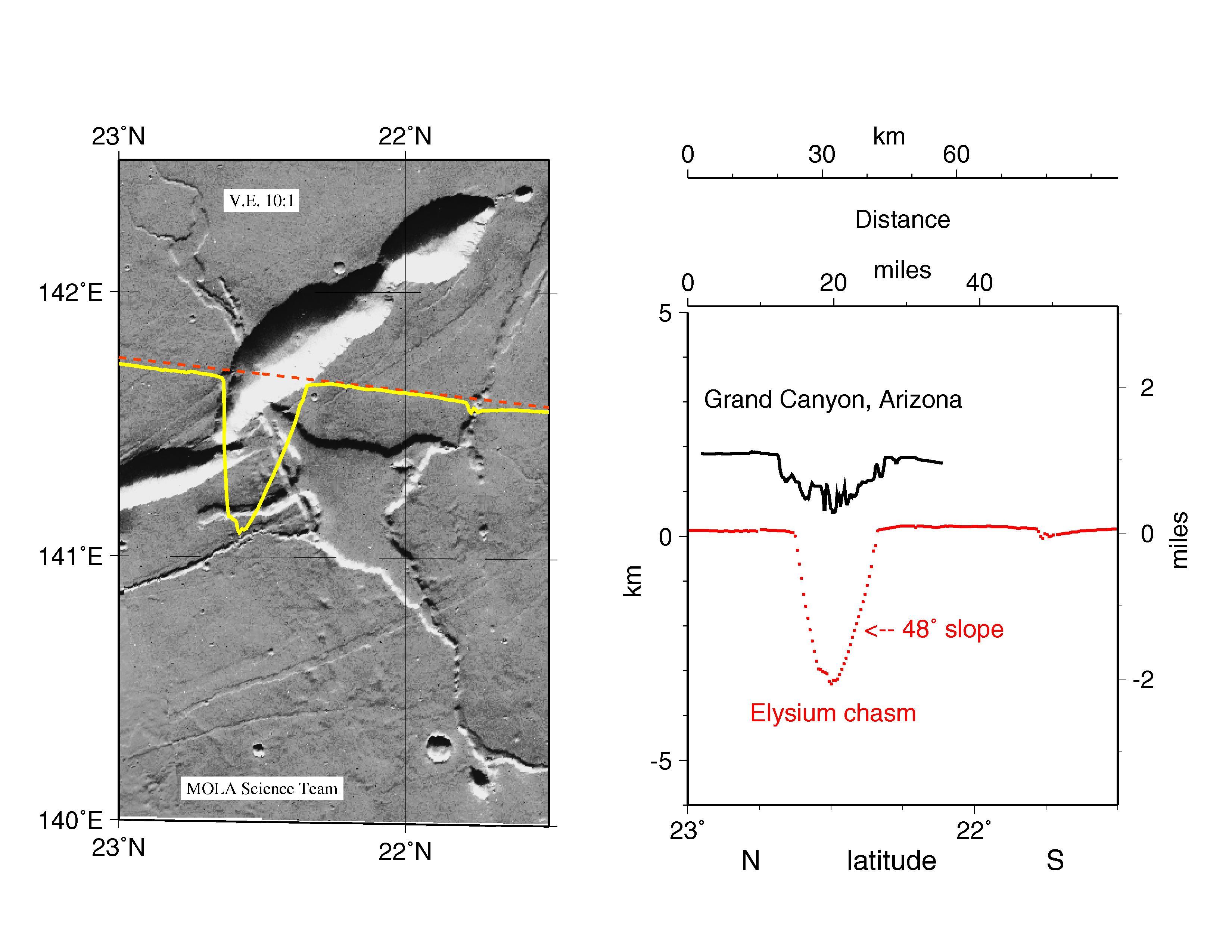
MGS Mars Orbiter Laser Altimeter Topographic Profile of Impact Crater
Full Resolution:
TIFF
(5.47 MB)
JPEG
(741 kB)
|
|
|
1997-10-13 |
Mars
|
Mars Global Surveyor (MGS)
|
MOLA
|
3300x2550x3 |
|
-
PIA00960:
-
MGS Mars Orbiter Laser Altimeter (MOLA) - Mars/Earth Relief Comparison
Full Resolution:
TIFF
(3.639 MB)
JPEG
(615.3 kB)
|
|
|
1997-10-15 |
Mars
|
Mars Global Surveyor (MGS)
|
Mars Orbiter Camera (MOC)
|
928x1552x3 |
|
-
PIA00991:
-
Valles Marineris
Full Resolution:
TIFF
(3.993 MB)
JPEG
(82.71 kB)
|
|
|
1997-10-15 |
Mars
|
Mars Global Surveyor (MGS)
|
Mars Orbiter Camera (MOC)
|
1023x608x3 |
|
-
PIA00992:
-
Valles Marineris
Full Resolution:
TIFF
(956.1 kB)
JPEG
(68.46 kB)
|
|
|
1998-04-23 |
Mars
|
Mars Global Surveyor (MGS)
|
Mars Orbiter Camera (MOC)
|
834x834x3 |

|
-
PIA00993:
-
Olympus Mons in Color
Full Resolution:
TIFF
(1.23 MB)
JPEG
(35.04 kB)
|
|
|
1997-11-10 |
Mars
|
Mars Global Surveyor (MGS)
|
MOLA
|
3300x2550x3 |
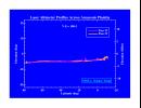
|
-
PIA01009:
-
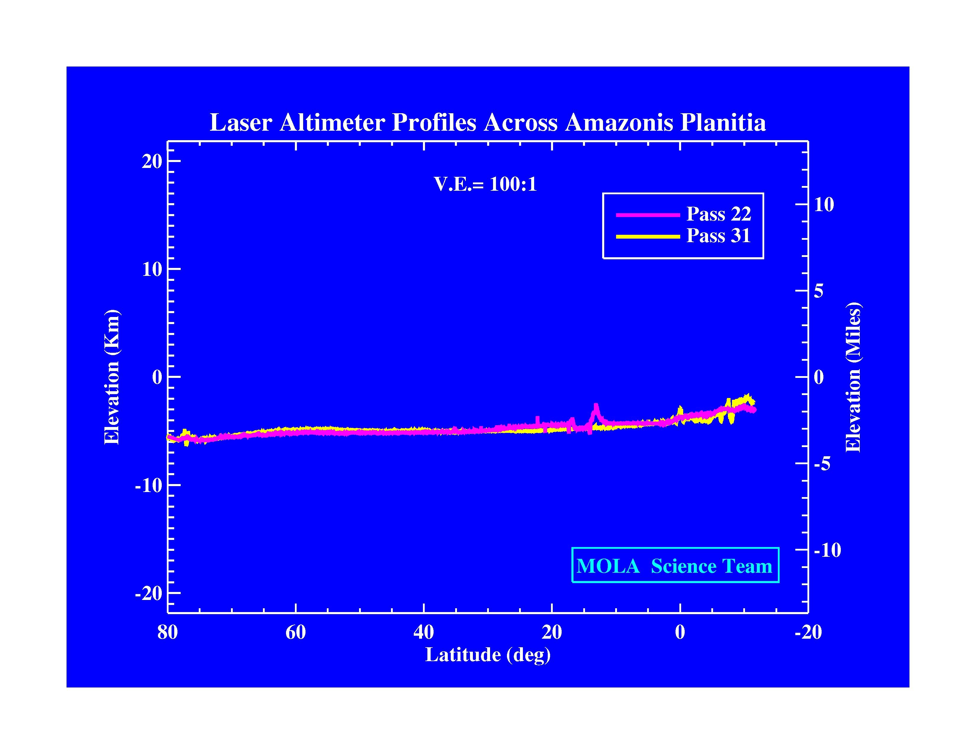
Laser Altimeter Profiles Across Amazonis Planitia
Full Resolution:
TIFF
(530.8 kB)
JPEG
(371.9 kB)
|
|
|
1997-11-10 |
Mars
|
Mars Global Surveyor (MGS)
|
MOLA
|
3300x2550x3 |
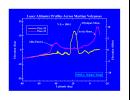
|
-
PIA01010:
-
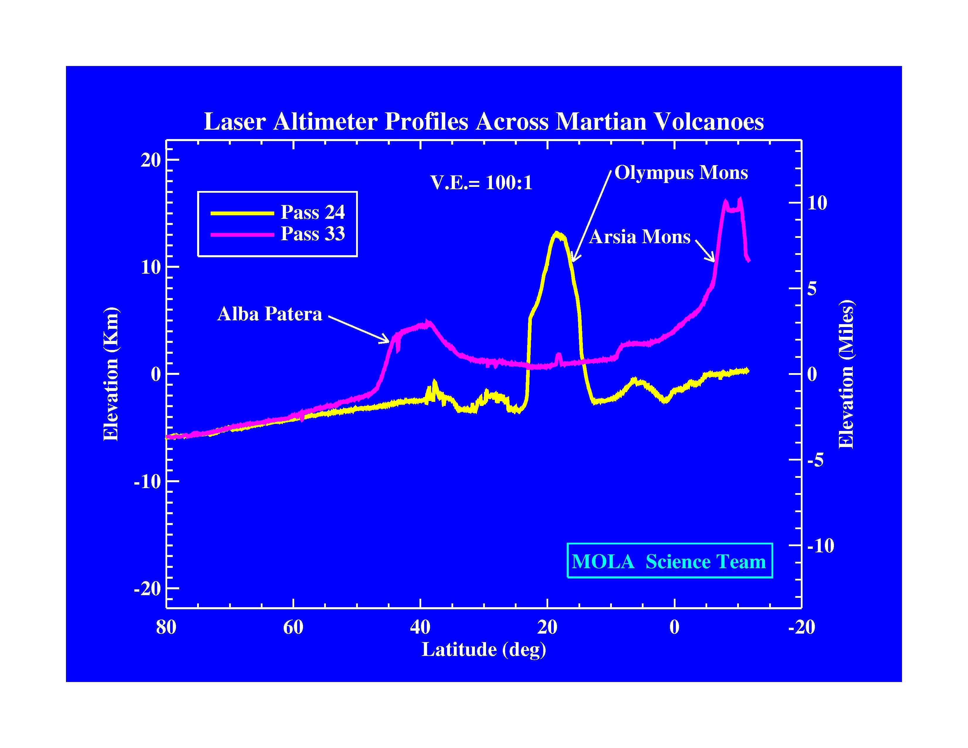
Laser Altimeter Profiles Across Martian Volcanoes
Full Resolution:
TIFF
(677.9 kB)
JPEG
(424.4 kB)
|
|
|
1997-11-10 |
Mars
|
Mars Global Surveyor (MGS)
|
MOLA
|
3300x2550x3 |
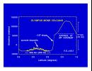
|
-
PIA01011:
-
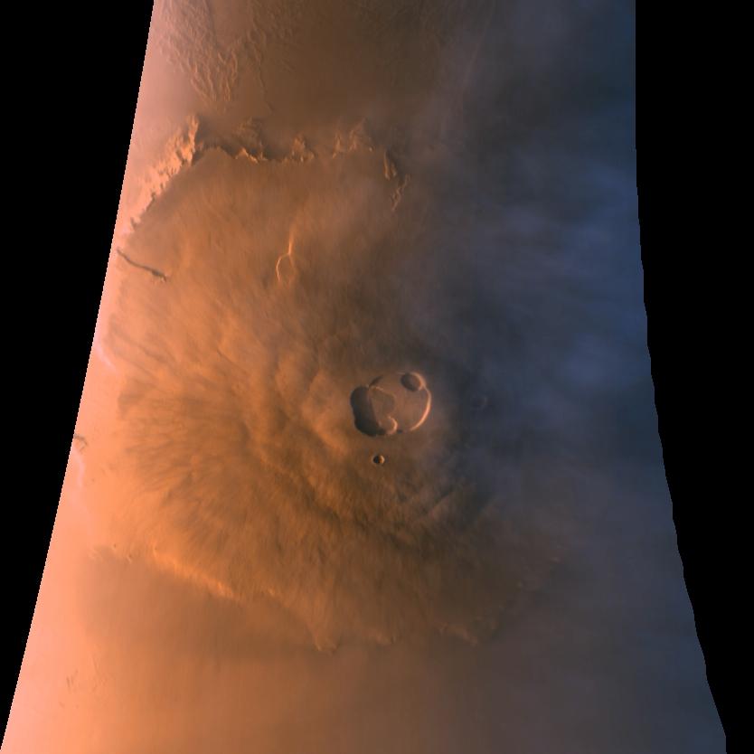
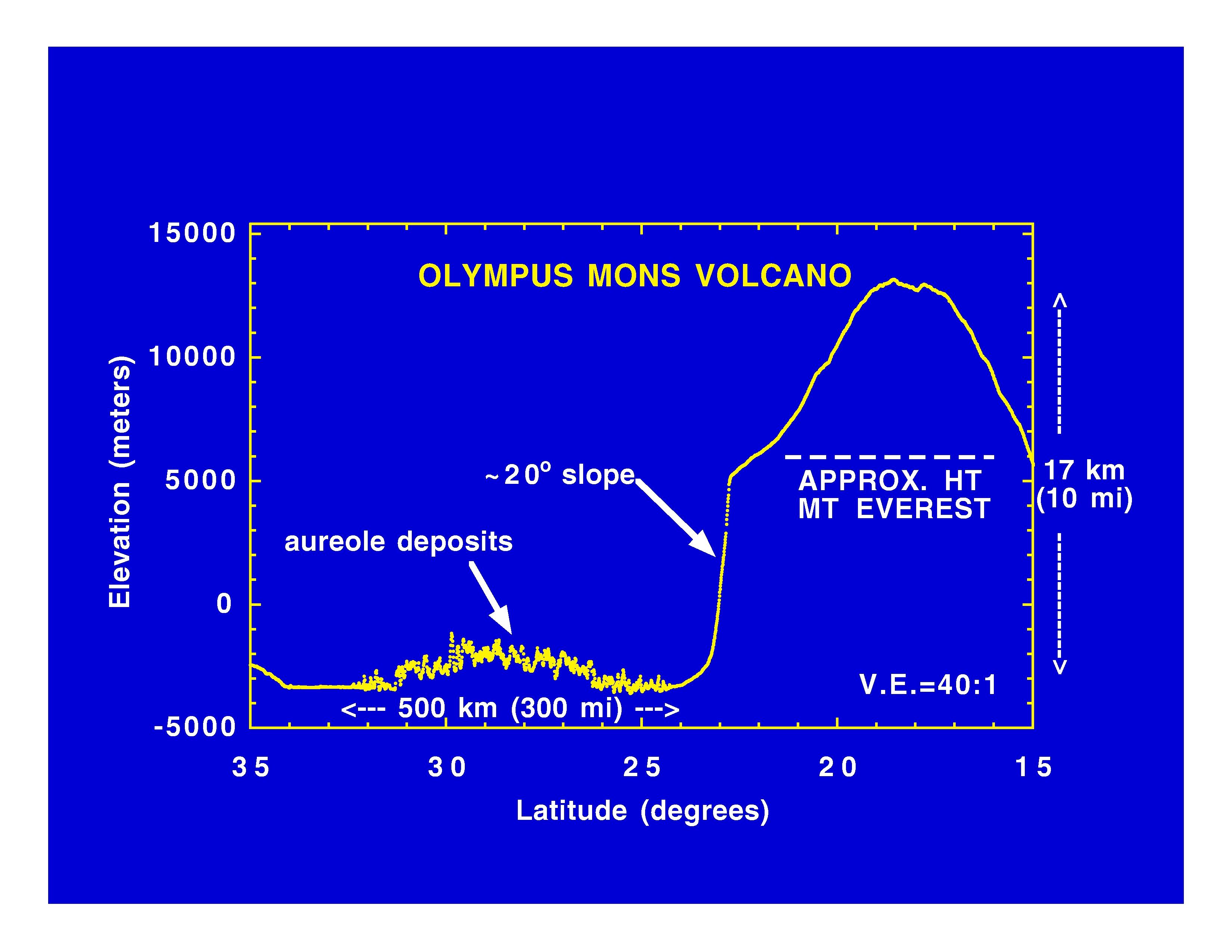
Olympus Mons Volcano
Full Resolution:
TIFF
(625.4 kB)
JPEG
(414.7 kB)
|
|
|
1997-11-10 |
Mars
|
Mars Global Surveyor (MGS)
|
MOLA
|
3300x2550x3 |
|
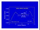
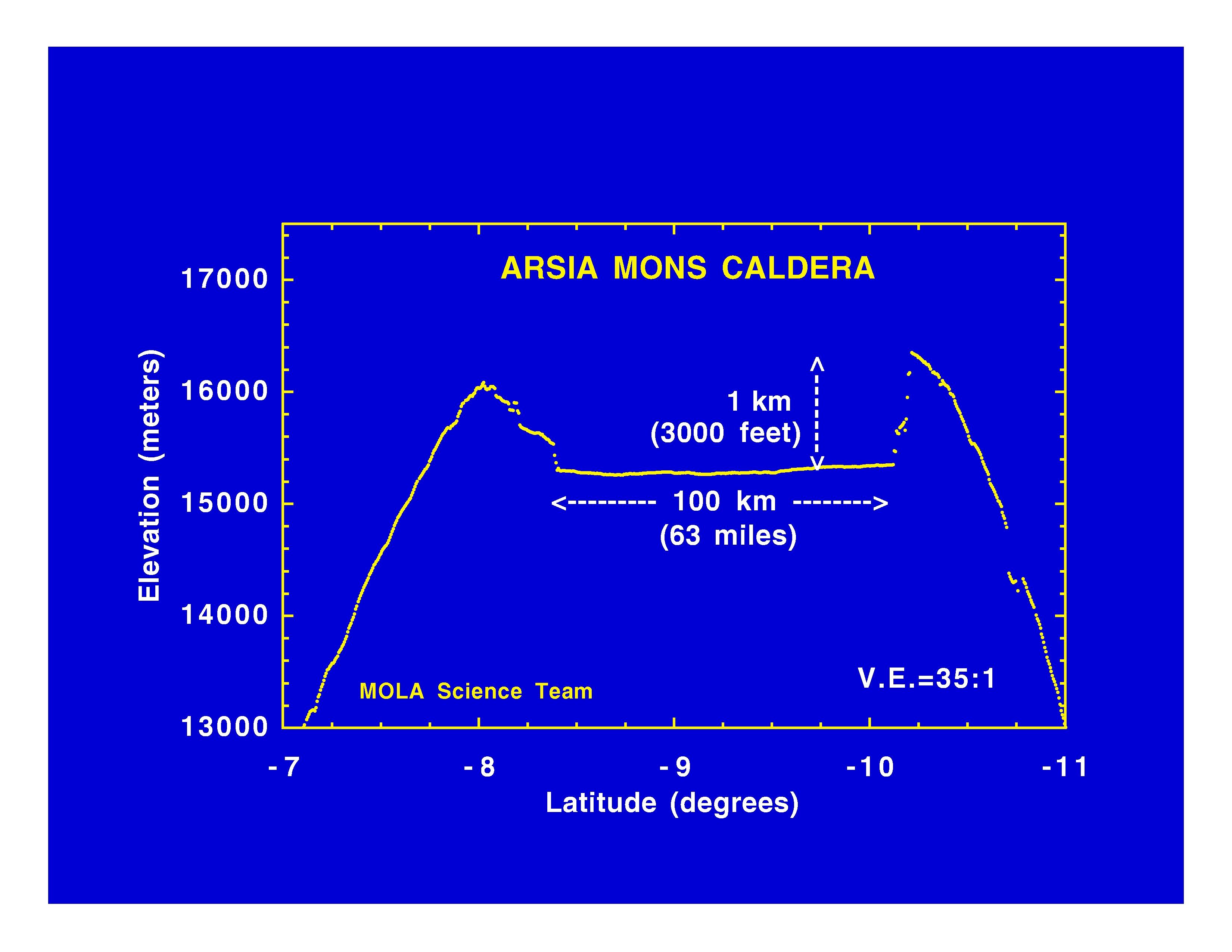
-
PIA01012:
-
Arsia Mons Caldera
Full Resolution:
TIFF
(534.1 kB)
JPEG
(365.8 kB)
|
|
|
1997-11-10 |
Mars
|
Mars Global Surveyor (MGS)
|
MOLA
|
3300x2550x3 |
|
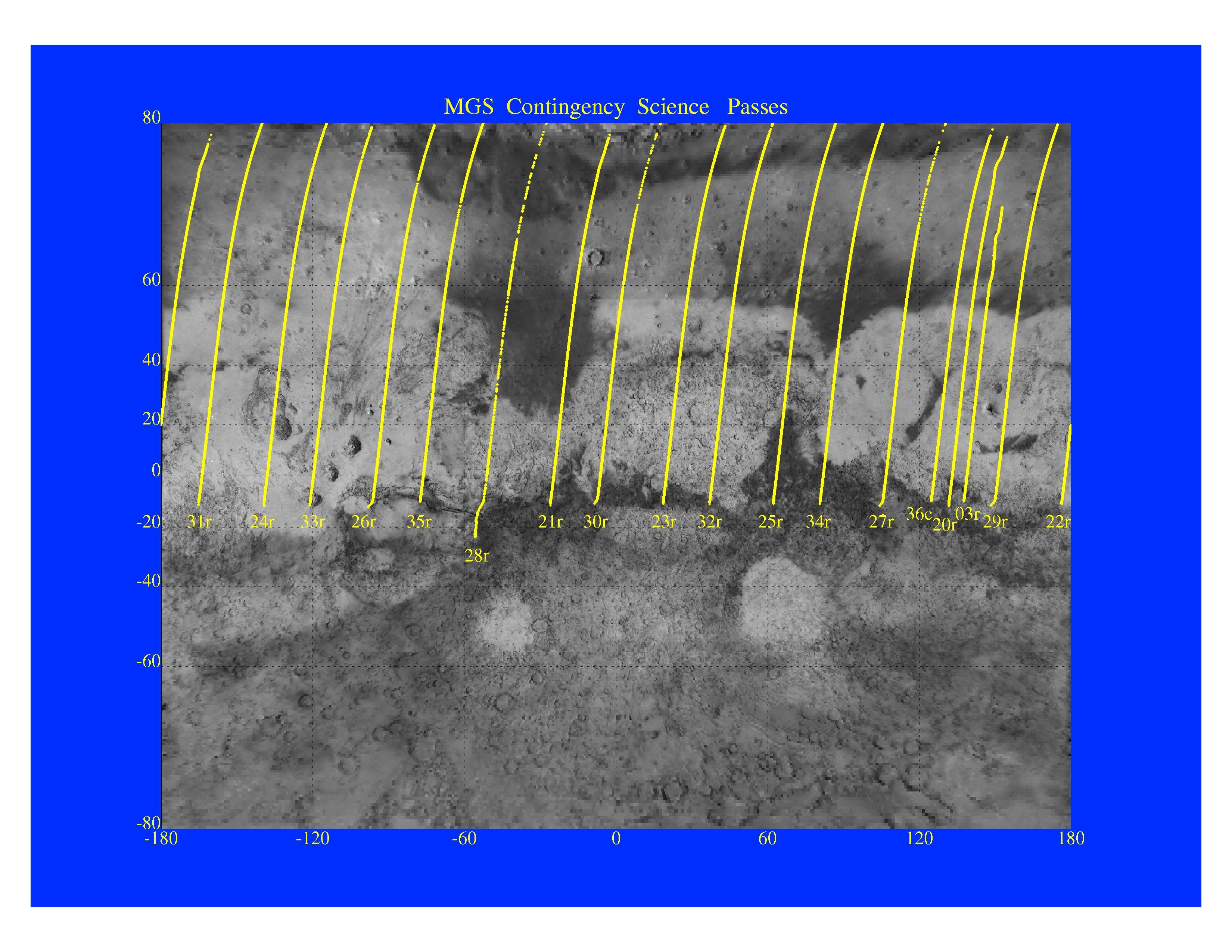
-
PIA01013:
-
MGS Contingency Science Passes
Full Resolution:
TIFF
(4.409 MB)
JPEG
(879.4 kB)
|
|
|
1997-11-10 |
Mars
|
Mars Global Surveyor (MGS)
|
MOLA
|
3300x2550x3 |
|
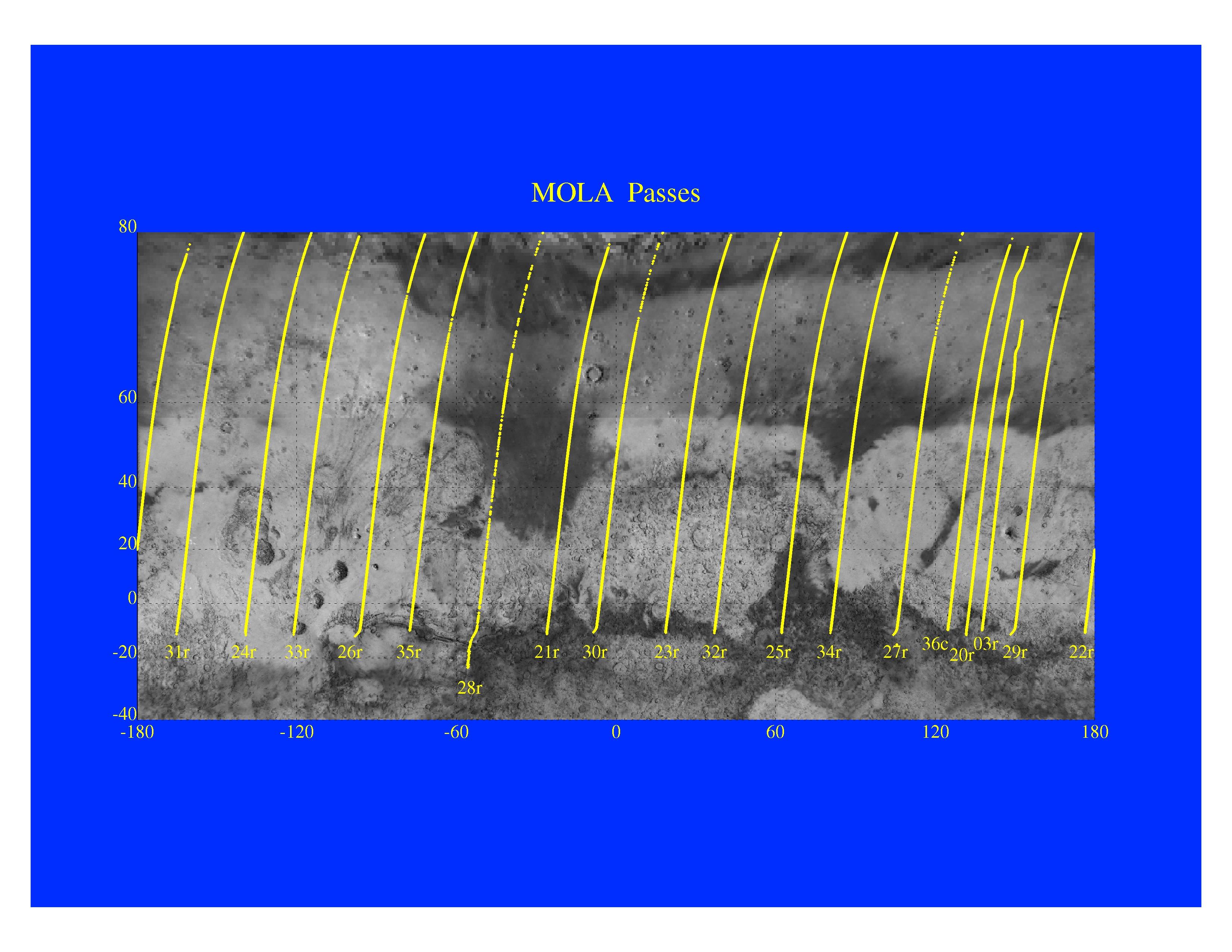
-
PIA01014:
-
Mars Orbiter Laser Altimeter Passes
Full Resolution:
TIFF
(3.582 MB)
JPEG
(723.3 kB)
|
|
|
1997-11-10 |
Mars
|
Mars Global Surveyor (MGS)
|
Magnetometer
|
996x746x3 |
|
-
PIA01015:
-
Martian Ionosphere
Full Resolution:
TIFF
(567.3 kB)
JPEG
(56.81 kB)
|
|
|
1997-11-10 |
Mars
|
Mars Global Surveyor (MGS)
|
Magnetometer
|
972x744x3 |
|
-
PIA01016:
-
Magnetic Anomalies on Mars
Full Resolution:
TIFF
(1.073 MB)
JPEG
(78.09 kB)
|
|
|
1997-11-10 |
Mars
|
Mars Global Surveyor (MGS)
|
Thermal Emission Spectrometer
|
1409x1091x3 |
|
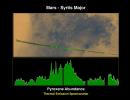
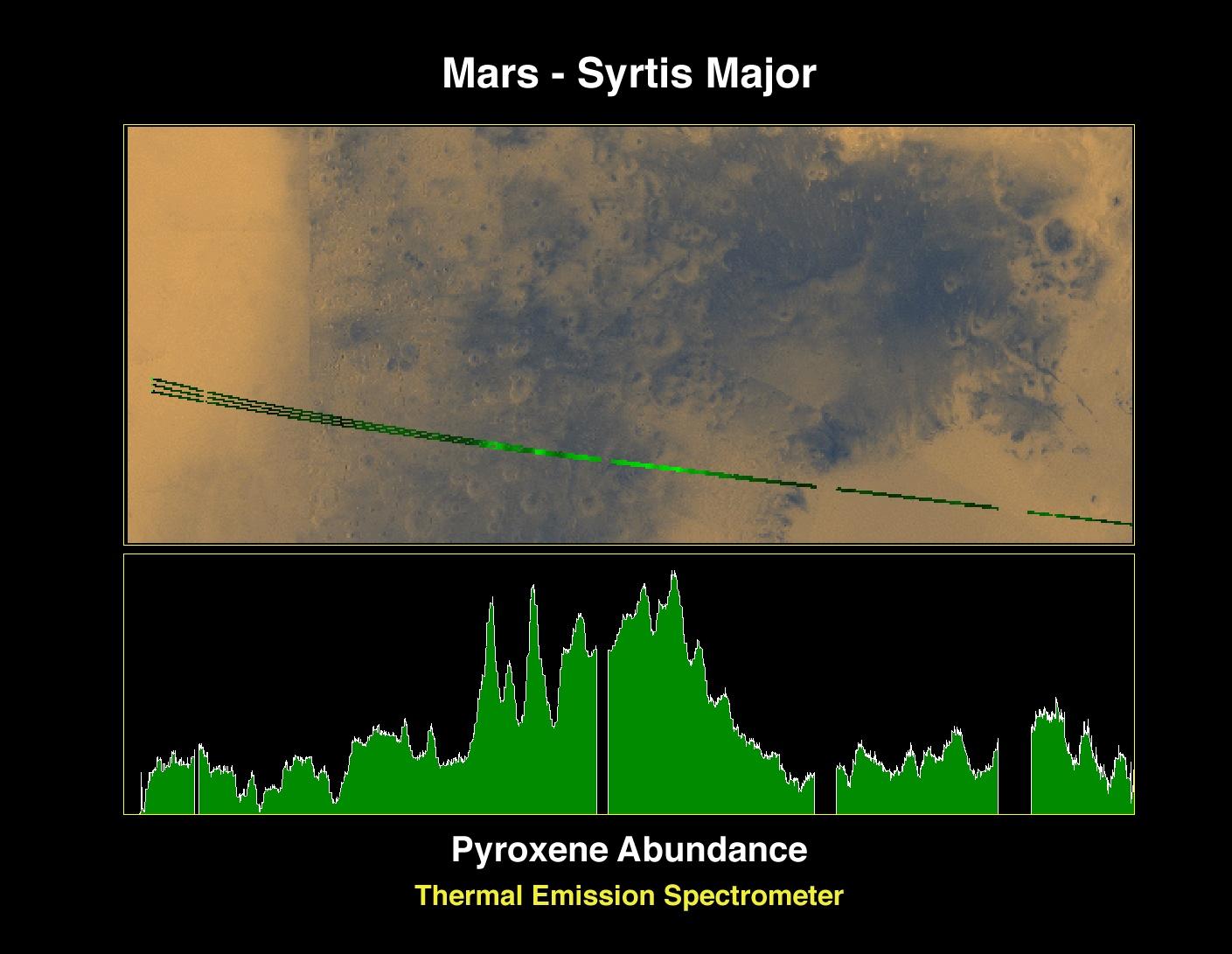
-
PIA01017:
-
Pyroxene at Syrtis Major
Full Resolution:
TIFF
(1.821 MB)
JPEG
(127.5 kB)
|
|
|
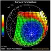
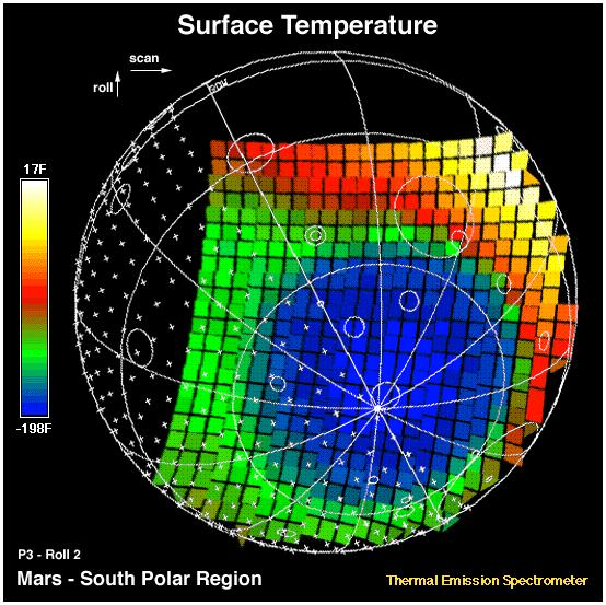
1997-11-10 |
Mars
|
Mars Global Surveyor (MGS)
|
Thermal Emission Spectrometer
|
1872x1224x3 |

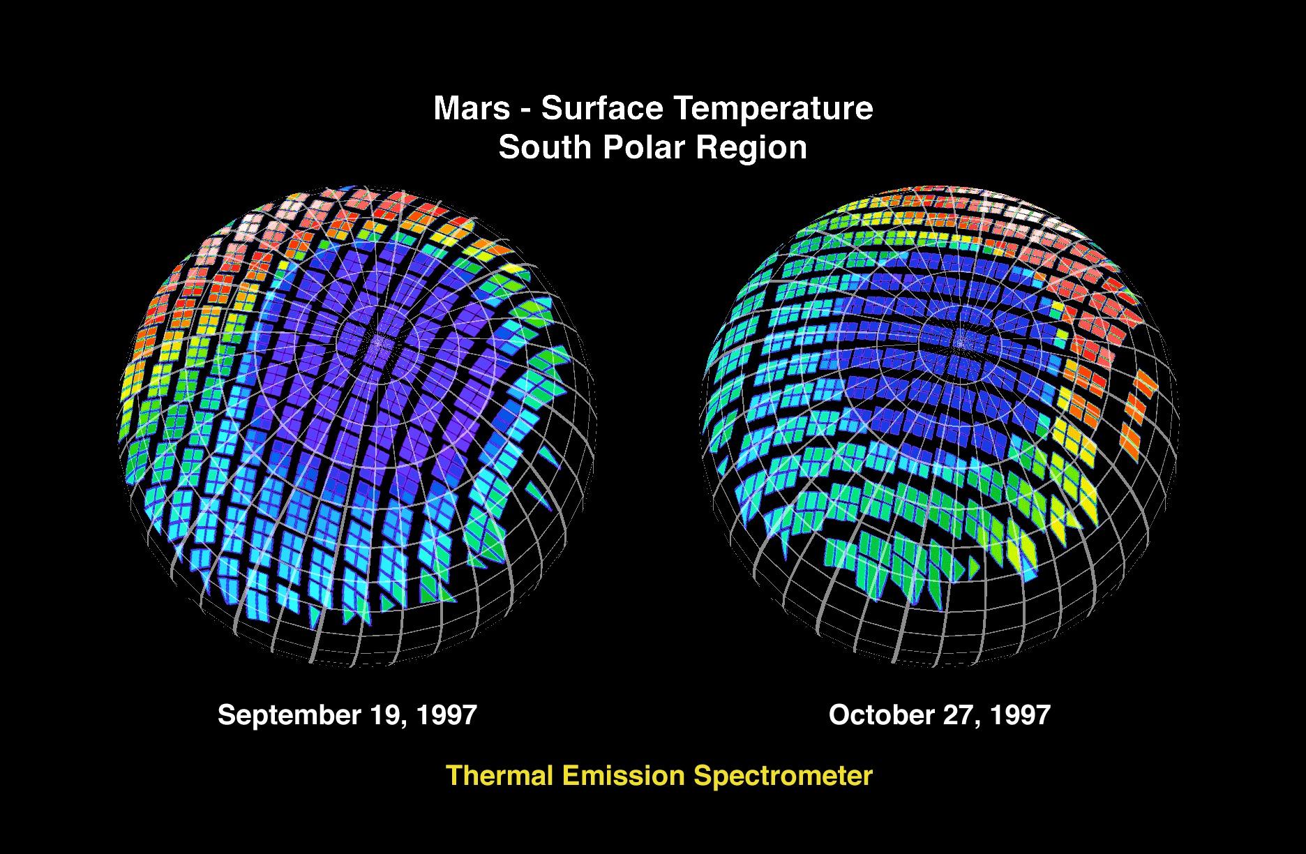
|
-
PIA01018:
-
Mars - Surface Temperature South Polar Region
Full Resolution:
TIFF
(2.253 MB)
JPEG
(360.5 kB)
|
|
|
1997-11-10 |
Mars
|
Mars Global Surveyor (MGS)
|
Thermal Emission Spectrometer
|
1400x1000x3 |
|
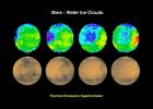
-
PIA01019:
-
Mars - Water Ice Clouds
Full Resolution:
TIFF
(1.695 MB)
JPEG
(147.2 kB)
|
|
|
1997-11-10 |
Mars
|
Mars Global Surveyor (MGS)
|
Thermal Emission Spectrometer
|
524x424x3 |
|
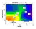
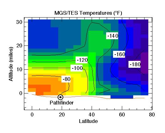
-
PIA01020:
-
MGS/TES Temperatures
Full Resolution:
TIFF
(17.04 kB)
JPEG
(32.43 kB)
|
|
|
1997-11-10 |
Mars
|
Mars Global Surveyor (MGS)
|
Mars Orbiter Camera (MOC)
|
2880x2880x1 |
|
-
PIA01021:
-
Western Tithonium Chasma/Ius Chasma, Valles Marineris
Full Resolution:
TIFF
(5.33 MB)
JPEG
(771.9 kB)
|
|
|
1997-11-10 |
Mars
|
Mars Global Surveyor (MGS)
|
Mars Orbiter Camera (MOC)
|
1024x1728x1 |
|
-
PIA01022:
-
Western Tithonium Chasma/Ius Chasma, Valles Marineris - High Resolution Image
Full Resolution:
TIFF
(1.698 MB)
JPEG
(268.3 kB)
|
|
|
1997-11-10 |
Mars
|
Mars Global Surveyor (MGS)
|
Mars Orbiter Camera (MOC)
|
1706x1280x1 |
|
-
PIA01023:
-
Western Tithonium Chasma/Ius Chasma, Valles Marineris - High Resolution Image
Full Resolution:
TIFF
(1.89 MB)
JPEG
(259.4 kB)
|
|
|
1997-11-10 |
Mars
|
Mars Global Surveyor (MGS)
|
Mars Orbiter Camera (MOC)
|
2023x996x1 |
|
-
PIA01024:
-
Valley and Surrounding Terrain Adjacent to Schiaparelli Crater
Full Resolution:
TIFF
(1.266 MB)
JPEG
(185.7 kB)
|
|
|
1997-11-10 |
Mars
|
Mars Global Surveyor (MGS)
|
Mars Orbiter Camera (MOC)
|
1024x2688x1 |
|
-
PIA01025:
-
Valley and Surrounding Terrain Adjacent to Schiaparelli Crater - High Resolution Image
Full Resolution:
TIFF
(1.424 MB)
JPEG
(197 kB)
|
|
|
1997-11-10 |
Mars
|
Mars Global Surveyor (MGS)
|
Mars Orbiter Camera (MOC)
|
2048x2048x1 |
|
-
PIA01026:
-
Valley and Surrounding Terrain Adjacent to Schiaparelli Crater - High Resolution Image
Full Resolution:
TIFF
(2.249 MB)
JPEG
(297.8 kB)
|
|
|
1997-11-10 |
Mars
|
Mars Global Surveyor (MGS)
|
Mars Orbiter Camera (MOC)
|
1640x900x1 |
|
-
PIA01027:
-
Complex Floor Deposits Within Western Ganges Chasma, Valles Marineris
Full Resolution:
TIFF
(1.183 MB)
JPEG
(230.3 kB)
|
|
|
1997-11-10 |
Mars
|
Mars Global Surveyor (MGS)
|
Mars Orbiter Camera (MOC)
|
512x1280x1 |
|
-
PIA01028:
-
Complex Floor Deposits Within Western Ganges Chasma, Valles Marineris - High Resolution Image
Full Resolution:
TIFF
(635.6 kB)
JPEG
(139 kB)
|
 Planetary Data System


