PDS logoPlanetary Data System
PDS Information
Find a Node - Use these links to navigate to any of the 8 publicly accessible PDS Nodes.

This bar indicates that you are within the PDS enterprise which includes 6 science discipline nodes and 2 support nodes which are overseen by the Project Management Office at NASA's Goddard Space Flight Center (GSFC). Each node is led by an expert in the subject discipline, supported by an advisory group of other practitioners of that discipline, and subject to selection and approval under a regular NASA Research Announcement.
Click here to return to the Photojournal Home Page Click here to view a list of Photojournal Image Galleries Photojournal_inner_header
Latest Images  |  Spacecraft & Technology  |  Animations  |  Space Images App  |  Feedback  |  Photojournal Search  

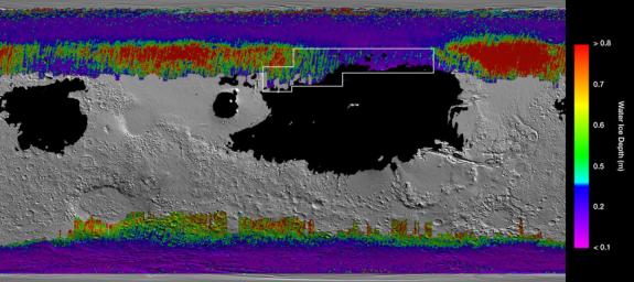
PIA23514: A Water Ice Map for Mars
 Target Name:  Mars
 Is a satellite of:  Sol (our sun)
 Mission:  2001 Mars Odyssey
Mars Reconnaissance Orbiter (MRO)
Mars Global Surveyor (MGS)
 Spacecraft:  2001 Mars Odyssey
Mars Reconnaissance Orbiter (MRO)
Mars Global Surveyor Orbiter
 Instrument:  MCS
THEMIS
 Product Size:  1614 x 720 pixels (w x h)
 Produced By:  Arizona State University
 Full-Res TIFF:  PIA23514.tif (2.369 MB)
 Full-Res JPEG:  PIA23514.jpg (311.5 kB)

Click on the image above to download a moderately sized image in JPEG format (possibly reduced in size from original)

Original Caption Released with Image:

This rainbow-colored map shows underground water ice on Mars. Cool colors represent less than one foot (30 centimeters) below the surface; warm colors are over two feet (60 centimeters) deep. Sprawling black zones on the map represent areas where a landing spacecraft would sink into fine dust. The outlined box represents the ideal region to send astronauts for them to be able to dig up water ice.

The map was created by combining data from multiple NASA orbiters, including the Mars Reconnaissance Orbiter and its Mars Climate Sounder instrument; Mars Odyssey and its Thermal Emission Imaging System; and the Mars Global Surveyor.

Image Credit:
NASA/JPL-Caltech/ASU

Image Addition Date:
2019-12-10