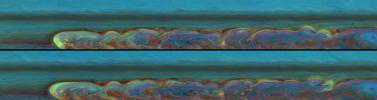
Two-Frame Animation
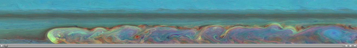
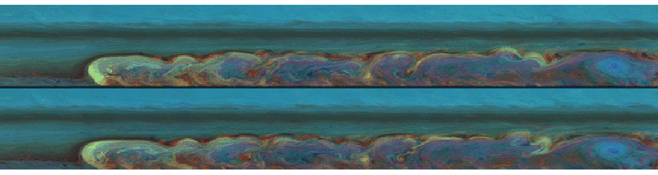
Click on the image for the animationThese false-color mosaics from NASA's Cassini spacecraft chronicle the changing appearance of the huge storm that developed from a small spot in Saturn's northern hemisphere. Here Cassini captures the changes over the short time span of one Saturn day.
Taken about 11 hours apart, these mosaics consist of 84 images each. The top mosaic was taken earlier than the bottom mosaic. Both mosaics were captured on Feb. 26, 2011, and each of the two batches of images was taken over about 4.5 hours.
This storm is the largest and longest lasting observed on Saturn by either NASA's Voyager or Cassini spacecraft. The storm's active phase ended in June 2011, but, as of Oct. 2011, the turbulent clouds have continued to linger in the atmosphere. As seen in these and other Cassini images, the storm encircles the planet whose circumference at these latitudes is 186,000 miles (300,000 kilometers). From north to south, it covers a distance of about 9,000 miles (15,000 kilometers), which is one-third of the way around Earth. It encompasses an area of 2 billion square miles (5 billion square kilometers), or eight times the surface area of Earth. This storm is about 500 times the area of the biggest of the southern hemisphere storms observed by Cassini (see PIA06197).
See PIA12825 and PIA14905 to watch the development of the storm and to learn more, such as how the head of the storm is drifting west.
At the head of storm the clouds at different heights crisscross each other. The red color shows deep clouds with no towering tops. These clouds, visible as bright red at the northern part of the storm, are very interesting to scientists who study wind shear, or the speeds of clouds at different altitudes. The wind shear is depicted in the different colors in these areas.
The blue oval area on the far right is a hole in the deep clouds of the atmosphere. Data from Cassini's composite infrared spectrometer show this blue area is a cold spot in the stratosphere. The blue color means it is high haze, but underneath there are no deep, or lower, clouds because there is no red color here. White and yellow colors at the head of the storm show these are high, thick clouds characteristic of convection and the solid anvils of towering thunder storms.
See PIA14903 and PIA14907 for similar, false-color mosaics taken about six months after this view.
A two-frame animation is also included here, scaled down from the full-size mosaics. The animation switches back and forth between the two mosaics allowing comparisons of the subtly changing cloud details.
Both mosaics cover an area ranging from about 30 degrees north latitude to 51 degrees north latitude. The views stretch from about 138 degrees west longitude on the left to 347 degrees west longitude on the right, passing through 360/0 degrees west longitude near the far right of the mosaics.
The images were taken with the Cassini spacecraft narrow-angle camera using a combination of spectral filters sensitive to wavelengths of near-infrared light. The images filtered at 889 nanometers are projected as blue. The images filtered at 727 nanometers are projected as green, and images filtered at 750 nanometers are projected as red.
The views were acquired at a distance of approximately 1.5 million miles (2.4 million kilometers) from Saturn and at a sun-Saturn-spacecraft angle (phase angle) of 62 degrees. Both the top and bottom images are simple cylindrical map projections, defined such that a square pixel subtends equal intervals of latitude and longitude. At higher latitudes, the pixel size in the north-south direction remains the same, but the pixel size (in terms of physical extent on the planet) in the east-west direction becomes smaller. The pixel size is set at the equator, where the distances along the sides are equal. The images have a pixel size of 11 miles (18 kilometers) at the equator.
The Cassini-Huygens mission is a cooperative project of NASA, the European Space Agency and the Italian Space Agency. NASA's Jet Propulsion Laboratory, a division of the California Institute of Technology in Pasadena manages the mission for NASA's Science Mission Directorate, Washington. The Cassini orbiter and its two onboard cameras were designed, developed and assembled at JPL. The imaging team is based at the Space Science Institute, Boulder, Colo.
For more information about the Cassini-Huygens mission, visit http://saturn.jpl.nasa.gov and the Cassini imaging team home page, http://ciclops.org.
 Planetary Data System


