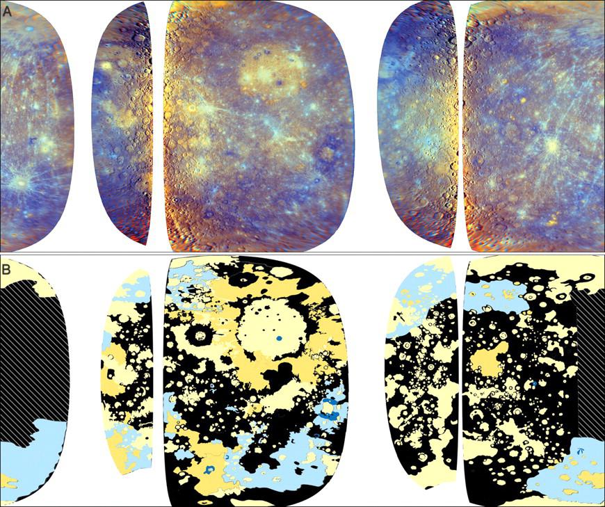
This image was recently featured in an article in Science magazine about the evolution of Mercury’s crust. The top mosaic (A) is an enhanced-color view (PIA12051) of the planet created from images taken through the WAC’s eleven color filters during MESSENGER’s first and second flybys of Mercury. White areas are those that MESSENGER has not yet observed. The bottom half of this image (B) is a map of major terrain types on Mercury. It was made by examining enhanced-color WAC mosaics (as shown at the top) that highlight color and compositional differences on the surface as well as higher-resolution Narrow Angle Camera (NAC) mosaics (PIA11767) that provide information about the surface texture and relationships among surface features.
On the geologic map, the pale yellow and darker yellow areas represent different types of smooth plains. The Caloris basin (PIA10359), for example, appears all in the pale yellow color, while the area around it is a darker yellow, indicating two different types of smooth plains in these neighboring areas. This global mapping study has indicated that smooth plains are widespread and cover about 40% of Mercury’s surface. Many large areas of smooth plains also show evidence for a volcanic origin, leading to the conclusion that volcanism may have been extensive in Mercury’s history. The light and dark blue colors highlight areas of the surface that have a lower reflectance and different composition than the smooth plains. The black areas on this map represent other kinds of terrain. The crosshatched areas were not included in the map because the high Sun angle during the flybys made them unsuitable for interpreting surface texture.
Credit: Figure 4 from Denevi et al., Science, 324, 613-618, 2009.
Date Acquired: January 14, 2008, and October 6, 2008
Instrument: Wide Angle Camera (WAC) of the Mercury Dual Imaging System (MDIS)
Scale: Mercury’s diameter is 4880 kilometers (3030 miles)
These images are from MESSENGER, a NASA Discovery mission to conduct the first orbital study of the innermost planet, Mercury. For information regarding the use of images, see the MESSENGER image use policy.
 Planetary Data System


