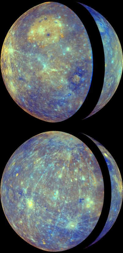
MESSENGER's two flybys of Mercury in 2008 have greatly increased the portion of the planet's surface that has been imaged by spacecraft, from approximately 45% coverage obtained by Mariner 10 to about 90% coverage following the second flyby. (Click here to see a coverage map.) This significant increase in imaging coverage is enabling global studies of Mercury's surface for the first time. MESSENGER team members recently published an article in the 1 May issue of Science magazine that utilizes this new global view to examine the evolution of Mercury's crust. This recent work was also featured in a NASA media teleconference, and the top image shown here was presented during that teleconference.
Both images are orthographic map projections of Mercury created with WAC enhanced-color images. The orthographic projection produces a view that has the perspective that one would see from deep space. The WAC enhanced color uses a statistical analysis of images from all 11 WAC filters to highlight subtle differences in the crustal rocks on Mercury's surface. (For other examples and discussion of enhanced color images, see previous releases of the departure view from Mercury flyby 2, Rudaki Plains, Thākur crater and Caloris basin.) The top view uses images from Mercury flyby 1, with the thin crescent of Mercury imaged during approach forming the right portion of the globe and the fuller departure view showing Caloris basin forming the left side and majority of the view. The black strip between the approach and departure images is a portion of Mercury's surface not viewed by MESSENGER during the flybys. Similarly, the approach and departure images obtained during Mercury flyby 2 yielded the bottom view. The top and bottom projections are centered on 180° and 0° longitude, respectively.
Date Acquired: January 14, 2008, and October 6, 2008
Instrument: Wide Angle Camera (WAC) of the Mercury Dual Imaging System (MDIS)
Scale: Mercury’s diameter is 4880 kilometers (3030 miles)
These images are from MESSENGER, a NASA Discovery mission to conduct the first orbital study of the innermost planet, Mercury. For information regarding the use of images, see the MESSENGER image use policy.
 Planetary Data System


