Click on an image for detailed information
Click on a column heading to sort in ascending or descending order

My
List |
Addition Date
|
Target
|
Mission
|
Instrument
|
Size
|

|
2021-03-30 |
Mars
|
Mars Science Laboratory (MSL)
|
Mastcam
|
29163x7195x3 |
|
-
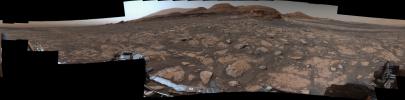
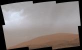
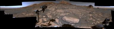
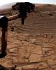
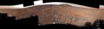
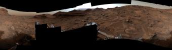
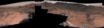
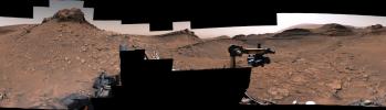
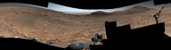
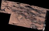
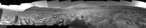
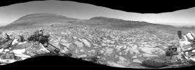
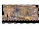
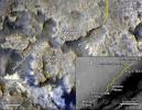
PIA24269:
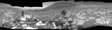
Curiosity's 360-Degree View Approaching Mont Mercou
Full Resolution:
TIFF
(451.8 MB)
JPEG
(36.07 MB)
|
|
|
2021-03-30 |
Mars
|
Mars Science Laboratory (MSL)
|
MAHLI
Mastcam
|
21969x14501x3 |
|
-
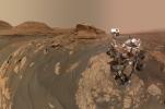
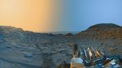
PIA24543:
-
Curiosity's Selfie at Mont Mercou
Full Resolution:
TIFF
(654 MB)
JPEG
(21.21 MB)
|
|
|
2021-04-05 |
Mars
|
Mars Science Laboratory (MSL)
|
Mastcam
|
7254x2370x3 |

|
-
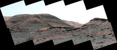
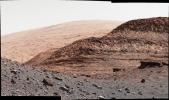
PIA24544:
-
Rafael Navarro Mountain
Full Resolution:
TIFF
(39.96 MB)
JPEG
(2.719 MB)
|
|
|
2021-05-10 |
Mars
|
Mars Science Laboratory (MSL)
|
Mastcam
|
29163x7891x3 |
|
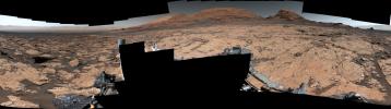
-
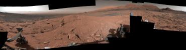
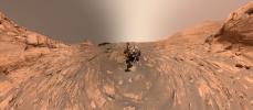
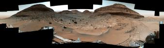
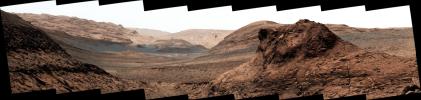
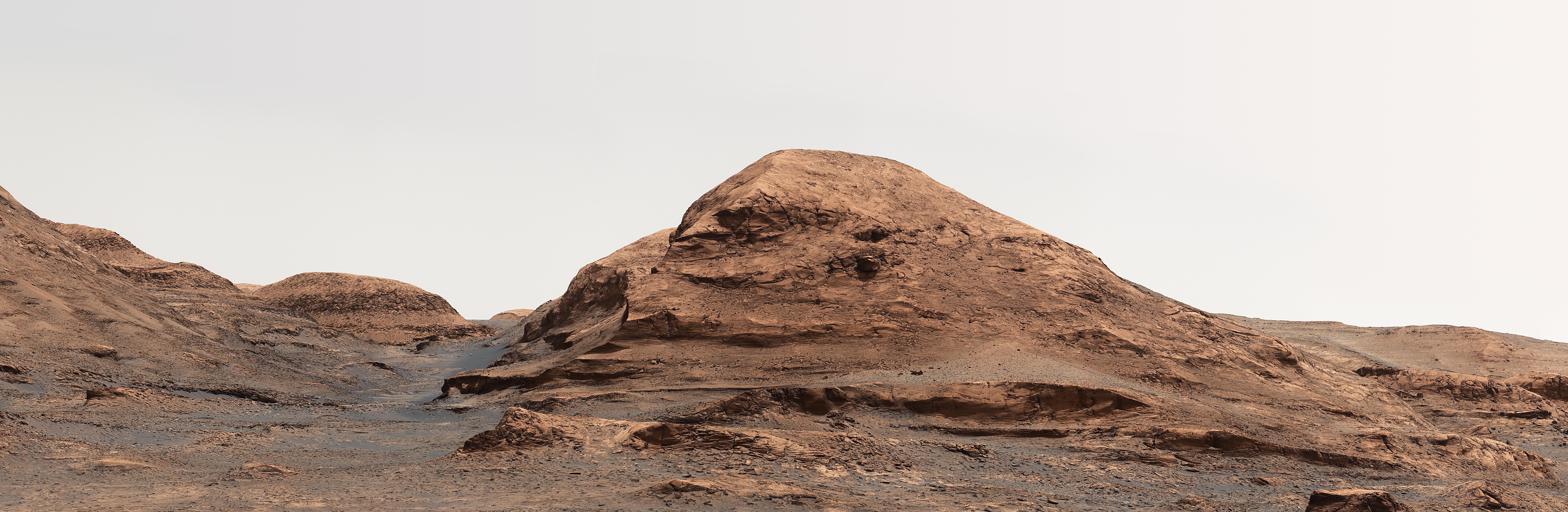
PIA24626:
Curiosity's 360-degree View Atop Mont Mercou
Full Resolution:
TIFF
(459.3 MB)
JPEG
(31.54 MB)
|
|
|
2021-05-28 |
Mars
|
Mars Science Laboratory (MSL)
|
Mastcam
|
7000x3000x3 |
|
-
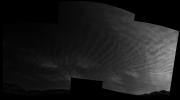
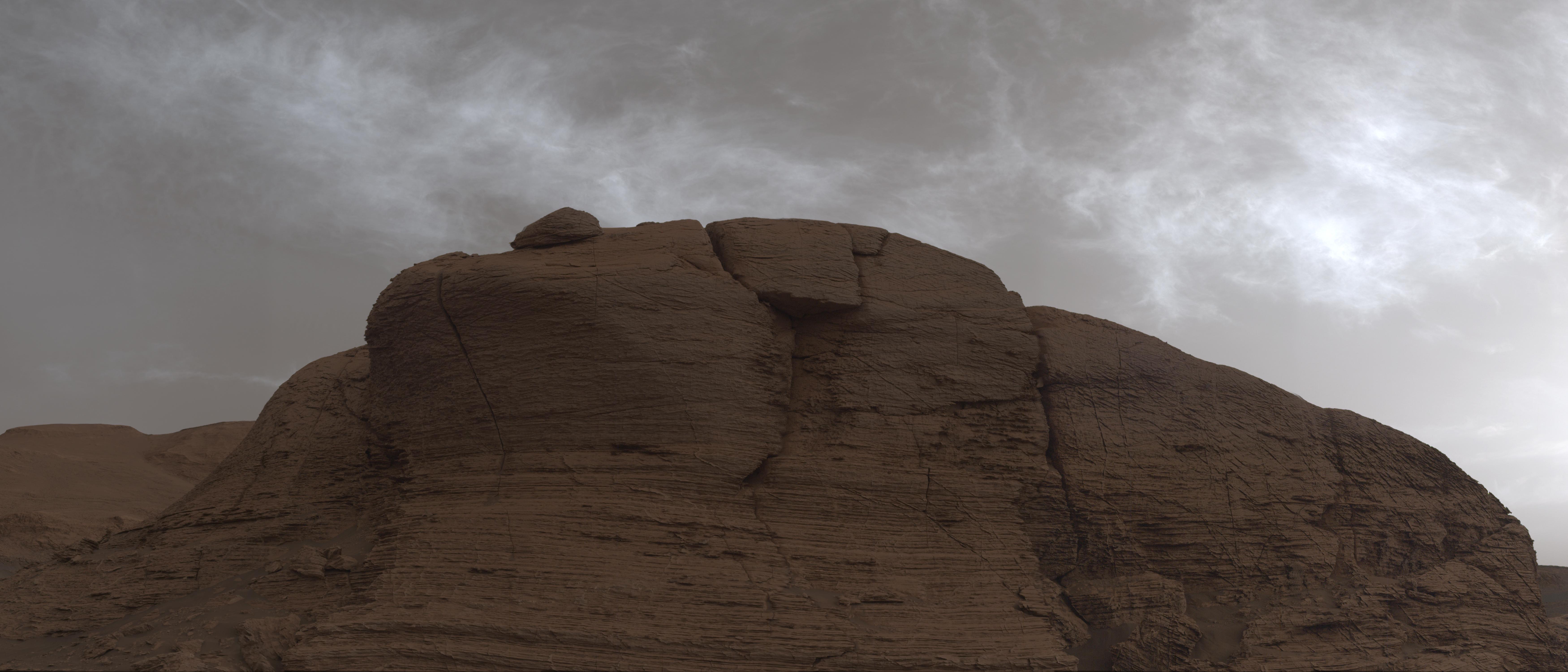
PIA24622:
-
Curiosity Spots Clouds Over Mont Mercou
Full Resolution:
TIFF
(40.61 MB)
JPEG
(1.304 MB)
|
|
|
2021-05-28 |
Mars
|
Mars Science Laboratory (MSL)
|
Mastcam
|
1900x1160x3 |
|
-
PIA24661:
-
Curiosity GIF Shows Drifting Clouds Over Mars' Mount Sharp
Full Resolution:
TIFF
(3.821 MB)
JPEG
(88.01 kB)
|
|
|
2021-05-28 |
Mars
|
Mars Science Laboratory (MSL)
|
Navcam (MSL)
|
2526x1401x3 |
|
-
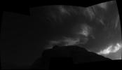
PIA24645:
-
Curiosity Navigation Cameras Spot Twilight Clouds on Sol 3075
Full Resolution:
TIFF
(1.471 MB)
JPEG
(90.56 kB)
|
|
|
2021-05-28 |
Mars
|
Mars Science Laboratory (MSL)
|
Navcam (MSL)
|
2514x1448x3 |
|
-
PIA24646:
-
Curiosity Navigation Cameras Spot Twilight Clouds on Sol 3072
Full Resolution:
TIFF
(1.252 MB)
JPEG
(79.95 kB)
|
|
|
2021-05-28 |
Mars
|
Mars Science Laboratory (MSL)
|
Mastcam
|
5077x1390x3 |
|
-
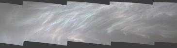
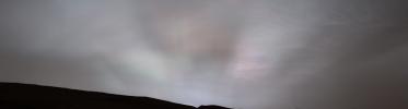
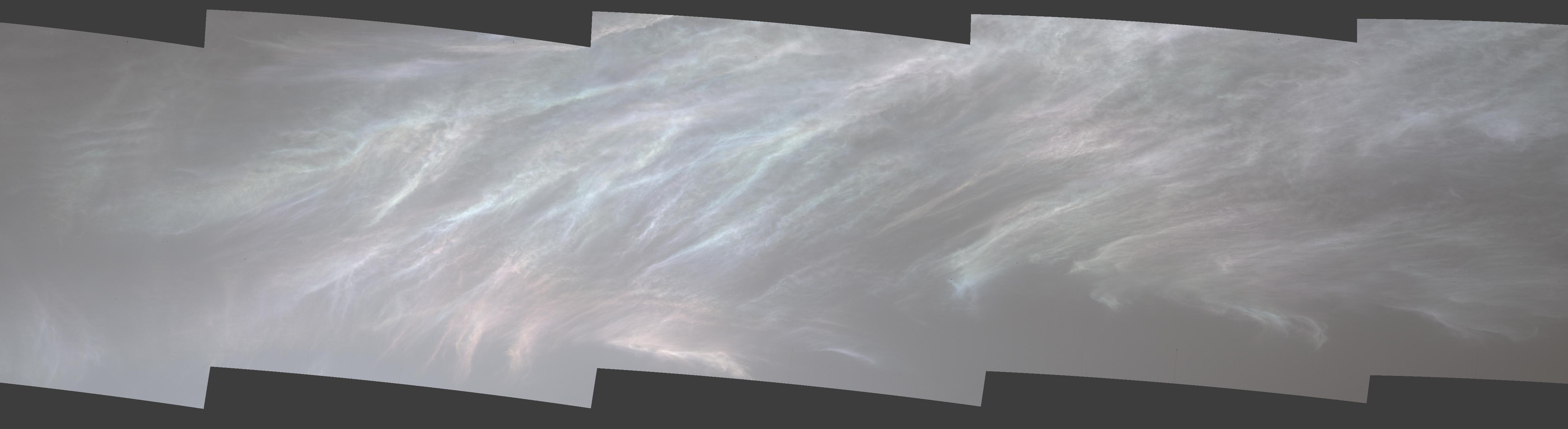
PIA24662:
Curiosity Spots Iridescent Mother of Pearl Clouds
Full Resolution:
TIFF
(11.27 MB)
JPEG
(265.2 kB)
|
|
|
2021-08-17 |
Mars
|
Mars Science Laboratory (MSL)
|
Mastcam
|
29061x7568x3 |
|
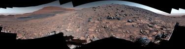
-
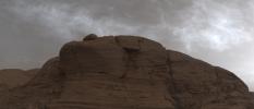
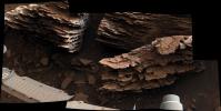
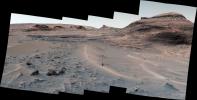
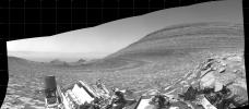
PIA24643:
Curiosity Looks Uphill Past Rafael Navarro Mountain
Full Resolution:
TIFF
(464.9 MB)
JPEG
(35.85 MB)
|
|
|
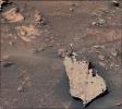
2021-08-17 |
Mars
|
Mars Science Laboratory (MSL)
|
MAHLI
|
3000x3150x3 |
|
-
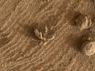
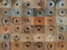
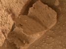
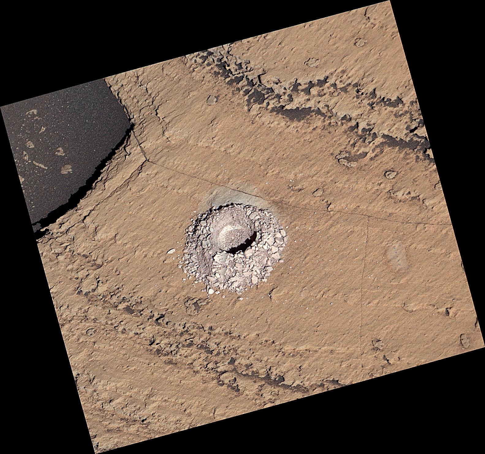
PIA24764:
-
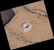
Curiosity's 32 Drill Holes
Full Resolution:
TIFF
(28.36 MB)
JPEG
(2.084 MB)
|
|
|
2021-11-23 |
Mars
|
Mars Science Laboratory (MSL)
|
Navcam (MSL)
|
1932x1087x3 |

|
-
PIA24937:
-
A Picture Postcard From Curiosity's Navcams
Full Resolution:
TIFF
(5.197 MB)
JPEG
(198.6 kB)
|
|
|
2021-11-29 |
Mars
|
Mars Science Laboratory (MSL)
|
MAHLI
|
25764x11268x3 |
|
-
PIA24938:
-
Two Versions of a Curiosity Selfie: Narrow and Wide
Full Resolution:
TIFF
(590.9 MB)
JPEG
(16.53 MB)
|
|
|
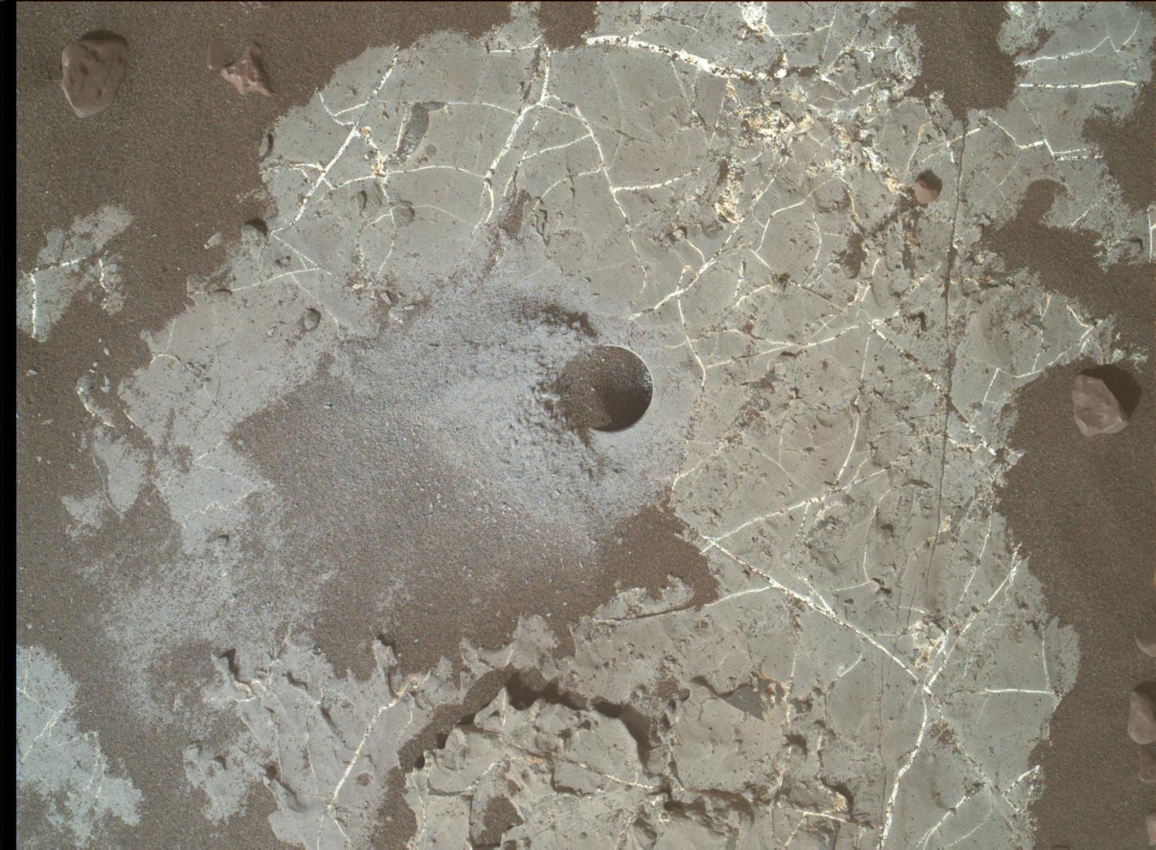
2022-01-18 |
Mars
|
Mars Science Laboratory (MSL)
|
MAHLI
|
1632x1200x3 |
|
-
PIA25045:
-
Highfield Drill Hole
Full Resolution:
TIFF
(5.877 MB)
JPEG
(367.9 kB)
|
|
|
2022-01-25 |
Mars
|
Mars Science Laboratory (MSL)
|
Mastcam
|
4550x5688x3 |
|
-
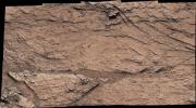
PIA25046:
-
Curiosity Mastcam's View of Edinburgh
Full Resolution:
TIFF
(72.01 MB)
JPEG
(4.517 MB)
|
|
|
2022-03-01 |
Mars
|
Mars Science Laboratory (MSL)
|
MAHLI
|
1561x1167x3 |
|
-
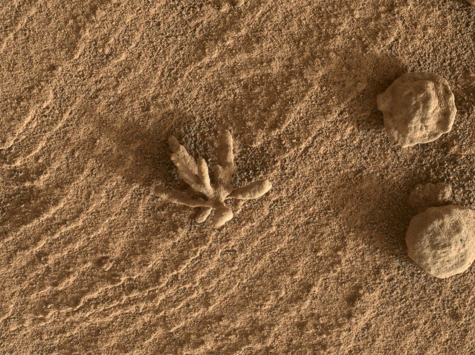
PIA25077:
-
Curiosity Finds a Martian Flower
Full Resolution:
TIFF
(5.467 MB)
JPEG
(495.8 kB)
|
|
|
2022-04-06 |
Mars
|
Mars Science Laboratory (MSL)
|
Hazcam (MSL)
|
1024x768x1 |
|
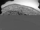
-
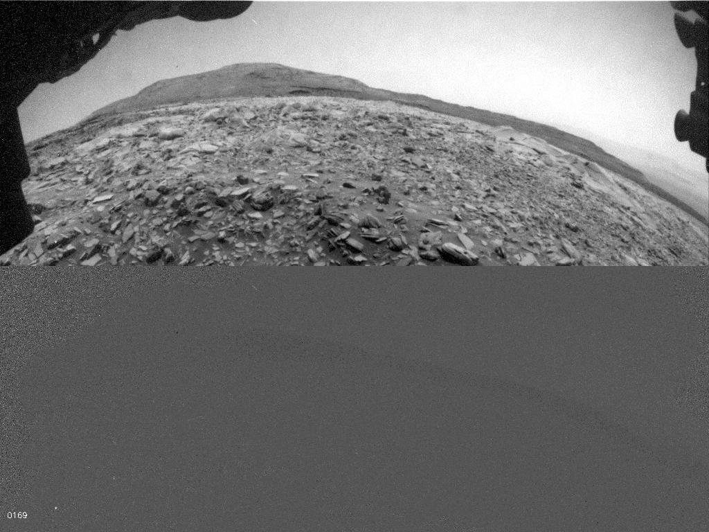
PIA25177:
-
Curiosity's Hazcam Catches a Dusty Wind Gust
Full Resolution:
TIFF
(770.5 kB)
JPEG
(123.6 kB)
|
|
|
2022-04-07 |
Mars
|
Mars Science Laboratory (MSL)
|
Mastcam
|
5833x3324x3 |
|
-
PIA25175:
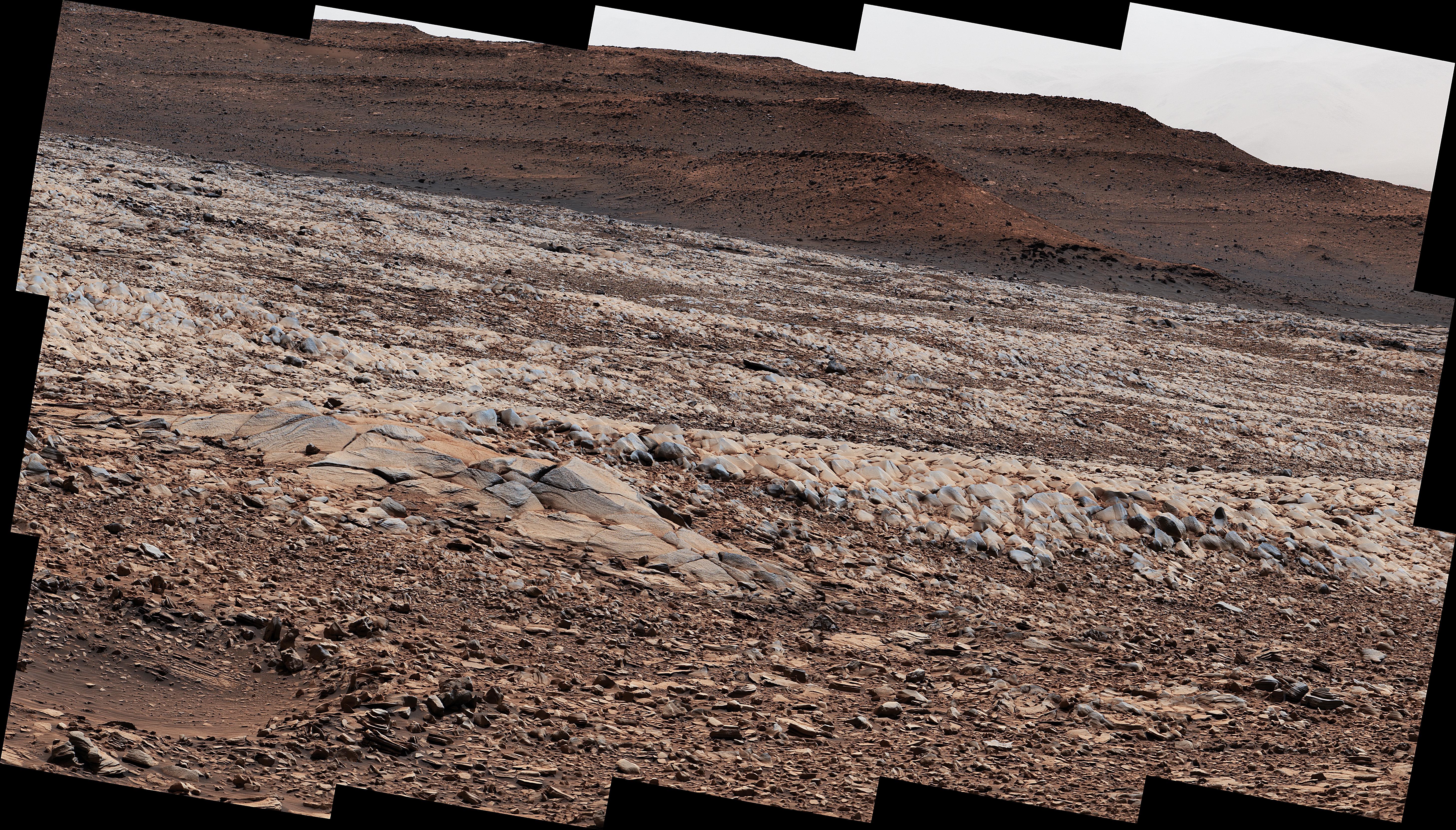
-
Curiosity Finds Gator-Back Rocks on Greenheugh
Full Resolution:
TIFF
(58.19 MB)
JPEG
(5.294 MB)
|
|
|
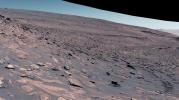
2022-04-07 |
Mars
|
Mars Science Laboratory (MSL)
|
Mastcam
|
29163x8101x3 |
|
-
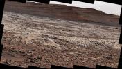
PIA25176:
Curiosity's 360-Degree Panorama of Gator-Back Rocks on Greenheugh
Full Resolution:
TIFF
(455.6 MB)
JPEG
(36.32 MB)
|
|
|
2022-05-18 |
Mars
|
Mars Science Laboratory (MSL)
|
Mastcam
|
7630x2295x3 |
|
-
PIA25288:
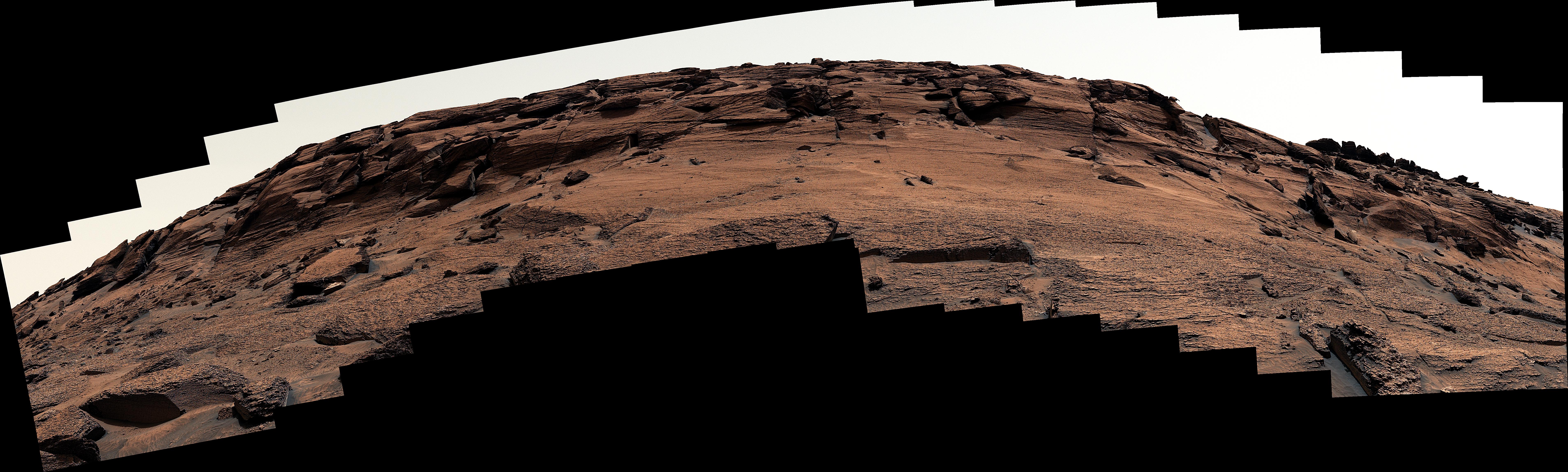
-
Door-Shaped Fracture Spotted by Curiosity at East Cliffs
Full Resolution:
TIFF
(30.19 MB)
JPEG
(2.872 MB)
|
|
|
2022-06-15 |
Mars
|
Mars Science Laboratory (MSL)
|
Mastcam
|
1338x1193x3 |
|
-
PIA25362:
-
Curiosity Spots Finger-Like Rocks
Full Resolution:
TIFF
(4.791 MB)
JPEG
(434.7 kB)
|
|
|
2022-06-22 |
Mars
|
Mars Science Laboratory (MSL)
|
Mastcam
|
17708x5681x3 |
|
-
PIA25365:
-
Curiosity's View of Haze During Dust Season
Full Resolution:
TIFF
(166.9 MB)
JPEG
(11.07 MB)
|
|
|
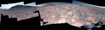
2022-06-22 |
Mars
|
Mars Science Laboratory (MSL)
|
Mastcam
|
29163x8571x3 |
|
-
PIA25366:
-
Curiosity's 360-degree Panorama Near Sierra Maigualida
Full Resolution:
TIFF
(442.9 MB)
JPEG
(33.48 MB)
|
|
|
2022-06-22 |
Mars
|
Mars Science Laboratory (MSL)
|
Mastcam
|
6325x2726x3 |
|
-
PIA25367:
-
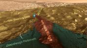
Curiosity's View of Sulfate-Bearing Region and Streambed Rocks
Full Resolution:
TIFF
(30.63 MB)
JPEG
(2.614 MB)
|
|
|
2022-06-22 |
Mars
|
Mars Science Laboratory (MSL)
|
Mastcam
|
4966x2494x3 |
|
-
PIA25368:
-
Curiosity's Mastcam Views Flaky, Streambed Rocks
Full Resolution:
TIFF
(27.36 MB)
JPEG
(1.796 MB)
|
|
|
2022-06-22 |
Mars
|
Mars Science Laboratory (MSL)
|
Mastcam
|
6057x3373x3 |
|
-
PIA25369:
-
Curiosity's Mastcam Views Layers at Las Claritas
Full Resolution:
TIFF
(61.32 MB)
JPEG
(4.871 MB)
|
|
|
2022-08-05 |
Mars
|
Mars Science Laboratory (MSL)
|
Mastcam
|
29163x8000x3 |
|
-
PIA25407:
Curiosity's 360-Degree Panorama of Avanavero Drill Site
Full Resolution:
TIFF
(495.9 MB)
JPEG
(38.13 MB)
|
|
|
2022-10-19 |
Mars
|
Mars Science Laboratory (MSL)
|
Mastcam
|
29163x8638x3 |
|
-
PIA25413:
-
Curiosity's View of Paraitepuy Pass
Full Resolution:
TIFF
(536.6 MB)
JPEG
(46.38 MB)
|
|
|
2022-10-19 |
Mars
|
Mars Science Laboratory (MSL)
|
Mastcam
|
8323x4225x3 |
|
-
PIA25414:
-
Curiosity's View of Sand Ridges and Bolívar
Full Resolution:
TIFF
(78.61 MB)
JPEG
(6.244 MB)
|
|
|
2022-10-19 |
Mars
|
Mars Science Laboratory (MSL)
|
Mastcam
|
2073x1226x3 |
|
-
PIA25415:
-
Curiosity's Close-Up of Rocks in Paraitepuy Pass
Full Resolution:
TIFF
(7.414 MB)
JPEG
(582.7 kB)
|
|
|
2022-10-19 |
Mars
|
Mars Science Laboratory (MSL)
|
MAHLI
|
3600x2700x3 |
|
-
PIA25416:
-
Curiosity's 36 Drill Holes
Full Resolution:
TIFF
(29.17 MB)
JPEG
(2.337 MB)
|
|
|
2022-10-19 |
Mars
|
Mars Science Laboratory (MSL)
|
Navigation Camera (M2020)
|
7696x2165x1 |

|
-
PIA25417:
Curiosity's Navcams View Paraitepuy Pass
Full Resolution:
TIFF
(11.31 MB)
JPEG
(1.471 MB)
|
|
|
2022-10-19 |
Mars
|
Mars Science Laboratory (MSL)
|
Mastcam
|
1328x1184x3 |
|
-
PIA25418:
-
Curiosity's 36th Drill Hole at Canaima
Full Resolution:
TIFF
(4.172 MB)
JPEG
(254.5 kB)
|
|
|
2023-02-02 |
Mars
|
Mars Science Laboratory (MSL)
|
Mastcam
|
8071x4719x3 |
|
-
PIA25737:
-
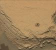
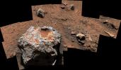
Curiosity Finds a Meteorite, 'Cacao'
Full Resolution:
TIFF
(74.32 MB)
JPEG
(5.559 MB)
|
|
|
2023-02-08 |
Mars
|
Mars Science Laboratory (MSL)
|
ChemCam
|
3000x930x1 |
|
-
PIA25731:
-
ChemCam Mosaic of Gediz Vallis Ridge
Full Resolution:
TIFF
(2.022 MB)
JPEG
(460.1 kB)
|
|
|
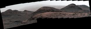
2023-02-08 |
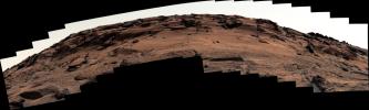
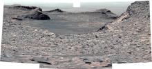
Mars
|
Mars Science Laboratory (MSL)
|
Mastcam
|
29163x8373x3 |
|
-
PIA25732:
-
Curiosity's 360-Degree View of Marker Band Valley
Full Resolution:
TIFF
(503.7 MB)
JPEG
(36.73 MB)
|
|
|
2023-02-08 |
Mars
|
Mars Science Laboratory (MSL)
|
Mastcam
|
10089x2399x3 |
|
-
PIA25733:
Curiosity Views Gediz Vallis
Full Resolution:
TIFF
(57.2 MB)
JPEG
(4.202 MB)
|
|
|
2023-02-08 |
Mars
|
Mars Science Laboratory (MSL)
|
Mastcam
|
9275x5809x3 |

|
-
PIA25734:
-
Curiosity Views Rhythmic Rock Layers
Full Resolution:
TIFF
(132.8 MB)
JPEG
(7.953 MB)
|
|
|
2023-03-06 |
Mars
|
Mars Science Laboratory (MSL)
|
Mastcam
|
3813x1024x3 |
|
-
PIA25739:
Curiosity Views First Martian 'Sun Rays'
Full Resolution:
TIFF
(7.479 MB)
JPEG
(97.4 kB)
|
|
|
2023-03-06 |
Mars
|
Mars Science Laboratory (MSL)
|
Mastcam
|
3417x1163x3 |
|
-
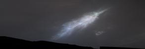
PIA25740:
-
Curiosity Views Feather-Shaped Iridescent Cloud
Full Resolution:
TIFF
(5.465 MB)
JPEG
(93.38 kB)
|
|
|
2023-05-08 |
Mars
|
Mars Science Laboratory (MSL)
|
MAHLI
|
1580x1179x3 |
|
-
PIA25828:
-
Curiosity Finds a Book-Like Rock
Full Resolution:
TIFF
(5.575 MB)
JPEG
(316.9 kB)
|
|
|
2023-06-08 |
Mars
|
Mars Science Laboratory (MSL)
|
|
13200x10200x3 |
|
-
PIA25914:
-
Curiosity's Quadrant Themes
Full Resolution:
TIFF
(147.4 MB)
JPEG
(15.53 MB)
|
|
|
2023-06-13 |
Mars
|
Mars Science Laboratory (MSL)
|
Navigation Camera (M2020)
|
3840x2160x3 |
|
-
PIA25912:
-
Curiosity's 'Postcard' of 'Marker Band Valley'
Full Resolution:
TIFF
(19.22 MB)
JPEG
(666.5 kB)
|
|
|
2023-08-03 |
Mars
|
Mars Science Laboratory (MSL)
|
Mastcam
|
9000x2641x3 |
|
-
PIA26014:
-
Curiosity Views a Crater at 'Jau'
Full Resolution:
TIFF
(45.85 MB)
JPEG
(3.742 MB)
|
|
|
2023-08-03 |
Mars
|
Mars Science Laboratory (MSL)
|
Navcam (MSL)
|
7696x2307x1 |

|
-
PIA26015:
-
Curiosity Views Its Tracks Using Its Navcam
Full Resolution:
TIFF
(11.71 MB)
JPEG
(1.667 MB)
|
|
|
2023-08-03 |
Mars
|
Mars Science Laboratory (MSL)
|
Mastcam
|
4617x2950x3 |
|
-
PIA25920:
-
Curiosity's Climb Attempt Leaves Tracks
Full Resolution:
TIFF
(30.24 MB)
JPEG
(2.791 MB)
|
|
|
2023-08-03 |
Mars
|
Mars Science Laboratory (MSL)
|
Mastcam
|
2892x1314x3 |
|
-
PIA26011:
-
Curiosity's View Back Toward 'Marker Band Valley'
Full Resolution:
TIFF
(11.1 MB)
JPEG
(1.224 MB)
|
|
|
2023-08-03 |
Mars
|
Mars Science Laboratory (MSL)
|
Mastcam
|
9000x2584x3 |
|
-
PIA26012:
-
Curiosity's View up a Challenging Slope
Full Resolution:
TIFF
(48.08 MB)
JPEG
(4.328 MB)
|
|
|
2023-08-03 |
Mars
|
Mars Science Laboratory (MSL)
|
Mastcam
|
5684x3174x3 |
|
-
PIA26013:
-
Curiosity's Attempted Climb up a Slope
Full Resolution:
TIFF
(54.15 MB)
JPEG
(5.622 MB)
|
|
|
2023-08-03 |
Mars
|
Mars Science Laboratory (MSL)
|
Navcam (MSL)
|
1024x1024x1 |

|
-
PIA26016:
-
Curiosity's Navcams View Its Wheels
Full Resolution:
TIFF
(1.05 MB)
JPEG
(187.4 kB)
|
|
|
2023-08-03 |
Mars
|
Mars Science Laboratory (MSL)
|
Navcam (MSL)
|
7696x1503x1 |
|
-
PIA26018:
Curiosity Looks Over the Hill
Full Resolution:
TIFF
(8.746 MB)
JPEG
(1.204 MB)
|
|
|
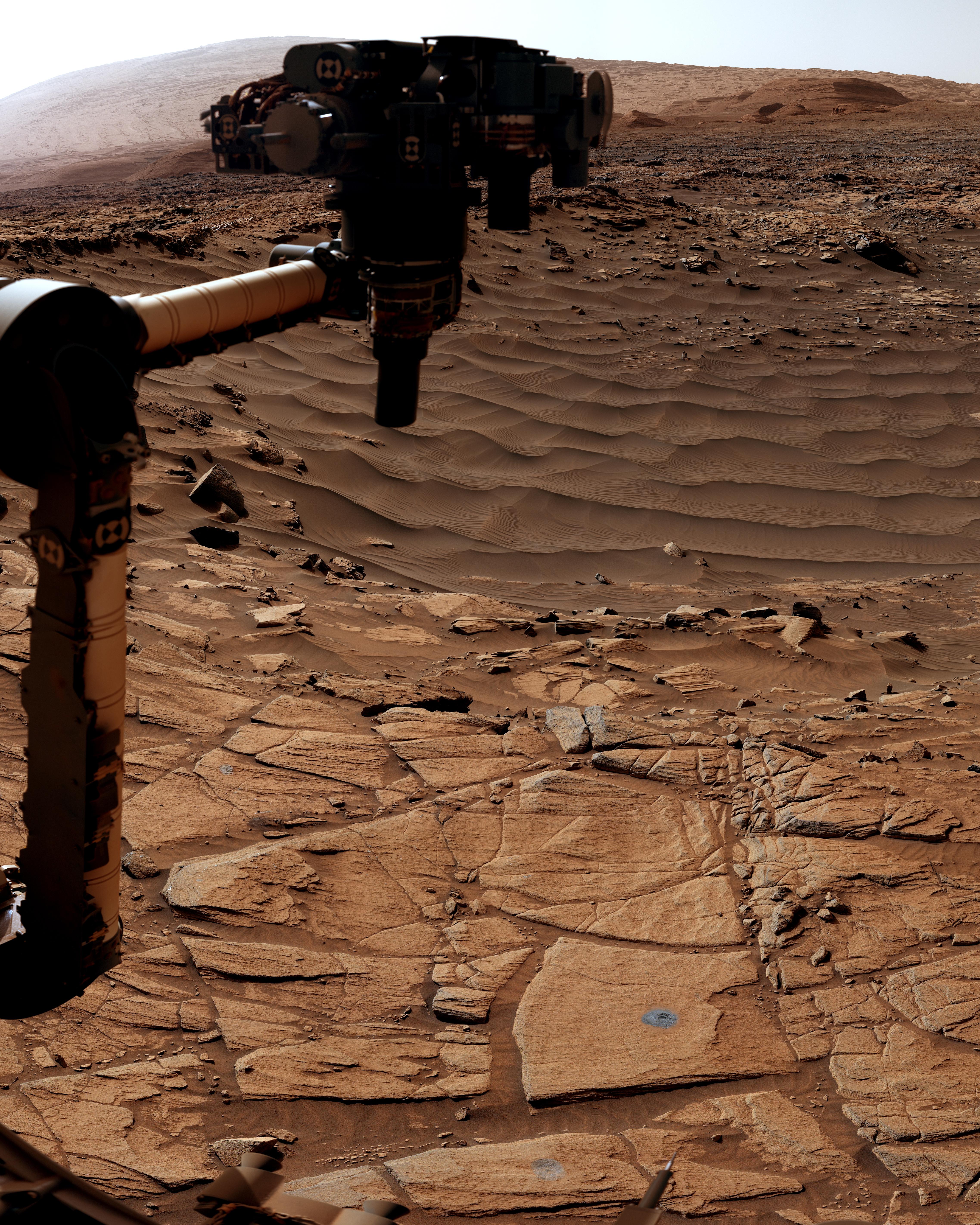
2023-08-09 |
Mars
|
Mars Science Laboratory (MSL)
|
Mastcam
|
29163x8162x3 |
|
-
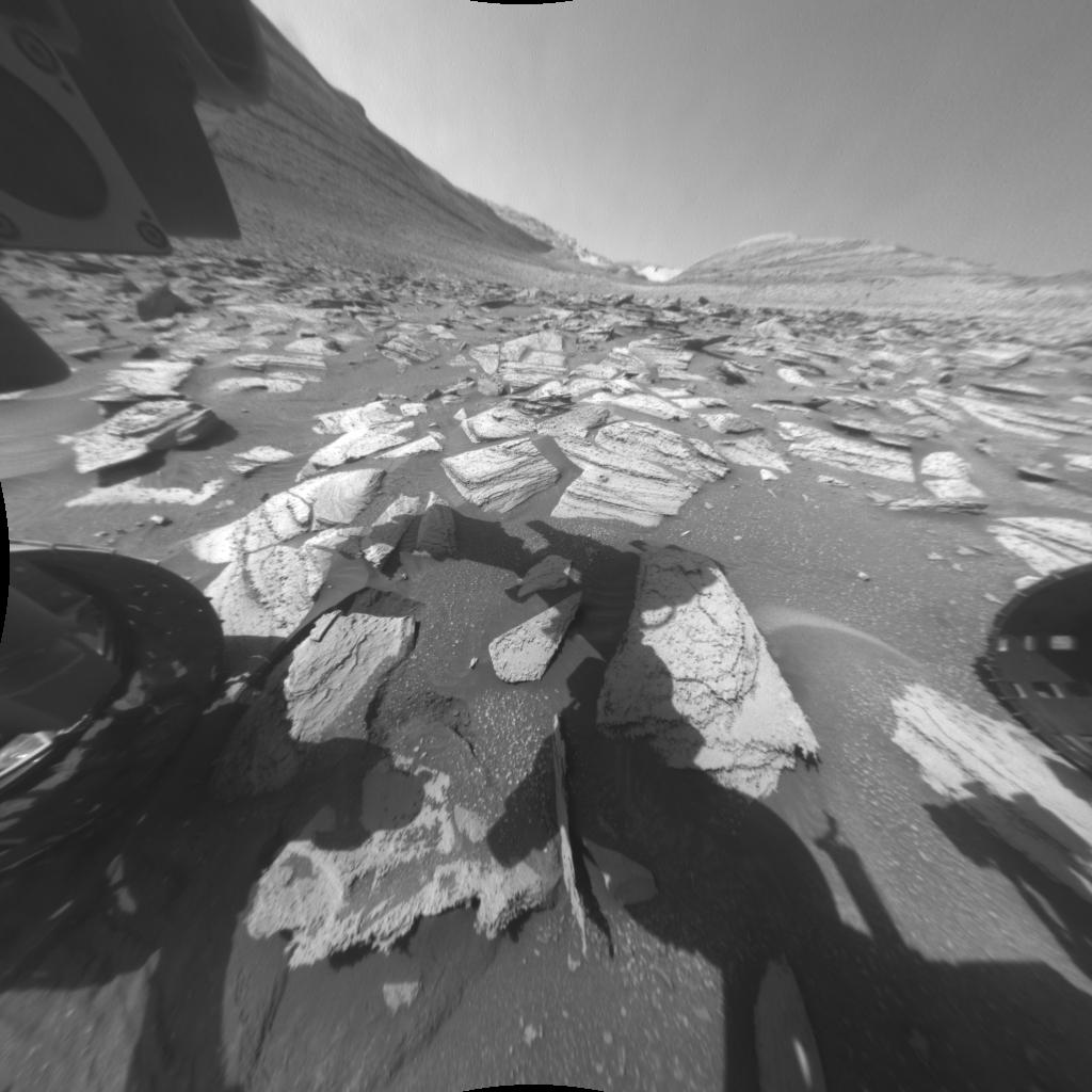
PIA25915:
Curiosity Views Mud Cracks in the Clay-Sulfate Transition Region
Full Resolution:
TIFF
(476.1 MB)
JPEG
(31.49 MB)
|
|
|
2023-09-18 |
Mars
|
Mars Science Laboratory (MSL)
|
Mastcam
|
9000x2394x3 |
|
-
PIA26019:
Curiosity Views Gediz Vallis Ridge
Full Resolution:
TIFF
(48.14 MB)
JPEG
(4.548 MB)
|
|
|
2023-09-18 |
Mars
|
Mars Science Laboratory (MSL)
|
|
3006x1813x3 |
|
-
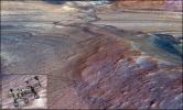
PIA26020:
-
Rendering Depicts Curiosity at Gediz Vallis Ridge
Full Resolution:
TIFF
(16.36 MB)
JPEG
(960.6 kB)
|
|
|
2023-09-18 |
Mars
|
Mars Science Laboratory (MSL)
|
|
1280x720x3 |
|
-
PIA26042:
-
Curiosity's Path to Gediz Vallis Ridge and Beyond
Full Resolution:
TIFF
(2.571 MB)
JPEG
(183.2 kB)
|
|
|
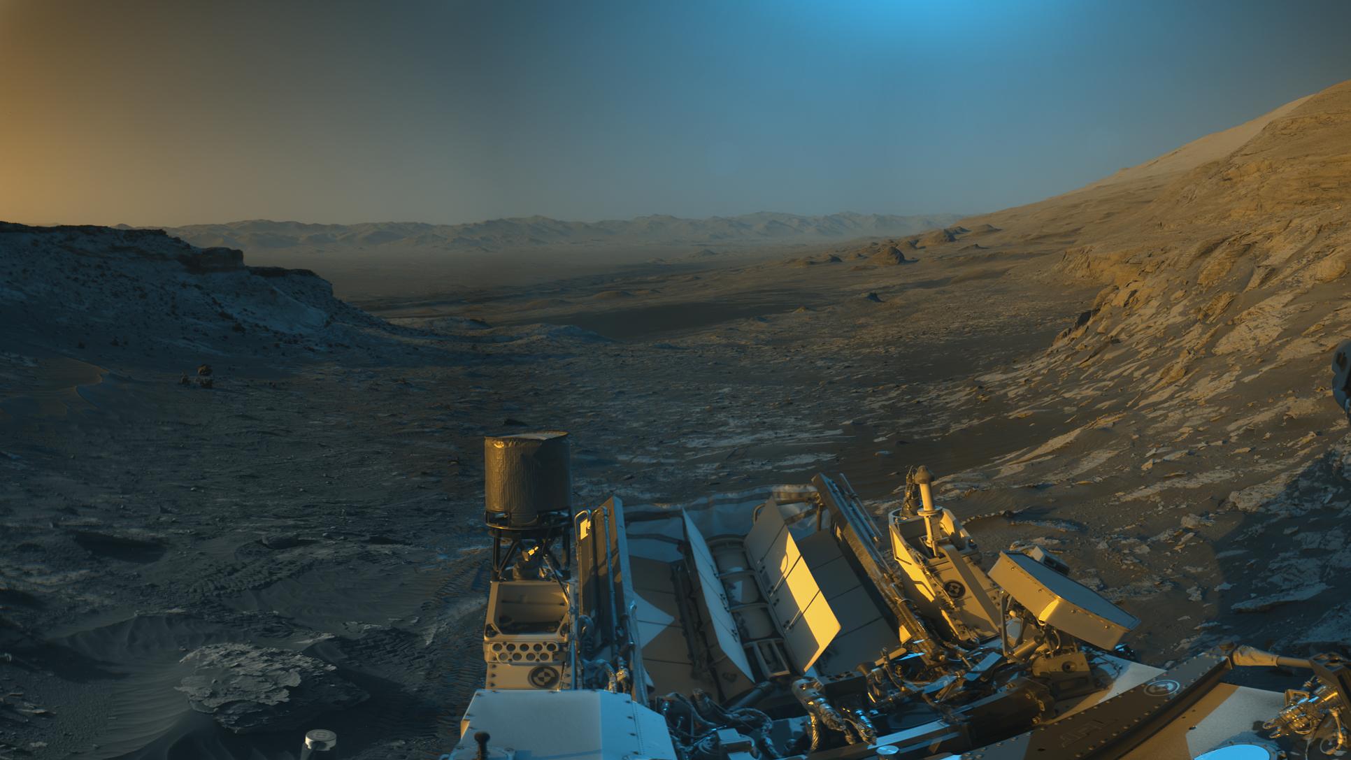
2023-11-06 |
Mars
|
Mars Science Laboratory (MSL)
|
Mastcam
|
1504x1000x3 |
|
-
PIA26043:
-
Curiosity Mastcam Filter Wheel
Full Resolution:
TIFF
(3.852 MB)
JPEG
(134.8 kB)
|
|
|
2023-11-06 |
Mars
|
Mars Science Laboratory (MSL)
|
Navcam (MSL)
|
7665x2111x1 |
|
-
PIA26047:
Curiosity's Navcams View the Area Around 'Sequoia'
Full Resolution:
TIFF
(12.18 MB)
JPEG
(1.953 MB)
|
|
|
2023-11-06 |
Mars
|
Mars Science Laboratory (MSL)
|
Mastcam
|
1583x1482x3 |
|
-
PIA26048:
-
Curiosity Views 'Sequoia' Using Its Mastcam
Full Resolution:
TIFF
(5.387 MB)
JPEG
(433.2 kB)
|
|
|
2024-01-08 |
Mars
|
Mars Science Laboratory (MSL)
|
Hazcam (MSL)
|
1024x1024x1 |

|
-
PIA26209:
-
Curiosity's Hazcams Capture a Day on Mars
Full Resolution:
TIFF
(979 kB)
JPEG
(106.3 kB)
|
|
|
2024-03-29 |
Mars
|
Mars Science Laboratory (MSL)
|
Navcam (MSL)
|
7696x2774x1 |
|
-
PIA26246:
-
Curiosity Arrives at Gediz Vallis Channel
Full Resolution:
TIFF
(14.07 MB)
JPEG
(2.033 MB)
|
|
|
2024-03-29 |
Mars
|
Mars Science Laboratory (MSL)
|
Navcam (MSL)
|
3432x1503x1 |
|
-
PIA26247:
-
Curiosity Looks Back Down the Slope
Full Resolution:
TIFF
(3.619 MB)
JPEG
(569.4 kB)
|
|
|
2024-03-29 |
Mars
|
Mars Science Laboratory (MSL)
|
Navcam (MSL)
|
5759x5759x1 |
|
-
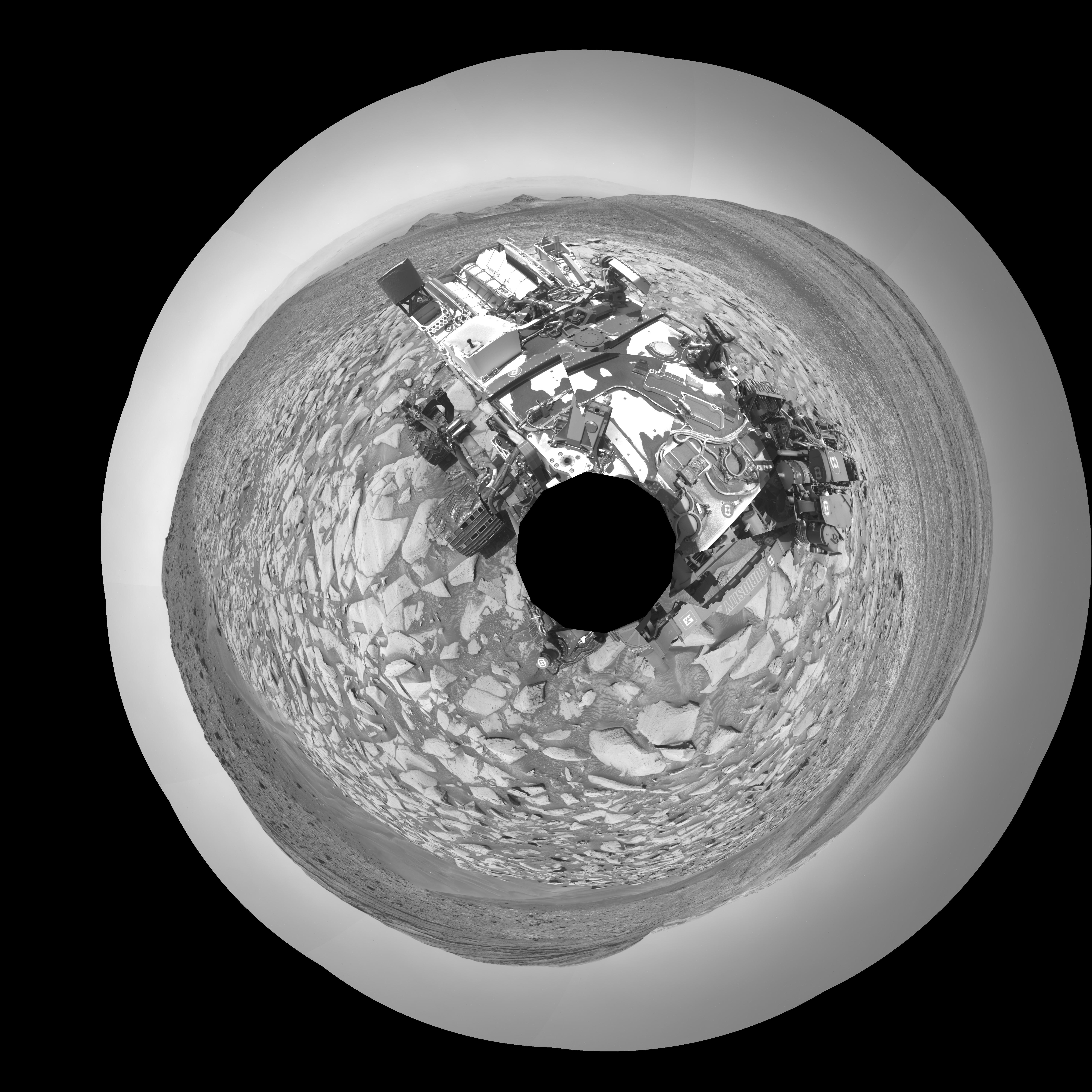
PIA26310:
-
Curiosity Takes a Navcam Selfie
Full Resolution:
TIFF
(18.79 MB)
JPEG
(2.288 MB)
|
|
|
2012-08-06 |
Mars
|
Mars Reconnaissance Orbiter (MRO)
Mars Science Laboratory (MSL)
|
HiRISE
|
911x601x1 |
|
-
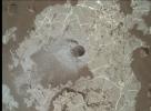
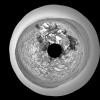
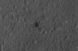
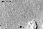
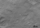
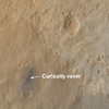
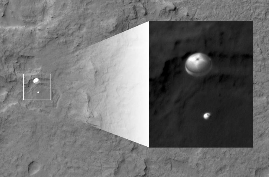
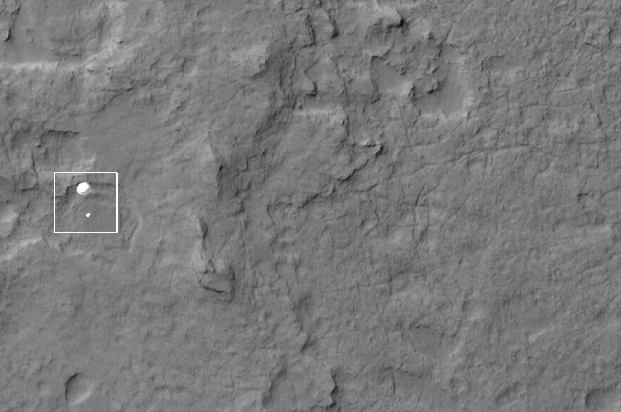
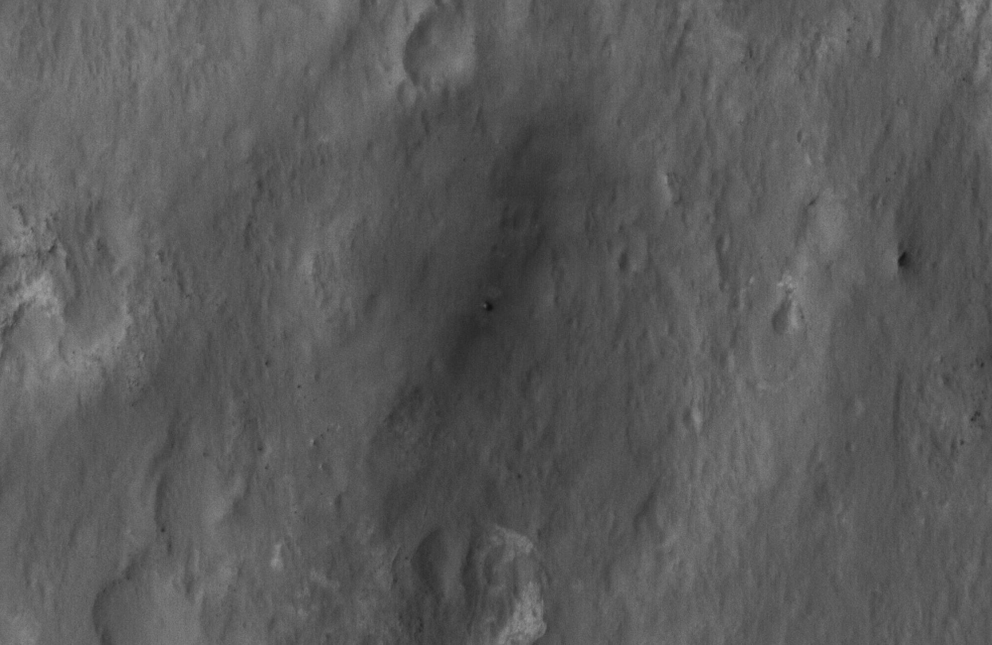
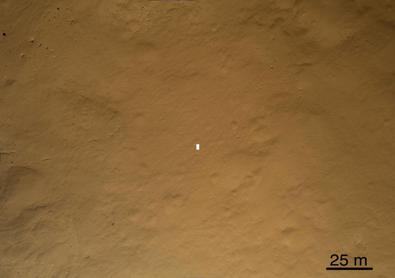
PIA15978:
-
Curiosity Spotted on Parachute by Orbiter
Full Resolution:
TIFF
(548.3 kB)
JPEG
(51.73 kB)
|
|
|
2012-08-06 |
Mars
|
Mars Reconnaissance Orbiter (MRO)
Mars Science Laboratory (MSL)
|
HiRISE
|
2047x1357x1 |
|
-
PIA15980:
-
Curiosity Spotted on Parachute by Orbiter
Full Resolution:
TIFF
(2.781 MB)
JPEG
(251.3 kB)
|
|
|
2012-08-06 |
Mars
|
Mars Reconnaissance Orbiter (MRO)
Mars Science Laboratory (MSL)
|
HiRISE
|
2048x9645x1 |
|
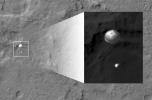
-
PIA15983:
-
Curiosity Flying Over Mars
Full Resolution:
TIFF
(19.77 MB)
JPEG
(2.527 MB)
|
|
|
2012-08-06 |
Mars
|
Mars Reconnaissance Orbiter (MRO)
Mars Science Laboratory (MSL)
|
HiRISE
|
176x215x1 |
|
-
PIA15979:
-
Curiosity Spotted on Parachute by Orbiter
Full Resolution:
TIFF
(38.1 kB)
JPEG
(2.85 kB)
|
|
|
2012-08-07 |
Mars
|
Mars Reconnaissance Orbiter (MRO)
Mars Science Laboratory (MSL)
|
HiRISE
|
931x1213x1 |
|
-
PIA15993:
-
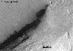
Curiosity Sails to Mars as Heat Shield Falls Away
Full Resolution:
TIFF
(1.131 MB)
JPEG
(103.8 kB)
|
|
|
2012-08-07 |
Mars
|
Mars Reconnaissance Orbiter (MRO)
Mars Science Laboratory (MSL)
|
HiRISE
|
2000x1300x1 |
|
-
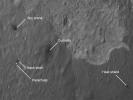
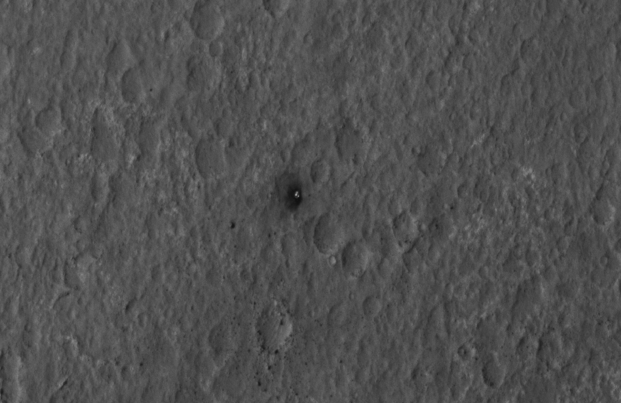
PIA15997:
-
Final Resting Spot for Curiosity's Heat Shield
Full Resolution:
TIFF
(2.603 MB)
JPEG
(270.9 kB)
|
|
|
2012-08-07 |
Mars
|
Mars Reconnaissance Orbiter (MRO)
Mars Science Laboratory (MSL)
|
HiRISE
|
882x996x1 |

|
-
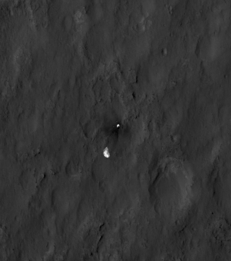
PIA15998:
-
Evidence of a Job Well Done
Full Resolution:
TIFF
(879.6 kB)
JPEG
(59.95 kB)
|
|
|
2012-08-07 |
Mars
|
Mars Reconnaissance Orbiter (MRO)
Mars Science Laboratory (MSL)
|
HiRISE
|
2000x1300x1 |

|
-
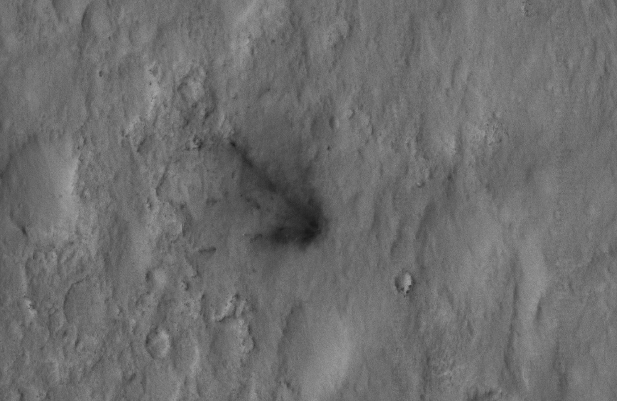
PIA15999:
-
Signs of the Sky Crane's Impact
Full Resolution:
TIFF
(2.603 MB)
JPEG
(282.5 kB)
|
|
|
2012-08-07 |
Mars
|
Mars Reconnaissance Orbiter (MRO)
Mars Science Laboratory (MSL)
|
HiRISE
|
2000x1300x1 |
|
-
PIA16000:
-
Curiosity Spotted!
Full Resolution:
TIFF
(2.603 MB)
JPEG
(249.2 kB)
|
|
|
2012-08-07 |
Mars
|
Mars Reconnaissance Orbiter (MRO)
Mars Science Laboratory (MSL)
|
HiRISE
|
946x710x1 |
|
-
PIA16001:
-
Scene of a Martian Landing
Full Resolution:
TIFF
(672.6 kB)
JPEG
(94.16 kB)
|
|
|
2012-08-08 |
Mars
|
Mars Reconnaissance Orbiter (MRO)
Mars Science Laboratory (MSL)
|
CTX
|
1709x1193x1 |
|
-
PIA16014:
-
Before and After Curiosity's Touchdown

Full Resolution:
TIFF
(2.041 MB)
JPEG
(305.4 kB)
|
|
|
2012-08-08 |
Mars
|
Mars Reconnaissance Orbiter (MRO)
Mars Science Laboratory (MSL)
|
CTX
|
758x511x1 |
|
-
PIA16016:
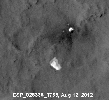
-
Ballasts Hitting the Surface, Close-Up
Full Resolution:
TIFF
(388 kB)
JPEG
(58 kB)
|
|
|
2012-08-08 |
Mars
|
Mars Reconnaissance Orbiter (MRO)
Mars Science Laboratory (MSL)
|
CTX
|
758x511x1 |

|
-
PIA16015:
-
Ballasts Hitting the Surface, Close-Up (with arrows)
Full Resolution:
TIFF
(388 kB)
JPEG
(58.05 kB)
|
|
|
2012-08-08 |
Mars
|
Mars Reconnaissance Orbiter (MRO)
Mars Science Laboratory (MSL)
|
HiRISE
MARDI
|
1665x1174x3 |
|
-
PIA16019:
-
A Better Look of the Martian Surface
Full Resolution:
TIFF
(5.867 MB)
JPEG
(153.7 kB)
|
|
|
2012-08-09 |
Mars
|
Mars Reconnaissance Orbiter (MRO)
Mars Science Laboratory (MSL)
|
HiRISE
|
724x720x1 |
|
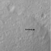
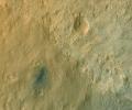
-
PIA16030:
-
Curiosity's Quad
Full Resolution:
TIFF
(522 kB)
JPEG
(63.57 kB)
|
|
|
2012-08-09 |
Mars
|
Mars Reconnaissance Orbiter (MRO)
Mars Science Laboratory (MSL)
|
HiRISE
|
862x650x3 |
|
-
PIA16031:
-
Staking out Curiosity's Landing Site
Full Resolution:
TIFF
(1.682 MB)
JPEG
(99.91 kB)
|
|
|
2012-08-10 |
Mars
|
Mars Reconnaissance Orbiter (MRO)
Mars Science Laboratory (MSL)
|
MARCI
|
1449x1087x3 |
|
-
PIA16037:
-
Mars Weather Map, Aug. 5
Full Resolution:
TIFF
(4.727 MB)
JPEG
(123.9 kB)
|
|
|
2012-08-14 |
Mars
|
Mars Reconnaissance Orbiter (MRO)
Mars Science Laboratory (MSL)
|
HiRISE
|
1511x13401x3 |
|
-
PIA16056:
-
A Whole New World for Curiosity
Full Resolution:
TIFF
(60.77 MB)
JPEG
(2.358 MB)
|
|
|
2012-08-14 |
Mars
|
Mars Reconnaissance Orbiter (MRO)
Mars Science Laboratory (MSL)
|
HiRISE
|
3022x2515x3 |
|
-
PIA16057:
-
Curiosity in Exaggerated Color
Full Resolution:
TIFF
(22.81 MB)
JPEG
(1.151 MB)
|
|
|
2012-09-19 |
Mars
|
Mars Reconnaissance Orbiter (MRO)
Mars Science Laboratory (MSL)
|
HiRISE
|
3300x2550x3 |
|
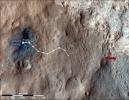
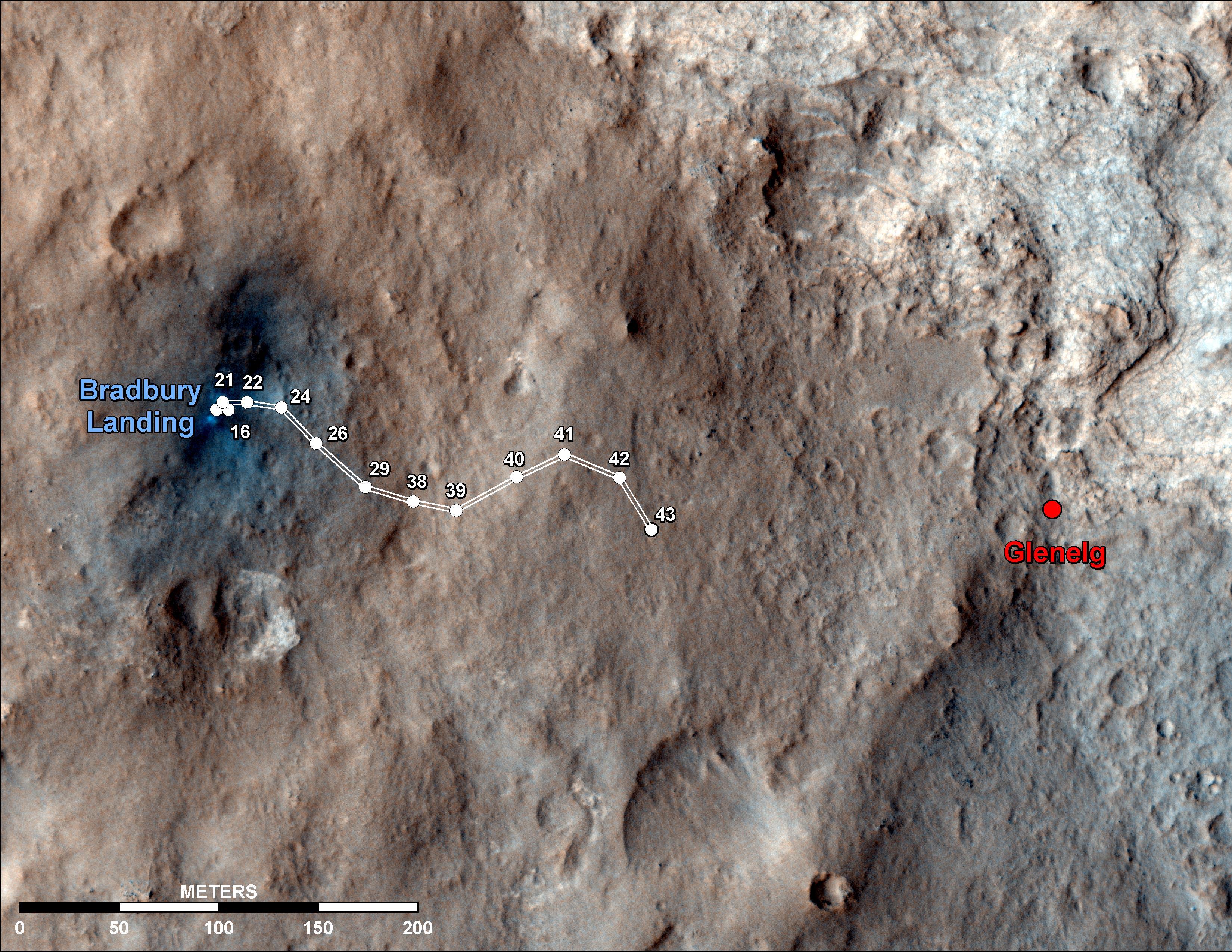
-
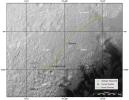
PIA16153:
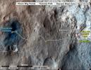
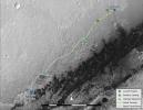
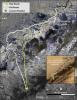
-
Curiosity Traverse Map Through Sol 43
Full Resolution:
TIFF
(25.26 MB)
JPEG
(1.57 MB)
|
|
|
2012-09-27 |
Mars
|
Mars Reconnaissance Orbiter (MRO)
Mars Science Laboratory (MSL)
|
HiRISE
|
932x720x3 |
|
-
PIA16157:
-
Curiosity's Roadside Discoveries
Full Resolution:
TIFF
(2.014 MB)
JPEG
(132.4 kB)
|
|
|
2012-09-27 |
Mars
|
Mars Reconnaissance Orbiter (MRO)
Mars Science Laboratory (MSL)
|
HiRISE
|
3339x2580x3 |

|
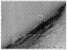
-
PIA16158:
-
Where Water Flowed Downslope
Full Resolution:
TIFF
(25.85 MB)
JPEG
(1.87 MB)
|
|
|
2012-10-10 |
Mars
|
Mars Reconnaissance Orbiter (MRO)
Mars Science Laboratory (MSL)
|
HiRISE
|
398x408x3 |
|
-
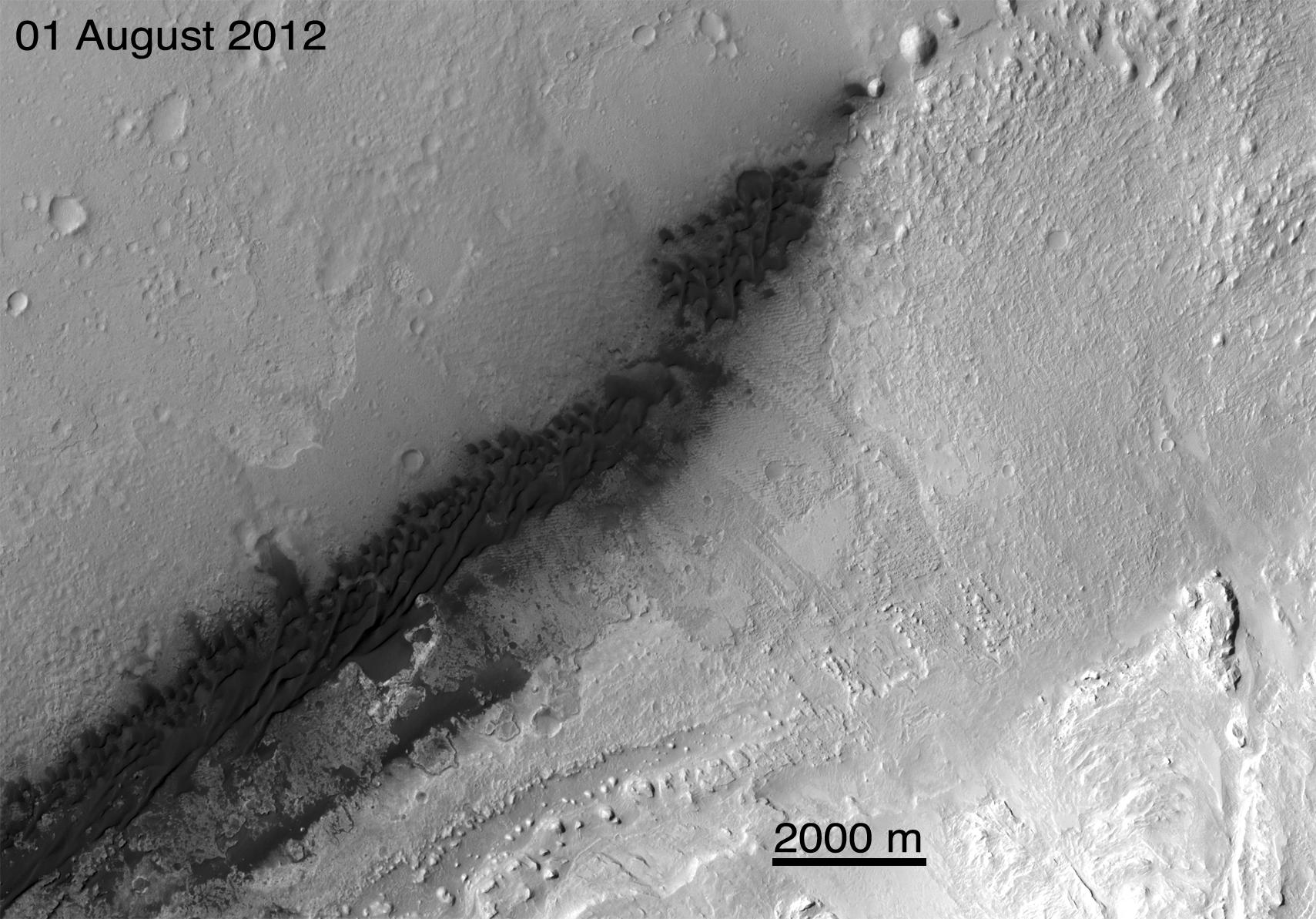
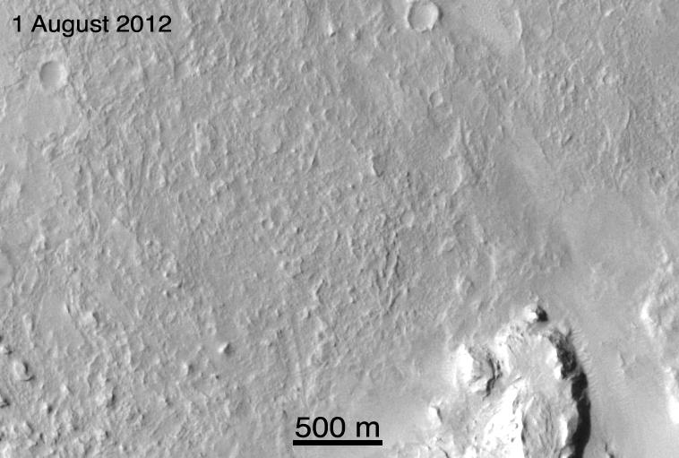
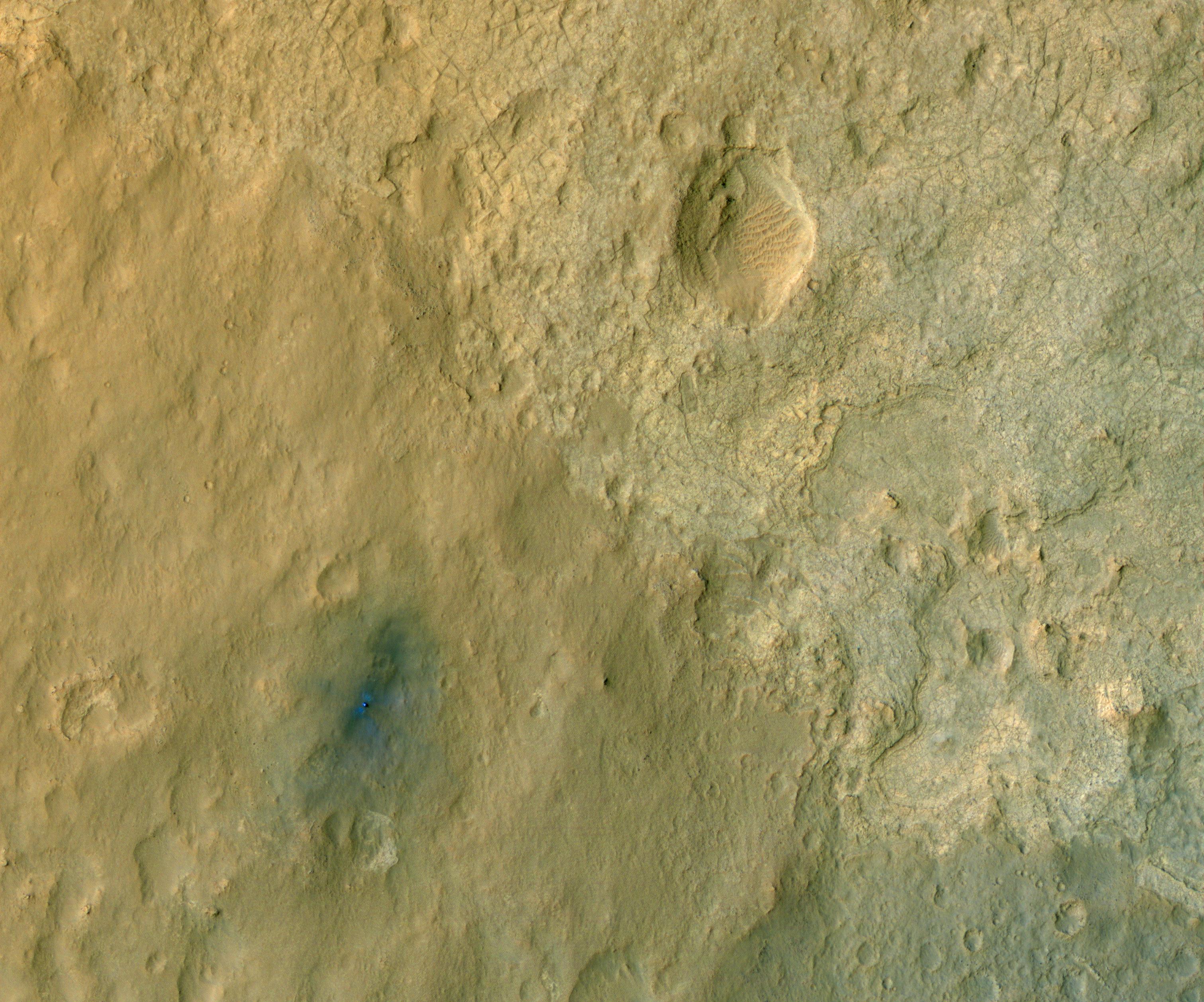
PIA16208:
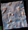
-
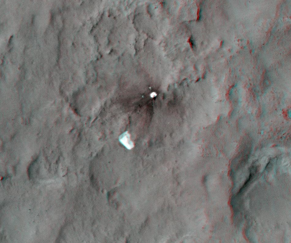
Curiosity at Bradbury Landing Site in 3-D
Full Resolution:
TIFF
(487.5 kB)
JPEG
(17.84 kB)
|
|
|
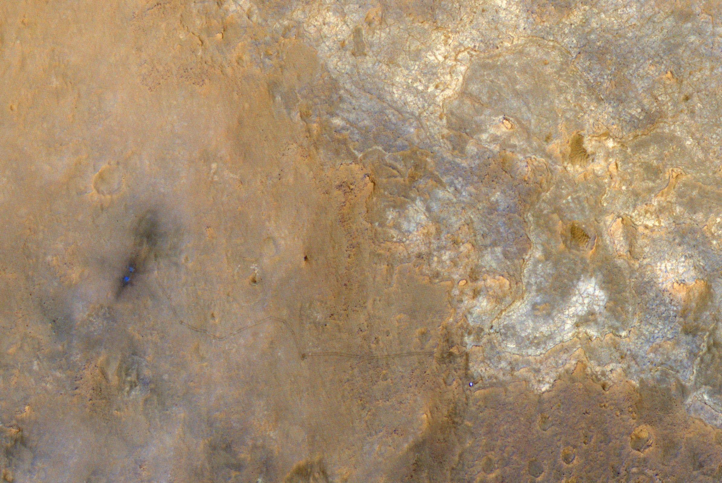
2012-10-10 |
Mars
|
Mars Reconnaissance Orbiter (MRO)
Mars Science Laboratory (MSL)
|
HiRISE
|
950x795x3 |
|
-
PIA16209:
-
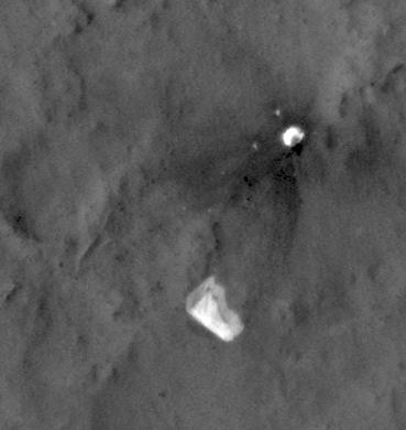
Parachute and Back Shell in 3-D
Full Resolution:
TIFF
(2.267 MB)
JPEG
(87.85 kB)
|
|
|
2012-10-10 |
Mars
|
Mars Reconnaissance Orbiter (MRO)
Mars Science Laboratory (MSL)
|
HiRISE
|
2414x1387x3 |
|
-
PIA16210:
-
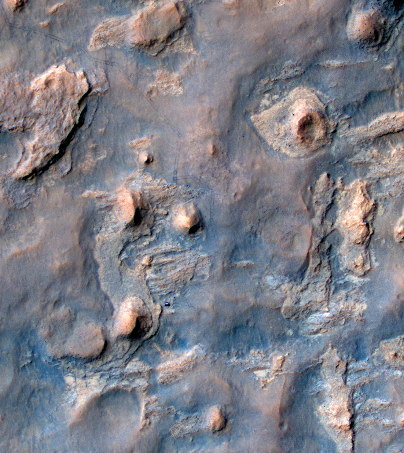
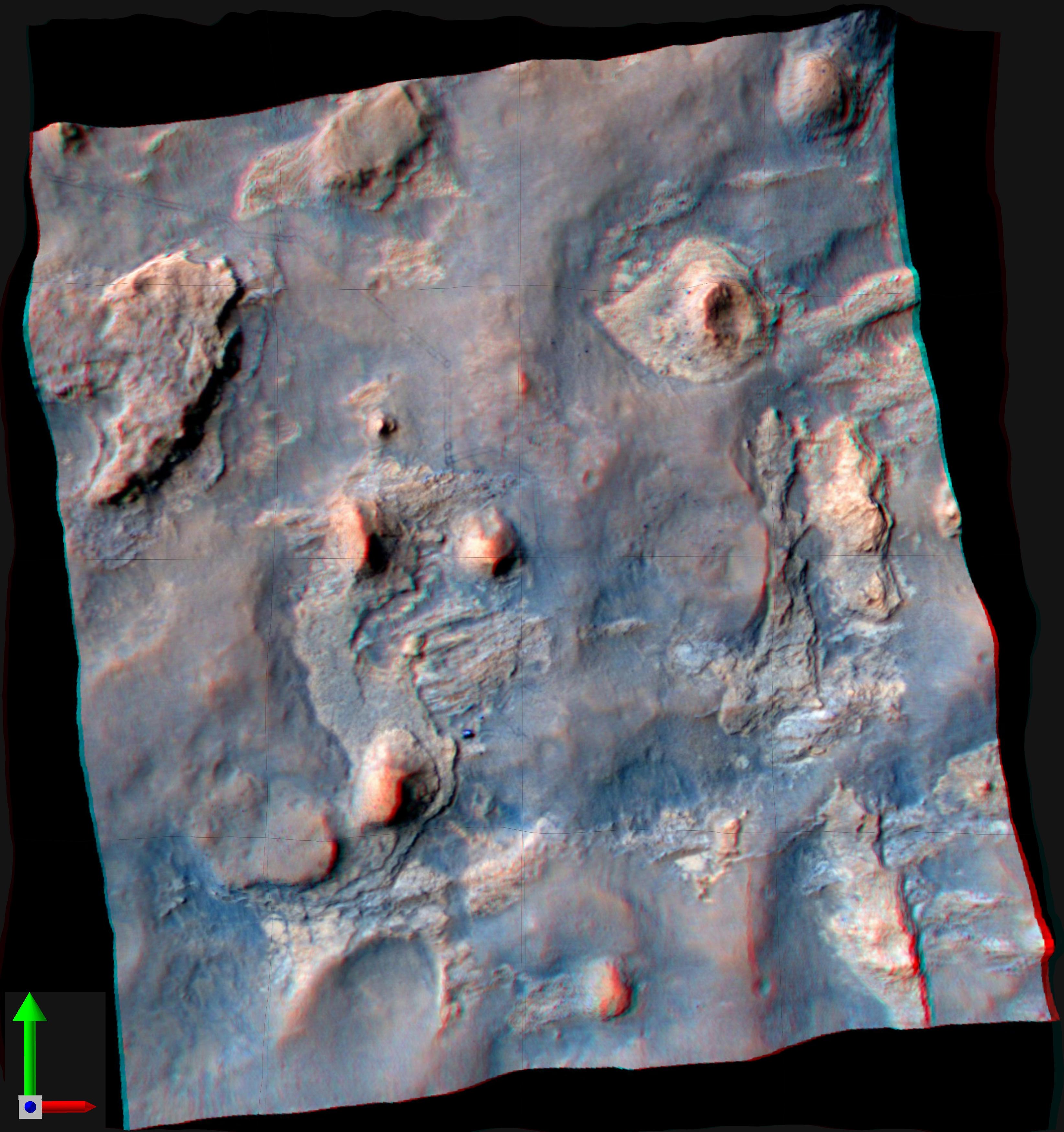
'Glenelg' in 3-D
Full Resolution:
TIFF
(10.05 MB)
JPEG
(554.1 kB)
|
|
|
2012-12-03 |
Mars
|
Mars Reconnaissance Orbiter (MRO)
Mars Science Laboratory (MSL)
|
HiRISE
|
3300x2550x3 |
|
-
PIA16577:
-
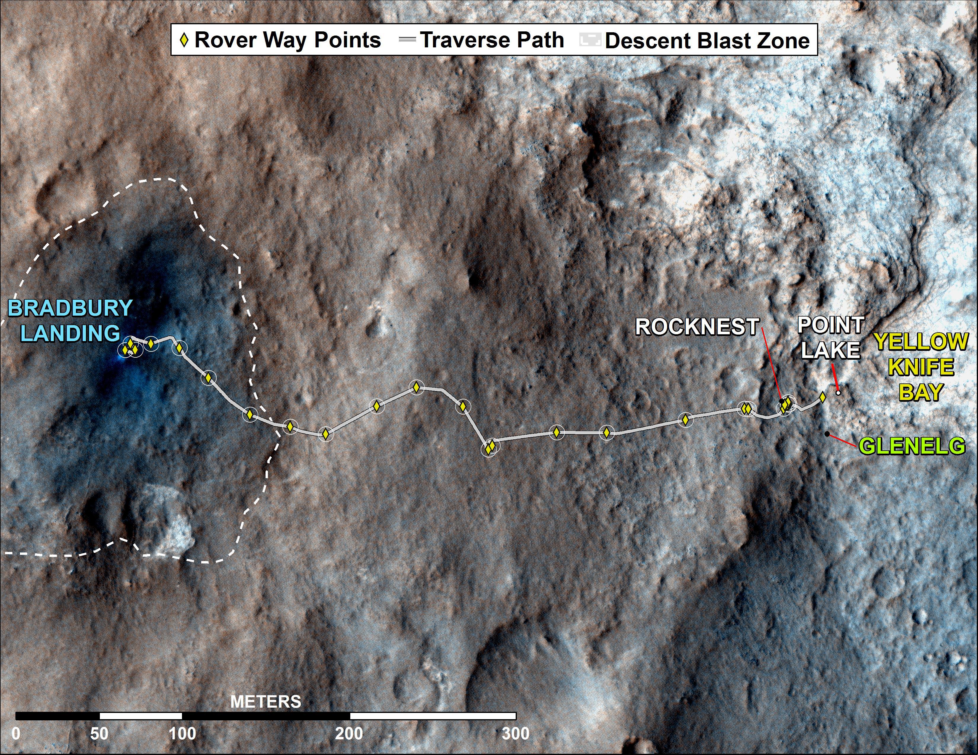
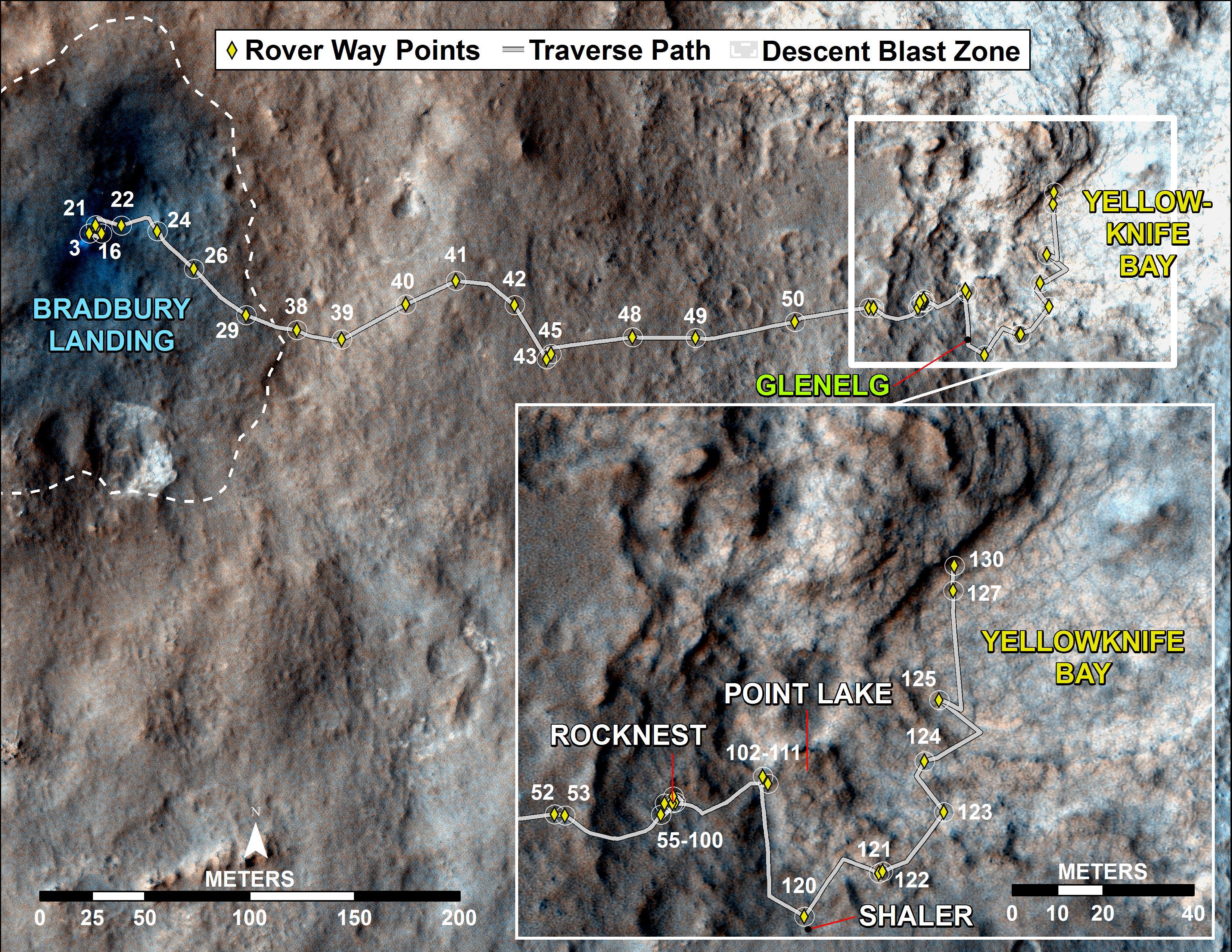
Curiosity Rover's Traverse, August through November 2012
Full Resolution:
TIFF
(25.26 MB)
JPEG
(1.893 MB)
|
|
|
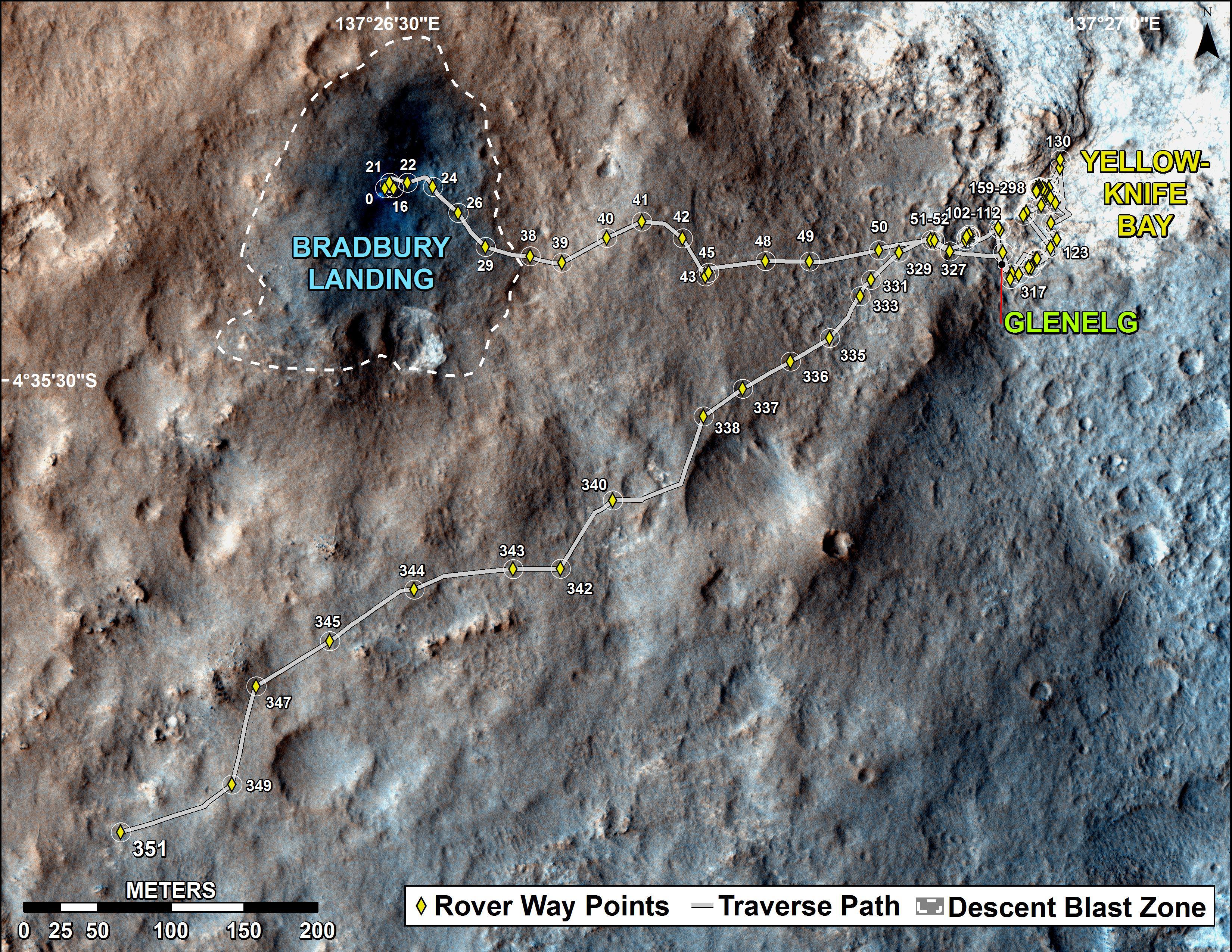
2012-12-18 |
Mars
|
Mars Reconnaissance Orbiter (MRO)
Mars Science Laboratory (MSL)
|
HiRISE
|
3300x2550x3 |

|
-
PIA16554:
-
Curiosity Traverse Map, Sol 130
Full Resolution:
TIFF
(25.26 MB)
JPEG
(1.761 MB)
|
|
|
2013-04-03 |
Mars
|
Mars Reconnaissance Orbiter (MRO)
Mars Science Laboratory (MSL)
|
HiRISE
|
369x390x1 |
|
-
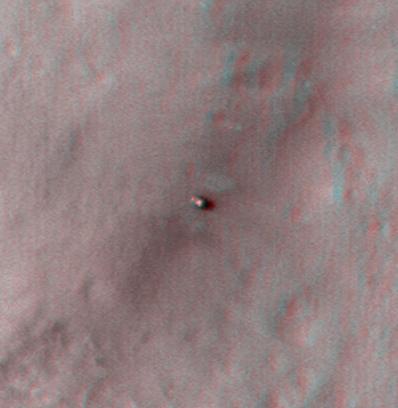
PIA16813:
-
MSL's Parachute Flapping in the Wind
Full Resolution:
TIFF
(144.3 kB)
JPEG
(15.5 kB)
|
|
|
2013-07-24 |
Mars
|
Mars Reconnaissance Orbiter (MRO)
Mars Science Laboratory (MSL)
|
HiRISE
|
2389x1598x3 |
|
-
PIA17080:
-
View From Mars Orbiter Showing Curiosity Rover at 'Shaler'
Full Resolution:
TIFF
(11.46 MB)
JPEG
(879.4 kB)
|
|
|
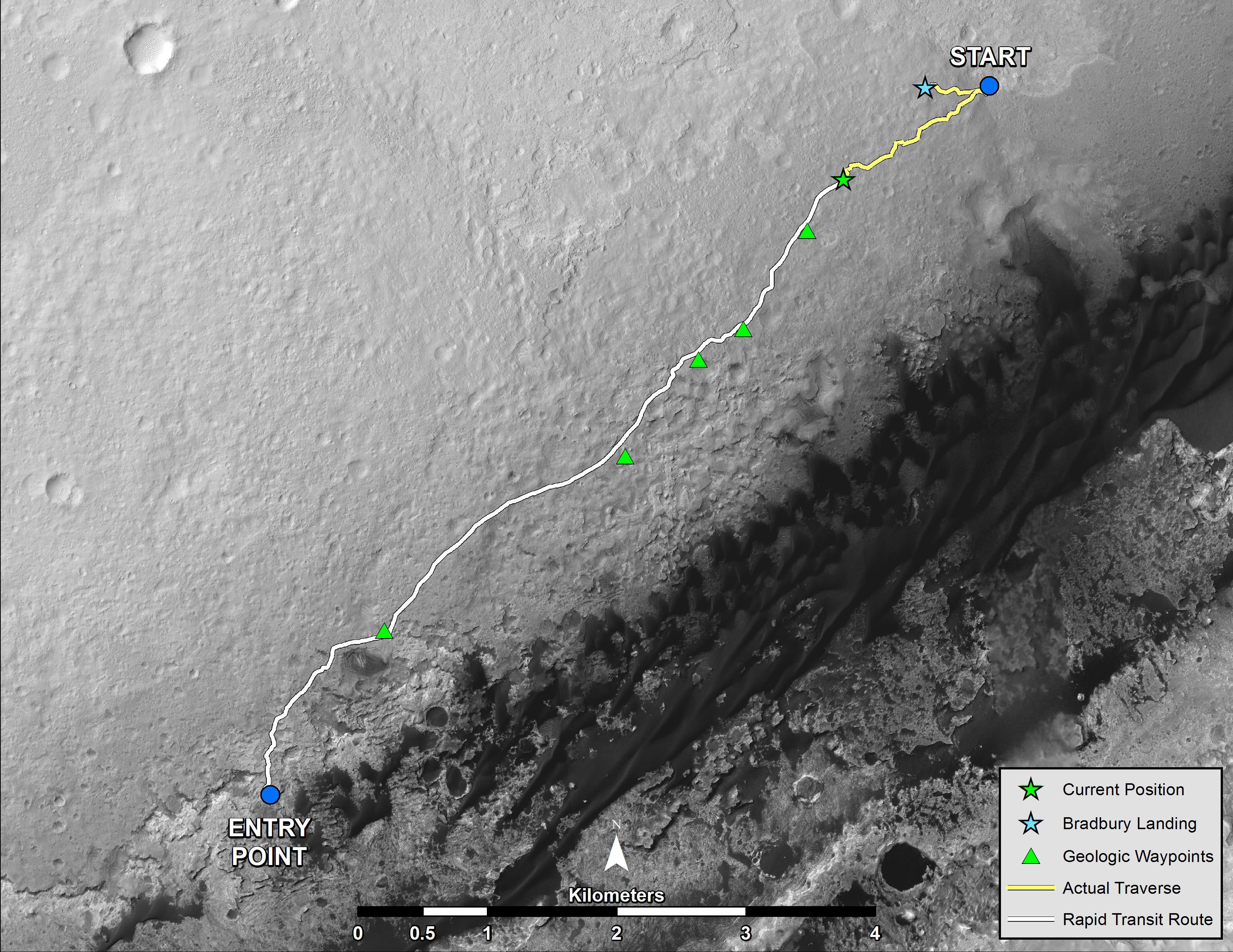
2013-08-02 |
Mars
|
Mars Reconnaissance Orbiter (MRO)
Mars Science Laboratory (MSL)
|
HiRISE
|
3300x2550x3 |

|
-
PIA17085:
-
Full Curiosity Traverse Passes One-Mile Mark
Full Resolution:
TIFF
(25.26 MB)
JPEG
(2.249 MB)
|
|
|
2013-08-27 |
Mars
|
Mars Reconnaissance Orbiter (MRO)
Mars Science Laboratory (MSL)
|
HiRISE
|
3300x2550x3 |
|
-
PIA17355:
-
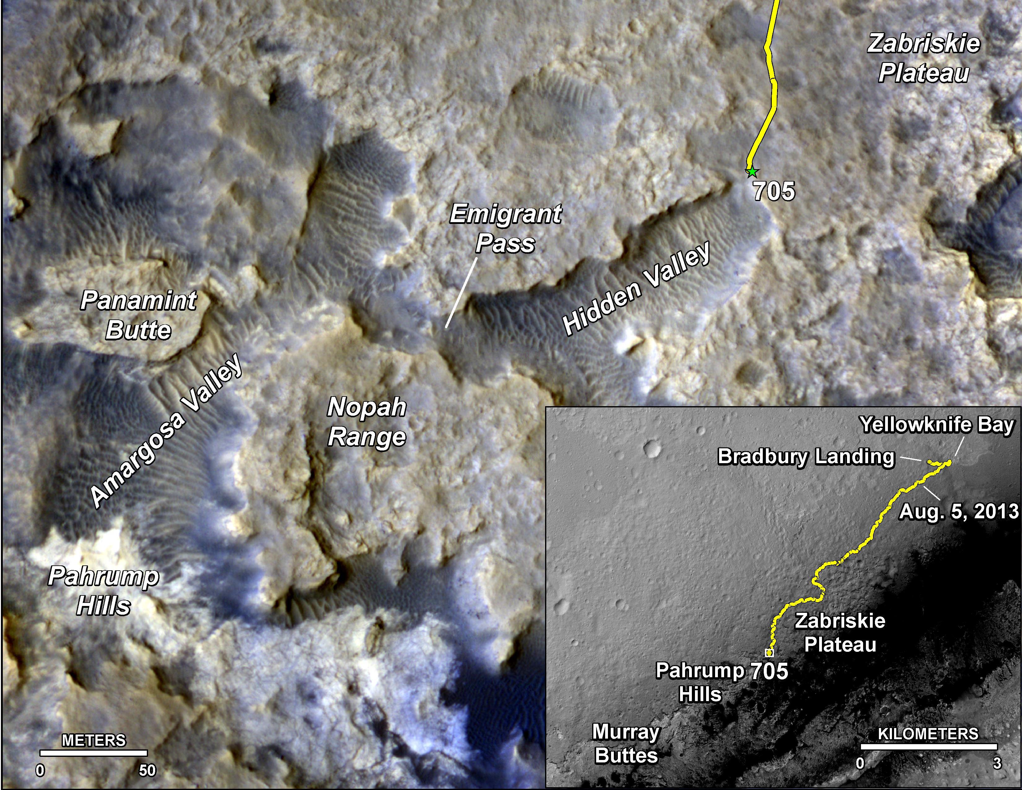
Curiosity's Progress on Route from 'Glenelg' to Mount Sharp
Full Resolution:
TIFF
(25.26 MB)
JPEG
(1.493 MB)
|
|
|
2013-12-09 |
Mars
|
Mars Reconnaissance Orbiter (MRO)
Mars Science Laboratory (MSL)
|
CTX
|
3300x2550x3 |
|
-
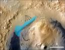
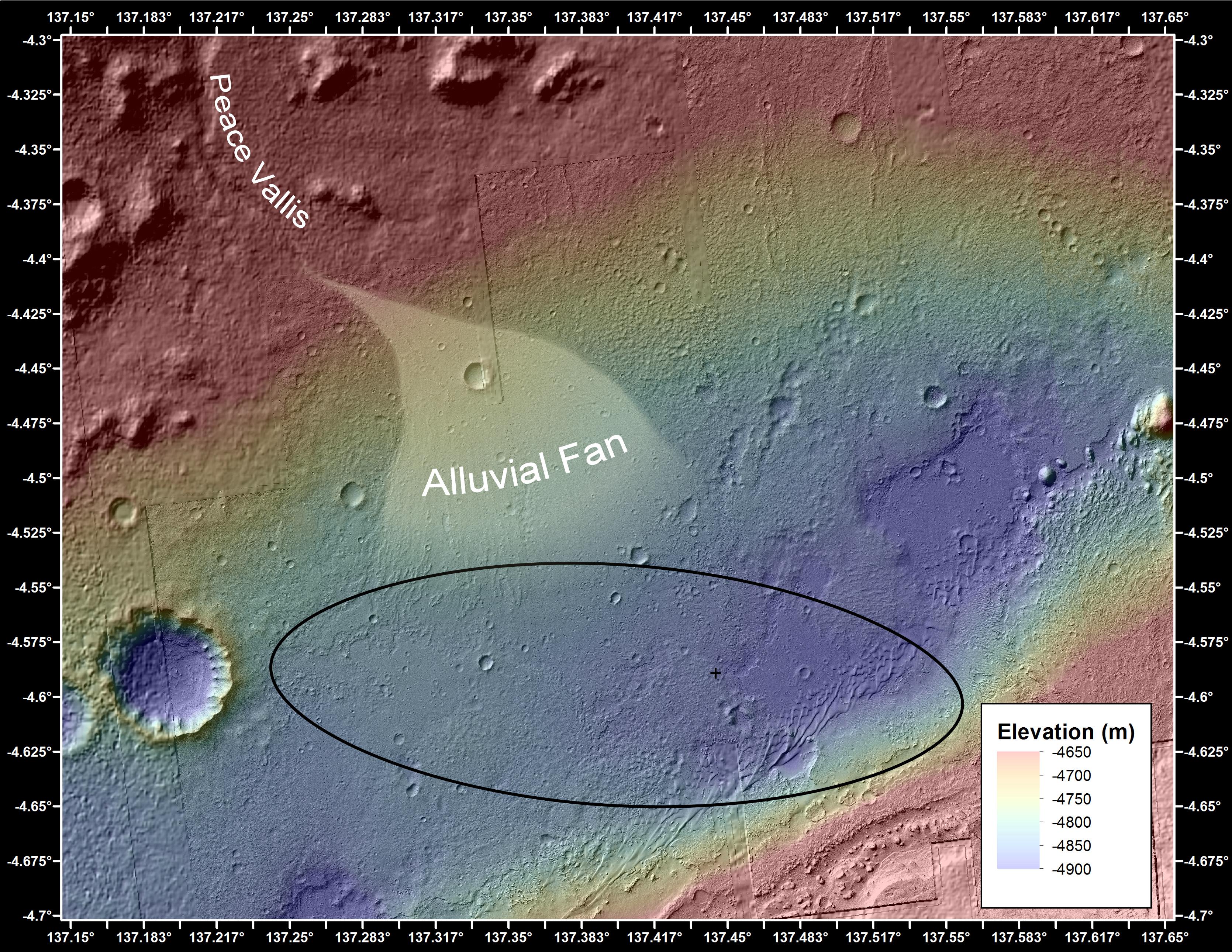
PIA17596:
-
Possible Extent of Ancient Lake in Gale Crater, Mars
Full Resolution:
TIFF
(25.26 MB)
JPEG
(1.34 MB)
|
|
|
2014-01-29 |
Mars
|
Mars Reconnaissance Orbiter (MRO)
Mars Science Laboratory (MSL)
|
HiRISE
|
3300x2550x3 |
|
-
PIA17765:
-
Traverse Map for Mars Rover Curiosity as of Jan. 26, 2014
Full Resolution:
TIFF
(25.26 MB)
JPEG
(1.211 MB)
|
|
|
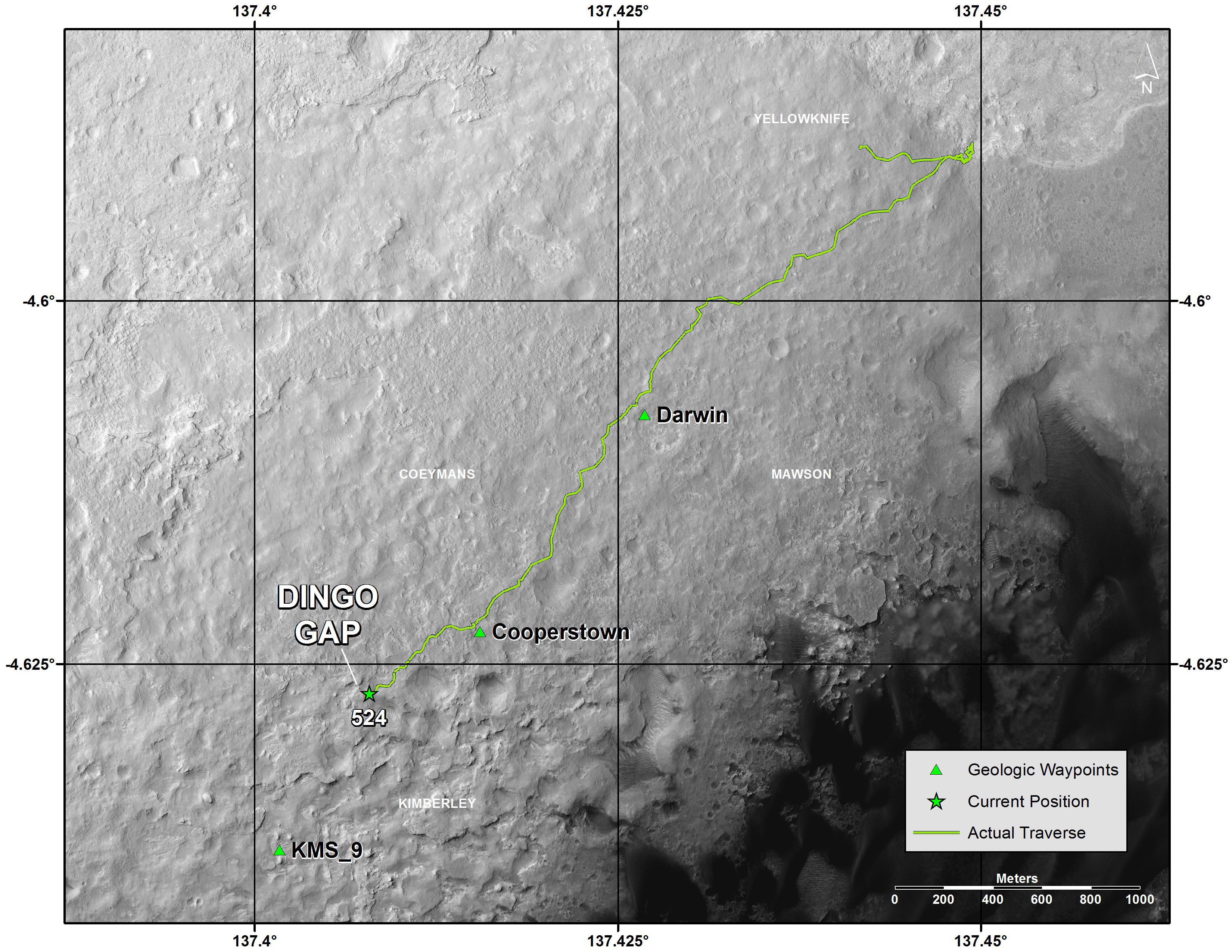
2014-04-16 |
Mars
|
Mars Reconnaissance Orbiter (MRO)
Mars Science Laboratory (MSL)
|
HiRISE
|
1322x1482x3 |
|
-
PIA18081:
-
Curiosity and Rover Tracks at 'the Kimberley,' April 2014
Full Resolution:
TIFF
(5.88 MB)
JPEG
(347.6 kB)
|
|
|
2014-04-16 |
Mars
|
Mars Reconnaissance Orbiter (MRO)
Mars Science Laboratory (MSL)
|
HiRISE
|
3287x3497x3 |
|
-
PIA18082:
-
Stereo View of Curiosity and Rover Tracks at 'the Kimberley,' April 2014
Full Resolution:
TIFF
(34.5 MB)
JPEG
(791.9 kB)
|
|
|
2014-08-01 |
Mars
|
Mars Reconnaissance Orbiter (MRO)
Mars Science Laboratory (MSL)
|
HiRISE
|
3300x2550x3 |
|
-
PIA18408:
-
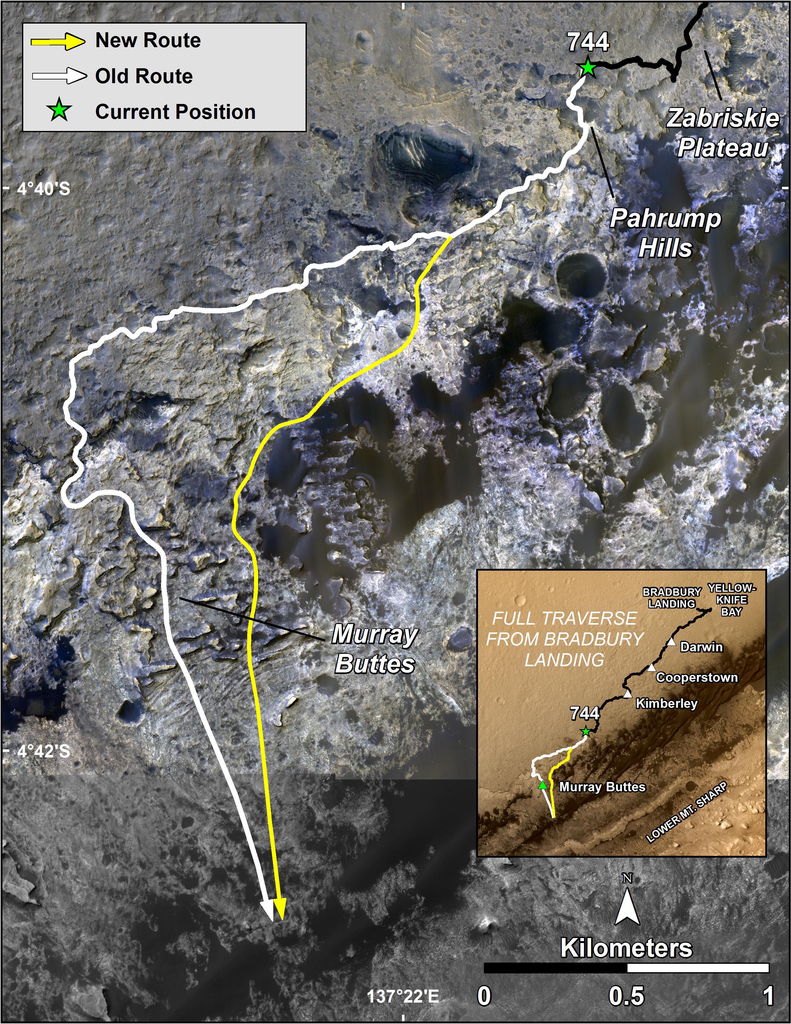
Sandy Martian Valleys in Curiosity's Near Future
Full Resolution:
TIFF
(25.26 MB)
JPEG
(1.213 MB)
|
|
|
2014-09-11 |
Mars
|
Mars Reconnaissance Orbiter (MRO)
Mars Science Laboratory (MSL)
|
HiRISE
|
2550x3300x3 |
|
-
PIA18475:
-
Curiosity's Next Steps
Full Resolution:
TIFF
(25.25 MB)
JPEG
(1.735 MB)
|
|
|
2014-09-11 |
Mars
|
Mars Reconnaissance Orbiter (MRO)
Mars Science Laboratory (MSL)
|
HiRISE
|
3300x2550x3 |

|
-
PIA18474:
-
Slopes of Mount Sharp
Full Resolution:
TIFF
(25.26 MB)
JPEG
(1.023 MB)
|


