PDS logoPlanetary Data System
PDS Information
Find a Node - Use these links to navigate to any of the 8 publicly accessible PDS Nodes.

This bar indicates that you are within the PDS enterprise which includes 6 science discipline nodes and 2 support nodes which are overseen by the Project Management Office at NASA's Goddard Space Flight Center (GSFC). Each node is led by an expert in the subject discipline, supported by an advisory group of other practitioners of that discipline, and subject to selection and approval under a regular NASA Research Announcement.
Click here to return to the Photojournal Home Page Click here to view a list of Photojournal Image Galleries Photojournal_inner_header
Latest Images  |  Spacecraft & Technology  |  Animations  |  Space Images App  |  Feedback  |  Photojournal Search  

PIA26018: Curiosity Looks Over the Hill
 Target Name:  Mars
 Is a satellite of:  Sol (our sun)
 Mission:  Mars Science Laboratory (MSL)
 Spacecraft:  Curiosity
 Instrument:  Navcam (MSL)
 Product Size:  7696 x 1503 pixels (w x h)
 Produced By:  University of Arizona
 Full-Res TIFF:  PIA26018.tif (8.746 MB)
 Full-Res JPEG:  PIA26018.jpg (1.204 MB)

Click on the image above to download a moderately sized image in JPEG format (possibly reduced in size from original)

Original Caption Released with Image:

click here for Figure A for PIA26018
Figure A

NASA's Curiosity Mars rover used its navigation cameras to capture this scene after making a detour around the toughest climb it has ever faced. After the rover struggled to crest a 23-degree slope covered with slippery sand and wheel-sized rocks, the mission decided to drive about 492 feet (150 meters) to a location where the slope was below 15 degrees, and there were fewer rocks and less sand.

This mosaic shows the view ahead as the rover began to ascend the area that was less challenging.

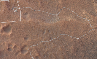
Figure A shows a map with Curiosity's route; the red dot is where the rover was positioned when it captured this panorama.

The map imagery was provided by the High Resolution Imaging Science Experiment (HiRISE) camera aboard NASA's Mars Reconnaissance Orbiter (MRO). Each black dot represents one of the rover's stops after a drive; in the upper left corner is a cluster of dots where the rover struggled to crest the steep slope. After the detour (the right side of the map), Curiosity visited a cluster of impact craters (the pockmarked terrain at the bottom of the map).

Curiosity was built by NASA's Jet Propulsion Laboratory, which is managed by Caltech in Pasadena, California. JPL leads the mission, along with MRO, on behalf of NASA's Science Mission Directorate in Washington.

The University of Arizona, in Tucson, operates HiRISE, which was built by Ball Aerospace & Technologies Corp., in Boulder, Colorado. MRO was built by Lockheed Martin Space. JPL manages the Mars Reconnaissance Orbiter Project for NASA's Science Mission Directorate.

For more about Curiosity, visit: http://mars.nasa.gov/msl.

For more about MRO, visit: http://mars.nasa.gov/mro.

Image Credit:
NASA/JPL-Caltech/USGS-Flagstaff/University of Arizona

Image Addition Date:
2023-08-03