The answers to this quiz appear in blue below each question.
1. The island is part of a volcanic arc system situated near a tectonic
plate boundary.
Answer: TRUE
Anatahan Island is one of the Northern Mariana Islands in the western
tropical Pacific. These islands are situated along the Izu-Mariana margin
where subduction of the Pacific plate beneath the Philippine Sea plate
creates a series of island arc volcanoes and the Earth's deepest ocean
trench.
2. The last major volcanic eruption on this island occurred in 1981.
Answer: FALSE
Anatahan had no known historical eruptions until May 2003.
3. The island contains mixed broadleaf forests, weathered clay soils,
and a lake infused by volcanic gases which raise the water's pH to
about 10.
Answer: FALSE
The infusion of volcanic gases lowers the pH of a water body. Volcanic
gases such as CO2 and SO2 react with water to form carbonic and
sulfuric acids, respectively.
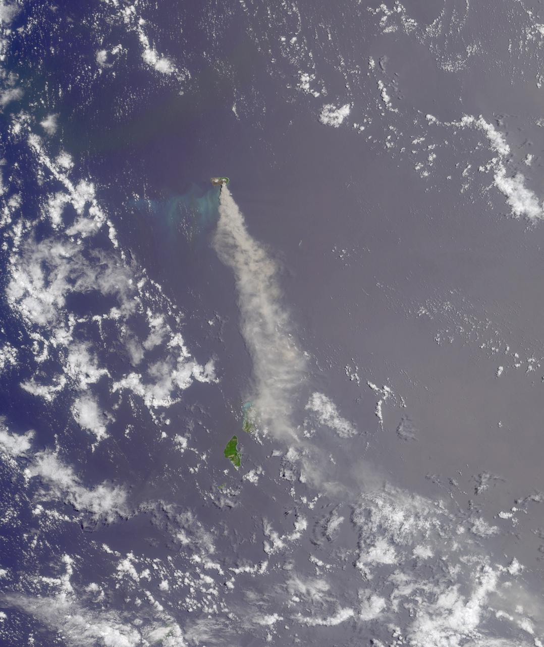
4. The type of clouds pictured here are often associated with lightning
and sustained rainstorms lasting several hours or more.
Answer: FALSE
The small cumulus clouds pictured here are not deep enough to produce
more than the occasional shower.
5. The island is inhabited by an endangered species of bird whose
newly-hatched young are feathered, able to walk, and able regulate
their body temperature.
Answer: TRUE
The Micronesian Megapode is an endangered species of bird that
inhabits the island. Megapode chicks are precocial at hatching and
the adults do not need to care for the young.
6. Snorkelers around this island are likely to encounter Acanthurus achilles
and Zanclus cornutus.
Answer: TRUE
Both fish, the Achilles Tang and the Moorish Idol, are found in the subtropical
waters of the Mariana Islands.
7. The archipelago to which the island belongs
was spotted in 1521 by a Portuguese explorer who named the islands after
the wife of a Spanish king.
Answer: FALSE
Although Portuguese explorer Ferdinand Magellan spotted the islands in 1521,
he named them "Las Isles de las Velas Latinas" (The Islands of the Latine Sails).
He later changed the name to "Las Islas de Los Ladrones" (The Islands of
Thieves). Eventually (in 1668), the Spanish renamed them "Las Marianas" in
honor of Mariana of Austria, the widow of Spanish King Philip IV.
8. The island is part of an archipelago that was claimed as a territory of one
nation in 1920 and of another nation in 1944.
Answer: Both TRUE and FALSE answers accepted
Japan took control of the Mariana Islands in 1914 (the first year of World War l)
and Germany released the islands to Japan in 1919. Japan received a mandate
over the islands in 1920 (after the ratification of the League of Nations). American
forces gained control of the islands in 1944, but it was not until 1947 that the area
was recognized as a Trust Territory of the United States by the United Nations.
9. The wreckage of a two-engine propeller-driven bomber is located on
the island.
Answer: FALSE
The wreckage of a World War II B-29 Superfortress lies on the north side edge
of the craters flat lands. However, the B-29 is a four-engine propeller-driven
bomber.
10. A director who made several films starring Marlene Dietrich also directed
her in a movie whose title contains this island's name.
Answer: FALSE
Fievre sur Anatahan (The Saga of Anatahan) (1953), is a film directed by Josef
von Sternberg, who made many films starring Marlene Dietrich. However, she
is not in this film.
11. In spring of 1990 the island's residents were evacuated because of the
impending landfall of a devastating typhoon.
Answer: FALSE
The evacuation of the island's residents in 1990 was prompted by a shallow
earthquake swarm that suggested the possibility of impending volcanic activity.
12. Bonus question: MISR captured this image of the island and its
surroundings on either January 6, March 11, or May 14. True or false?
Answer: FALSE
The eruption of Anatahan began on May 10th, but the Terra satellite did not
pass over this area on May 14th. One way to verify that the image was not
acquired on May 14th is to find another satellite image of Anatahan on May
14th. For example, this view of Anatahan from the Aquasatellite shows that
on May 14th the plume was blown toward the west, but the plume points
toward the south in the MISR image. You can determine exactly when MISR
captured this image by using the geographic coordinates of the islands, a
map of World Reference System-2 descending orbits (remember, Terra circles the Earth in the
same orbit as Landsat 7!) and visiting the MISR section at the
NASA-Langley Atmospheric Sciences Data Center. This image of the
Anatahan eruption was acquired on May 24, 2003 (during Terra orbit 18242).
MISR was built and is managed by NASA's Jet Propulsion Laboratory,
Pasadena, CA, for NASA's Office of Earth Science, Washington, DC. The
Terra satellite is managed by NASA's Goddard Space Flight Center,
Greenbelt, MD. JPL is a division of the California Institute of
Technology.
 Planetary Data System


