- Original Caption Released with Image:
-
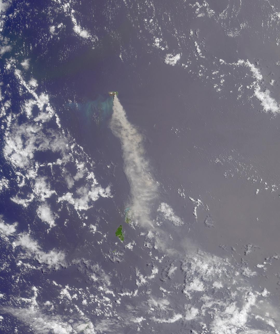
Here's another chance to play geographical detective! This natural-color image from the Multi-angle Imaging SpectroRadiometer (MISR) instrument on the Terra satellite represents an area of about 296 kilometers x 353 kilometers, and was acquired by MISR's nadir (vertical-viewing) camera sometime in 2003. These data were processed at the NASA Langley Atmospheric Sciences Data Center. Terra circles the Earth in the same orbit as Landsat 7, flying at an altitude of about 700 kilometers above the Earth's surface. Below are 12 statements about the island from which the large volcanic eruption plume is emanating. Use any reference materials you like and mark each statement true or false:1. The island is part of a volcanic arc system situated near a tectonic plate boundary.2. The last major volcanic eruption on this island occurred in 1981.3. The island contains mixed broadleaf forests, weathered clay soils, and a lake infused by volcanic gases which raise the water's pH to about 10.4. The type of clouds pictured here are often associated with lightning and sustained rainstorms lasting several hours or more.5. The island is inhabited by an endangered species of bird whose newly-hatched young are feathered, able to walk, and able regulate their body temperature.6. Snorkelers around this island are likely to encounter Acanthurus achilles and Zanclus cornutus.7. The archipelago to which the island belongs was spotted in 1521 by a Portuguese explorer who named the islands after the wife of a Spanish king.8. The island is part of an archipelago that was claimed as a territory of one nation in 1920 and of another nation in 1944.9. The wreckage of a two-engine propeller-driven bomber is located on the island.10. A director who made several films starring Marlene Dietrich also directed her in a movie whose title contains this island's name.11. In spring of 1990 the island's residents were evacuated because of the impending landfall of a devastating typhoon.12. Bonus question: MISR captured this image of the island and its surroundings on either January 6, March 11, or May 14. True or false?E-mail your answers, name (initials are acceptable if you prefer), and your hometown by Tuesday, June 3, 2003 to suggestions@mail-misr.jpl.nasa.gov.Answers will be published on the MISR Quiz page in conjunction with the next weekly image release. The names and home towns of respondents who answer all questions correctly by the deadline will also be published in the order responses were received. The first 3 people on this list who are not affiliated with NASA, JPL, or MISR and who have not previously won a prize will be sent a print of the image.A new "Where on Earth...?" mystery appears as the MISR "image of the week" approximately once every two months. A new image of the week is released every Wednesday at noon Pacific time on the MISR home page, http://www-misr.jpl.nasa.gov. The image also appears on the Earth Observatory, http://earthobservatory.nasa.gov/, and on the Atmospheric Sciences Data Center home page, http://eosweb.larc.nasa.gov/, though usually with a several-hour delay.MISR was built and is managed by NASA's Jet Propulsion Laboratory, Pasadena, CA, for NASA's Office of Earth Science, Washington, DC. The Terra satellite is managed by NASA's Goddard Space Flight Center, Greenbelt, MD. JPL is a division of the California Institute of Technology.
- Image Credit:
-
NASA/GSFC/LaRC/JPL, MISR Team.
Image Addition Date: -
2003-05-28
|
