- Original Caption Released with Image:
-
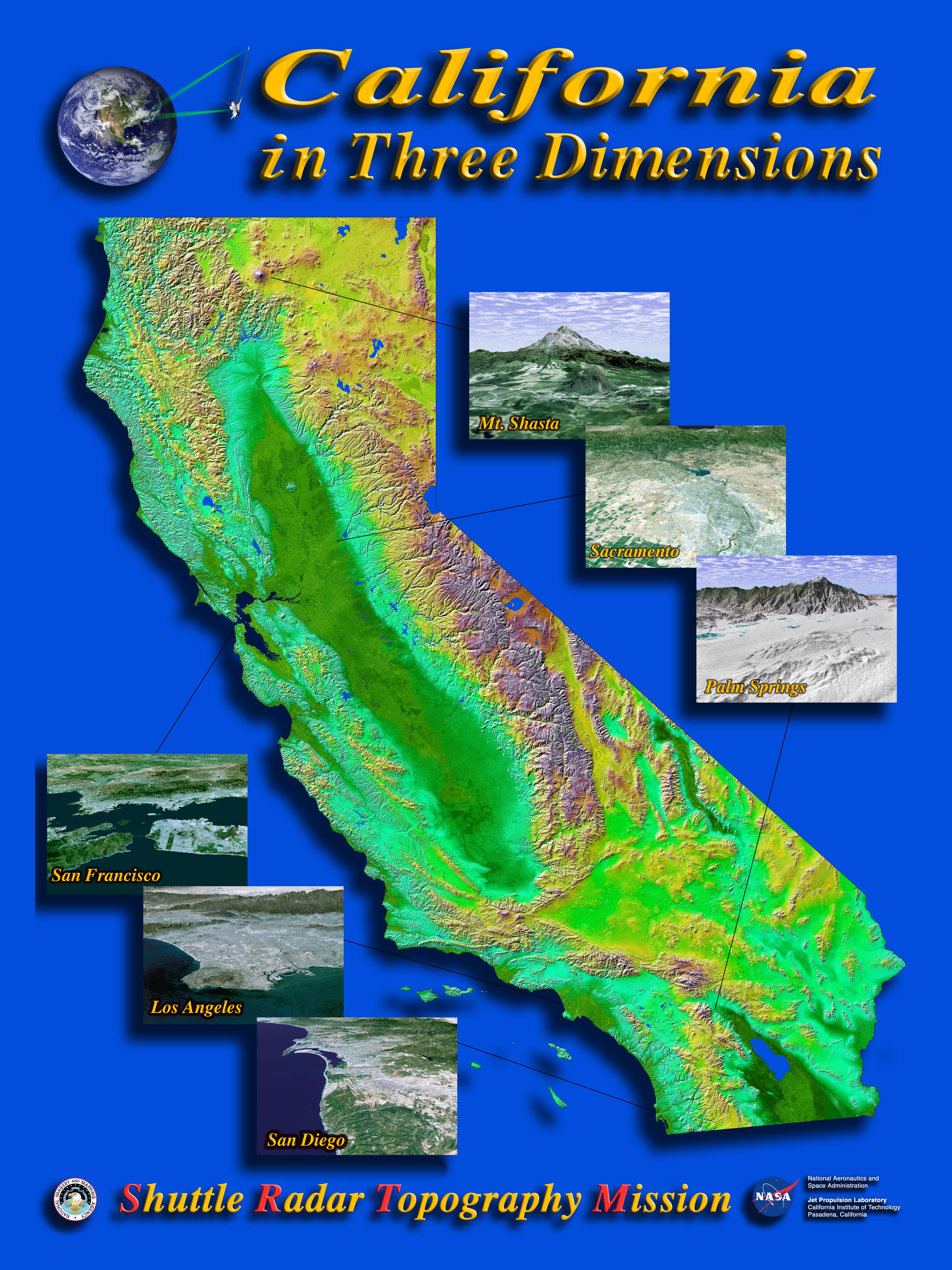
The diversity of landforms that make up the state of California is evident in this new [sic] rendition of the 3-D topography of the state. The Central Valley, flanked on the east by the Sierra Nevada, dominates the scene with San Francisco and Monterey Bays clearly visible at left center. Other features of interest include Lake Tahoe at the edge to the right of San Francisco, Mono Lake below Lake Tahoe, and the Salton Sea at the lower right. The prominent sideways "V" in the southern part of the state is the intersection of the Garlock and San Andreas Faults - to the east is the Mojave Desert. Offshore are the Channel Islands and to the right of them lies the city of Los Angeles.(see: PIA03333) Two visualization methods were combined to produce this image: shading and color coding of topographic height. The shade image was derived by computing topographic slope in the northwest-southeast direction. North-facing slopes appear bright and south-facing slopes appear dark. Color coding is directly related to topographic height, with blue and green at the lower elevations, rising through yellow and brown to white at the highest elevations. Insets: - PIA03328 Mount Shasta
- At more than 4,300 meters (14,000 feet), Mount Shasta is California's tallest volcano and part of the Cascade chain of volcanoes extending south from Washington. This computer-generated perspective viewed from the west also includes Shastina, a slightly smaller volcanic cone left of Shasta's summit; and Black Butte, another volcano in the right foreground.
- PIA03329 San Francisco Bay
- The defining landmarks of San Francisco, its bay and the San Andreas Fault are clearly seen in this computer-generated perspective viewed from the south. Running from the bottom of the scene diagonally up to the left, the trough of the San Andreas Fault is occupied by Crystal Springs Reservoir and San Andreas Lake. Interstate 280 winds along the side of the fault. San Francisco International Airport is the angular feature projecting into the bay just below San Bruno Mountain, the elongated ridge cutting across the peninsula. The hills of San Francisco can be seen beyond San Bruno Mountain and beyond the city, the Golden Gate.
- PIA03330 San Diego
- The influence of topography on the growth of the city of San Diego is seen clearly in this computer-generated perspective viewed from the south. The Peninsular Ranges to the east of the city have channeled development of the cities of La Mesa and El Cajon, above the center. San Diego itself clusters around the bay enclosed by Point Loma and Coronado Island. In the mountains to the right, Lower Otay Lake and Sweetwater Reservoir are the dark patches.
- PIA03331 Sacramento
- California's state capitol, Sacramento, can be seen clustered along the American and Sacramento Rivers in this computer-generated perspective viewed from the west. Folsom Lake is in the center and the Sierra Nevadan is above, with the edge of Lake Tahoe just visible at top center.
- PIA03348 Los Angeles
- Most of Los Angeles is visible in this computer-generated north-northeast perspective viewed from above the Pacific Ocean. In the foreground the hilly Palos Verdes peninsula lies to the left of the harbor at Long Beach, and in the middle distance the various communities that comprise the greater Los Angeles area appear as shades of grey and white. In the distance the San Gabriel Mountains rise up to separate the basin from the Mojave Desert, which can be seen near the top of the image.
- PIA03334 Palm Springs
- The city of Palm Springs nestles at the base of Mount San Jacinto in this computer-generated perspective viewed from the east. The many golf courses in the area show up as irregular green areas while the two prominent lines passing through the middle of the image are Interstate 10 and the adjacent railroad tracks. The San Andreas Fault passes through the middle of the sandy Indio Hills in the foreground.
Elevation data used in this image was acquired by the Shuttle Radar Topography Mission (SRTM) aboard the Space Shuttle Endeavour, launched on February 11, 2000. SRTM used the same radar instrument that comprised the Spaceborne Imaging Radar-C/X-Band Synthetic Aperture Radar (SIR-C/X-SAR) that flew twice on the Space Shuttle Endeavour in 1994. SRTM was designed to collect 3-D measurements of the Earth's surface. To collect the 3-D data, engineers added a 60-meter (approximately 200-foot) mast, installed additional C-band and X-band antennas, and improved tracking and navigation devices. The mission is a cooperative project between NASA, the National Imagery and Mapping Agency (NIMA) of the U.S. Department of Defense, and the German and Italian space agencies. It is managed by NASA's Jet Propulsion Laboratory, Pasadena, Calif., for NASA's Earth Science Enterprise, Washington, D.C.California Mosaic: Size: 950 by 1100 kilometers ( 590 by 680 miles)
Location: 32.5-42 degrees North latitude, 114-125 degrees West longitude
Orientation: North toward the top
Image Data: Shaded and colored SRTM elevation model
Original Data Resolution: SRTM 1 arcsecond (30 meters or 98 feet)
Date Acquired: February 2000
- Image Credit:
-
NASA/JPL/NIMA
Image Addition Date: -
2002-04-04
|
 Planetary Data System


